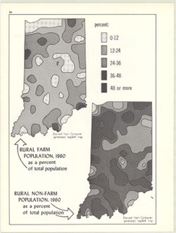
2 maps on 1 sheet, Rural farm population, 1960, as a percent of total population and Rural non-farm population, 1960, as a percent of total population. Compu...
Call Number:
G4091.E2 1960 .K59
Caption:
Imprint: Bloomington, Indiana : Department of Geography, Indiana University, [1970]
Physical Description:
Dimensions: on sheet 28 x 21 cm and Scale: Approximately 1:3,000,000
Alternate Identifier:
Title Control Number: a15948031 and Alternate ID: 317383IP
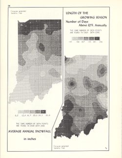
2 maps on 1 sheet, Average annual snowfall in inches and Length of the growing season: number of days above 32°F. annually. Computer generated isometric ...
Call Number:
G4091.C884 1970 .K56
Caption:
Imprint: Bloomington, Indiana : Department of Geography, Indiana University, [1970]
Physical Description:
Scale: Approximately 1:3,000,000 and Dimensions: each 26 x 10 cm, on sheet 28 x 21 cm
Alternate Identifier:
Alternate ID: 317383IP and Title Control Number: a15998435
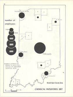
Graduated symbol map. Detached from: An atlas of Indiana / by Robert C. Kingsbury , with contributions from John M. Hollingsworth and others. Bloomington,...
Call Number:
G4091.G8 1967 .K61
Caption:
Imprint: Bloomington, Indiana : Department of Geography, Indiana University, [1970]
Physical Description:
Dimensions: 26 x 18 cm, on sheet 28 x 21 cm and Scale: Approximately 1:1,950,000
Alternate Identifier:
Alternate ID: 317383IP and Title Control Number: a15951282
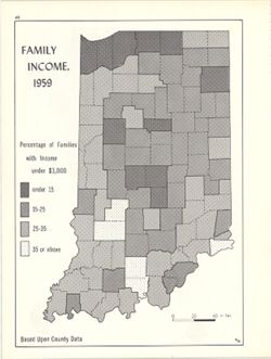
Choropleth map showing percentage of families with income less than $3,000 by county. Detached from: An atlas of Indiana / by Robert C. Kingsbury , with c...
Call Number:
G4091.E74 1959 .K55
Caption:
Imprint: Bloomington, Indiana : Department of Geography, Indiana University, [1970]
Physical Description:
Dimensions: 26 x 18 cm and Scale: Approximately 1:2,000,000
Alternate Identifier:
Alternate ID: 317383IP and Title Control Number: a15947824
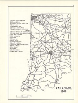
Includes index. Detached from: An atlas of Indiana / by Robert C. Kingsbury , with contributions from John M. Hollingsworth and others. Bloomington, India...
Call Number:
G4091.P3 1969 .K56
Caption:
Imprint: Bloomington, Indiana : Department of Geography, Indiana University, [1970]
Physical Description:
Scale: Approximately 1:2,300,000 and Dimensions: 26 x 18 cm, on sheet 28 x 21 cm
Alternate Identifier:
Alternate ID: 317383IP and Title Control Number: a15934461