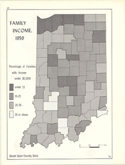
Choropleth map showing percentage of families with income less than $3,000 by county. Detached from: An atlas of Indiana / by Robert C. Kingsbury , with c...
Call Number:
G4091.E74 1959 .K55
Caption:
Imprint: Bloomington, Indiana : Department of Geography, Indiana University, [1970]
Physical Description:
Dimensions: 26 x 18 cm and Scale: Approximately 1:2,000,000
Alternate Identifier:
Alternate ID: 317383IP and Title Control Number: a15947824
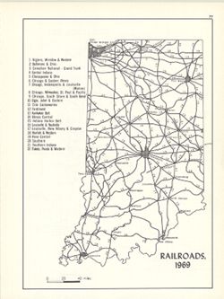
Includes index. Detached from: An atlas of Indiana / by Robert C. Kingsbury , with contributions from John M. Hollingsworth and others. Bloomington, India...
Call Number:
G4091.P3 1969 .K56
Caption:
Imprint: Bloomington, Indiana : Department of Geography, Indiana University, [1970]
Physical Description:
Scale: Approximately 1:2,300,000 and Dimensions: 26 x 18 cm, on sheet 28 x 21 cm
Alternate Identifier:
Alternate ID: 317383IP and Title Control Number: a15934461
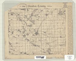
Geographic Subject: Indiana, Topical Subject: Roads, and Topical Subject: Administrative and political divisions
Creator:
National Map Company
Publisher:
National Map Company
Date Created:
1931
Identifier:
VAC3073-M-00016
Genre:
Road maps and Thematic maps
Geographic Location:
Coordinates: W0880700 W0844500 N0414500 N0375200
Related URL:
Catalog URL: https://iucat.iu.edu/catalog/6087917
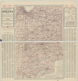
Abstract:
Full color maps of Indiana on both sides in two sheets. Shows villages, post offices, steam and electric railways with stations and distances between station...
Call Number:
G4090 1931 .N38
Caption:
Imprint: [Indianapolis, In] : National Map Company, 1931.
Physical Description:
Dimensions: 113 x 75 cm, on sheet 128 x 122 cm and Scale: Approximately 1:433,520. 7 miles to one inch.
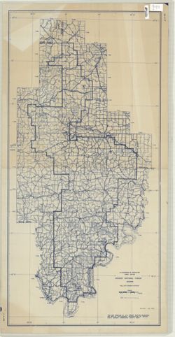
Geographic Subject: Hoosier National Forest (Ind.)
Creator:
United States. Forest Service
Publisher:
United States. Forest Service
Date Created:
1958
Identifier:
VAC3073-M-00015
Genre:
Maps
Geographic Location:
Coordinates: W0865200 W0861700 N0390000 N0374900
Related URL:
Catalog URL: https://iucat.iu.edu/catalog/4937903
Abstract:
Blue line print. "This map was compiled by the U.S. Forest Service, Milwaukee, Wis. 1956 by photographic reproduction of Indiana State Highway Commissio...
Relief shown by contours and spot heights. Depths by contours and soundings. "Contour interval 5 and 10 feet." Red tint indicates areas in which on...