Geographic Subject: Indiana, Topical Subject: Coal mines and mining, and Topical Subject: Coal
Creator:
Coal Trade Association of Indiana
Publisher:
Coal Trade Association of Indiana
Date Created:
1947
Identifier:
VAC3073-M-00116
Genre:
Thematic maps and Mine maps
Geographic Location:
Coordinates: W0880500 W0844700 N0414500 N0374600
Related URL:
Catalog URL: https://iucat.iu.edu/catalog/5277927
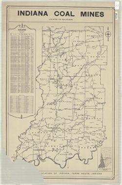
Abstract:
Shows southwestern Indiana from Newport in the north to the Ohio River on the south and from the Wabash River on the west to Morgantown on the east. Includes...
Call Number:
G4091.H9 1947 .C63
Caption:
Imprint: Terre Haute, Ind. : The Association, [1947?]
Physical Description:
Dimensions: 84 x 59 cm and Scale: Scale not given.
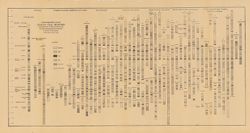
Includes approximately 100 stratigraphic columns and correlation lines. Detached from: The coal deposits of Indiana : a supplemental report to the one iss...
Call Number:
G4091.H9 1908 .S77
Caption:
Imprint: [Indianapolis] : [Indiana Department of Geology and Natural Resources], [1909]
Physical Description:
Scale: Horizontal scale not given. Vertical scale approximately 1:960. 1 inch = 80 feet and Dimensions: 40 x 75 cm
Alternate Identifier:
Title Control Number: a18307694 and Alternate ID: 390726IP
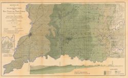
Geographic Subject: Knox County (Ind.), Geographic Subject: Martin County (Ind.), Topical Subject: Geology, Geographic Subject: Daviess County (Ind.), Geogra...
Creator:
Ashley, Geo. H. (George Hall), 1866-1951
Publisher:
Indiana. Department of Geology and Natural Resources
Relief shown by spot heights. Includes map showing coal locations and features, railroads, and quarries as well as a vertical cross section along the B. &...
Call Number:
G4093.K5H9 1898 .A84
Caption:
Imprint: Indianapolis : Wm. B. Burford, [1899]
Physical Description:
Dimensions: 48 x 78 cm and Scale: Approximately 1:126,720. 2 miles = 1 inch
Alternate Identifier:
Alternate ID: 390726IP and Title Control Number: a18272877