
Search Constraints
You searched for:
Subject
Topical Subject: Maps
Remove constraint Subject: Topical Subject: Maps
Search Results
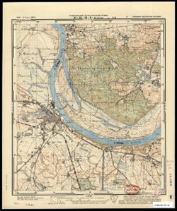
-
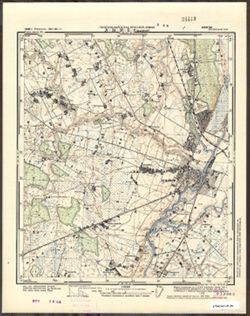
- Subject:
- Geographic Subject: Kėdainiai, Topical Subject: Soviet Union, and Topical Subject: Maps
- Publisher:
- Генеральный штаб Красной Армии
- Language:
- Russian
- Date Created:
- 1941
- Identifier:
- VAC9619-003628
- Genre:
- Military Maps and Topographic Maps
- Geographic Location:
- Coordinates: 55.25, 23.875, 55.333, 24
- Related URL:
- Download GeoTIFF: https://drive.google.com/file/d/1y_l1KE4DpoOq397m9qkZufHFP5Z8L6wR/view?usp=sharing and Catalog URL: https://iucat.iu.edu/catalog/14701157
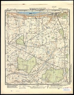
- Abstract:
- Modern area represented: Kėdainiai, Lithuania
- Call Number:
- G7063.K2 s25 .S6 sheet N-34-36-B-b
- Caption:
- Секретно
- City:
- Кедайняй (Kėdainiai)
- Copyright Holder:
- No Copyright - United States
- Country:
- СССР (USSR)
- State/Province:
- Литовская ССР (Lithuanian Soviet Socialist Republic)
- Physical Description:
- Scale: 1:25,000
- Persistent URL:
- http://purl.dlib.indiana.edu/iudl/images/VAC9619/VAC9619-003628
- Provenance:
- CIA Map Branch -- Received
-
- Subject:
- Topical Subject: Soviet Union, Topical Subject: Maps, and Geographic Subject: Rugėnai
- Publisher:
- Генеральный штаб Красной Армии
- Language:
- Russian
- Date Created:
- 1940
- Identifier:
- VAC9619-003626
- Genre:
- Topographic Maps and Military Maps
- Geographic Location:
- Coordinates: 55.1667, 23.625, 55.25, 23.75
- Related URL:
- Catalog URL: https://iucat.iu.edu/catalog/14701157 and Download GeoTIFF: https://drive.google.com/file/d/17B7GRYPqAsYzQVoyLT1DzMceCqi0OZtz/view?usp=sharing
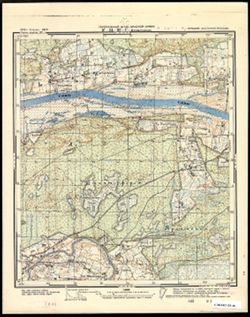
- Abstract:
- Modern area represented: Rugėnai, Lithuania
- Call Number:
- G7063.K2 s25 .S6 sheet N-34-36-A-d
- Caption:
- Секретно
- City:
- Ругяны (Rugyany)
- Copyright Holder:
- No Copyright - United States
- Country:
- СССР (USSR)
- State/Province:
- Литовская ССР (Lithuanian Soviet Socialist Republic)
- Physical Description:
- Scale: 1:25,000
- Persistent URL:
- http://purl.dlib.indiana.edu/iudl/images/VAC9619/VAC9619-003626
- Provenance:
- Army Map Service Library, OMAHA, Library of Congress Geography & Map Division
-
- Subject:
- Topical Subject: Soviet Union, Geographic Subject: Lipliūnai, and Topical Subject: Maps
- Publisher:
- Генеральный штаб Красной Армии
- Language:
- Russian
- Date Created:
- 1941
- Identifier:
- VAC9619-003627
- Genre:
- Military Maps and Topographic Maps
- Geographic Location:
- Coordinates: 55.25, 23.75, 55.333, 23.875
- Related URL:
- Download GeoTIFF: https://drive.google.com/file/d/1BZPo9BwKtJMeOdSG5Ejl5_llnhkhws6R/view?usp=sharing and Catalog URL: https://iucat.iu.edu/catalog/14701157
- Abstract:
- Modern area represented: Lipliūnai, Lithuania
- Call Number:
- G7063.K2 s25 .S6 sheet N-34-36-B-a
- Caption:
- Секретно
- City:
- Липлюны (Liplyuny)
- Copyright Holder:
- No Copyright - United States
- Country:
- СССР (USSR)
- State/Province:
- Литовская ССР (Lithuanian Soviet Socialist Republic)
- Physical Description:
- Scale: 1:25,000
- Persistent URL:
- http://purl.dlib.indiana.edu/iudl/images/VAC9619/VAC9619-003627
- Provenance:
- Army Map Service Library, OMAHA, Library of Congress Geography & Map Division
-
- Subject:
- Geographic Subject: Pelutava, Topical Subject: Maps, and Topical Subject: Soviet Union
- Publisher:
- Генеральный штаб Красной Армии
- Language:
- Russian
- Date Created:
- 1941
- Identifier:
- VAC9619-003625
- Genre:
- Military Maps and Topographic Maps
- Geographic Location:
- Coordinates: 55.25, 23.625, 55.333, 23.75
- Related URL:
- Catalog URL: https://iucat.iu.edu/catalog/14701157 and Download GeoTIFF: https://drive.google.com/file/d/1DMT_ZPZTJ973RotaZTW0Kg8NpHoTRTsK/view?usp=sharing
- Abstract:
- Modern area represented: Pelutava, Lithuania
- Call Number:
- G7063.K2 s25 .S6 sheet N-34-36-A-b
- Caption:
- Секретно
- City:
- Пелутово (Pelutovo)
- Copyright Holder:
- No Copyright - United States
- Country:
- СССР (USSR)
- State/Province:
- Литовская ССР (Lithuanian Soviet Socialist Republic)
- Physical Description:
- Scale: 1:25,000
- Persistent URL:
- http://purl.dlib.indiana.edu/iudl/images/VAC9619/VAC9619-003625
- Provenance:
- Army Map Service Library, OMAHA, Library of Congress Geography & Map Division
-
- Subject:
- Topical Subject: Maps, Geographic Subject: Gelgaudiškis, and Topical Subject: Soviet Union
- Publisher:
- Генеральный штаб Красной Армии
- Language:
- Russian
- Date Created:
- 1941
- Identifier:
- VAC9619-003624
- Genre:
- Topographic Maps and Military Maps
- Geographic Location:
- Coordinates: 55, 22.875, 55.083, 23
- Related URL:
- Download GeoTIFF: https://drive.google.com/file/d/1LkdEq-r2hwsukUlB50oqATuPo1KhJSrX/view?usp=sharing and Catalog URL: https://iucat.iu.edu/catalog/14701157
- Abstract:
- Modern area represented: Gelgaudiškis, Lithuania
- Call Number:
- G7063.K2 s25 .S6 sheet N-34-34-D-d
- Caption:
- Секретно
- City:
- Гелгудышки (Gelgudyshki)
- Copyright Holder:
- No Copyright - United States
- Country:
- СССР (USSR)
- State/Province:
- Литовская ССР (Lithuanian Soviet Socialist Republic)
- Physical Description:
- Scale: 1:25,000
- Persistent URL:
- http://purl.dlib.indiana.edu/iudl/images/VAC9619/VAC9619-003624
- Provenance:
- CIA Map Branch -- Received
-
- Subject:
- Topical Subject: Soviet Union, Geographic Subject: Jurbarkas, and Topical Subject: Maps
- Publisher:
- Генеральный штаб Красной Армии
- Language:
- Russian
- Date Created:
- 1941
- Identifier:
- VAC9619-003623
- Genre:
- Topographic Maps and Military Maps
- Geographic Location:
- Coordinates: 55, 22.75, 55.083, 22.875
- Related URL:
- Download GeoTIFF: https://drive.google.com/file/d/1pY3PzwuuZayzrphKVkKyWFuSZcaz01Xj/view?usp=sharing and Catalog URL: https://iucat.iu.edu/catalog/14701157
- Abstract:
- Modern area represented: Jurbarkas, Lithuania
- Call Number:
- G7063.K2 s25 .S6 sheet N-34-34-D-c
- Caption:
- Секретно
- City:
- Юрбург (Yurburg)
- Copyright Holder:
- No Copyright - United States
- Country:
- СССР (USSR)
- State/Province:
- Литовская ССР (Lithuanian Soviet Socialist Republic)
- Physical Description:
- Scale: 1:25,000
- Persistent URL:
- http://purl.dlib.indiana.edu/iudl/images/VAC9619/VAC9619-003623
- Provenance:
- DMA Topographic Center, Army Map Service Library, Library of Congress Geography & Map Division
-
- Subject:
- Topical Subject: Soviet Union, Topical Subject: Maps, and Geographic Subject: Viešvilė
- Publisher:
- Генеральный штаб Красной Армии
- Language:
- Russian
- Date Created:
- 1941
- Identifier:
- VAC9619-003621
- Genre:
- Military Maps and Topographic Maps
- Geographic Location:
- Coordinates: 55, 22.375, 55.083, 22.5
- Related URL:
- Catalog URL: https://iucat.iu.edu/catalog/14701157 and Download GeoTIFF: https://drive.google.com/file/d/1O1k_CVehwHDFdfHIlpINaO0hxDw_fwx3/view?usp=sharing
- Abstract:
- Modern area represented: Viešvilė, Lithuania
- Call Number:
- G7063.K2 s25 .S6 sheet N-34-33-D-d
- City:
- Вишвилл (Wischwill)
- Copyright Holder:
- No Copyright - United States
- Country:
- Германия (Восточная Пруссия) (Germany (East Prussia))
- Physical Description:
- Scale: 1:25,000
- Persistent URL:
- http://purl.dlib.indiana.edu/iudl/images/VAC9619/VAC9619-003621
- Provenance:
- Army Map Service Library, OMAHA, Library of Congress Geography & Map Division
-
- Subject:
- Geographic Subject: Nikol’skoye, Topical Subject: Maps, and Topical Subject: Soviet Union
- Publisher:
- Генеральный штаб Красной Армии
- Language:
- Russian
- Date Created:
- 1941
- Identifier:
- VAC9619-003620
- Genre:
- Topographic Maps and Military Maps
- Geographic Location:
- Coordinates: 55, 22.25, 55.085, 22.375
- Related URL:
- Download GeoTIFF: https://drive.google.com/file/d/1RCiWalJv_0lzFatAUvHYnfCBTUbYJRms/view?usp=sharing and Catalog URL: https://iucat.iu.edu/catalog/14701157
- Abstract:
- Modern area represented: Никольское (Nikol’skoye), Kaliningradskaya oblast, Russia
- Call Number:
- G7063.K2 s25 .S6 sheet N-34-33-D-c
- City:
- Гиверлаукен (Giewerlauken)
- Copyright Holder:
- No Copyright - United States
- Country:
- Германия (Восточная Пруссия) (Germany (East Prussia))
- Physical Description:
- Scale: 1:25,000
- Persistent URL:
- http://purl.dlib.indiana.edu/iudl/images/VAC9619/VAC9619-003620
- Provenance:
- CIA Map Branch -- Received
-
- Subject:
- Topical Subject: Maps, Topical Subject: Soviet Union, and Geographic Subject: Bol’shoye Selo
- Publisher:
- Генеральный штаб Красной Армии
- Language:
- Russian
- Date Created:
- 1941
- Identifier:
- VAC9619-003619
- Genre:
- Topographic Maps and Military Maps
- Geographic Location:
- Coordinates: 55, 22.125, 55.085, 22.25
- Related URL:
- Download GeoTIFF: https://drive.google.com/file/d/1G8e-s8D70JK64IS6uGWaOkSCJ_W2ACgw/view?usp=sharing and Catalog URL: https://iucat.iu.edu/catalog/14701157
- Abstract:
- Modern area represented: Большое Село (Bol’shoye Selo), Kaliningradskaya oblast, Russia
- Call Number:
- G7063.K2 s25 .S6 sheet N-34-33-C-d
- City:
- Гросс Ленкенингкен (Gross Lenkeningken)
- Copyright Holder:
- No Copyright - United States
- Country:
- Германия (Восточная Пруссия) (Germany (East Prussia))
- Physical Description:
- Scale: 1:25,000
- Persistent URL:
- http://purl.dlib.indiana.edu/iudl/images/VAC9619/VAC9619-003619
- Provenance:
- Army Map Service Library, OMAHA, Library of Congress Geography & Map Division
-
- Subject:
- Topical Subject: Soviet Union, Topical Subject: Maps, and Geographic Subject: Neman
- Publisher:
- Генеральный штаб Красной Армии
- Language:
- Russian
- Date Created:
- 1941
- Identifier:
- VAC9619-003618
- Genre:
- Military Maps and Topographic Maps
- Geographic Location:
- Coordinates: 55, 22, 55.083, 22.125
- Related URL:
- Download GeoTIFF: https://drive.google.com/file/d/1LUB10sofJFKrRQZwaCEdeNJ7Ed8-2JsY/view?usp=sharing and Catalog URL: https://iucat.iu.edu/catalog/14701157
- Abstract:
- Modern area represented: Neman, Lithuania
- Call Number:
- G7063.K2 s25 .S6 sheet N-34-33-C-c
- City:
- Рагнит (Ragnit)
- Copyright Holder:
- No Copyright - United States
- Country:
- Германия (Восточная Пруссия) (Germany (East Prussia))
- Physical Description:
- Scale: 1:25,000
- Persistent URL:
- http://purl.dlib.indiana.edu/iudl/images/VAC9619/VAC9619-003618
- Provenance:
- CIA Map Branch -- Received, Library of Congress Geography & Map Division
