
Search Constraints
You searched for:
Publisher
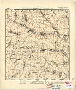
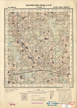
Главное Управление Геодезии и Картографии при СНК СССР
Remove constraint Publisher: Главное Управление Геодезии и Картографии при СНК СССР
« Previous |
1 - 50 of 127
|
Next »
Search Results
-
- Description:
- 1934
- Subject:
- Topical Subject: Maps, Geographic Subject: Okhrimivka, and Topical Subject: Soviet Union
- Publisher:
- Главное Управление Геодезии и Картографии при СНК СССР
- Language:
- Russian
- Date Created:
- 1941
- Identifier:
- VAC9619-001913
- Genre:
- Military Maps and Topographic Maps
- Geographic Location:
- Coordinates: 46.3333, 35, 46.6667, 35.5
- Related URL:
- Catalog URL: https://iucat.iu.edu/catalog/5020129 and Download GeoTIFF: https://drive.google.com/open?id=1eqKwauRt9y66nxYzOrAKEMy6XqSJedsf
- Abstract:
- Modern area represented: Okhrimivka, Zaporizhia oblast, Ukraine
- Call Number:
- G7000 s100 .S7 sheet L-36-59
- Caption:
- Для служебного пользования
- City:
- Ефремовка (Yefremovka)
- Copyright Holder:
- No Copyright - United States
- Country:
- СССР (USSR)
- State/Province:
- Запорожская область (Zaporizhia oblast), Украинская ССР (Ukrainian Soviet Socialist Republic), Приазовский район (Pryazovsky district), Генический район (Hen...
- Physical Description:
- Scale: 1:100,000
- Persistent URL:
- http://purl.dlib.indiana.edu/iudl/images/VAC9619/VAC9619-001913
- Provenance:
- DMA Topographic Center, Army Map Service Library, OMAHA
-
- Description:
- 1934
- Subject:
- Topical Subject: Soviet Union, Topical Subject: Maps, and Geographic Subject: Noviy Azov
- Publisher:
- Главное Управление Геодезии и Картографии при СНК СССР
- Language:
- Russian
- Date Created:
- 1936
- Identifier:
- VAC9619-001924
- Genre:
- Topographic Maps and Military Maps
- Geographic Location:
- Coordinates: 46, 35, 46.3333, 35.5
- Related URL:
- Download GeoTIFF: https://drive.google.com/open?id=1kXYrv1G8OZSvZdSM2SJdkDOcDlraF50I and Catalog URL: https://iucat.iu.edu/catalog/5020129
- Abstract:
- Modern area represented: Noviy Azov, Kherson oblast, Ukraine
- Call Number:
- G7000 s100 .S7 sheet L-36-71
- Caption:
- Для служебного пользования
- City:
- Нов. Азов (Noviy Azov)
- Copyright Holder:
- No Copyright - United States
- Country:
- СССР (USSR)
- State/Province:
- Запорожская область (Zaporizhia oblast) and Украинская ССР (Ukrainian Soviet Socialist Republic)
- Physical Description:
- Scale: 1:100,000
- Persistent URL:
- http://purl.dlib.indiana.edu/iudl/images/VAC9619/VAC9619-001924
- Provenance:
- CIA Map Library
-
- Description:
- 1940
- Subject:
- Geographic Subject: Uspenskoye, Topical Subject: Maps, and Topical Subject: Soviet Union
- Publisher:
- Главное Управление Геодезии и Картографии при СНК СССР
- Language:
- Russian
- Date Created:
- 1941
- Identifier:
- VAC9619-003269
- Genre:
- Military Maps and Topographic Maps
- Geographic Location:
- Coordinates: 51.333, 35.5, 51.667, 36
- Related URL:
- Catalog URL: https://iucat.iu.edu/catalog/5020129 and Download GeoTIFF: https://drive.google.com/file/d/13H2_z6iANzkTqQ8UbHlKPgALvELxyv5l/view?usp=sharing
- Abstract:
- Modern area represented: Uspenskoye, Kursk oblast, Russia
- Call Number:
- G7000 s100 .S7 sheet M-36-24
- Caption:
- Для служебного пользования
- City:
- Успенское (Uspenskoye)
- Copyright Holder:
- No Copyright - United States
- Country:
- СССР (USSR)
- State/Province:
- Курская область (Kursk oblast) and РСФСР (RSFSR)
- Physical Description:
- Scale: 1:100,000
- Persistent URL:
- http://purl.dlib.indiana.edu/iudl/images/VAC9619/VAC9619-003269
- Provenance:
- DMA Topographic Center, Army Map Service Library, OMAHA, Library of Congress Geography & Map Division
-
- Description:
- 1938
- Subject:
- Geographic Subject: Khotin, Topical Subject: Soviet Union, and Topical Subject: Maps
- Publisher:
- Главное Управление Геодезии и Картографии при СНК СССР
- Language:
- Russian
- Date Created:
- 1941
- Identifier:
- VAC9619-003277
- Genre:
- Military Maps and Topographic Maps
- Geographic Location:
- Coordinates: 51, 34.5, 51.333, 35
- Related URL:
- Download GeoTIFF: https://drive.google.com/file/d/13__g-nTLeVPp1DfWoC52MRNrfC4Ny2Q1/view?usp=sharing and Catalog URL: https://iucat.iu.edu/catalog/5020129
- Abstract:
- Modern area represented: Khotin, Sumy oblast, Ukraine
- Call Number:
- G7000 s100 .S7 sheet M-36-34
- City:
- Хотень (Khotin)
- Copyright Holder:
- No Copyright - United States
- Country:
- СССР (USSR)
- State/Province:
- Сумская область (Sumy oblast), Курская область (Kursk oblast), Украинская ССР (Ukrainian Soviet Socialist Republic), and РСФСР (RSFSR)
- Physical Description:
- Scale: 1:100,000
- Persistent URL:
- http://purl.dlib.indiana.edu/iudl/images/VAC9619/VAC9619-003277
- Provenance:
- DMA Topographic Center, Army Map Service Library
-
- Description:
- 1939
- Subject:
- Geographic Subject: Sudzha, Topical Subject: Maps, and Topical Subject: Soviet Union
- Publisher:
- Главное Управление Геодезии и Картографии при СНК СССР
- Language:
- Russian
- Date Created:
- 1941
- Identifier:
- VAC9619-003278
- Genre:
- Military Maps and Topographic Maps
- Geographic Location:
- Coordinates: 51, 35, 51.333, 35.5
- Related URL:
- Download GeoTIFF: https://drive.google.com/file/d/1YEenHdsfsIBhqW-cICrUl7cvUJePSbJO/view?usp=sharing and Catalog URL: https://iucat.iu.edu/catalog/5020129
- Abstract:
- Modern area represented: Sudzha, Kursk oblast, Russia
- Call Number:
- G7000 s100 .S7 sheet M-36-35
- City:
- Суджа (Sudzha)
- Copyright Holder:
- No Copyright - United States
- Country:
- СССР (USSR)
- State/Province:
- РСФСР (RSFSR), Сумская область (Sumy oblast), Украинская ССР (Ukrainian Soviet Socialist Republic), and Курская область (Kursk oblast)
- Physical Description:
- Scale: 1:100,000
- Persistent URL:
- http://purl.dlib.indiana.edu/iudl/images/VAC9619/VAC9619-003278
- Provenance:
- DMA Topographic Center, Auswärtiges Amt. Geographischer Dienst, Army Map Service Library
-
- Description:
- 1940
- Subject:
- Geographic Subject: Belaya, Topical Subject: Maps, and Topical Subject: Soviet Union
- Publisher:
- Главное Управление Геодезии и Картографии при СНК СССР
- Language:
- Russian
- Date Created:
- 1941
- Identifier:
- VAC9619-003279
- Genre:
- Military Maps and Topographic Maps
- Geographic Location:
- Coordinates: 51, 35.5, 51.333, 36
- Related URL:
- Catalog URL: https://iucat.iu.edu/catalog/5020129 and Download GeoTIFF: https://drive.google.com/file/d/1jm7cTC_vuDxY7J3Zj73fN0OM11gGtUh1/view?usp=sharing
- Abstract:
- Modern area represented: Belaya, Kursk oblast, Russia
- Call Number:
- G7000 s100 .S7 sheet M-36-36
- City:
- Белая (Belaya)
- Copyright Holder:
- No Copyright - United States
- Country:
- СССР (USSR)
- State/Province:
- Курская область (Kursk oblast) and РСФСР (RSFSR)
- Physical Description:
- Scale: 1:100,000
- Persistent URL:
- http://purl.dlib.indiana.edu/iudl/images/VAC9619/VAC9619-003279
- Provenance:
- DMA Topographic Center, Army Map Service Library
-
- Description:
- 1939
- Subject:
- Topical Subject: Maps, Topical Subject: Soviet Union, and Geographic Subject: Lebedyn
- Publisher:
- Главное Управление Геодезии и Картографии при СНК СССР
- Language:
- Russian
- Date Created:
- 1941
- Identifier:
- VAC9619-003291
- Genre:
- Topographic Maps and Military Maps
- Geographic Location:
- Coordinates: 50.333, 34, 50.667, 34.5
- Related URL:
- Download GeoTIFF: https://drive.google.com/file/d/1LH-VIY4AgCDRAVv0BsyXHDXLxYcQ3MnF/view?usp=sharing and Catalog URL: https://iucat.iu.edu/catalog/5020129
- Abstract:
- Modern area represented: Lebedyn, Sumy oblast, Ukraine
- Call Number:
- G7000 s100 .S7 sheet M-36-57
- City:
- Лебедин (Lebedyn)
- Copyright Holder:
- No Copyright - United States
- Country:
- СССР (USSR)
- State/Province:
- Полтавская область (Poltava oblast), Украинская ССР (Ukrainian Soviet Socialist Republic), and Сумская область (Sumy oblast)
- Physical Description:
- Scale: 1:100,000
- Persistent URL:
- http://purl.dlib.indiana.edu/iudl/images/VAC9619/VAC9619-003291
- Provenance:
- DMA Topographic Center, Army Map Service Library, University of Kansas Map Library
-
- Description:
- 1938
- Subject:
- Geographic Subject: Bakhmut, Topical Subject: Maps, and Topical Subject: Soviet Union
- Publisher:
- Главное Управление Геодезии и Картографии при СНК СССР
- Language:
- Russian
- Date Created:
- 1941
- Identifier:
- VAC9619-003402
- Genre:
- Topographic Maps and Military Maps
- Geographic Location:
- Coordinates: 48.333, 38, 48.667, 38.5
- Related URL:
- Catalog URL: https://iucat.iu.edu/catalog/5020129 and Download GeoTIFF: https://drive.google.com/file/d/1veqRoyXKWLTyGzEBtYxvII6h1ZdoVJBC/view?usp=sharing
- Abstract:
- Modern area represented: Bakhmut, Donetsk oblast, Ukraine
- Call Number:
- G7000 s100 .S7 sheet M-37-125
- Caption:
- Для служебного пользования
- City:
- Артемовск (Artemivsk)
- Copyright Holder:
- No Copyright - United States
- Country:
- СССР (USSR)
- State/Province:
- Сталинская область (Stalino oblast), Украинская ССР (Ukrainian Soviet Socialist Republic), and Ворошиловградская область (Voroshilovgrad oblast)
- Physical Description:
- Scale: 1:100,000
- Persistent URL:
- http://purl.dlib.indiana.edu/iudl/images/VAC9619/VAC9619-003402
- Provenance:
- Army Map Service Library, Library of Congress G & M Division, Geographic Names Branch
-
- Description:
- 1939
- Subject:
- Topical Subject: Maps, Topical Subject: Soviet Union, and Geographic Subject: Tatsinskiy
- Publisher:
- Главное Управление Геодезии и Картографии при СНК СССР
- Language:
- Russian
- Date Created:
- 1941
- Identifier:
- VAC9619-003408
- Genre:
- Military Maps and Topographic Maps
- Geographic Location:
- Coordinates: 48, 41, 48.333, 41.5
- Related URL:
- Catalog URL: https://iucat.iu.edu/catalog/5020129 and Download GeoTIFF: https://drive.google.com/file/d/16sJ87dk6cJmyQcbnRcpo1txf2qyiq9mY/view?usp=sharing
- Abstract:
- Modern area represented: Tatsinskiy, Rostov oblast, Russia
- Call Number:
- G7000 s100 .S7 sheet M-37-143
- City:
- Тацинская (Tatsinskiya)
- Copyright Holder:
- No Copyright - United States
- Country:
- СССР (USSR)
- State/Province:
- Ростовская область (Rostov oblast) and РСФСР (RSFSR)
- Physical Description:
- Scale: 1:100,000
- Persistent URL:
- http://purl.dlib.indiana.edu/iudl/images/VAC9619/VAC9619-003408
- Provenance:
- DMA Topographic Center, Army Map Service Library, Atlasblatt
-
- Description:
- 1940
- Subject:
- Topical Subject: Soviet Union, Topical Subject: Maps, and Geographic Subject: Skorodnoye
- Publisher:
- Главное Управление Геодезии и Картографии при СНК СССР
- Language:
- Russian
- Date Created:
- 1941
- Identifier:
- VAC9619-003381
- Genre:
- Military Maps and Topographic Maps
- Geographic Location:
- Coordinates: 51, 37, 51.333, 37.5
- Related URL:
- Catalog URL: https://iucat.iu.edu/catalog/5020129 and Download GeoTIFF: https://drive.google.com/file/d/1G4UWnnJBbvVb-WtNuv95PPm_L8Co7z7m/view?usp=sharing
- Abstract:
- Modern area represented: Skorodnoye, Kursk oblast, Russia
- Call Number:
- G7000 s100 .S7 sheet M-37-27
- City:
- Скородное (Skorodnoye)
- Copyright Holder:
- No Copyright - United States
- Country:
- СССР (USSR)
- State/Province:
- РСФСР (RSFSR) and Курская область (Kursk oblast)
- Physical Description:
- Scale: 1:100,000
- Persistent URL:
- http://purl.dlib.indiana.edu/iudl/images/VAC9619/VAC9619-003381
- Provenance:
- DMA Topographic Center, Army Map Service Library, OMAHA, Library of Congress Geography & Map Division
-
- Description:
- 1940
- Subject:
- Geographic Subject: Bolshetroitskoye, Topical Subject: Soviet Union, and Topical Subject: Maps
- Publisher:
- Главное Управление Геодезии и Картографии при СНК СССР
- Language:
- Russian
- Date Created:
- 1941
- Identifier:
- VAC9619-003387
- Genre:
- Military Maps and Topographic Maps
- Geographic Location:
- Coordinates: 50.333, 37, 50.667, 37.5
- Related URL:
- Download GeoTIFF: https://drive.google.com/file/d/1Sy1mBMGYvqqz0pzlHcvGjxKjo3ANez5Y/view?usp=sharing and Catalog URL: https://iucat.iu.edu/catalog/5020129
- Abstract:
- Modern area represented: Bolshetroitskoye, Belgorod oblast, Russia
- Call Number:
- G7000 s100 .S7 sheet M-37-51
- City:
- Больше-Троицкое (Bolshe-Troitskoye)
- Copyright Holder:
- No Copyright - United States
- Country:
- СССР (USSR)
- State/Province:
- Харьковская область (Kharkiv oblast), Курская область (Kursk oblast), Украинская ССР (Ukrainian Soviet Socialist Republic), and РСФСР (RSFSR)
- Physical Description:
- Scale: 1:100,000
- Persistent URL:
- http://purl.dlib.indiana.edu/iudl/images/VAC9619/VAC9619-003387
- Provenance:
- Army Map Service Library, Library of Congress G & M Division, Geographic Names Branch
-
- Description:
- 1938
- Subject:
- Topical Subject: Maps, Topical Subject: Soviet Union, and Geographic Subject: Vilkhuvatka
- Publisher:
- Главное Управление Геодезии и Картографии при СНК СССР
- Language:
- Russian
- Date Created:
- 1941
- Identifier:
- VAC9619-003389
- Genre:
- Topographic Maps and Military Maps
- Geographic Location:
- Coordinates: 50, 37.5, 50.333, 38
- Related URL:
- Catalog URL: https://iucat.iu.edu/catalog/5020129 and Download GeoTIFF: https://drive.google.com/file/d/1I0vQLmxbNuv6OkkXNI5DLf5ve3-7MBIK/view?usp=sharing
- Abstract:
- Modern area represented: Vilkhuvatka, Kharkiv oblast, Ukraine
- Call Number:
- G7000 s100 .S7 sheet M-37-64
- Caption:
- Для служебного пользования
- City:
- Ольховатка (Olkhovatka)
- Copyright Holder:
- No Copyright - United States
- Country:
- СССР (USSR)
- State/Province:
- Харьковская область (Kharkiv oblast), Украинская ССР (Ukrainian Soviet Socialist Republic), РСФСР (RSFSR), and Курская область (Kursk oblast)
- Physical Description:
- Scale: 1:100,000
- Persistent URL:
- http://purl.dlib.indiana.edu/iudl/images/VAC9619/VAC9619-003389
- Provenance:
- DMA Topographic Center, Army Map Service Library, Library of Congress Geography & Map Division
-
- Description:
- 1939
- Subject:
- Geographic Subject: Khrenovaya, Topical Subject: Soviet Union, and Topical Subject: Maps
- Publisher:
- Главное Управление Геодезии и Картографии при СНК СССР
- Language:
- Russian
- Identifier:
- VAC9619-001211
- Genre:
- Topographic Maps and Military Maps
- Geographic Location:
- Coordinates: 55.8333, 34.5, 56, 34.75
- Related URL:
- Download GeoTIFF: https://drive.google.com/open?id=1k8U08OQuEFaqGZ2G0RysTK7KOBM0ITxc and Catalog URL: http://iucat.iu.edu/catalog/5020131
- Abstract:
- Modern area represented: Khrenovaya, Smolensk oblast, Russia
- Call Number:
- GM G7000 S50 .S68 N-36-10-A
- Copyright Holder:
- No Copyright - United States
- Country:
- СССР (USSR)
- State/Province:
- Калининская область (Kalinin oblast), РСФСР (RSFSR), and Смоленская область (Smolensk oblast)
- Physical Description:
- Scale: 1:50,000
- Persistent URL:
- http://purl.dlib.indiana.edu/iudl/images/VAC9619/VAC9619-001211
- Provenance:
- DMA Topographic Center, Army Map Service Library, OMAHA, Library of Congress Geography & Map Division
-
- Description:
- 1939
- Subject:
- Geographic Subject: Shtanino, Topical Subject: Soviet Union, and Topical Subject: Maps
- Publisher:
- Главное Управление Геодезии и Картографии при СНК СССР
- Language:
- Russian
- Identifier:
- VAC9619-001212
- Genre:
- Topographic Maps and Military Maps
- Geographic Location:
- Coordinates: 55.8333, 34.75, 56, 35
- Related URL:
- Download GeoTIFF: https://drive.google.com/open?id=1y5X1GYl8HGWIanxXxjS5msI6NV-Zj2X_ and Catalog URL: http://iucat.iu.edu/catalog/5020131
- Abstract:
- Modern area represented: Shtanino, Smolensk oblast, Russia
- Call Number:
- GM G7000 S50 .S68 N-36-10-Б
- Copyright Holder:
- No Copyright - United States
- Country:
- СССР (USSR)
- State/Province:
- РСФСР (RSFSR), Калининская область (Kalinin oblast), and Смоленская область (Smolensk oblast)
- Physical Description:
- Scale: 1:50,000
- Persistent URL:
- http://purl.dlib.indiana.edu/iudl/images/VAC9619/VAC9619-001212
- Provenance:
- DMA Topographic Center, Army Map Service Library, OMAHA, Library of Congress Geography & Map Division
-
- Description:
- 1940
- Subject:
- Geographic Subject: Karachev, Topical Subject: Soviet Union, and Topical Subject: Maps
- Publisher:
- Главное Управление Геодезии и Картографии при СНК СССР
- Language:
- Russian
- Date Created:
- 1941
- Identifier:
- VAC9619-001517
- Genre:
- Topographic Maps and Military Maps
- Geographic Location:
- Coordinates: 53, 35, 53.1667, 35.25
- Related URL:
- Download GeoTIFF: https://drive.google.com/open?id=1tx376Leo0Op2xASywUmrrK0sSi1MmuNZ and Catalog URL: http://iucat.iu.edu/catalog/5020131
- Abstract:
- Modern area represented: Karachev, Bryansk oblast, Russia
- Call Number:
- G7000 s50 .S68 sheet N-36-107-C
- City:
- Карачев (Karachev)
- Copyright Holder:
- No Copyright - United States
- Country:
- СССР (USSR)
- State/Province:
- Орловская область (Oryol oblast) and РСФСР (RSFSR)
- Physical Description:
- Scale: 1:50,000
- Persistent URL:
- http://purl.dlib.indiana.edu/iudl/images/VAC9619/VAC9619-001517
- Provenance:
- Library of Congress Geography & Map Division
-
- Description:
- 1940
- Subject:
- Topical Subject: Maps, Geographic Subject: Alekhino, and Topical Subject: Soviet Union
- Publisher:
- Главное Управление Геодезии и Картографии при СНК СССР
- Language:
- Russian
- Date Created:
- 1941
- Identifier:
- VAC9619-001516
- Genre:
- Topographic Maps and Military Maps
- Geographic Location:
- Coordinates: 53.1667, 35, 53.3333, 35.25
- Related URL:
- Download GeoTIFF: https://drive.google.com/open?id=1Cq4nFCMIfKx6u7dZkeCdFvA3RIKV4c5Z and Catalog URL: http://iucat.iu.edu/catalog/5020131
- Abstract:
- Modern area represented: Alekhino, Oryol oblast, Russia
- Call Number:
- G7000 s50 .S68 sheet N-36-107-A
- City:
- Алехино (Alekhino)
- Copyright Holder:
- No Copyright - United States
- Country:
- СССР (USSR)
- State/Province:
- РСФСР (RSFSR) and Орловская область (Oryol oblast)
- Physical Description:
- Scale: 1:50,000
- Persistent URL:
- http://purl.dlib.indiana.edu/iudl/images/VAC9619/VAC9619-001516
- Provenance:
- DMA Topographic Center, Army Map Service Library, OMAHA, Library of Congress Geography & Map Division
-
- Description:
- 1940
- Subject:
- Topical Subject: Maps, Geographic Subject: Khotynets, and Topical Subject: Soviet Union
- Publisher:
- Главное Управление Геодезии и Картографии при СНК СССР
- Language:
- Russian
- Date Created:
- 1941
- Identifier:
- VAC9619-001518
- Genre:
- Military Maps and Topographic Maps
- Geographic Location:
- Coordinates: 53, 35.25, 53.1667, 35.5
- Related URL:
- Catalog URL: http://iucat.iu.edu/catalog/5020131 and Download GeoTIFF: https://drive.google.com/open?id=1Isufcm9gef7dUIdR8oxJMpGgL3l2Ti5V
- Abstract:
- Modern area represented: Khotynets, Oryol oblast, Russia
- Call Number:
- G7000 s50 .S68 sheet N-36-107-D
- City:
- Хотынец (Khotynets)
- Copyright Holder:
- No Copyright - United States
- Country:
- СССР (USSR)
- State/Province:
- РСФСР (RSFSR) and Орловская область (Oryol oblast)
- Physical Description:
- Scale: 1:50,000
- Persistent URL:
- http://purl.dlib.indiana.edu/iudl/images/VAC9619/VAC9619-001518
- Provenance:
- Library of Congress Geography & Map Division, Atlasblatt
-
- Description:
- 1941
- Subject:
- Geographic Subject: Znamenskoye, Topical Subject: Maps, and Topical Subject: Soviet Union
- Publisher:
- Главное Управление Геодезии и Картографии при СНК СССР
- Language:
- Russian
- Identifier:
- VAC9619-001519
- Genre:
- Military Maps and Topographic Maps
- Geographic Location:
- Coordinates: 53.1667, 53.5, 53.3333, 53.75
- Related URL:
- Catalog URL: http://iucat.iu.edu/catalog/5020131 and Download GeoTIFF: https://drive.google.com/open?id=1KIu-SL96Usaft6zNXT3wnMwet1Lo-NdI
- Abstract:
- Modern area represented: Znamenskoye, Oryol oblast, Russia
- Call Number:
- G7000 s50 .S68 sheet N-36-108-A
- City:
- Знаменское (Znamenskoye)
- Copyright Holder:
- No Copyright - United States
- Country:
- СССР (USSR)
- State/Province:
- Орловская область (Oryol oblast) and РСФСР (RSFSR)
- Physical Description:
- Scale: 1:50,000
- Persistent URL:
- http://purl.dlib.indiana.edu/iudl/images/VAC9619/VAC9619-001519
- Provenance:
- Library of Congress Geography & Map Division, Atlasblatt
-
- Description:
- 1940
- Subject:
- Geographic Subject: Zlyn, Topical Subject: Soviet Union, and Topical Subject: Maps
- Publisher:
- Главное Управление Геодезии и Картографии при СНК СССР
- Language:
- Russian
- Date Created:
- 1941
- Identifier:
- VAC9619-001520
- Genre:
- Military Maps and Topographic Maps
- Geographic Location:
- Coordinates: 53.1667, 35.75, 53.3333, 36
- Related URL:
- Download GeoTIFF: https://drive.google.com/open?id=1EHCOZM804wazDUaEd-ANaCFuKoU3Oqcv and Catalog URL: http://iucat.iu.edu/catalog/5020131
- Abstract:
- Modern area represented: Zlyn, Oryol oblast, Russia
- Call Number:
- G7000 s50 .S68 sheet N-36-108-B
- City:
- Злынь (Zlyn)
- Copyright Holder:
- No Copyright - United States
- Country:
- СССР (USSR)
- State/Province:
- Орловская область (Oryol oblast) and РСФСР (RSFSR)
- Physical Description:
- Scale: 1:50,000
- Persistent URL:
- http://purl.dlib.indiana.edu/iudl/images/VAC9619/VAC9619-001520
- Provenance:
- Library of Congress Geography & Map Division, Atlasblatt
-
- Description:
- 1940
- Subject:
- Geographic Subject: Paramonovo, Topical Subject: Maps, and Topical Subject: Soviet Union
- Publisher:
- Главное Управление Геодезии и Картографии при СНК СССР
- Language:
- Russian
- Date Created:
- 1941
- Identifier:
- VAC9619-001521
- Genre:
- Military Maps and Topographic Maps
- Geographic Location:
- Coordinates: 53, 35.5, 53.1667, 35.75
- Related URL:
- Catalog URL: http://iucat.iu.edu/catalog/5020131 and Download GeoTIFF: https://drive.google.com/open?id=1UVww6BGdkAqeLlWDPAX8mWZ-JNBffhZ8
- Abstract:
- Modern area represented: Paramonovo, Oryol oblast, Russia
- Call Number:
- G7000 s50 .S68 sheet N-36-108-C
- Caption:
- Для служебного пользования
- City:
- Парамоново (Paramonovo)
- Copyright Holder:
- No Copyright - United States
- Country:
- СССР (USSR)
- State/Province:
- Орловская область (Oryol oblast) and РСФСР (RSFSR)
- Physical Description:
- Scale: 1:50,000
- Persistent URL:
- http://purl.dlib.indiana.edu/iudl/images/VAC9619/VAC9619-001521
- Provenance:
- Library of Congress Geography & Map Division
-
- Description:
- 1940
- Subject:
- Geographic Subject: Maslovo, Topical Subject: Soviet Union, and Topical Subject: Maps
- Publisher:
- Главное Управление Геодезии и Картографии при СНК СССР
- Language:
- Russian
- Date Created:
- 1941
- Identifier:
- VAC9619-001522
- Genre:
- Topographic Maps and Military Maps
- Geographic Location:
- Coordinates: 53, 35.75, 53.1667, 36
- Related URL:
- Catalog URL: http://iucat.iu.edu/catalog/5020131 and Download GeoTIFF: https://drive.google.com/open?id=1bOKSndLSuBLgski4Ip3p_I3fSFaHmjM9
- Abstract:
- Modern area represented: Maslovo, Oryol oblast, Russia
- Call Number:
- G7000 s50 .S68 sheet N-36-108-D
- Caption:
- Для служебного пользования
- City:
- Маслово (Maslovo)
- Copyright Holder:
- No Copyright - United States
- Country:
- СССР (USSR)
- State/Province:
- РСФСР (RSFSR) and Орловская область (Oryol oblast)
- Physical Description:
- Scale: 1:50,000
- Persistent URL:
- http://purl.dlib.indiana.edu/iudl/images/VAC9619/VAC9619-001522
- Provenance:
- M. I. Map Library, Library of Congress Geography & Map Division
-
- Description:
- 1940
- Subject:
- Geographic Subject: Kokorevka, Topical Subject: Soviet Union, and Topical Subject: Maps
- Publisher:
- Главное Управление Геодезии и Картографии при СНК СССР
- Language:
- Russian
- Date Created:
- 1941
- Identifier:
- VAC9619-001561
- Genre:
- Military Maps and Topographic Maps
- Geographic Location:
- Coordinates: 52.5, 34.25, 52.6667, 34.5
- Related URL:
- Catalog URL: http://iucat.iu.edu/catalog/5020131 and Download GeoTIFF: https://drive.google.com/open?id=1aCIFWOLZoer3DkKzSR6t75p6d6aOZN2J
- Abstract:
- Modern area represented: Kokorevka, Bryansk oblast, Russia
- Call Number:
- G7000 s50 .S68 sheet N-36-129-B
- City:
- Кокоревка (Kokorevka)
- Copyright Holder:
- No Copyright - United States
- Country:
- СССР (USSR)
- State/Province:
- Орловская область (Oryol oblast) and РСФСР (RSFSR)
- Physical Description:
- Scale: 1:50,000
- Persistent URL:
- http://purl.dlib.indiana.edu/iudl/images/VAC9619/VAC9619-001561
- Provenance:
- DMA Topographic Center, Army Map Service Library, OMAHA, Library of Congress Geography & Map Division
-
- Description:
- 1938
- Subject:
- Topical Subject: Maps, Topical Subject: Soviet Union, and Geographic Subject: Semënovka
- Publisher:
- Главное Управление Геодезии и Картографии при СНК СССР
- Language:
- Russian
- Identifier:
- VAC9619-004215
- Genre:
- Military Maps and Topographic Maps
- Geographic Location:
- Coordinates: 52, 32.5, 52.333, 33
- Related URL:
- Download GeoTIFF: https://drive.google.com/file/d/1fV1jj8bxfosoNzFaEIgOetNrQvRV5gum/view?usp=sharing and Catalog URL: https://iucat.iu.edu/catalog/5020129
- Abstract:
- Modern area represented: Semënovka, Russia
- Call Number:
- G7000 s100 .S7 sheet N-36-138
- Caption:
- Для служебного пользования
- City:
- Семеновка (Semënovka)
- Copyright Holder:
- No Copyright - United States
- Country:
- СССР (USSR)
- State/Province:
- Украинская ССР (Ukrainian Soviet Socialist Republic), Орловская область (Oryol oblast), РСФСР (RSFSR), and Черниговская область (Chernihiv oblast)
- Physical Description:
- Scale: 1:100,000
- Persistent URL:
- http://purl.dlib.indiana.edu/iudl/images/VAC9619/VAC9619-004215
- Provenance:
- DMA Topographic Center, Army Map Service Library, OMAHA, Atlasblatt, Library of Congress Geography & Map Division, Geographic Names Branch
-

- Description:
- 1938
- Subject:
- Geographic Subject: Novhorod-Siverskyy, Topical Subject: Maps, and Topical Subject: Soviet Union
- Publisher:
- Главное Управление Геодезии и Картографии при СНК СССР
- Language:
- Russian
- Date Created:
- 1941
- Identifier:
- VAC9619-004216
- Genre:
- Military Maps and Topographic Maps
- Geographic Location:
- Coordinates: 52, 33, 52.333, 33.5
- Related URL:
- Download GeoTIFF: https://drive.google.com/file/d/1kaJZgYyUS6Hj_BGfB5UeL-vO4ElM_lO7/view?usp=sharing and Catalog URL: https://iucat.iu.edu/catalog/5020129
- Abstract:
- Modern area represented: Novhorod-Siverskyy, Chernihiv oblast, Ukraine
- Call Number:
- G7000 s100 .S7 sheet N-36-139
- Caption:
- Для служебного пользования
- City:
- Новгород-Северский (Novhorod-Siverskyy)
- Copyright Holder:
- No Copyright - United States
- Country:
- СССР (USSR)
- State/Province:
- Черниговская область (Chernihiv oblast), Украинская ССР (Ukrainian Soviet Socialist Republic), Сумская область (Sumy oblast), РСФСР (RSFSR), and Орловская об...
- Physical Description:
- Scale: 1:100,000
- Persistent URL:
- http://purl.dlib.indiana.edu/iudl/images/VAC9619/VAC9619-004216
- Provenance:
- DMA Topographic Center, Army Map Service Library, OMAHA, Library of Congress Geography & Map Division
-
- Description:
- 1938
- Subject:
- Topical Subject: Maps, Topical Subject: Soviet Union, and Geographic Subject: Kholm-Zhirkovskiy
- Publisher:
- Главное Управление Геодезии и Картографии при СНК СССР
- Language:
- Russian
- Date Created:
- 1941
- Identifier:
- VAC9619-001239
- Genre:
- Military Maps and Topographic Maps
- Geographic Location:
- Coordinates: 55.5, 33.25, 55.667, 33.5
- Related URL:
- Download GeoTIFF: https://drive.google.com/open?id=1K6KAPoU31PuonmXTvnxmGqH9nJ1cvwUz and Catalog URL: http://iucat.iu.edu/catalog/5020131
- Abstract:
- Modern area represented: Kholm-Zhirkovskiy, Smolensk oblast, Russia
- Call Number:
- GM G7000 S50 .S68 N-36-19-B
- Copyright Holder:
- No Copyright - United States
- Country:
- СССР (USSR)
- State/Province:
- Смоленская область (Smolensk oblast) and РСФСР (RSFSR)
- Physical Description:
- Scale: 1:50,000
- Persistent URL:
- http://purl.dlib.indiana.edu/iudl/images/VAC9619/VAC9619-001239
- Provenance:
- DMA Topographic Center, Army Map Service Library, OMAHA, Library of Congress Geography & Map Division
-

- Description:
- 1939
- Subject:
- Geographic Subject: Igorevskaya, Topical Subject: Soviet Union, and Topical Subject: Maps
- Publisher:
- Главное Управление Геодезии и Картографии при СНК СССР
- Language:
- Russian
- Date Created:
- 1941
- Identifier:
- VAC9619-001240
- Genre:
- Military Maps and Topographic Maps
- Geographic Location:
- Coordinates: 55.333, 33.25, 55.5, 33.5
- Related URL:
- Catalog URL: http://iucat.iu.edu/catalog/5020131 and Download GeoTIFF: https://drive.google.com/open?id=19Ny6usJ7h1VBfqfIJZgXWbFqU2oA3KSv
- Abstract:
- Modern area represented: Igorevskaya, Smolensk oblast, Russia
- Call Number:
- GM G7000 S50 .S68 N-36-19-D
- Copyright Holder:
- No Copyright - United States
- Country:
- СССР (USSR)
- State/Province:
- РСФСР (RSFSR) and Смоленская область (Smolensk oblast)
- Physical Description:
- Scale: 1:50,000
- Persistent URL:
- http://purl.dlib.indiana.edu/iudl/images/VAC9619/VAC9619-001240
- Provenance:
- DMA Topographic Center, Army Map Service Library, OMAHA, Library of Congress Geography & Map Division
-
- Description:
- 1938
- Subject:
- Geographic Subject: Bolyshevo, Topical Subject: Maps, and Topical Subject: Soviet Union
- Publisher:
- Главное Управление Геодезии и Картографии при СНК СССР
- Language:
- Russian
- Identifier:
- VAC9619-001241
- Genre:
- Military Maps and Topographic Maps
- Geographic Location:
- Coordinates: 55.5, 33.5, 55.667, 33.75
- Related URL:
- Download GeoTIFF: https://drive.google.com/open?id=1lyR02sjV9gHesseaUB3ZbBTa9kqPDnhc and Catalog URL: http://iucat.iu.edu/catalog/5020131
- Abstract:
- Modern area represented: Bolyshevo, Smolensk oblast, Russia
- Call Number:
- GM G7000 S50 .S68 N-36-20-A
- Copyright Holder:
- No Copyright - United States
- Country:
- СССР (USSR)
- State/Province:
- РСФСР (RSFSR) and Смоленская область (Smolensk oblast)
- Physical Description:
- Scale: 1:50,000
- Persistent URL:
- http://purl.dlib.indiana.edu/iudl/images/VAC9619/VAC9619-001241
- Provenance:
- DMA Topographic Center, Army Map Service Library, OMAHA, Library of Congress Geography & Map Division
-
- Description:
- 1939
- Subject:
- Topical Subject: Soviet Union, Geographic Subject: Simanovo, and Topical Subject: Maps
- Publisher:
- Главное Управление Геодезии и Картографии при СНК СССР
- Language:
- Russian
- Date Created:
- 1941
- Identifier:
- VAC9619-001243
- Genre:
- Topographic Maps and Military Maps
- Geographic Location:
- Coordinates: 55.333, 33.5, 55.5, 33.75
- Related URL:
- Catalog URL: http://iucat.iu.edu/catalog/5020131 and Download GeoTIFF: https://drive.google.com/open?id=1wLkVfHFalcUDBetPId-PfwBVqSSedOiW
- Abstract:
- Modern area represented: Simanovo, Smolensk oblast, Russia
- Call Number:
- GM G7000 S50 .S68 N-36-20-B
- Copyright Holder:
- No Copyright - United States
- Country:
- СССР (USSR)
- State/Province:
- Смоленская область (Smolensk oblast) and РСФСР (RSFSR)
- Physical Description:
- Scale: 1:50,000
- Persistent URL:
- http://purl.dlib.indiana.edu/iudl/images/VAC9619/VAC9619-001243
- Provenance:
- DMA Topographic Center, Army Map Service Library, OMAHA, Library of Congress Geography & Map Division
-
- Description:
- 1938
- Subject:
- Geographic Subject: Dneprovskoye, Topical Subject: Maps, and Topical Subject: Soviet Union
- Publisher:
- Главное Управление Геодезии и Картографии при СНК СССР
- Language:
- Russian
- Date Created:
- 1941
- Identifier:
- VAC9619-001242
- Genre:
- Military Maps and Topographic Maps
- Geographic Location:
- Coordinates: 55.5, 33.75, 55.667, 34
- Related URL:
- Download GeoTIFF: https://drive.google.com/open?id=1ciQrklFSeYQ_uADUoWeh-DXXVGA1eB74 and Catalog URL: http://iucat.iu.edu/catalog/5020131
- Abstract:
- Modern area represented: Dneprovskoye, Smolensk oblast, Russia
- Call Number:
- GM G7000 S50 .S68 N-36-20-Б
- Copyright Holder:
- No Copyright - United States
- Country:
- СССР (USSR)
- State/Province:
- Смоленская область (Smolensk oblast) and РСФСР (RSFSR)
- Physical Description:
- Scale: 1:50,000
- Persistent URL:
- http://purl.dlib.indiana.edu/iudl/images/VAC9619/VAC9619-001242
- Provenance:
- DMA Topographic Center, Army Map Service Library, OMAHA, Library of Congress Geography & Map Division
-

- Description:
- 1939
- Subject:
- Geographic Subject: Khmelita, Topical Subject: Maps, and Topical Subject: Soviet Union
- Publisher:
- Главное Управление Геодезии и Картографии при СНК СССР
- Language:
- Russian
- Date Created:
- 1941
- Identifier:
- VAC9619-001244
- Genre:
- Military Maps and Topographic Maps
- Geographic Location:
- Coordinates: 55.333, 33.75, 55.5, 34
- Related URL:
- Catalog URL: http://iucat.iu.edu/catalog/5020131 and Download GeoTIFF: https://drive.google.com/open?id=1Z8OgOqlKZrkx9eNGf8-JIxhcggW8H4XB
- Abstract:
- Modern area represented: Khmelita, Smolensk oblast, Russia
- Call Number:
- GM G7000 S50 .S68 N-36-20-Г
- Copyright Holder:
- No Copyright - United States
- Country:
- СССР (USSR)
- State/Province:
- Смоленская область (Smolensk oblast) and РСФСР (RSFSR)
- Physical Description:
- Scale: 1:50,000
- Persistent URL:
- http://purl.dlib.indiana.edu/iudl/images/VAC9619/VAC9619-001244
- Provenance:
- DMA Topographic Center, Army Map Service Library, OMAHA, Library of Congress Geography & Map Division
-

- Description:
- 1939
- Subject:
- Geographic Subject: Zamoshye, Topical Subject: Soviet Union, and Topical Subject: Maps
- Publisher:
- Главное Управление Геодезии и Картографии при СНК СССР
- Language:
- Russian
- Date Created:
- 1941
- Identifier:
- VAC9619-001245
- Genre:
- Military Maps and Topographic Maps
- Geographic Location:
- Coordinates: 55.5, 34, 55.667, 34.25
- Related URL:
- Download GeoTIFF: https://drive.google.com/open?id=1g4GF5ZtfqSheiaGoV7iuraZb5GGKbrp8 and Catalog URL: http://iucat.iu.edu/catalog/5020131
- Abstract:
- Modern area represented: Zamoshye, Smolensk oblast, Russia
- Call Number:
- GM G7000 S50 .S68 N-36-21-A
- Copyright Holder:
- No Copyright - United States
- Country:
- СССР (USSR)
- State/Province:
- РСФСР (RSFSR) and Смоленская область (Smolensk oblast)
- Physical Description:
- Scale: 1:50,000
- Persistent URL:
- http://purl.dlib.indiana.edu/iudl/images/VAC9619/VAC9619-001245
- Provenance:
- DMA Topographic Center, Army Map Service Library, OMAHA, Library of Congress Geography & Map Division
-
- Description:
- 1939
- Subject:
- Topical Subject: Soviet Union, Geographic Subject: Novodugino, and Topical Subject: Maps
- Publisher:
- Главное Управление Геодезии и Картографии при СНК СССР
- Language:
- Russian
- Date Created:
- 1941
- Identifier:
- VAC9619-001246
- Genre:
- Topographic Maps and Military Maps
- Geographic Location:
- Coordinates: 55.5, 34.25, 55.667, 34.5
- Related URL:
- Download GeoTIFF: https://drive.google.com/open?id=1qAe3OevCswzdF6iott1gix8gassGb4go and Catalog URL: http://iucat.iu.edu/catalog/5020131
- Abstract:
- Modern area represented: Novodugino, Smolensk oblast, Russia
- Call Number:
- GM G7000 S50 .S68 N-36-21-Б
- Copyright Holder:
- No Copyright - United States
- Country:
- СССР (USSR)
- State/Province:
- Смоленская область (Smolensk oblast) and РСФСР (RSFSR)
- Physical Description:
- Scale: 1:50,000
- Persistent URL:
- http://purl.dlib.indiana.edu/iudl/images/VAC9619/VAC9619-001246
- Provenance:
- DMA Topographic Center, Army Map Service Library, OMAHA, Library of Congress Geography & Map Division
-
- Description:
- 1939
- Subject:
- Topical Subject: Soviet Union, Topical Subject: Maps, and Geographic Subject: Kasnya
- Publisher:
- Главное Управление Геодезии и Картографии при СНК СССР
- Language:
- Russian
- Date Created:
- 1941
- Identifier:
- VAC9619-001247
- Genre:
- Topographic Maps and Military Maps
- Geographic Location:
- Coordinates: 55.333, 34.5, 55.5, 34.75
- Related URL:
- Catalog URL: http://iucat.iu.edu/catalog/5020131 and Download GeoTIFF: https://drive.google.com/open?id=1T4Z_0CTkyYasZceByk0mvDrmdirCipvA
- Abstract:
- Modern area represented: Kasnya, Smolensk oblast, Russia
- Call Number:
- GM G7000 S50 .S68 N-36-21-Г
- Copyright Holder:
- No Copyright - United States
- Country:
- СССР (USSR)
- State/Province:
- Смоленская область (Smolensk oblast) and РСФСР (RSFSR)
- Physical Description:
- Scale: 1:50,000
- Persistent URL:
- http://purl.dlib.indiana.edu/iudl/images/VAC9619/VAC9619-001247
- Provenance:
- DMA Topographic Center, Army Map Service Library, OMAHA, Library of Congress Geography & Map Division
-

- Description:
- 1939
- Subject:
- Topical Subject: Maps, Topical Subject: Soviet Union, and Geographic Subject: Baskakovo
- Publisher:
- Главное Управление Геодезии и Картографии при СНК СССР
- Language:
- Russian
- Identifier:
- VAC9619-001248
- Genre:
- Military Maps and Topographic Maps
- Geographic Location:
- Coordinates: 55.5, 34.75, 55.667, 35
- Related URL:
- Download GeoTIFF: https://drive.google.com/open?id=1jLUVI0yi-8dkErp8_T_Pg8Q_bIwiFbGo and Catalog URL: http://iucat.iu.edu/catalog/5020131
- Abstract:
- Modern area represented: Baskakovo, Smolensk oblast, Russia
- Call Number:
- GM G7000 S50 .S68 N-36-22-Б
- Copyright Holder:
- No Copyright - United States
- Country:
- СССР (USSR)
- State/Province:
- Смоленская область (Smolensk oblast) and РСФСР (RSFSR)
- Physical Description:
- Scale: 1:50,000
- Persistent URL:
- http://purl.dlib.indiana.edu/iudl/images/VAC9619/VAC9619-001248
- Provenance:
- DMA Topographic Center, Army Map Service Library, OMAHA, Library of Congress Geography & Map Division
-
- Description:
- 1931
- Subject:
- Geographic Subject: Sergo-Ivanovskoye, Topical Subject: Maps, and Topical Subject: Soviet Union
- Publisher:
- Главное Управление Геодезии и Картографии при СНК СССР
- Language:
- Russian
- Date Created:
- 1939
- Identifier:
- VAC9619-001249
- Genre:
- Topographic Maps and Military Maps
- Geographic Location:
- Coordinates: 55.333, 34.75, 55.5, 35
- Related URL:
- Catalog URL: http://iucat.iu.edu/catalog/5020131 and Download GeoTIFF: https://drive.google.com/open?id=1I4WtzVhDUv8DMq8HMjP3CELjH84G2X10
- Abstract:
- Modern area represented: Sergo-Ivanovskoye, Smolensk oblast, Russia
- Call Number:
- GM G7000 S50 .S68 N-36-22-Г
- City:
- Серго-Ивановский (Sergo-Ivanovskiy)
- Copyright Holder:
- No Copyright - United States
- Country:
- СССР (USSR)
- State/Province:
- РСФСР (RSFSR) and Смоленская область (Smolensk oblast)
- Physical Description:
- Scale: 1:50,000
- Persistent URL:
- http://purl.dlib.indiana.edu/iudl/images/VAC9619/VAC9619-001249
- Provenance:
- DMA Topographic Center, Army Map Service Library, OMAHA, Library of Congress Geography & Map Division
-
- Description:
- 1939
- Subject:
- Topical Subject: Maps, Topical Subject: Soviet Union, and Geographic Subject: Gagarin
- Publisher:
- Главное Управление Геодезии и Картографии при СНК СССР
- Language:
- Russian
- Identifier:
- VAC9619-001250
- Genre:
- Military Maps and Topographic Maps
- Geographic Location:
- Coordinates: 55.5, 35, 55.667, 35.25
- Related URL:
- Catalog URL: http://iucat.iu.edu/catalog/5020131 and Download GeoTIFF: https://drive.google.com/open?id=14xt8ZsLjrbcMlLXbp_0N2WGRru2MAmmh
- Abstract:
- Modern area represented: Gagarin, Smolensk oblast, Russia
- Call Number:
- GM G7000 S50 .S68 N-36-23-A
- Copyright Holder:
- No Copyright - United States
- Country:
- СССР (USSR)
- State/Province:
- РСФСР (RSFSR) and Смоленская область (Smolensk oblast)
- Physical Description:
- Scale: 1:50,000
- Persistent URL:
- http://purl.dlib.indiana.edu/iudl/images/VAC9619/VAC9619-001250
- Provenance:
- CIA Map Branch -- Received
-
- Description:
- 1939
- Subject:
- Topical Subject: Maps, Topical Subject: Soviet Union, and Geographic Subject: Mishino
- Publisher:
- Главное Управление Геодезии и Картографии при СНК СССР
- Language:
- Russian
- Identifier:
- VAC9619-001251
- Genre:
- Military Maps and Topographic Maps
- Geographic Location:
- Coordinates: 55.333, 35, 55.5, 35.25
- Related URL:
- Download GeoTIFF: https://drive.google.com/open?id=1GSxBTvYsIzTmWlRNUFpvDE2dD0T3PsJP and Catalog URL: http://iucat.iu.edu/catalog/5020131
- Abstract:
- Modern area represented: Mishino, Smolensk oblast, Russia
- Call Number:
- GM G7000 S50 .S68 N-36-23-B
- City:
- Мишино (Mishino)
- Copyright Holder:
- No Copyright - United States
- Country:
- СССР (USSR)
- State/Province:
- РСФСР (RSFSR) and Смоленская область (Smolensk oblast)
- Physical Description:
- Scale: 1:50,000
- Persistent URL:
- http://purl.dlib.indiana.edu/iudl/images/VAC9619/VAC9619-001251
- Provenance:
- M. I. Map Library, G000-30, Atlasblatt
-
- Description:
- 1939
- Subject:
- Topical Subject: Maps, Geographic Subject: Vadino, and Topical Subject: Soviet Union
- Publisher:
- Главное Управление Геодезии и Картографии при СНК СССР
- Language:
- Russian
- Date Created:
- 1941
- Identifier:
- VAC9619-001274
- Genre:
- Military Maps and Topographic Maps
- Geographic Location:
- Coordinates: 55.1667, 33.25, 55.3333, 33.5
- Related URL:
- Catalog URL: http://iucat.iu.edu/catalog/5020131 and Download GeoTIFF: https://drive.google.com/open?id=1bRMhpgRLtg-0twjQi8rnu1HJSnFE6Duv
- Abstract:
- Modern area represented: Vadino, Smolensk oblast, Russia
- Call Number:
- GM G7000 S50 .S68 N-36-31-Б
- Copyright Holder:
- No Copyright - United States
- Country:
- СССР (USSR)
- State/Province:
- Смоленская область (Smolensk oblast) and РСФСР (RSFSR)
- Physical Description:
- Scale: 1:50,000
- Persistent URL:
- http://purl.dlib.indiana.edu/iudl/images/VAC9619/VAC9619-001274
- Provenance:
- DMA Topographic Center, Army Map Service Library, OMAHA, Library of Congress Geography & Map Division
-
- Description:
- 1939
- Subject:
- Geographic Subject: Safonovo, Topical Subject: Maps, and Topical Subject: Soviet Union
- Publisher:
- Главное Управление Геодезии и Картографии при СНК СССР
- Language:
- Russian
- Date Created:
- 1941
- Identifier:
- VAC9619-001276
- Genre:
- Topographic Maps and Military Maps
- Geographic Location:
- Coordinates: 55, 33.25, 55.1667, 33.5
- Related URL:
- Catalog URL: http://iucat.iu.edu/catalog/5020131 and Download GeoTIFF: https://drive.google.com/open?id=12VK_dXs1P8LHeO4k_yq7oOihy9D5ok9n
- Abstract:
- Modern area represented: Safonovo, Smolensk oblast, Russia
- Call Number:
- GM G7000 S50 .S68 N-36-31-Г
- Copyright Holder:
- No Copyright - United States
- Country:
- СССР (USSR)
- State/Province:
- Смоленская область (Smolensk oblast) and РСФСР (RSFSR)
- Physical Description:
- Scale: 1:50,000
- Persistent URL:
- http://purl.dlib.indiana.edu/iudl/images/VAC9619/VAC9619-001276
- Provenance:
- DMA Topographic Center, Army Map Service Library, OMAHA, Library of Congress Geography & Map Division
-
- Description:
- 1939
- Subject:
- Topical Subject: Soviet Union and Topical Subject: Maps
- Publisher:
- Главное Управление Геодезии и Картографии при СНК СССР
- Language:
- Russian
- Date Created:
- 1941
- Identifier:
- VAC9619-001277
- Genre:
- Topographic Maps and Military Maps
- Geographic Location:
- Coordinates: 55.1667, 33.5, 55.3333, 33.75
- Related URL:
- Download GeoTIFF: https://drive.google.com/open?id=1rpQE7knj3hOj8hr9lhM7dz7vcitFzIdF and Catalog URL: http://iucat.iu.edu/catalog/5020131
- Abstract:
- Modern area represented: Smolensk oblast, Russia
- Call Number:
- GM G7000 S50 .S68 N-36-32-A
- Copyright Holder:
- No Copyright - United States
- Country:
- СССР (USSR)
- State/Province:
- Смоленская область (Smolensk oblast) and РСФСР (RSFSR)
- Physical Description:
- Scale: 1:50,000
- Persistent URL:
- http://purl.dlib.indiana.edu/iudl/images/VAC9619/VAC9619-001277
- Provenance:
- M. I. Map Library, G000-30
-
- Description:
- 1939
- Subject:
- Topical Subject: Soviet Union, Topical Subject: Maps, and Geographic Subject: Izdeshkovo
- Publisher:
- Главное Управление Геодезии и Картографии при СНК СССР
- Language:
- Russian
- Date Created:
- 1941
- Identifier:
- VAC9619-001279
- Genre:
- Topographic Maps and Military Maps
- Geographic Location:
- Coordinates: 55, 33.5, 55.1667, 33.75
- Related URL:
- Catalog URL: http://iucat.iu.edu/catalog/5020131 and Download GeoTIFF: https://drive.google.com/open?id=1faYxK24tGSL97hddlLxmt0CZjGIxZEcN
- Abstract:
- Modern area represented: Izdeshkovo, Smolensk oblast, Russia
- Call Number:
- GM G7000 S50 .S68 N-36-32-B
- Copyright Holder:
- No Copyright - United States
- Country:
- СССР (USSR)
- State/Province:
- РСФСР (RSFSR) and Смоленская область (Smolensk oblast)
- Physical Description:
- Scale: 1:50,000
- Persistent URL:
- http://purl.dlib.indiana.edu/iudl/images/VAC9619/VAC9619-001279
- Provenance:
- M. I. Map Library, G000-30, CIA Map Library
-
- Description:
- 1939
- Subject:
- Topical Subject: Soviet Union, Topical Subject: Maps, and Geographic Subject: Kurakino
- Publisher:
- Главное Управление Геодезии и Картографии при СНК СССР
- Language:
- Russian
- Date Created:
- 1941
- Identifier:
- VAC9619-001278
- Genre:
- Topographic Maps and Military Maps
- Geographic Location:
- Coordinates: 55.1667, 33.75, 55.3333, 34
- Related URL:
- Download GeoTIFF: https://drive.google.com/open?id=1AKsGC4KbHS3357tfiJ0Y3yh_KpyZmGy7 and Catalog URL: http://iucat.iu.edu/catalog/5020131
- Abstract:
- Modern area represented: Kurakino, Smolensk oblast, Russia
- Call Number:
- GM G7000 S50 .S68 N-36-32-Б
- Copyright Holder:
- No Copyright - United States
- Country:
- СССР (USSR)
- State/Province:
- Смоленская область (Smolensk oblast) and РСФСР (RSFSR)
- Physical Description:
- Scale: 1:50,000
- Persistent URL:
- http://purl.dlib.indiana.edu/iudl/images/VAC9619/VAC9619-001278
- Provenance:
- M. I. Map Library, G000-30, CIA Map Library
-
- Description:
- 1939
- Subject:
- Topical Subject: Soviet Union, Topical Subject: Maps, and Geographic Subject: Sakulino
- Publisher:
- Главное Управление Геодезии и Картографии при СНК СССР
- Language:
- Russian
- Date Created:
- 1941
- Identifier:
- VAC9619-001280
- Genre:
- Military Maps and Topographic Maps
- Geographic Location:
- Coordinates: 55, 33.75, 55.167, 34
- Related URL:
- Download GeoTIFF: https://drive.google.com/open?id=1yitPhPiZUYOKjL1Msp-CTImBsIecA1Z0 and Catalog URL: http://iucat.iu.edu/catalog/5020131
- Abstract:
- Modern area represented: Sakulino, Smolensk oblast, Russia
- Call Number:
- GM G7000 S50 .S68 N-36-32-Г
- Copyright Holder:
- No Copyright - United States
- Country:
- СССР (USSR)
- State/Province:
- РСФСР (RSFSR) and Смоленская область (Smolensk oblast)
- Physical Description:
- Scale: 1:50,000
- Persistent URL:
- http://purl.dlib.indiana.edu/iudl/images/VAC9619/VAC9619-001280
- Provenance:
- DMA Topographic Center, Army Map Service Library, Library of Congress Geography & Map Division
-
- Description:
- 1939
- Subject:
- Geographic Subject: Bogoroditskoye, Topical Subject: Soviet Union, and Topical Subject: Maps
- Publisher:
- Главное Управление Геодезии и Картографии при СНК СССР
- Language:
- Russian
- Date Created:
- 1941
- Identifier:
- VAC9619-001281
- Genre:
- Military Maps and Topographic Maps
- Geographic Location:
- Coordinates: 55.1667, 34, 55.3333, 34.25
- Related URL:
- Catalog URL: http://iucat.iu.edu/catalog/5020131 and Download GeoTIFF: https://drive.google.com/open?id=1SK9lf6lGSWM1Pqn8J1O0ML_z1HaC0oFT
- Abstract:
- Modern area represented: Bogoroditskoye, Smolensk oblast, Russia
- Call Number:
- GM G7000 S50 .S68 N-36-33-A
- City:
- Богородицкое (Bogoroditskoye)
- Copyright Holder:
- No Copyright - United States
- Country:
- СССР (USSR)
- State/Province:
- Смоленская область (Smolensk oblast) and РСФСР (RSFSR)
- Physical Description:
- Scale: 1:50,000
- Persistent URL:
- http://purl.dlib.indiana.edu/iudl/images/VAC9619/VAC9619-001281
- Provenance:
- DMA Topographic Center, Army Map Service Library, Library of Congress Geography & Map Division
-
- Description:
- 1939
- Subject:
- Geographic Subject: Vyazma, Topical Subject: Maps, and Topical Subject: Soviet Union
- Publisher:
- Главное Управление Геодезии и Картографии при СНК СССР
- Language:
- Russian
- Date Created:
- 1941
- Identifier:
- VAC9619-001282
- Genre:
- Topographic Maps and Military Maps
- Geographic Location:
- Coordinates: 55.1667, 34.25, 55.3333, 34.5
- Related URL:
- Download GeoTIFF: https://drive.google.com/open?id=1SDJQ7cmOUSBIXLyC09KSuv37RZG4ZqVq and Catalog URL: http://iucat.iu.edu/catalog/5020131
- Abstract:
- Modern area represented: Vyazma, Smolensk oblast, Russia
- Call Number:
- GM G7000 S50 .S68 N-36-33-Б
- City:
- Вязьма (Vyazma)
- Copyright Holder:
- No Copyright - United States
- Country:
- СССР (USSR)
- State/Province:
- Смоленская область (Smolensk oblast) and РСФСР (RSFSR)
- Physical Description:
- Scale: 1:50,000
- Persistent URL:
- http://purl.dlib.indiana.edu/iudl/images/VAC9619/VAC9619-001282
- Provenance:
- DMA Topographic Center, Army Map Service Library, OMAHA, Library of Congress Geography & Map Division
-
- Description:
- 1939
- Subject:
- Topical Subject: Soviet Union, Topical Subject: Maps, and Geographic Subject: Bolshaya Azarovka
- Publisher:
- Главное Управление Геодезии и Картографии при СНК СССР
- Language:
- Russian
- Identifier:
- VAC9619-001283
- Genre:
- Topographic Maps and Military Maps
- Geographic Location:
- Coordinates: 55.1667, 34.5, 55.3333, 34.75
- Related URL:
- Catalog URL: http://iucat.iu.edu/catalog/5020131 and Download GeoTIFF: https://drive.google.com/open?id=14zIkYmsyFQgk6tEwJ78Cgwaue062mPCU
- Abstract:
- Modern area represented: Bolshaya Azarovka, Smolensk oblast, Russia
- Call Number:
- GM G7000 S50 .S68 N-36-34-A
- Copyright Holder:
- No Copyright - United States
- Country:
- СССР (USSR)
- State/Province:
- РСФСР (RSFSR) and Смоленская область (Smolensk oblast)
- Physical Description:
- Scale: 1:50,000
- Persistent URL:
- http://purl.dlib.indiana.edu/iudl/images/VAC9619/VAC9619-001283
- Provenance:
- CIA Map Branch -- Received
-
- Description:
- 1939
- Subject:
- Geographic Subject: Drozhzhino, Topical Subject: Soviet Union, and Topical Subject: Maps
- Publisher:
- Главное Управление Геодезии и Картографии при СНК СССР
- Language:
- Russian
- Identifier:
- VAC9619-001285
- Genre:
- Topographic Maps and Military Maps
- Geographic Location:
- Coordinates: 55, 34.5, 55.1667, 34.75
- Related URL:
- Catalog URL: http://iucat.iu.edu/catalog/5020131 and Download GeoTIFF: https://drive.google.com/open?id=1n9s3Z9UbQa1WypBFVOLth2cfti6w41Hu
- Abstract:
- Modern area represented: Drozhzhino, Smolensk oblast, Russia
- Call Number:
- GM G7000 S50 .S68 N-36-34-B
- Copyright Holder:
- No Copyright - United States
- Country:
- СССР (USSR)
- State/Province:
- Смоленская область (Smolensk oblast) and РСФСР (RSFSR)
- Physical Description:
- Scale: 1:50,000
- Persistent URL:
- http://purl.dlib.indiana.edu/iudl/images/VAC9619/VAC9619-001285
- Provenance:
- DMA Topographic Center, Army Map Service Library, OMAHA, Library of Congress Geography & Map Division
-
- Description:
- 1939
- Subject:
- Geographic Subject: Karpovo, Topical Subject: Maps, and Topical Subject: Soviet Union
- Publisher:
- Главное Управление Геодезии и Картографии при СНК СССР
- Language:
- Russian
- Identifier:
- VAC9619-001286
- Genre:
- Military Maps and Topographic Maps
- Geographic Location:
- Coordinates: 55, 34.75, 55.1667, 35
- Related URL:
- Catalog URL: http://iucat.iu.edu/catalog/5020131 and Download GeoTIFF: https://drive.google.com/open?id=1XlcQMtIZuRcF57Sk2_h1eNuLbc0cVF3m
- Abstract:
- Modern area represented: Karpovo, Smolensk oblast, Russia
- Call Number:
- GM G7000 S50 .S68 N-36-34-Г
- Copyright Holder:
- No Copyright - United States
- Country:
- СССР (USSR)
- State/Province:
- Смоленская область (Smolensk oblast) and РСФСР (RSFSR)
- Physical Description:
- Scale: 1:50,000
- Persistent URL:
- http://purl.dlib.indiana.edu/iudl/images/VAC9619/VAC9619-001286
- Provenance:
- CIA Map Branch -- Received
-

- Description:
- 1939
- Subject:
- Topical Subject: Maps, Geographic Subject: Mezhetchina, and Topical Subject: Soviet Union
- Publisher:
- Главное Управление Геодезии и Картографии при СНК СССР
- Language:
- Russian
- Identifier:
- VAC9619-001287
- Genre:
- Topographic Maps and Military Maps
- Geographic Location:
- Coordinates: 55.1667, 35.25, 55.3333, 35.5
- Related URL:
- Download GeoTIFF: https://drive.google.com/open?id=1VS_zfoXjVOcxrcy_I8gzTCE8syzPyL3N and Catalog URL: http://iucat.iu.edu/catalog/5020131
- Abstract:
- Modern area represented: Mezhetchina, Kaluga oblast, Russia
- Call Number:
- GM G7000 S50 .S68 N-36-35-Б
- City:
- Межетчина (Mezhetchina)
- Copyright Holder:
- No Copyright - United States
- Country:
- СССР (USSR)
- State/Province:
- Смоленская область (Smolensk oblast), Московская область (Moscow oblast), and РСФСР (RSFSR)
- Physical Description:
- Scale: 1:50,000
- Persistent URL:
- http://purl.dlib.indiana.edu/iudl/images/VAC9619/VAC9619-001287
- Provenance:
- DMA Topographic Center, Army Map Service Library, OMAHA, Library of Congress Geography & Map Division
-
- Description:
- 1939
- Subject:
- Topical Subject: Maps and Topical Subject: Soviet Union
- Publisher:
- Главное Управление Геодезии и Картографии при СНК СССР
- Language:
- Russian
- Identifier:
- VAC9619-001288
- Genre:
- Topographic Maps and Military Maps
- Geographic Location:
- Coordinates: 55, 35.25, 55.1667, 35.5
- Related URL:
- Download GeoTIFF: https://drive.google.com/open?id=1UWfrVIbqM3a59nmdUaXDlHKpGMsKKVII and Catalog URL: http://iucat.iu.edu/catalog/5020131
- Abstract:
- Modern area represented:
- Call Number:
- GM G7000 S50 .S68 N-36-35-Г
- Copyright Holder:
- No Copyright - United States
- Country:
- СССР (USSR)
- State/Province:
- РСФСР (RSFSR) and Смоленская область (Smolensk oblast)
- Physical Description:
- Scale: 1:50,000
- Persistent URL:
- http://purl.dlib.indiana.edu/iudl/images/VAC9619/VAC9619-001288
- Provenance:
- DMA Topographic Center, Army Map Service Library, OMAHA, Library of Congress Geography & Map Division

- « Previous
- Next »
- 1
- 2
- 3