
Search Constraints
You searched for:
Date Created
1941
Remove constraint Date Created: 1941
State/Province
Ленинградская область (Leningrad oblast)
Remove constraint State/Province: Ленинградская область (Leningrad oblast)
Search Results
-
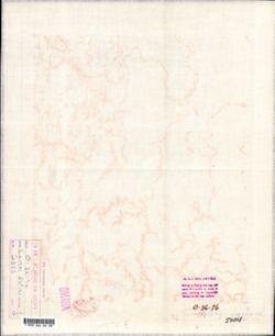
- Description:
- 1938
- Subject:
- Topical Subject: Maps, Topical Subject: Soviet Union, and Geographic Subject: Pola
- Publisher:
- Главное управление геодезии и картографии при СНК СССР
- Language:
- Russian
- Date Created:
- 1941
- Identifier:
- VAC9619-002179
- Genre:
- Topographic Maps and Military Maps
- Geographic Location:
- Coordinates: 57.6667, 31.5, 58, 32
- Related URL:
- DataCORE Dataset Download: https://datacore.iu.edu/concern/data_sets/0r967451s
- Abstract:
- Modern area represented: Пола (Pola), Novgorodskaya oblast, Russia
- Call Number:
- G7000 s100 .S7 sheet O-36-76
- Caption:
- Captured map and Для служебного пользования
- City:
- Пола (Pola)
- Copyright Holder:
- No Copyright - United States
- Country:
- СССР (USSR)
- State/Province:
- РСФСР (RSFSR) and Ленинградская область (Leningrad oblast)
- Physical Description:
- Scale: 1:100,000
- Persistent URL:
- http://purl.dlib.indiana.edu/iudl/images/VAC9619/VAC9619-002179
- Provenance:
- DMA Topographic Center, Army Map Service Library, OMAHA, Library of Congress Geography & Map Division
-
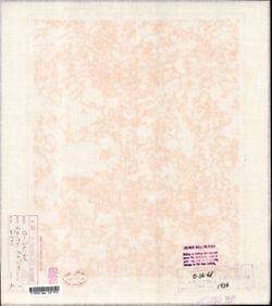
- Description:
- 1932
- Subject:
- Topical Subject: Maps, Topical Subject: Soviet Union, and Geographic Subject: Gorodtsy
- Publisher:
- Генеральный штаб Красной Армии
- Language:
- Russian
- Date Created:
- 1941
- Identifier:
- VAC9619-002178
- Genre:
- Topographic Maps and Military Maps
- Geographic Location:
- Coordinates: 57.6667, 30.5, 58, 31
- Related URL:
- DataCORE Dataset Download: https://datacore.iu.edu/concern/data_sets/qb98mg31f
- Abstract:
- Modern area represented: Городцы (Gorodtsy), Novgorodskaya oblast, Russia
- Call Number:
- G7000 s100 .S7 sheet O-36-74
- Caption:
- Для служебного пользования and Временное издание
- City:
- Городцы (Gorodtsy)
- Copyright Holder:
- No Copyright - United States
- Country:
- СССР (USSR)
- State/Province:
- Ленинградская область (Leningrad oblast) and РСФСР (RSFSR)
- Physical Description:
- Scale: 1:100,000
- Persistent URL:
- http://purl.dlib.indiana.edu/iudl/images/VAC9619/VAC9619-002178
- Provenance:
- DMA Topographic Center, Army Map Service Library, OMAHA, Library of Congress Geography & Map Division
-
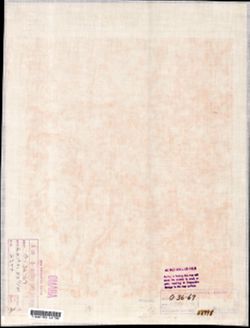
- Description:
- 1939
- Subject:
- Geographic Subject: Uglovka, Topical Subject: Soviet Union, and Topical Subject: Maps
- Publisher:
- Генеральный штаб Красной Армии
- Language:
- Russian
- Date Created:
- 1941
- Identifier:
- VAC9619-002152
- Genre:
- Topographic Maps and Military Maps
- Geographic Location:
- Coordinates: 58.0, 33.5, 58.3333, 34.0
- Related URL:
- DataCORE Dataset Download: https://datacore.iu.edu/concern/data_sets/wp988k694
- Abstract:
- Modern area represented: Угловка (Uglovka), Novgorodskaya oblast, Russia
- Call Number:
- G7000 s100 .S7 sheet O-36-68
- Caption:
- Captured map and Для служебного пользования
- City:
- Угловка (Uglovka)
- Copyright Holder:
- No Copyright - United States
- Country:
- СССР (USSR)
- State/Province:
- Калининская область (Kalinin oblast), Ленинградская область (Leningrad oblast), and РСФСР (RSFSR)
- Physical Description:
- Scale: 1:100,000
- Persistent URL:
- http://purl.dlib.indiana.edu/iudl/images/VAC9619/VAC9619-002152
- Provenance:
- DMA Topographic Center, Army Map Service Library, OMAHA, Library of Congress Geography & Map Division
-
- Description:
- 1939
- Subject:
- Topical Subject: Soviet Union, Geographic Subject: Shuya, and Topical Subject: Maps
- Publisher:
- Главное управление геодезии и картографии при СНК СССР
- Language:
- Russian
- Date Created:
- 1941
- Identifier:
- VAC9619-002151
- Genre:
- Topographic Maps and Military Maps
- Geographic Location:
- Coordinates: 58, 33, 58.3333, 33.5
- Related URL:
- DataCORE Dataset Download: https://datacore.iu.edu/concern/data_sets/hd76s078r
- Abstract:
- Modern area represented: Шуя (Shuya), Novgorodskaya oblast, Russia
- Call Number:
- G7000 s100 .S7 sheet O-36-67
- Caption:
- Captured map and Для служебного пользования
- City:
- Шуя (Shuya)
- Copyright Holder:
- No Copyright - United States
- Country:
- СССР (USSR)
- State/Province:
- РСФСР (RSFSR) and Ленинградская область (Leningrad oblast)
- Physical Description:
- Scale: 1:100,000
- Persistent URL:
- http://purl.dlib.indiana.edu/iudl/images/VAC9619/VAC9619-002151
- Provenance:
- DMA Topographic Center, Army Map Service Library, OMAHA, Library of Congress Geography & Map Division
-
- Description:
- 1938
- Subject:
- Topical Subject: Maps, Geographic Subject: Kresttsy, and Topical Subject: Soviet Union
- Publisher:
- Главное управление геодезии и картографии при СНК СССР
- Language:
- Russian
- Date Created:
- 1941
- Identifier:
- VAC9619-002150
- Genre:
- Topographic Maps and Military Maps
- Geographic Location:
- Coordinates: 58, 32.5, 58.3333, 33
- Related URL:
- DataCORE Dataset Download: https://datacore.iu.edu/concern/data_sets/mw22v617m
- Abstract:
- Modern area represented: Крестцы (Kresttsy), Novgorodskaya oblast, Russia
- Call Number:
- G7000 s100 .S7 sheet O-36-66
- Caption:
- Для служебного пользования
- City:
- Крестцы (Kresttsy)
- Copyright Holder:
- No Copyright - United States
- Country:
- СССР (USSR)
- State/Province:
- Ленинградская область (Leningrad oblast) and РСФСР (RSFSR)
- Physical Description:
- Scale: 1:100,000
- Persistent URL:
- http://purl.dlib.indiana.edu/iudl/images/VAC9619/VAC9619-002150
- Provenance:
- DMA Topographic Center, Army Map Service Library, OMAHA, Library of Congress Geography & Map Division
-
- Subject:
- Geographic Subject: Dubovitsy, Topical Subject: Soviet Union, and Topical Subject: Maps
- Publisher:
- Генеральный штаб Красной Армии
- Language:
- Russian
- Date Created:
- 1941
- Identifier:
- VAC9619-002148
- Genre:
- Topographic Maps and Military Maps
- Geographic Location:
- Coordinates: 58, 31, 58.3333, 31.5
- Related URL:
- DataCORE Dataset Download: https://datacore.iu.edu/concern/data_sets/7w62f8986
- Abstract:
- Modern area represented: Дубовицы (Dubovitsy), Novgorodskaya oblast, Russia
- Call Number:
- G7000 s100 .S7 sheet O-36-63
- Caption:
- Для служебного пользования
- City:
- Дубовицы (Dubovitsy)
- Copyright Holder:
- No Copyright - United States
- Country:
- СССР (USSR)
- State/Province:
- РСФСР (RSFSR) and Ленинградская область (Leningrad oblast)
- Physical Description:
- Scale: 1:100,000
- Persistent URL:
- http://purl.dlib.indiana.edu/iudl/images/VAC9619/VAC9619-002148
- Provenance:
- DMA Topographic Center, Army Map Service Library, Library of Congress G & M Division
-
- Description:
- 1939
- Subject:
- Topical Subject: Soviet Union, Geographic Subject: Moshenskoye, and Topical Subject: Maps
- Publisher:
- Главное управление геодезии и картографии при СНК СССР
- Language:
- Russian
- Date Created:
- 1941
- Identifier:
- VAC9619-002147
- Genre:
- Topographic Maps and Military Maps
- Geographic Location:
- Coordinates: 58.3333, 34.5, 58.6667, 35
- Related URL:
- DataCORE Dataset Download: https://datacore.iu.edu/concern/data_sets/8k71nh893
- Abstract:
- Modern area represented: Мошенское (Moshenskoye), Novgorodskaya oblast, Russia
- Call Number:
- G7000 s100 .S7 sheet O-36-58
- Caption:
- Captured map
- City:
- Мошенское (Moshenskoye)
- Copyright Holder:
- No Copyright - United States
- Country:
- СССР (USSR)
- State/Province:
- Ленинградская область (Leningrad oblast) and РСФСР (RSFSR)
- Physical Description:
- Scale: 1:100,000
- Persistent URL:
- http://purl.dlib.indiana.edu/iudl/images/VAC9619/VAC9619-002147
- Provenance:
- DMA Topographic Center, Army Map Service Library, OMAHA, Library of Congress Geography & Map Division
-
- Description:
- 1940
- Subject:
- Geographic Subject: Borovichi, Topical Subject: Soviet Union, and Topical Subject: Maps
- Publisher:
- Главное управление геодезии и картографии при СНК СССР
- Language:
- Russian
- Date Created:
- 1941
- Identifier:
- VAC9619-002146
- Genre:
- Topographic Maps and Military Maps
- Geographic Location:
- Coordinates: 58.3333, 33.5, 58.6667, 34
- Related URL:
- DataCORE Dataset Download: https://datacore.iu.edu/concern/data_sets/bg257f86p
- Abstract:
- Modern area represented: Боровичи (Borovichi), Novgorodskaya oblast, Russia
- Call Number:
- G7000 s100 .S7 sheet O-36-56
- Caption:
- Временное издание and Для служебного пользования
- City:
- Боровичи (Borovichi)
- Copyright Holder:
- No Copyright - United States
- Country:
- СССР (USSR)
- State/Province:
- РСФСР (RSFSR) and Ленинградская область (Leningrad oblast)
- Physical Description:
- Scale: 1:100,000
- Persistent URL:
- http://purl.dlib.indiana.edu/iudl/images/VAC9619/VAC9619-002146
- Provenance:
- DMA Topographic Center, Army Map Service Library, OMAHA, Library of Congress Geography & Map Division
-
- Description:
- 1938
- Subject:
- Geographic Subject: Viny, Topical Subject: Soviet Union, and Topical Subject: Maps
- Publisher:
- Главное управление геодезии и картографии при СНК СССР
- Language:
- Russian
- Date Created:
- 1941
- Identifier:
- VAC9619-002143
- Genre:
- Military Maps and Topographic Maps
- Geographic Location:
- Coordinates: 58.3333, 32, 58.6667, 32.5
- Related URL:
- DataCORE Dataset Download: https://datacore.iu.edu/concern/data_sets/0k225b79r
- Abstract:
- Modern area represented: Вины (Viny), Novgorodskaya oblast, Russia
- Call Number:
- G7000 s100 .S7 sheet O-36-53
- Caption:
- Временное издание and Для служебного пользования
- City:
- Вины (Viny)
- Copyright Holder:
- No Copyright - United States
- Country:
- СССР (USSR)
- State/Province:
- РСФСР (RSFSR) and Ленинградская область (Leningrad oblast)
- Physical Description:
- Scale: 1:100,000
- Persistent URL:
- http://purl.dlib.indiana.edu/iudl/images/VAC9619/VAC9619-002143
- Provenance:
- DMA Topographic Center, Army Map Service Library, Library of Congress G & M Division
-
- Description:
- 1937
- Subject:
- Geographic Subject: Proletariy, Topical Subject: Soviet Union, and Topical Subject: Maps
- Publisher:
- Главное управление геодезии и картографии при СНК СССР
- Language:
- Russian
- Date Created:
- 1941
- Identifier:
- VAC9619-002142
- Genre:
- Military Maps and Topographic Maps
- Geographic Location:
- Coordinates: 58.3333, 31.5, 58.6667, 32
- Related URL:
- DataCORE Dataset Download: https://datacore.iu.edu/concern/data_sets/qn59q473r
- Abstract:
- Modern area represented: Пролетарий (Proletariy), Novgorodskaya oblast, Russia
- Call Number:
- G7000 s100 .S7 sheet O-36-52
- Caption:
- Для служебного пользования
- City:
- Пролетарий (Proletariy)
- Copyright Holder:
- No Copyright - United States
- Country:
- СССР (USSR)
- State/Province:
- РСФСР (RSFSR) and Ленинградская область (Leningrad oblast)
- Physical Description:
- Scale: 1:100,000
- Persistent URL:
- http://purl.dlib.indiana.edu/iudl/images/VAC9619/VAC9619-002142
- Provenance:
- DMA Topographic Center, Army Map Service Library, OMAHA, Library of Congress Geography & Map Division
