
Search Constraints
You searched for:
Subject
Topical Subject: Soviet Union
Remove constraint Subject: Topical Subject: Soviet Union
« Previous |
1 - 20 of 4,131
|
Next »
Search Results
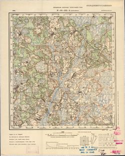
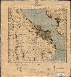
-
- Description:
- 1890
- Subject:
- Topical Subject: Maps, Geographic Subject: Kersleti, and Topical Subject: Soviet Union
- Publisher:
- Управление военных топографов
- Language:
- Russian
- Date Created:
- 1900
- Identifier:
- VAC9619-001670
- Genre:
- Topographic Maps and Military Maps
- Geographic Location:
- Coordinates: 59, 23, 59.167, 23.25
- Related URL:
- Catalog URL: http://iucat.iu.edu/catalog/5020131 and Download GeoTIFF: https://drive.google.com/open?id=1hbDmzQAiMfBU_L1SZkfcXjJgwchyfKjV
- Abstract:
- Modern area represented: Kersleti, Lääne county, Estonia
- Call Number:
- G7000 s50 .S68 sheet O-34-35-B
- City:
- Керслет (Kersleti)
- Copyright Holder:
- No Copyright - United States
- Country:
- Эстония (Estonia)
- Physical Description:
- Scale: 1:50,000
- Persistent URL:
- http://purl.dlib.indiana.edu/iudl/images/VAC9619/VAC9619-001670
- Provenance:
- DMA Topographic Center, OMAHA, Geographic Names Branch, Army Map Service Library, Library of Congress Geography & Map Division
-

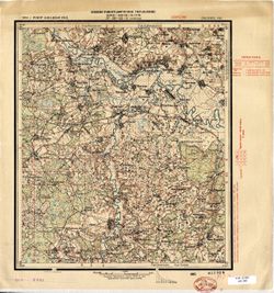
- Description:
- 1914
- Subject:
- Topical Subject: Soviet Union, Topical Subject: Maps, and Geographic Subject: Zakhonye
- Publisher:
- Управление военных топографов
- Language:
- Russian
- Date Created:
- 1925
- Identifier:
- VAC9619-001851
- Genre:
- Military Maps and Topographic Maps
- Geographic Location:
- Coordinates: 58.833, 29.25, 59, 29.5
- Related URL:
- Download GeoTIFF: https://drive.google.com/open?id=13eq_cnnXj2y4sziLGe95t8EKFYpjTMdS and Catalog URL: http://iucat.iu.edu/catalog/5020131
- Abstract:
- Modern area represented: Zakhonye, Russia
- Call Number:
- G7000 s50 .S68 sheet O-35-47-B
- Caption:
- Не подлежит оглашению,Captured map
- City:
- Захоноье (Zakhonye)
- Copyright Holder:
- No Copyright - United States
- Country:
- СССР (USSR)
- State/Province:
- РСФСР (RSFSR) and Ленинградская область (Leningrad oblast)
- Physical Description:
- Scale: 1:50,000
- Persistent URL:
- http://purl.dlib.indiana.edu/iudl/images/VAC9619/VAC9619-001851
- Provenance:
- Army Map Service Library, OMAHA, Library of Congress Geography & Map Division
-
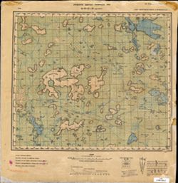
- Description:
- 1936
- Subject:
- Geographic Subject: Ozero Vadozero, Topical Subject: Soviet Union, and Topical Subject: Maps
- Publisher:
- Управление военных топографов РККА
- Language:
- Russian
- Identifier:
- VAC9619-002568
- Genre:
- Topographic Maps and Military Maps
- Geographic Location:
- Coordinates: 67, 31, 67.333, 32
- Related URL:
- Download GeoTIFF: https://drive.google.com/file/d/1tQnrCvTr4D-7FlG7pcuATUnFg3cTE22e/view?usp=sharing and Catalog URL: https://iucat.iu.edu/catalog/5020129
- Abstract:
- Modern area represented: Ozero Vadozero, Murmansk oblast, Russia
- Call Number:
- G7000 s100 .S7 sheet Q-36-27
- Caption:
- Не подлежит оглашению,Captured map
- City:
- Вад-озеро (Ozero Vadozero)
- Copyright Holder:
- No Copyright - United States
- Country:
- СССР (USSR)
- State/Province:
- Ленинградская область (Leningrad oblast), РСФСР (RSFSR), and Карельская АССР (Karelian Autonomous Soviet Socialist Republic)
- Physical Description:
- Scale: 1:100,000
- Persistent URL:
- http://purl.dlib.indiana.edu/iudl/images/VAC9619/VAC9619-002568
- Provenance:
- DMA Topographic Center, Army Map Service Library, OMAHA
-
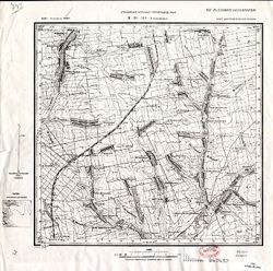
- Description:
- 1928
- Subject:
- Topical Subject: Soviet Union, Topical Subject: Maps, and Geographic Subject: Maryanovka
- Publisher:
- Управление военных топографов РККА
- Language:
- Russian
- Date Created:
- 1930
- Identifier:
- VAC9619-001170
- Genre:
- Military Maps and Topographic Maps
- Geographic Location:
- Coordinates: 48.167, 33.5, 48.333, 33.75
- Related URL:
- Catalog URL: http://iucat.iu.edu/catalog/5020131 and Download GeoTIFF: https://drive.google.com/open?id=1TcoQgF6oEgeExR6LG-eMJlucz0cQ0qyl
- Abstract:
- Modern area represented: Maryanovka, Dnipropetrovsk oblast, Ukraine
- Call Number:
- GM G7000 S50 .S68 M-36-140-A
- Caption:
- Не подлежит оглашению
- City:
- Марьяновка (Maryanovka)
- Copyright Holder:
- No Copyright - United States
- Country:
- СССР (USSR)
- State/Province:
- Днепропетровская область (Dnipropetrovsk oblast) and Украинская ССР (Ukrainian Soviet Socialist Republic)
- Physical Description:
- Scale: 1:50,000
- Persistent URL:
- http://purl.dlib.indiana.edu/iudl/images/VAC9619/VAC9619-001170
- Provenance:
- DMA Topographic Center, Army Map Service Library, OMAHA, Library of Congress Geography & Map Division
-
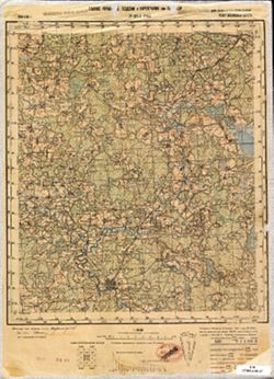
- Subject:
- Topical Subject: Soviet Union, Topical Subject: Maps, and Geographic Subject: Ruza
- Publisher:
- Главное Управление Геодезии и Картографии при СНК СССР
- Language:
- Russian
- Date Created:
- 1941
- Identifier:
- VAC9619-001988
- Genre:
- Military Maps and Topographic Maps
- Geographic Location:
- Coordinates: 55.6667, 36, 56, 36.5
- Related URL:
- Download GeoTIFF: https://drive.google.com/open?id=183z014zc6Fo65VnpwC5QfH0wkSz1d_qH and Catalog URL: https://iucat.iu.edu/catalog/5020129
- Abstract:
- Modern area represented: Ruza, Moscow oblast, Russia
- Call Number:
- G7000 s100 .S7 sheet N-37-1
- Caption:
- Для служебного пользования
- City:
- Руза (Ruza)
- Copyright Holder:
- No Copyright - United States
- Country:
- СССР (USSR)
- State/Province:
- Московская область (Moscow oblast) and РСФСР (RSFSR)
- Physical Description:
- Scale: 1:100,000
- Persistent URL:
- http://purl.dlib.indiana.edu/iudl/images/VAC9619/VAC9619-001988
- Provenance:
- DMA Topographic Center, Army Map Service Library, Geographic Names Branch, OMAHA
-
- Description:
- 1936
- Subject:
- Topical Subject: Maps, Topical Subject: Soviet Union, and Geographic Subject: Dubrova
- Publisher:
- Управление военных топографов РККА
- Language:
- Russian
- Identifier:
- VAC9619-000787
- Genre:
- Military Maps and Topographic Maps
- Geographic Location:
- Coordinates: 52.5, 29.25, 52.667, 29.5
- Related URL:
- Download GeoTIFF: https://drive.google.com/open?id=1exPyUC6LvIjyDpQjacJC9PC4HKAjtEPc and Catalog URL: http://iucat.iu.edu/catalog/5020131
- Abstract:
- Modern area represented: Dubrova, Homyel oblast, Belarus
- Call Number:
- G7000 s50 .s68 sheet N-35-131-B
- Caption:
- Не подлежит оглашению
- City:
- Дуброва (Dubrova)
- Copyright Holder:
- No Copyright - United States
- Country:
- СССР (USSR)
- State/Province:
- Белорусская ССР (Byelorussian Soviet Socialist Republic)
- Physical Description:
- Scale: 1:50,000
- Persistent URL:
- http://purl.dlib.indiana.edu/iudl/images/VAC9619/VAC9619-000787
- Provenance:
- M. I. Map Library, G000-30, GS, RA, OMAHA, Library of Congress Geography & Map Division, Army Map Service Library
-
- Description:
- 1936
- Subject:
- Topical Subject: Soviet Union, Geographic Subject: Pukhavichy, and Topical Subject: Maps
- Publisher:
- Управление военных топографов РККА
- Language:
- Russian
- Identifier:
- VAC9619-000652
- Genre:
- Topographic Maps and Military Maps
- Geographic Location:
- Coordinates: 53.5, 28.25, 53.667, 28.5
- Related URL:
- Download GeoTIFF: https://drive.google.com/open?id=1tc9WqkzkXMe1W75jNrY4b1YDitDO7sZs and Catalog URL: http://iucat.iu.edu/catalog/5020131
- Abstract:
- Modern area represented: Pukhavichy, Minsk oblast, Belarus
- Call Number:
- G7000 s50 .S68 sheet N-35-93-B
- Caption:
- Не подлежит оглашению,Captured map
- City:
- Пуховичи (Puhovichi)
- Copyright Holder:
- No Copyright - United States
- Country:
- СССР (USSR)
- State/Province:
- Белорусская ССР (Byelorussian Soviet Socialist Republic)
- Physical Description:
- Scale: 1:50,000
- Persistent URL:
- http://purl.dlib.indiana.edu/iudl/images/VAC9619/VAC9619-000652
- Provenance:
- Army Map Service Library, OMAHA, Library of Congress Geography & Map Division
-
- Description:
- 1936
- Subject:
- Topical Subject: Soviet Union, Geographic Subject: Zhitkovitsy, and Topical Subject: Maps
- Publisher:
- Управление военных топографов РККА
- Language:
- Russian
- Identifier:
- VAC9619-000024
- Genre:
- Military Maps and Topographic Maps
- Geographic Location:
- Coordinates: 58.667, 28.75, 58.833, 29
- Related URL:
- Catalog URL: http://iucat.iu.edu/catalog/5020131 and Download GeoTIFF: https://drive.google.com/open?id=1gAuIgkJWW_VNrb5GinG0F75CBMhYwjCr
- Abstract:
- Modern area represented: Zhitkovitsy, Russia
- Call Number:
- G7000 s50 .S68 sheet O-35-46-D
- Caption:
- Не подлежит оглашению ,Captured map,Duplicate
- City:
- Житковичи (Zhitkovitsy)
- Copyright Holder:
- No Copyright - United States
- Country:
- СССР (USSR)
- State/Province:
- РСФСР (RSFSR) and Ленинградская область (Leningrad oblast)
- Physical Description:
- Scale: 1:50,000
- Persistent URL:
- http://purl.dlib.indiana.edu/iudl/images/VAC9619/VAC9619-000024
- Provenance:
- Army Map Service Library, OMAHA, Library of Congress Geography & Map Division
-
- Subject:
- Topical Subject: Soviet Union, Topical Subject: Maps, and Geographic Subject: Suur-Selänpää
- Publisher:
- Генеральный штаб РККА
- Language:
- Russian
- Date Created:
- 1940
- Identifier:
- VAC9619-002379
- Genre:
- Military Maps and Topographic Maps
- Geographic Location:
- Coordinates: 61.0, 26.5, 61.333333, 27.0
- Related URL:
- Catalog URL: https://iucat.iu.edu/catalog/5020129 and Download GeoTIFF: https://drive.google.com/file/d/1IphV-fyNP5DuxyjjFppqeaSfcSPZJMh5/view?usp=sharing
- Abstract:
- Modern area represented: Suur-Selänpää, Kymenlaakso, Finland
- Call Number:
- G7000 s100 .S7 sheet P-35-102
- City:
- Селянпяя (Selänpää)
- Copyright Holder:
- No Copyright - United States
- Country:
- Финляндия (Finland)
- Physical Description:
- Scale: 1:100,000
- Persistent URL:
- http://purl.dlib.indiana.edu/iudl/images/VAC9619/VAC9619-002379
- Provenance:
- DMA Topographic Center, Army Map Service Library, OMAHA
-
- Description:
- 1936
- Subject:
- Topical Subject: Soviet Union, Topical Subject: Maps, and Geographic Subject: Valosavіchy
- Publisher:
- Управление военных топографов РККА
- Language:
- Russian
- Identifier:
- VAC9619-000785
- Genre:
- Military Maps and Topographic Maps
- Geographic Location:
- Coordinates: 52.5, 29, 52.667, 29.25
- Related URL:
- Download GeoTIFF: https://drive.google.com/open?id=1-0JtGuoRcAQOMue9zKRY1H90BFVHsJ9M and Catalog URL: http://iucat.iu.edu/catalog/5020131
- Abstract:
- Modern area represented: Valosavіchy, Homyel oblast, Belarus
- Call Number:
- G7000 s50 .s68 sheet N-35-131-A
- Caption:
- Не подлежит оглашению
- City:
- Волосовичи (Volosovichi)
- Copyright Holder:
- No Copyright - United States
- Country:
- СССР (USSR)
- State/Province:
- Белорусская ССР (Byelorussian Soviet Socialist Republic)
- Physical Description:
- Scale: 1:50,000
- Persistent URL:
- http://purl.dlib.indiana.edu/iudl/images/VAC9619/VAC9619-000785
- Provenance:
- M. I. Map Library, G000-30, GS, RA, Library of Congress Geography & Map Division
-
- Description:
- 1924
- Subject:
- Geographic Subject: Usvyatye, Topical Subject: Maps, and Topical Subject: Soviet Union
- Publisher:
- Военно-топографическое управление
- Language:
- Russian
- Identifier:
- VAC9619-001311
- Genre:
- Topographic Maps and Military Maps
- Geographic Location:
- Coordinates: 54.833, 33, 55, 33.25
- Related URL:
- Download GeoTIFF: https://drive.google.com/open?id=1AaD9cb-yeLx9Q9q3fqX2yj9TKMto0b91 and Catalog URL: http://iucat.iu.edu/catalog/5020131
- Abstract:
- Modern area represented: Usvyatye, Smolensk oblast, Russia
- Call Number:
- GM G7000 S50 .S68 N-36-43-A
- Caption:
- Секретно
- City:
- Усвятье (Usvyatye)
- Copyright Holder:
- No Copyright - United States
- Country:
- СССР (USSR)
- State/Province:
- РСФСР (RSFSR) and Западная область (Western oblast)
- Physical Description:
- Scale: 1:50,000
- Persistent URL:
- http://purl.dlib.indiana.edu/iudl/images/VAC9619/VAC9619-001311
- Provenance:
- Army Map Service Library, Library of Congress G & M Division, OMAHA
-
- Description:
- 1909
- Subject:
- Topical Subject: Soviet Union, Geographic Subject: Yarun, and Topical Subject: Maps
- Publisher:
- Управление военных топографов РККА
- Language:
- Russian
- Identifier:
- VAC9619-000223
- Genre:
- Topographic Maps and Military Maps
- Geographic Location:
- Coordinates: 50.5, 27.25, 50.667, 27.5
- Related URL:
- Download GeoTIFF: https://drive.google.com/open?id=17KmDaXN8x05zM3z-hw5VoHIxZVWjOqXH and Catalog URL: http://iucat.iu.edu/catalog/5020131
- Abstract:
- Modern area represented: Yarun, Zhytomyr oblast, Ukraine
- Call Number:
- G7000 s50 .S68 sheet M-35-55-B
- Caption:
- Не подлежит оглашению
- City:
- Ярунь (Yarun)
- Copyright Holder:
- No Copyright - United States
- Country:
- СССР (USSR)
- State/Province:
- Украинская ССР (Ukrainian Soviet Socialist Republic) and Киевская область (Kyiv oblast)
- Physical Description:
- Scale: 1:50,000
- Persistent URL:
- http://purl.dlib.indiana.edu/iudl/images/VAC9619/VAC9619-000223
- Provenance:
- DMA Topographic Center, Army Map Service Library, OMAHA, Library of Congress Geography & Map Division
-

- Description:
- 1928
- Subject:
- Geographic Subject: Surazh, Topical Subject: Soviet Union, and Topical Subject: Maps
- Publisher:
- Генеральный штаб Красной Армии
- Language:
- Russian
- Date Created:
- 1941
- Identifier:
- VAC9619-001977
- Genre:
- Topographic Maps and Military Maps
- Geographic Location:
- Coordinates: 53, 32, 53.3333, 32.5
- Related URL:
- Catalog URL: https://iucat.iu.edu/catalog/5020129 and Download GeoTIFF: https://drive.google.com/open?id=1beMyaj-VgbNaVBKPEMNn15PuoGtx7M9s
- Abstract:
- Modern area represented: Surazh, Bryansk oblast, Russia
- Call Number:
- G7000 s100 .S7 sheet N-36-101
- City:
- Сураж (Surazh)
- Copyright Holder:
- No Copyright - United States
- Country:
- СССР (USSR)
- State/Province:
- Могилевская область (Mogilev oblast), Белорусская ССР (Byelorussian Soviet Socialist Republic), РСФСР (RSFSR), and Орловская область (Oryol oblast)
- Physical Description:
- Scale: 1:100,000
- Persistent URL:
- http://purl.dlib.indiana.edu/iudl/images/VAC9619/VAC9619-001977
- Provenance:
- DMA Topographic Center, Army Map Service Library
-
- Description:
- 1936
- Subject:
- Geographic Subject: Voloshovo, Topical Subject: Maps, and Topical Subject: Soviet Union
- Publisher:
- Генеральный штаб РККА
- Language:
- Russian
- Date Created:
- 1937
- Identifier:
- VAC9619-001852
- Genre:
- Topographic Maps and Military Maps
- Geographic Location:
- Coordinates: 58.667, 29.25, 58.833, 29.5
- Related URL:
- Catalog URL: http://iucat.iu.edu/catalog/5020131 and Download GeoTIFF: https://drive.google.com/open?id=1pHva-PGBr0hpKzHfPowYax7ILfiz6wiD
- Abstract:
- Modern area represented: Voloshovo, Russia
- Call Number:
- G7000 s50 .S68 sheet O-35-47-D
- Caption:
- Не подлежит оглашению
- City:
- Волошово (Voloshovo)
- Copyright Holder:
- No Copyright - United States
- Country:
- СССР (USSR)
- State/Province:
- РСФСР (RSFSR) and Ленинградская область (Leningrad oblast)
- Physical Description:
- Scale: 1:50,000
- Persistent URL:
- http://purl.dlib.indiana.edu/iudl/images/VAC9619/VAC9619-001852
- Provenance:
- Army Map Service Library, OMAHA, Library of Congress Geography & Map Division
-
- Description:
- 1875
- Subject:
- Geographic Subject: Belgorod-Dnestrovskiy, Topical Subject: Soviet Union, and Topical Subject: Maps
- Publisher:
- Управление военных топографов РККА
- Language:
- Russian
- Date Created:
- 1929
- Identifier:
- VAC9619-001915
- Genre:
- Topographic Maps and Military Maps
- Geographic Location:
- Coordinates: 46, 30, 46.3333, 30.5
- Related URL:
- Catalog URL: https://iucat.iu.edu/catalog/5020129 and Download GeoTIFF: https://drive.google.com/file/d/1xTaeC4RlvKqjCHGORBzShnm74gH5QF17/view?usp=sharing
- Abstract:
- Modern area represented: Belgorod-Dnestrovskiy, Odessa oblast, Ukraine
- Call Number:
- G7000 s100 .S7 sheet L-36-61
- Caption:
- Не подлежит оглашению
- City:
- Аккерман (Akkerman)
- Copyright Holder:
- No Copyright - United States
- Country:
- СССР (USSR)
- State/Province:
- Бессарабия (Bessarabia) and Украинская ССР (Ukrainian Soviet Socialist Republic)
- Physical Description:
- Scale: 1:100,000
- Persistent URL:
- http://purl.dlib.indiana.edu/iudl/images/VAC9619/VAC9619-001915
- Provenance:
- DMA Topographic Center, Army Map Service Library, OMAHA
-
- Subject:
- Topical Subject: Maps, Topical Subject: Soviet Union, and Geographic Subject: Povenets
- Publisher:
- Itä-Karjalan kartasto
- Language:
- Russian
- Identifier:
- VAC9619-002500
- Genre:
- Topographic Maps and Military Maps
- Geographic Location:
- Coordinates: 62.667, 34.5, 63, 35
- Related URL:
- Download GeoTIFF: https://drive.google.com/file/d/11CTekGtzM6PCJt9U4WWXhs6PTTfpZKv2/view?usp=sharing and Catalog URL: https://iucat.iu.edu/catalog/5020129
- Abstract:
- Modern area represented: Повенец (Povenets), Медвежьегорский район (Medvezhyegorsky District), Republic of Karelia, Russia
- Call Number:
- G7000 s100 .S7 sheet P-36-46
- Caption:
- Captured map
- City:
- Повенец (Povenets)
- Copyright Holder:
- No Copyright - United States
- Physical Description:
- Scale: 1:100,000
- Persistent URL:
- http://purl.dlib.indiana.edu/iudl/images/VAC9619/VAC9619-002500
- Provenance:
- DMA Topographic Center, Army Map Service Library, OMAHA
-
- Description:
- 1936
- Subject:
- Topical Subject: Soviet Union, Geographic Subject: Osipovichi, and Topical Subject: Maps
- Publisher:
- Генеральный штаб Красной Армии
- Language:
- Russian
- Identifier:
- VAC9619-004110
- Genre:
- Topographic Maps and Military Maps
- Geographic Location:
- Coordinates: 53, 28.5, 53.333, 29
- Related URL:
- Catalog URL: https://iucat.iu.edu/catalog/5020129 and Download GeoTIFF: https://drive.google.com/file/d/1QHztwVY5BfNd2v6YqGnUlSEcglWhRTrs/view?usp=sharing
- Abstract:
- Modern area represented: Osipovichi, Belarus
- Call Number:
- G7000 s100 .S7 sheet N-35-106
- Caption:
- Не подлежит оглашению
- City:
- Осиповичи (Osipovichi)
- Copyright Holder:
- No Copyright - United States
- Country:
- СССР (USSR)
- State/Province:
- Полесская область (Polesia oblast), Могилевская область (Mogilev oblast), Белорусская ССР (Byelorussian Soviet Socialist Republic), and Минская область (Mins...
- Physical Description:
- Scale: 1:100,000
- Persistent URL:
- http://purl.dlib.indiana.edu/iudl/images/VAC9619/VAC9619-004110
- Provenance:
- DMA Topographic Center, Army Map Service Library, OMAHA
-
- Description:
- 1927
- Subject:
- Geographic Subject: Nelidovo, Topical Subject: Soviet Union, and Topical Subject: Maps
- Publisher:
- Военно-топографическое управление
- Language:
- Russian
- Identifier:
- VAC9619-003499
- Genre:
- Military Maps and Topographic Maps
- Geographic Location:
- Coordinates: 56.167, 32.75, 56.333, 33
- Related URL:
- Download GeoTIFF: https://drive.google.com/file/d/1lyldTXRTAWh4xkvxGY4qHYiAm3I1vIe8/view?usp=sharing and Catalog URL: http://iucat.iu.edu/catalog/5020131
- Abstract:
- Modern area represented: Нелидово (Nelidovo), Tverskaya oblast, Russia
- Call Number:
- G7000 s50 .S68 sheet O-36-138-B
- Caption:
- Секретно
- City:
- Нелидово (Nelidovo)
- Copyright Holder:
- No Copyright - United States
- Country:
- СССР (USSR)
- State/Province:
- РСФСР (RSFSR) and Западная область (Western oblast)
- Physical Description:
- Scale: 1:50,000
- Persistent URL:
- http://purl.dlib.indiana.edu/iudl/images/VAC9619/VAC9619-003499
- Provenance:
- Army Map Service Library, OMAHA, Library of Congress Geography & Map Division
-
- Subject:
- Topical Subject: Maps, Geographic Subject: Ostrava, and Topical Subject: Soviet Union
- Publisher:
- Генеральный штаб РККА
- Language:
- Russian
- Identifier:
- VAC9619-002870
- Genre:
- Topographic Maps and Military Maps
- Geographic Location:
- Coordinates: 49.667, 18, 50, 18.5
- Related URL:
- Catalog URL: https://iucat.iu.edu/catalog/5020129 and Download GeoTIFF: https://drive.google.com/file/d/1OjvHezWlaQqX0XjfRTSy9iu_7Zy4fWVy/view?usp=sharing
- Abstract:
- Modern area represented: Ostrava, Moravskoslezský region, Czech Republic
- Call Number:
- G7000 s100 .S7 sheet M-34-73
- City:
- Морав. Острава (Moravian Ostrava)
- Copyright Holder:
- No Copyright - United States
- Country:
- Германия (Germany) and Чехословакия (Czechoslovakia)
- Physical Description:
- Scale: 1:100,000
- Persistent URL:
- http://purl.dlib.indiana.edu/iudl/images/VAC9619/VAC9619-002870
- Provenance:
- DMA Topographic Center, Army Map Service Library, OMAHA
-

- Description:
- 1938
- Subject:
- Topical Subject: Maps, Geographic Subject: Krasnogvardeyskoe, and Topical Subject: Soviet Union
- Publisher:
- Главное управление геодезии и картографии при СНК СССР
- Language:
- Russian
- Date Created:
- 1941
- Identifier:
- VAC9619-002343
- Genre:
- Topographic Maps and Military Maps
- Geographic Location:
- Coordinates: 45.667, 41.5, 46, 42
- Related URL:
- Download GeoTIFF: https://drive.google.com/file/d/1AVr-cwCpH2TyChEw-jxKdVkFJnNQ8ff2/view?usp=sharing and Catalog URL: https://iucat.iu.edu/catalog/5020129
- Abstract:
- Modern area represented: Krasnogvardeyskoe, Stavropol kray, Russia
- Call Number:
- G7000 s100 .S7 sheet L-37-84
- Caption:
- Для служебного пользования
- City:
- Молотовское (Molotovskoe)
- Copyright Holder:
- No Copyright - United States
- Country:
- СССР (USSR)
- State/Province:
- Орджоникидзевский край (Ordzhonikidze kray), Калмыцкая АССР (Kalmyk Autonomous Soviet Socialist Republic), Ростовская область (Rostov oblast), and РСФСР (RSFSR)
- Physical Description:
- Scale: 1:100,000
- Persistent URL:
- http://purl.dlib.indiana.edu/iudl/images/VAC9619/VAC9619-002343
- Provenance:
- DMA Topographic Center, Army Map Service Library, OMAHA
