
Search Constraints
You searched for:
State/Province
Калининская область (Kalinin oblast)
Remove constraint State/Province: Калининская область (Kalinin oblast)
State/Province
РСФСР (RSFSR)
Remove constraint State/Province: РСФСР (RSFSR)
Search Results
-
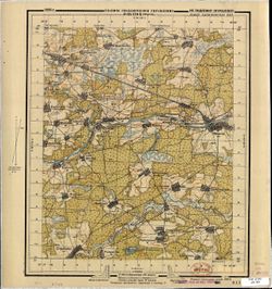
- Description:
- 1926
- Subject:
- Topical Subject: Maps, Topical Subject: Soviet Union, and Geographic Subject: Mednoye
- Publisher:
- Главное геодезическое управление
- Language:
- Russian
- Identifier:
- VAC9619-002903
- Genre:
- Military Maps and Topographic Maps
- Geographic Location:
- Coordinates: 56.833, 35.25, 57, 35.5
- Related URL:
- Catalog URL: http://iucat.iu.edu/catalog/5020131 and Download GeoTIFF: https://drive.google.com/file/d/1kG4LjC-4jz5MtXdj3pNyt9ECkdcWfm5D/view?usp=sharing
- Abstract:
- Modern area represented: Медное (Mednoye), Tverskaya oblast, Russia
- Call Number:
- GM G7000 s50 .S68 sheet O-36-119-B
- Caption:
- Не подлежит оглашению
- City:
- Медное (Mednoye)
- Copyright Holder:
- No Copyright - United States
- Country:
- СССР (USSR)
- State/Province:
- РСФСР (RSFSR) and Калининская область (Kalinin oblast)
- Physical Description:
- Scale: 1:50,000
- Persistent URL:
- http://purl.dlib.indiana.edu/iudl/images/VAC9619/VAC9619-002903
- Provenance:
- Library of Congress Geography & Map Division
-
- Subject:
- Topical Subject: Maps, Topical Subject: Soviet Union, and Geographic Subject: Yegorye
- Publisher:
- Генеральный штаб Красной Армии
- Language:
- Russian
- Date Created:
- 1941
- Identifier:
- VAC9619-003060
- Genre:
- Military Maps and Topographic Maps
- Geographic Location:
- Coordinates: 55.667, 33, 56, 33.5
- Related URL:
- Catalog URL: https://iucat.iu.edu/catalog/5020129 and Download GeoTIFF: https://drive.google.com/file/d/1gt8xpdmzh68_peTcl-qX2jhYC26ZFJy_/view?usp=sharing
- Abstract:
- Modern area represented: Yegorye, Tver oblast, Russia
- Call Number:
- G7000 s100 .S7 sheet N-36-7
- Caption:
- Captured map
- City:
- Егорье (Yegorye)
- Copyright Holder:
- No Copyright - United States
- Country:
- СССР (USSR)
- State/Province:
- Смоленская область (Smolensk oblast), Калининская область (Kalinin oblast), and РСФСР (RSFSR)
- Physical Description:
- Scale: 1:100,000
- Persistent URL:
- http://purl.dlib.indiana.edu/iudl/images/VAC9619/VAC9619-003060
- Provenance:
- DMA Topographic Center, Army Map Service Library, OMAHA, Heeresplankammer Auslandskartenarchiv
-
- Description:
- 1938
- Subject:
- Topical Subject: Maps, Topical Subject: Soviet Union, and Geographic Subject: Gavrilovo
- Publisher:
- Генеральный штаб Красной Армии
- Language:
- Russian
- Date Created:
- 1941
- Identifier:
- VAC9619-003061
- Genre:
- Military Maps and Topographic Maps
- Geographic Location:
- Coordinates: 55.667, 33.5, 56, 34
- Related URL:
- Catalog URL: https://iucat.iu.edu/catalog/5020129 and Download GeoTIFF: https://drive.google.com/file/d/14f1CH5OTuVaTK9ObB7G3OzT7AgXacQ9t/view?usp=sharing
- Abstract:
- Modern area represented: Гаврилово (Gavrilovo), Smolenskaya oblast, Russia
- Call Number:
- G7000 s100 .S7 sheet N-36-8
- City:
- Гаврилово (Gavrilovo)
- Copyright Holder:
- No Copyright - United States
- Country:
- СССР (USSR)
- State/Province:
- РСФСР (RSFSR), Смоленская область (Smolensk oblast), and Калининская область (Kalinin oblast)
- Physical Description:
- Scale: 1:100,000
- Persistent URL:
- http://purl.dlib.indiana.edu/iudl/images/VAC9619/VAC9619-003061
- Provenance:
- DMA Topographic Center, Army Map Service Library, OMAHA, Geographic Names Branch
-
- Description:
- 1939
- Subject:
- Geographic Subject: Sychevka, Topical Subject: Maps, and Topical Subject: Soviet Union
- Publisher:
- Генеральный штаб Красной Армии
- Language:
- Russian
- Date Created:
- 1941
- Identifier:
- VAC9619-003062
- Genre:
- Topographic Maps and Military Maps
- Geographic Location:
- Coordinates: 55.667, 34, 56, 34.5
- Related URL:
- Catalog URL: https://iucat.iu.edu/catalog/5020129 and Download GeoTIFF: https://drive.google.com/file/d/1gblwoAOQEZjmkqeDb6dK1pp3mPvMc0h4/view?usp=sharing
- Abstract:
- Modern area represented: Сычевка (Sychevka), Smolenskaya oblast, Russia
- Call Number:
- G7000 s100 .S7 sheet N-36-9
- Caption:
- Captured map
- City:
- Сычевка (Sychevka)
- Copyright Holder:
- No Copyright - United States
- Country:
- СССР (USSR)
- State/Province:
- Калининская область (Kalinin oblast), РСФСР (RSFSR), and Смоленская область (Smolensk oblast)
- Physical Description:
- Scale: 1:100,000
- Persistent URL:
- http://purl.dlib.indiana.edu/iudl/images/VAC9619/VAC9619-003062
- Provenance:
- DMA Topographic Center, Army Map Service Library, OMAHA, Auswärtiges Amt. Geographischer Dienst
-
- Description:
- 1939
- Subject:
- Topical Subject: Soviet Union, Topical Subject: Maps, and Geographic Subject: Shuvayevo
- Publisher:
- Главное управление геодезии и картографии при СНК СССР
- Language:
- Russian
- Date Created:
- 1941
- Identifier:
- VAC9619-002891
- Genre:
- Topographic Maps and Military Maps
- Geographic Location:
- Coordinates: 56.833, 33, 57, 33.25
- Related URL:
- Download GeoTIFF: https://drive.google.com/file/d/13FWxkADRE7fKlwOO1oh0LeFe8xTQPSzX/view?usp=sharing and Catalog URL: http://iucat.iu.edu/catalog/5020131
- Abstract:
- Modern area represented: Шуваево (Shuvayevo), Tverskaya oblast, Russia
- Call Number:
- GM G7000 s50 .S68 sheet O-36-115-A
- Caption:
- Для служебного пользования
- City:
- Шуваево (Shuvayevo)
- Copyright Holder:
- No Copyright - United States
- Country:
- СССР (USSR)
- State/Province:
- Калининская область (Kalinin oblast) and РСФСР (RSFSR)
- Physical Description:
- Scale: 1:50,000
- Persistent URL:
- http://purl.dlib.indiana.edu/iudl/images/VAC9619/VAC9619-002891
- Provenance:
- DMA Topographic Center, Army Map Service Library, OMAHA, Library of Congress Geography & Map Division
-
- Description:
- 1929
- Subject:
- Geographic Subject: Silagino, Topical Subject: Soviet Union, and Topical Subject: Maps
- Publisher:
- Управление военных топографов РККА
- Language:
- Russian
- Identifier:
- VAC9619-002882
- Genre:
- Military Maps and Topographic Maps
- Geographic Location:
- Coordinates: 56.833, 31.25, 57, 31.5
- Related URL:
- Download GeoTIFF: https://drive.google.com/file/d/1fc97oZxgWZchGPVDED4ZQ1_DTn8S_etO/view?usp=sharing and Catalog URL: http://iucat.iu.edu/catalog/5020131
- Abstract:
- Modern area represented: Силагино (Silagino), Novgorodskaya oblast, Russia
- Call Number:
- GM G7000 s50 .S68 sheet O-36-111-B
- Caption:
- Не подлежит оглашению and Captured map
- City:
- Силагино (Silagino)
- Copyright Holder:
- No Copyright - United States
- Country:
- СССР (USSR)
- State/Province:
- Калининская область (Kalinin oblast) and РСФСР (RSFSR)
- Physical Description:
- Scale: 1:50,000
- Persistent URL:
- http://purl.dlib.indiana.edu/iudl/images/VAC9619/VAC9619-002882
- Provenance:
- Army Map Service Library, OMAHA, Library of Congress Geography & Map Division
-
- Description:
- 1929
- Subject:
- Geographic Subject: Podberez’ye, Topical Subject: Soviet Union, and Topical Subject: Maps
- Publisher:
- Управление военных топографов РККА
- Language:
- Russian
- Identifier:
- VAC9619-002877
- Genre:
- Topographic Maps and Military Maps
- Geographic Location:
- Coordinates: 56.833, 30.5, 57, 30.75
- Related URL:
- Catalog URL: http://iucat.iu.edu/catalog/5020131 and Download GeoTIFF: https://drive.google.com/file/d/1CsuZEkuQ9Mj-qpTeHmhi6hfXultSLvV3/view?usp=sharing
- Abstract:
- Modern area represented: Подберезье (Podberez’ye), Pskovskaya oblast, Russia
- Call Number:
- GM G7000 s50 .S68 sheet O-36-110-A
- Caption:
- Captured map and Не подлежит оглашению
- City:
- Троице-Хлавицы (Troitse-Khlavitsy)
- Copyright Holder:
- No Copyright - United States
- Country:
- СССР (USSR)
- State/Province:
- РСФСР (RSFSR) and Калининская область (Kalinin oblast)
- Physical Description:
- Scale: 1:50,000
- Persistent URL:
- http://purl.dlib.indiana.edu/iudl/images/VAC9619/VAC9619-002877
- Provenance:
- Army Map Service Library, OMAHA, Library of Congress Geography & Map Division
-
- Subject:
- Topical Subject: Maps, Geographic Subject: Bol’shaya Nagova, and Topical Subject: Soviet Union
- Publisher:
- Генеральный штаб РККА
- Language:
- Russian
- Date Created:
- 1938
- Identifier:
- VAC9619-002876
- Genre:
- Topographic Maps and Military Maps
- Geographic Location:
- Coordinates: 56.6667, 30.25, 56.8333, 30.5
- Related URL:
- Catalog URL: http://iucat.iu.edu/catalog/5020131 and Download GeoTIFF: https://drive.google.com/file/d/1I0LoFQg2r92DskCKwcsIGI-uRo1O6Bdy/view?usp=sharing
- Abstract:
- Modern area represented: Большая Нагова (Bol’shaya Nagova), Pskovskaya oblast, Russia
- Call Number:
- GM G7000 s50 .S68 sheet O-36-109-D
- Caption:
- Не подлежит оглашению
- City:
- Касавицы (Kasavitsy)
- Copyright Holder:
- No Copyright - United States
- Country:
- СССР (USSR)
- State/Province:
- Калининская область (Kalinin oblast) and РСФСР (RSFSR)
- Physical Description:
- Scale: 1:50,000
- Persistent URL:
- http://purl.dlib.indiana.edu/iudl/images/VAC9619/VAC9619-002876
- Provenance:
- Army Map Service Library, OMAHA, Library of Congress Geography & Map Division
-
- Description:
- 1939
- Subject:
- Topical Subject: Soviet Union, Topical Subject: Maps, and Geographic Subject: Zhdanovo
- Publisher:
- Главное управление геодезии и картографии при СНК СССР
- Language:
- Russian
- Date Created:
- 1941
- Identifier:
- VAC9619-002843
- Genre:
- Topographic Maps and Military Maps
- Geographic Location:
- Coordinates: 57, 33.5, 57.167, 33.75
- Related URL:
- Download GeoTIFF: https://drive.google.com/file/d/1DKZWkVtJ-WcAO8M4AdsJrVYtwiJrUlWz/view?usp=sharing and Catalog URL: http://iucat.iu.edu/catalog/5020131
- Abstract:
- Modern area represented: Жданово (Zhdanovo), Тверская область (Tverskaya oblast), Russia
- Call Number:
- GM G7000 s50 .S68 sheet O-36-104-C
- Caption:
- Для служебного пользования
- City:
- Жданово (Zhdanovo)
- Copyright Holder:
- No Copyright - United States
- Country:
- СССР (USSR)
- State/Province:
- Калининская область (Kalinin oblast) and РСФСР (RSFSR)
- Physical Description:
- Scale: 1:50,000
- Persistent URL:
- http://purl.dlib.indiana.edu/iudl/images/VAC9619/VAC9619-002843
- Provenance:
- DMA Topographic Center, Army Map Service Library, OMAHA, Library of Congress Geography & Map Division
-
- Description:
- 1938
- Subject:
- Topical Subject: Soviet Union, Geographic Subject: Bolshoye Ploskoye, and Topical Subject: Maps
- Publisher:
- Главное Управление Геодезии и Картографии при СНК СССР
- Language:
- Russian
- Date Created:
- 1941
- Identifier:
- VAC9619-002730
- Genre:
- Topographic Maps and Military Maps
- Geographic Location:
- 57.666667, 35.5 and Coordinates: 57.5, 35.25
- Related URL:
- Download GeoTIFF: https://drive.google.com/file/d/1O9oNQ-2N946R7PqSKefXi5RLKUZDzqDx/view?usp=sharing and Catalog URL: http://iucat.iu.edu/catalog/5020131
- Abstract:
- Modern area represented: Bolshoye Ploskoye, Tver oblast, Russia
- Call Number:
- G7000 s50 .S68 sheet O-36-95-B
- Caption:
- Для служебного пользования
- Copyright Holder:
- No Copyright - United States
- Country:
- СССР (USSR)
- State/Province:
- РСФСР (RSFSR) and Калининская область (Kalinin oblast)
- Physical Description:
- Scale: 1:50,000
- Persistent URL:
- http://purl.dlib.indiana.edu/iudl/images/VAC9619/VAC9619-002730
- Provenance:
- Library of Congress Geography & Map Division
