
Search Constraints
You searched for:
Country
Область государственных интересов Германии (Region of German state interest)
Remove constraint Country: Область государственных интересов Германии (Region of German state interest)
Collections
Russian Military Topographic Map Collection
Remove constraint Collections: Russian Military Topographic Map Collection
« Previous |
1 - 50 of 92
|
Next »
Search Results
-
- Subject:
- Topical Subject: Maps, Geographic Subject: Dubowo Pierwsze, and Topical Subject: Soviet Union
- Publisher:
- Генеральный штаб Красной Армии
- Language:
- Russian
- Date Created:
- 1941
- Identifier:
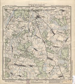
- VAC9619-003826
- Genre:
- Topographic Maps and Military Maps
- Geographic Location:
- Coordinates: 54, 22.875, 54.083, 23
- Related URL:
- Download GeoTIFF: https://drive.google.com/file/d/14r-fQyH7mOY4p-2FsBrew0kTqdalqLS9/view?usp=sharing and Catalog URL: https://iucat.iu.edu/catalog/14701157
- Abstract:
- Modern area represented: Dubowo Pierwsze, Poland
- Call Number:
- G7063.K2 s25 .S6 sheet N-34-70-D-d
- City:
- Дубово 1-ое (Dubowo Pierwsze)
- Copyright Holder:
- No Copyright - United States
- Country:
- Область государственных интересов Германии (Region of German state interest)
- Physical Description:
- Scale: 1:25,000
- Persistent URL:
- http://purl.dlib.indiana.edu/iudl/images/VAC9619/VAC9619-003826
- Provenance:
- Army Map Service Library, OMAHA, Library of Congress Geography & Map Division
-
- Subject:
- Geographic Subject: Bakaniuk, Topical Subject: Maps, and Topical Subject: Soviet Union
- Publisher:
- Генеральный штаб Красной Армии
- Language:
- Russian
- Date Created:
- 1941
- Identifier:
- VAC9619-003825
- Genre:
- Military Maps and Topographic Maps
- Geographic Location:
- Coordinates: 54, 22.75, 54.083, 22.875
- Related URL:
- Download GeoTIFF: https://drive.google.com/file/d/1xrp9zpQVNPo6Yk3_6uuukgaLUlWAn_hf/view?usp=sharing and Catalog URL: https://iucat.iu.edu/catalog/14701157
- Abstract:
- Modern area represented: Bakaniuk, Poland
- Call Number:
- G7063.K2 s25 .S6 sheet N-34-70-D-b
- City:
- Баканюк (Bakaniuk)
- Copyright Holder:
- No Copyright - United States
- Country:
- Область государственных интересов Германии (Region of German state interest)
- Physical Description:
- Scale: 1:25,000
- Persistent URL:
- http://purl.dlib.indiana.edu/iudl/images/VAC9619/VAC9619-003825
- Provenance:
- Army Map Service Library, Library of Congress Geography & Map Division
-
- Subject:
- Topical Subject: Maps, Geographic Subject: Suwałki, and Topical Subject: Soviet Union
- Publisher:
- Генеральный штаб Красной Армии
- Language:
- Russian
- Date Created:
- 1941
- Identifier:
- VAC9619-003824
- Genre:
- Topographic Maps and Military Maps
- Geographic Location:
- Coordinates: 54.083, 22.875, 54.167, 23
- Related URL:
- Download GeoTIFF: https://drive.google.com/file/d/19dVJ3F5H_AziY1NXhM1Qg4ANEdqxp6P6/view?usp=sharing and Catalog URL: https://iucat.iu.edu/catalog/14701157
- Abstract:
- Modern area represented: Suwałki, Poland
- Call Number:
- G7063.K2 s25 .S6 sheet N-34-70-D-b
- City:
- Сувалки (Suwałki)
- Copyright Holder:
- No Copyright - United States
- Country:
- Область государственных интересов Германии (Region of German state interest)
- Physical Description:
- Scale: 1:25,000
- Persistent URL:
- http://purl.dlib.indiana.edu/iudl/images/VAC9619/VAC9619-003824
- Provenance:
- Army Map Service Library, Library of Congress Geography & Map Division
-
- Subject:
- Geographic Subject: Jeleniewo, Topical Subject: Soviet Union, and Topical Subject: Maps
- Publisher:
- Генеральный штаб Красной Армии
- Language:
- Russian
- Date Created:
- 1941
- Identifier:
- VAC9619-003823
- Genre:
- Topographic Maps and Military Maps
- Geographic Location:
- Coordinates: 54.167, 22.875, 54.25, 23
- Related URL:
- Catalog URL: https://iucat.iu.edu/catalog/14701157 and Download GeoTIFF: https://drive.google.com/file/d/1IEXOWeBs29cvuQxpP53jjDmEVm_UF20C/view?usp=sharing
- Abstract:
- Modern area represented: Jeleniewo, Poland
- Call Number:
- G7063.K2 s25 .S6 sheet N-34-70-B-d
- City:
- Еленево (Jeleniewo)
- Copyright Holder:
- No Copyright - United States
- Country:
- Область государственных интересов Германии (Region of German state interest)
- Physical Description:
- Scale: 1:25,000
- Persistent URL:
- http://purl.dlib.indiana.edu/iudl/images/VAC9619/VAC9619-003823
- Provenance:
- Army Map Service Library, OMAHA, Library of Congress Geography & Map Division
-
- Subject:
- Topical Subject: Maps, Topical Subject: Soviet Union, and Geographic Subject: Pawłówka
- Publisher:
- Генеральный штаб Красной Армии
- Language:
- Russian
- Date Created:
- 1941
- Identifier:
- VAC9619-003822
- Genre:
- Military Maps and Topographic Maps
- Geographic Location:
- Coordinates: 54.167, 22.75, 54.25, 22.875
- Related URL:
- Catalog URL: https://iucat.iu.edu/catalog/14701157 and Download GeoTIFF: https://drive.google.com/file/d/1WRVcmyICQCx4nadbxhYZPXA6F1g-zvXj/view?usp=sharing
- Abstract:
- Modern area represented: Nowa Pawłówka and Stara Pawłówka, Poland
- Call Number:
- G7063.K2 s25 .S6 sheet N-34-70-B-c
- City:
- Павлувка (Pawłówka)
- Copyright Holder:
- No Copyright - United States
- Country:
- Область государственных интересов Германии (Region of German state interest)
- Physical Description:
- Scale: 1:25,000
- Persistent URL:
- http://purl.dlib.indiana.edu/iudl/images/VAC9619/VAC9619-003822
- Provenance:
- Army Map Service Library, OMAHA, Library of Congress Geography & Map Division
-
- Subject:
- Topical Subject: Maps, Topical Subject: Soviet Union, and Geographic Subject: Jałowo
- Publisher:
- Генеральный штаб Красной Армии
- Language:
- Russian
- Date Created:
- 1941
- Identifier:
- VAC9619-003821
- Genre:
- Military Maps and Topographic Maps
- Geographic Location:
- Coordinates: 54.25, 22.875, 54.333, 23
- Related URL:
- Download GeoTIFF: https://drive.google.com/file/d/1GBaO0vMThg3_tdSZzuUftYilS4-ltNo6/view?usp=sharing and Catalog URL: https://iucat.iu.edu/catalog/14701157
- Abstract:
- Modern area represented: Jałowo, Poland
- Call Number:
- G7063.K2 s25 .S6 sheet N-34-70-B-b
- City:
- Ялово (Jałowo)
- Copyright Holder:
- No Copyright - United States
- Country:
- Область государственных интересов Германии (Region of German state interest)
- Physical Description:
- Scale: 1:25,000
- Persistent URL:
- http://purl.dlib.indiana.edu/iudl/images/VAC9619/VAC9619-003821
- Provenance:
- DMA Topographic Center, Army Map Service Library, Library of Congress Geography & Map Division
-
- Subject:
- Geographic Subject: Hańcza, Topical Subject: Soviet Union, and Topical Subject: Maps
- Publisher:
- Генеральный штаб Красной Армии
- Language:
- Russian
- Date Created:
- 1941
- Identifier:
- VAC9619-003820
- Genre:
- Military Maps and Topographic Maps
- Geographic Location:
- Coordinates: 54.25, 22.75, 54.333, 22.875
- Related URL:
- Download GeoTIFF: https://drive.google.com/file/d/1th8Iaf_12VIyaDIU0NaPb09nIh7q0PuH/view?usp=sharing and Catalog URL: https://iucat.iu.edu/catalog/14701157
- Abstract:
- Modern area represented: Hańcza, Poland
- Call Number:
- G7063.K2 s25 .S6 sheet N-34-70-B-а
- City:
- Ганьча (Hańcza)
- Copyright Holder:
- No Copyright - United States
- Country:
- Область государственных интересов Германии (Region of German state interest) and Германия (Восточная Пруссия) (Germany (East Prussia))
- Physical Description:
- Scale: 1:25,000
- Persistent URL:
- http://purl.dlib.indiana.edu/iudl/images/VAC9619/VAC9619-003820
- Provenance:
- Army Map Service Library, OMAHA, Library of Congress Geography & Map Division
-
- Subject:
- Geographic Subject: Filipów, Topical Subject: Maps, and Topical Subject: Soviet Union
- Publisher:
- Генеральный штаб Красной Армии
- Language:
- Russian
- Date Created:
- 1941
- Identifier:
- VAC9619-003819
- Genre:
- Military Maps and Topographic Maps
- Geographic Location:
- Coordinates: 54.167, 22.5, 54.25, 22.625
- Related URL:
- Catalog URL: https://iucat.iu.edu/catalog/14701157 and Download GeoTIFF: https://drive.google.com/file/d/1ILUQo4m31FibY21pBMZLAlj5SkpI7Y4W/view?usp=sharing
- Abstract:
- Modern area represented: Filipów, Poland
- Call Number:
- G7063.K2 s25 .S6 sheet N-34-70-A-c
- City:
- Филипув (Filipów)
- Copyright Holder:
- No Copyright - United States
- Country:
- Германия (Восточная Пруссия) (Germany (East Prussia)) and Область государственных интересов Германии (Region of German state interest)
- Physical Description:
- Scale: 1:25,000
- Persistent URL:
- http://purl.dlib.indiana.edu/iudl/images/VAC9619/VAC9619-003819
- Provenance:
- Army Map Service Library, Library of Congress Geography & Map Division
-
- Subject:
- Topical Subject: Maps, Geographic Subject: Dubeninki, and Topical Subject: Soviet Union
- Publisher:
- Генеральный штаб Красной Армии
- Language:
- Russian
- Date Created:
- 1941
- Identifier:
- VAC9619-003818
- Genre:
- Topographic Maps and Military Maps
- Geographic Location:
- Coordinates: 54.25, 22.5, 54.333, 22.625
- Related URL:
- Catalog URL: https://iucat.iu.edu/catalog/14701157 and Download GeoTIFF: https://drive.google.com/file/d/19AcnhuhWm1XPNSHbDJOLdHiW_ecq-eVm/view?usp=sharing
- Abstract:
- Modern area represented: Dubeninki, Poland
- Call Number:
- G7063.K2 s25 .S6 sheet N-34-70-A-а
- City:
- Дубенингкен (Dubeningken)
- Copyright Holder:
- No Copyright - United States
- Country:
- Область государственных интересов Германии (Region of German state interest) and Германия (Восточная Пруссия) (Germany (East Prussia))
- Physical Description:
- Scale: 1:25,000
- Persistent URL:
- http://purl.dlib.indiana.edu/iudl/images/VAC9619/VAC9619-003818
- Provenance:
- Army Map Service Library, OMAHA, Library of Congress Geography & Map Division
-

- Subject:
- Topical Subject: Soviet Union, Geographic Subject: Leszkowice, and Topical Subject: Maps
- Publisher:
- Генеральный штаб Красной Армии
- Language:
- Russian
- Date Created:
- 1941
- Identifier:
- VAC9619-002639
- Genre:
- Topographic Maps and Military Maps
- Geographic Location:
- Coordinates: 51.5, 22.5, 51.667, 22.75
- Related URL:
- Download GeoTIFF: https://drive.google.com/file/d/1zxluSGJ01FtlvAWFM_egGfRn0kedbyCP/view?usp=sharing and Catalog URL: http://iucat.iu.edu/catalog/5020131
- Abstract:
- Modern area represented: Лешковице (Leszkowice), Poland
- Call Number:
- GM G7000 s50 .S68 sheet M-34-22-A
- City:
- Лешковице (Leszkowice)
- Copyright Holder:
- No Copyright - United States
- Country:
- Область государственных интересов Германии (Region of German state interest)
- Physical Description:
- Scale: 1:50,000
- Persistent URL:
- http://purl.dlib.indiana.edu/iudl/images/VAC9619/VAC9619-002639
- Provenance:
- DMA Topographic Center, Army Map Service Library, OMAHA, Library of Congress Geography & Map Division
-
- Subject:
- Topical Subject: Maps, Topical Subject: Soviet Union, and Geographic Subject: Leszkowice
- Publisher:
- Генеральный штаб РККА
- Language:
- Russian
- Date Created:
- 1941
- Identifier:
- VAC9619-002638
- Genre:
- Topographic Maps and Military Maps
- Geographic Location:
- Coordinates: 51.5, 22.5, 51.667, 22.75
- Related URL:
- Catalog URL: http://iucat.iu.edu/catalog/5020131 and Download GeoTIFF: https://drive.google.com/file/d/1-ru48E4UYDJBvNku10aWjihr3PA6Tj6i/view?usp=sharing
- Abstract:
- Modern area represented: Leszkowice, Poland
- Call Number:
- GM G7000 s50 .S68 sheet M-34-22-A
- City:
- Лешковице (Leszkowice)
- Copyright Holder:
- No Copyright - United States
- Country:
- Область государственных интересов Германии (Region of German state interest)
- Physical Description:
- Scale: 1:50,000
- Persistent URL:
- http://purl.dlib.indiana.edu/iudl/images/VAC9619/VAC9619-002638
-
- Subject:
- Topical Subject: Maps, Topical Subject: Soviet Union, and Geographic Subject: Holeszów
- Publisher:
- Генеральный штаб Красной Армии
- Language:
- Russian
- Date Created:
- 1941
- Identifier:
- VAC9619-002637
- Genre:
- Topographic Maps and Military Maps
- Geographic Location:
- Coordinates: 51.667, 23.25, 51.833, 23.5
- Related URL:
- Download GeoTIFF: https://drive.google.com/file/d/1i3ZkibMdOa8Ml_mse338jgWFNAv3twmg/view?usp=sharing and Catalog URL: http://iucat.iu.edu/catalog/5020131
- Abstract:
- Modern area represented: Голешув (Holeszów), Poland
- Call Number:
- GM G7000 s50 .S68 sheet M-34-11-D
- City:
- Голешув (Holeszów)
- Copyright Holder:
- No Copyright - United States
- Country:
- Область государственных интересов Германии (Region of German state interest)
- Physical Description:
- Scale: 1:50,000
- Persistent URL:
- http://purl.dlib.indiana.edu/iudl/images/VAC9619/VAC9619-002637
- Provenance:
- DMA Topographic Center, Army Map Service Library, OMAHA, Library of Congress Geography & Map Division
-
- Subject:
- Geographic Subject: Holeszów, Topical Subject: Soviet Union, and Topical Subject: Maps
- Publisher:
- Генеральный штаб Красной Армии
- Language:
- Russian
- Date Created:
- 1941
- Identifier:
- VAC9619-002636
- Genre:
- Topographic Maps and Military Maps
- Geographic Location:
- Coordinates: 51.667, 23.25, 51.833, 23.5
- Related URL:
- Download GeoTIFF: https://drive.google.com/file/d/1oBBHT5MIHBy5239bvVZ6vbL9acZawCga/view?usp=sharing and Catalog URL: http://iucat.iu.edu/catalog/5020131
- Abstract:
- Modern area represented: Holeszów, Poland
- Call Number:
- GM G7000 s50 .S68 sheet M-34-11-D
- City:
- Голешув (Holeszów)
- Copyright Holder:
- No Copyright - United States
- Country:
- Область государственных интересов Германии (Region of German state interest)
- Physical Description:
- Scale: 1:50,000
- Persistent URL:
- http://purl.dlib.indiana.edu/iudl/images/VAC9619/VAC9619-002636
-
- Subject:
- Geographic Subject: Piszczac, Topical Subject: Maps, and Topical Subject: Soviet Union
- Publisher:
- Генеральный штаб Красной Армии
- Language:
- Russian
- Date Created:
- 1941
- Identifier:
- VAC9619-002635
- Genre:
- Topographic Maps and Military Maps
- Geographic Location:
- Coordinates: 51.833, 23.25, 52, 23.5
- Related URL:
- Download GeoTIFF: https://drive.google.com/file/d/142t5RKNxXqKne56w93rpyltp66DAMAU4/view?usp=sharing and Catalog URL: http://iucat.iu.edu/catalog/5020131
- Abstract:
- Modern area represented: Piszczac, Poland
- Call Number:
- GM G7000 s50 .S68 sheet M-34-11-B
- City:
- Пищац (Piszczac)
- Copyright Holder:
- No Copyright - United States
- Country:
- Область государственных интересов Германии (Region of German state interest)
- Physical Description:
- Scale: 1:50,000
- Persistent URL:
- http://purl.dlib.indiana.edu/iudl/images/VAC9619/VAC9619-002635
-
- Subject:
- Geographic Subject: Łomazy, Topical Subject: Soviet Union, and Topical Subject: Maps
- Publisher:
- Генеральный штаб РККА
- Language:
- Russian
- Date Created:
- 1941
- Identifier:
- VAC9619-002634
- Genre:
- Topographic Maps and Military Maps
- Geographic Location:
- Coordinates: 51.833, 23, 52, 23.25
- Related URL:
- Catalog URL: http://iucat.iu.edu/catalog/5020131 and Download GeoTIFF: https://drive.google.com/file/d/1RbkoScJXhEaptPl4JEHZVYCnCX9rDzQX/view?usp=sharing
- Abstract:
- Modern area represented: Ломазы (Łomazy), Poland
- Call Number:
- GM G7000 s50 .S68 sheet M-34-11-A
- City:
- Ломазы (Łomazy)
- Copyright Holder:
- No Copyright - United States
- Country:
- Область государственных интересов Германии (Region of German state interest)
- Physical Description:
- Scale: 1:50,000
- Persistent URL:
- http://purl.dlib.indiana.edu/iudl/images/VAC9619/VAC9619-002634
- Provenance:
- DMA Topographic Center, Army Map Service Library, OMAHA, Library of Congress Geography & Map Division
-

- Subject:
- Geographic Subject: Międzyrzec, Topical Subject: Soviet Union, and Topical Subject: Maps
- Publisher:
- Генеральный штаб Красной Армии
- Language:
- Russian
- Date Created:
- 1941
- Identifier:
- VAC9619-002631
- Genre:
- Military Maps and Topographic Maps
- Geographic Location:
- Coordinates: 51.833, 22.75, 52, 23
- Related URL:
- Catalog URL: http://iucat.iu.edu/catalog/5020131 and Download GeoTIFF: https://drive.google.com/file/d/1yhicLdyW1G1TdFyU-rylfj9cH98TGr91/view?usp=sharing
- Abstract:
- Modern area represented: Międzyrzec, Poland.
- Call Number:
- GM G7000 S50 .S68 sheet M-34-10-B
- City:
- Мендзыжец (Międzyrzec)
- Copyright Holder:
- No Copyright - United States
- Country:
- Область государственных интересов Германии (Region of German state interest)
- Physical Description:
- Scale: 1:50,000
- Persistent URL:
- http://purl.dlib.indiana.edu/iudl/images/VAC9619/VAC9619-002631
- Provenance:
- DMA Topographic Center, Army Map Service Library, OMAHA, Library of Congress G & M Division
-
- Subject:
- Geographic Subject: Wohyń, Topical Subject: Soviet Union, and Topical Subject: Maps
- Publisher:
- Генеральный штаб Красной Армии
- Language:
- Russian
- Date Created:
- 1941
- Identifier:
- VAC9619-002633
- Genre:
- Military Maps and Topographic Maps
- Geographic Location:
- Coordinates: 51.667, 22.75, 51.833, 23
- Related URL:
- Catalog URL: http://iucat.iu.edu/catalog/5020131 and Download GeoTIFF: https://drive.google.com/file/d/10tZQdaKok1oVwDpVD8i2ILhIrd7EE95n/view?usp=sharing
- Abstract:
- Modern area represented: Wohyń, Poland
- Call Number:
- GM G7000 s50 .S68 sheet M-34-10-D
- City:
- Вогынь (Wohyń)
- Copyright Holder:
- No Copyright - United States
- Country:
- Область государственных интересов Германии (Region of German state interest)
- Physical Description:
- Scale: 1:50,000
- Persistent URL:
- http://purl.dlib.indiana.edu/iudl/images/VAC9619/VAC9619-002633
- Provenance:
- DMA Topographic Center, Army Map Service Library, OMAHA, Library of Congress Geography & Map Division
-
- Subject:
- Geographic Subject: Kąkolewnica, Topical Subject: Maps, and Topical Subject: Soviet Union
- Publisher:
- Генеральный штаб Красной Армии
- Language:
- Russian
- Date Created:
- 1941
- Identifier:
- VAC9619-002630
- Genre:
- Topographic Maps and Military Maps
- Geographic Location:
- Coordinates: 51.833, 22.5, 52, 22.75
- Related URL:
- Download GeoTIFF: https://drive.google.com/file/d/1FILIrkmOHQz2itcJ6kjwwkWN0bocu87_/view?usp=sharing and Catalog URL: http://iucat.iu.edu/catalog/5020131
- Abstract:
- Modern area represented: Kąkolewnica, Poland
- Call Number:
- GM G7000 s50 .S68 sheet M-34-10-A
- City:
- Конколевница (Kąkolewnica)
- Copyright Holder:
- No Copyright - United States
- Country:
- Область государственных интересов Германии (Region of German state interest)
- Physical Description:
- Scale: 1:50,000
- Persistent URL:
- http://purl.dlib.indiana.edu/iudl/images/VAC9619/VAC9619-002630
- Provenance:
- DMA Topographic Center, Army Map Service Library, OMAHA, Library of Congress Geography & Map Division
-
- Subject:
- Topical Subject: Maps, Geographic Subject: Radzyń Podlaski, and Topical Subject: Soviet Union
- Publisher:
- Генеральный штаб Красной Армии
- Language:
- Russian
- Date Created:
- 1941
- Identifier:
- VAC9619-002632
- Genre:
- Topographic Maps and Military Maps
- Geographic Location:
- Coordinates: 51.667, 22.5, 51.833, 22.75
- Related URL:
- Catalog URL: http://iucat.iu.edu/catalog/5020131 and Download GeoTIFF: https://drive.google.com/file/d/1eKvChcGxPitIgwFsgpgt3HkJhi__H6S_/view?usp=sharing
- Abstract:
- Modern area represented: Радзынь-Подляский (Radzyń Podlaski), Poland
- Call Number:
- GM G7000 s50 .S68 sheet M-34-10-C
- City:
- Радзынь Подляски (Radzyń Podlaski)
- Copyright Holder:
- No Copyright - United States
- Country:
- Область государственных интересов Германии (Region of German state interest)
- Physical Description:
- Scale: 1:50,000
- Persistent URL:
- http://purl.dlib.indiana.edu/iudl/images/VAC9619/VAC9619-002632
- Provenance:
- DMA Topographic Center, Army Map Service Library, OMAHA, Library of Congress Geography & Map Division
-

- Subject:
- Geographic Subject: Biała Podlaska, Topical Subject: Soviet Union, and Topical Subject: Maps
- Publisher:
- Генеральный штаб Красной Армии
- Language:
- Russian
- Date Created:
- 1941
- Identifier:
- VAC9619-000386
- Genre:
- Topographic Maps and Military Maps
- Geographic Location:
- Coordinates: 52, 23, 52.1667, 23.25
- Related URL:
- Catalog URL: http://iucat.iu.edu/catalog/5020131 and Download GeoTIFF: https://drive.google.com/open?id=1j9Jb2zoApXKgz_weAAHXPhklR1FYCcmb
- Abstract:
- Modern area represented: Biała Podlaska, Poland
- Call Number:
- G7000 s50 .S68 sheet N-34-143-C
- City:
- Бяла Подляска (Biała Podlaska)
- Copyright Holder:
- No Copyright - United States
- Country:
- Область государственных интересов Германии (Region of German state interest)
- Physical Description:
- Scale: 1:50,000
- Persistent URL:
- http://purl.dlib.indiana.edu/iudl/images/VAC9619/VAC9619-000386
- Provenance:
- Army Map Service Library, OMAHA, Library of Congress Geography & Map Division
-
- Subject:
- Topical Subject: Maps, Geographic Subject: Krzesk-Królowa Niwa, and Topical Subject: Soviet Union
- Publisher:
- Генеральный штаб Красной Армии
- Language:
- Russian
- Date Created:
- 1941
- Identifier:
- VAC9619-000384
- Genre:
- Military Maps and Topographic Maps
- Geographic Location:
- Coordinates: 52, 22.5, 52.1667, 22.75
- Related URL:
- Download GeoTIFF: https://drive.google.com/open?id=1KYJIh1i1xu4izSRnuaaX2KkyP1Uky8SL and Catalog URL: http://iucat.iu.edu/catalog/5020131
- Abstract:
- Modern area represented: Krzesk-Królowa Niwa, Poland
- Call Number:
- G7000 s50 .S68 sheet N-34-142-C
- City:
- Кшеск-Крулева Нива (Krzesk-Królowa Niwa)
- Copyright Holder:
- No Copyright - United States
- Country:
- Область государственных интересов Германии (Region of German state interest)
- Physical Description:
- Scale: 1:50,000
- Persistent URL:
- http://purl.dlib.indiana.edu/iudl/images/VAC9619/VAC9619-000384
- Provenance:
- M. I. Map Library, G000-30
-
- Subject:
- Topical Subject: Soviet Union, Topical Subject: Maps, and Geographic Subject: Swory
- Publisher:
- Генеральный штаб Красной Армии
- Language:
- Russian
- Date Created:
- 1941
- Identifier:
- VAC9619-000385
- Genre:
- Military Maps and Topographic Maps
- Geographic Location:
- Coordinates: 52, 22.75, 52.1667, 23
- Related URL:
- Catalog URL: http://iucat.iu.edu/catalog/5020131 and Download GeoTIFF: https://drive.google.com/open?id=1iNjieZDdXL0iSAoQGAtrxugHpn_AdCxr
- Abstract:
- Modern area represented: Swory, Poland
- Call Number:
- G7000 s50 .S68 sheet N-34-142-D
- Caption:
- Captured map
- City:
- Своры (Swory)
- Copyright Holder:
- No Copyright - United States
- Country:
- Область государственных интересов Германии (Region of German state interest)
- Physical Description:
- Scale: 1:50,000
- Persistent URL:
- http://purl.dlib.indiana.edu/iudl/images/VAC9619/VAC9619-000385
- Provenance:
- DMA Topographic Center, Army Map Service Library, OMAHA, Library of Congress Geography & Map Division
-
- Subject:
- Topical Subject: Maps, Topical Subject: Soviet Union, and Geographic Subject: Mokobody
- Publisher:
- Генеральный штаб Красной Армии
- Language:
- Russian
- Date Created:
- 1941
- Identifier:
- VAC9619-000381
- Genre:
- Topographic Maps and Military Maps
- Geographic Location:
- Coordinates: 52.1667, 22, 52.3333, 22.25
- Related URL:
- Catalog URL: http://iucat.iu.edu/catalog/5020131 and Download GeoTIFF: https://drive.google.com/open?id=1ouJ804ACOTOR3T2kEqiiASXr2R4REZAh
- Abstract:
- Modern area represented: Mokobody, Poland
- Call Number:
- G7000 s50 .S68 sheet N-34-141-A
- Caption:
- Captured map
- City:
- Мокободы (Mokobody)
- Copyright Holder:
- No Copyright - United States
- Country:
- Область государственных интересов Германии (Region of German state interest)
- Physical Description:
- Scale: 1:50,000
- Persistent URL:
- http://purl.dlib.indiana.edu/iudl/images/VAC9619/VAC9619-000381
- Provenance:
- Army Map Service Library, OMAHA, Library of Congress Geography & Map Division
-
- Subject:
- Geographic Subject: Pruszyn, Topical Subject: Maps, and Topical Subject: Soviet Union
- Publisher:
- Генеральный штаб Красной Армии
- Language:
- Russian
- Date Created:
- 1941
- Identifier:
- VAC9619-000382
- Genre:
- Military Maps and Topographic Maps
- Geographic Location:
- Coordinates: 52.1667, 22.25, 52.3333, 22.5
- Related URL:
- Download GeoTIFF: https://drive.google.com/open?id=15b5hrAJ9da_wcemnEC0AhFb8-lwLrq4y and Catalog URL: http://iucat.iu.edu/catalog/5020131
- Abstract:
- Modern area represented: Pruszyn, Poland
- Call Number:
- G7000 s50 .S68 sheet N-34-141-B
- Caption:
- Captured map
- City:
- Прушин (Pruszyn)
- Copyright Holder:
- No Copyright - United States
- Country:
- Область государственных интересов Германии (Region of German state interest)
- Physical Description:
- Scale: 1:50,000
- Persistent URL:
- http://purl.dlib.indiana.edu/iudl/images/VAC9619/VAC9619-000382
- Provenance:
- Army Map Service Library, OMAHA, Library of Congress Geography & Map Division
-
- Subject:
- Topical Subject: Maps, Topical Subject: Soviet Union, and Geographic Subject: Gołymin-Ośrodek
- Publisher:
- Генеральный штаб Красной Армии
- Language:
- Russian
- Date Created:
- 1941
- Identifier:
- VAC9619-000380
- Genre:
- Topographic Maps and Military Maps
- Geographic Location:
- Coordinates: 52.6667, 20.75, 52.8333, 21
- Related URL:
- Download GeoTIFF: https://drive.google.com/open?id=1TK2aF8RMGAbdEVm4XuSX3vzj2tJntdbW and Catalog URL: http://iucat.iu.edu/catalog/5020131
- Abstract:
- Modern area represented: Gołymin-Ośrodek, Poland
- Call Number:
- G7000 s50 .S68 sheet N-114-D
- Caption:
- Captured map
- City:
- Голымин Стары
- Copyright Holder:
- No Copyright - United States
- Country:
- Область государственных интересов Германии (Region of German state interest)
- Physical Description:
- Scale: 1:50,000
- Persistent URL:
- http://purl.dlib.indiana.edu/iudl/images/VAC9619/VAC9619-000380
- Provenance:
- Army Map Service Library, OMAHA, Library of Congress Geography & Map Division
-
- Subject:
- Topical Subject: Maps, Geographic Subject: Ciechanów, and Topical Subject: Soviet Union
- Publisher:
- Генеральный штаб Красной Армии
- Language:
- Russian
- Date Created:
- 1941
- Identifier:
- VAC9619-000378
- Genre:
- Military Maps and Topographic Maps
- Geographic Location:
- Coordinates: 52.8333, 20.5, 53, 20.75
- Related URL:
- Download GeoTIFF: https://drive.google.com/open?id=19NZpMB0LLhTETWhRYs6IvVgTW8lNhNOq and Catalog URL: http://iucat.iu.edu/catalog/5020131
- Abstract:
- Modern area represented: Ciechanów, Poland
- Call Number:
- G7000 s50 .S68 sheet N-34-114-A
- Caption:
- Captured map
- City:
- Цеханув
- Copyright Holder:
- No Copyright - United States
- Country:
- Область государственных интересов Германии (Region of German state interest)
- Physical Description:
- Scale: 1:50,000
- Persistent URL:
- http://purl.dlib.indiana.edu/iudl/images/VAC9619/VAC9619-000378
- Provenance:
- Army Map Service Library, OMAHA, Library of Congress Geography & Map Division
-
- Subject:
- Topical Subject: Soviet Union, Geographic Subject: Bogate, and Topical Subject: Maps
- Publisher:
- Генеральный штаб Красной Армии
- Language:
- Russian
- Date Created:
- 1941
- Identifier:
- VAC9619-000379
- Genre:
- Topographic Maps and Military Maps
- Geographic Location:
- Coordinates: 52.8333, 20.75, 53, 21
- Related URL:
- Download GeoTIFF: https://drive.google.com/open?id=1OYtTAtvkxii-vu8ffUIJ7Tr13jXX4SK3 and Catalog URL: http://iucat.iu.edu/catalog/5020131
- Abstract:
- Modern area represented: Bogate, Poland
- Call Number:
- G7000 s50 .S68 sheet N-34-114-B
- Caption:
- Captured map
- City:
- Богате (Bogate)
- Copyright Holder:
- No Copyright - United States
- Country:
- Область государственных интересов Германии (Region of German state interest)
- Physical Description:
- Scale: 1:50,000
- Persistent URL:
- http://purl.dlib.indiana.edu/iudl/images/VAC9619/VAC9619-000379
- Provenance:
- Army Map Service Library, OMAHA, Library of Congress Geography & Map Division
-
- Description:
- 1884
- Subject:
- Geographic Subject: Długosiodło, Topical Subject: Maps, and Topical Subject: Soviet Union
- Publisher:
- Генеральный штаб Красной Армии
- Language:
- Russian
- Date Created:
- 1941
- Identifier:
- VAC9619-000376
- Genre:
- Military Maps and Topographic Maps
- Geographic Location:
- Coordinates: 52.6667, 21.5, 52.8333, 21.75
- Related URL:
- Download GeoTIFF: https://drive.google.com/open?id=1T-Qz5bOSE5q8tCH-IRzdNgn-8aiO4xmF and Catalog URL: http://iucat.iu.edu/catalog/5020131
- Abstract:
- Modern area represented: Długosiodło, Poland
- Call Number:
- G7000 s50 .S68 sheet N-34-116-C
- Caption:
- Captured map
- City:
- Длугоседло (Długosiodło)
- Copyright Holder:
- No Copyright - United States
- Country:
- Область государственных интересов Германии (Region of German state interest)
- Physical Description:
- Scale: 1:50,000
- Persistent URL:
- http://purl.dlib.indiana.edu/iudl/images/VAC9619/VAC9619-000376
- Provenance:
- DMA Topographic Center, Army Map Service Library, OMAHA, Library of Congress Geography & Map Division
-
- Subject:
- Topical Subject: Maps, Geographic Subject: Kadzidło, and Topical Subject: Soviet Union
- Publisher:
- Генеральный штаб Красной Армии
- Language:
- Russian
- Date Created:
- 1941
- Identifier:
- VAC9619-000375
- Genre:
- Military Maps and Topographic Maps
- Geographic Location:
- Coordinates: 53.1667, 21.25, 53.3333, 21.5
- Related URL:
- Download GeoTIFF: https://drive.google.com/open?id=1j9TNkrVh9BXQBw6WeFoz2ySmuIR1j57S and Catalog URL: http://iucat.iu.edu/catalog/5020131
- Abstract:
- Modern area represented: Kadzidło, Poland
- Call Number:
- G7000 s50 .S68 sheet N-34-103-B
- Caption:
- Captured map
- City:
- Кадзидло (Kadzidło)
- Copyright Holder:
- No Copyright - United States
- Country:
- Область государственных интересов Германии (Region of German state interest)
- Physical Description:
- Scale: 1:50,000
- Persistent URL:
- http://purl.dlib.indiana.edu/iudl/images/VAC9619/VAC9619-000375
- Provenance:
- DMA Topographic Center, Army Map Service Library, OMAHA, Library of Congress Geography & Map Division
-
- Subject:
- Topical Subject: Soviet Union, Geographic Subject: Rząśnik, and Topical Subject: Maps
- Publisher:
- Генеральный штаб Красной Армии
- Language:
- Russian
- Date Created:
- 1941
- Identifier:
- VAC9619-000374
- Genre:
- Military Maps and Topographic Maps
- Geographic Location:
- Coordinates: 52.6667, 21.25, 52.8333, 21.5
- Related URL:
- Download GeoTIFF: https://drive.google.com/open?id=1uEtiy2E8NxCTOz1ekpLYzL3f02iqwx-k and Catalog URL: http://iucat.iu.edu/catalog/5020131
- Abstract:
- Modern area represented: Rząśnik, Poland
- Call Number:
- G7000 s50 .S68 sheet N-34-115-D
- Caption:
- Captured map
- City:
- Жонсьник (Rząśnik)
- Copyright Holder:
- No Copyright - United States
- Country:
- Область государственных интересов Германии (Region of German state interest)
- Physical Description:
- Scale: 1:50,000
- Persistent URL:
- http://purl.dlib.indiana.edu/iudl/images/VAC9619/VAC9619-000374
- Provenance:
- DMA Topographic Center, Army Map Service Library, OMAHA, Library of Congress Geography & Map Division
-
- Subject:
- Topical Subject: Soviet Union, Geographic Subject: Różan, and Topical Subject: Maps
- Publisher:
- Генеральный штаб Красной Армии
- Language:
- Russian
- Date Created:
- 1941
- Identifier:
- VAC9619-000373
- Genre:
- Military Maps and Topographic Maps
- Geographic Location:
- Coordinates: 52.8333, 21.25, 53, 21.5
- Related URL:
- Catalog URL: http://iucat.iu.edu/catalog/5020131 and Download GeoTIFF: https://drive.google.com/open?id=1JKYAMQraaYyBFcArKBpbqCb1sNSqgNAQ
- Abstract:
- Modern area represented: Różan, Poland
- Call Number:
- G7000 s50 .S68 sheet N-34-115-B
- Caption:
- Captured map
- City:
- Рожан (Różan)
- Copyright Holder:
- No Copyright - United States
- Country:
- Область государственных интересов Германии (Region of German state interest)
- Physical Description:
- Scale: 1:50,000
- Persistent URL:
- http://purl.dlib.indiana.edu/iudl/images/VAC9619/VAC9619-000373
- Provenance:
- Army Map Service Library, OMAHA, Library of Congress Geography & Map Division
-
- Subject:
- Geographic Subject: Przasnysz, Topical Subject: Soviet Union, and Topical Subject: Maps
- Publisher:
- Генеральный штаб Красной Армии
- Language:
- Russian
- Date Created:
- 1941
- Identifier:
- VAC9619-000372
- Genre:
- Military Maps and Topographic Maps
- Geographic Location:
- Coordinates: 53, 20.75, 53.1667, 21
- Related URL:
- Download GeoTIFF: https://drive.google.com/open?id=18kHMYco-Vk6Xg66dtxBUOZaAemYZa__a and Catalog URL: http://iucat.iu.edu/catalog/5020131
- Abstract:
- Modern area represented: Przasnysz, Poland
- Call Number:
- G7000 s50 .S68 sheet N-34-102-D
- Caption:
- Captured map
- City:
- Пшасныш (Przasnysz)
- Copyright Holder:
- No Copyright - United States
- Country:
- Область государственных интересов Германии (Region of German state interest)
- Physical Description:
- Scale: 1:50,000
- Persistent URL:
- http://purl.dlib.indiana.edu/iudl/images/VAC9619/VAC9619-000372
- Provenance:
- DMA Topographic Center, Army Map Service Library, OMAHA, Library of Congress Geography & Map Division
-
- Description:
- 1886
- Subject:
- Geographic Subject: Grudusk, Topical Subject: Maps, and Topical Subject: Soviet Union
- Publisher:
- Генеральный штаб Красной Армии
- Language:
- Russian
- Date Created:
- 1941
- Identifier:
- VAC9619-000371
- Genre:
- Topographic Maps and Military Maps
- Geographic Location:
- Coordinates: 53, 20.5, 53.1667, 20.75
- Related URL:
- Catalog URL: http://iucat.iu.edu/catalog/5020131 and Download GeoTIFF: https://drive.google.com/open?id=121AJ8AAladdTR23R4U1k7xSqvCU6PdBX
- Abstract:
- Modern area represented: Grudusk, Poland
- Call Number:
- G7000 s50 .S68 sheet N-34-102-C
- Caption:
- Captured map
- City:
- Грудуск (Grudusk)
- Copyright Holder:
- No Copyright - United States
- Country:
- Область государственных интересов Германии (Region of German state interest)
- Physical Description:
- Scale: 1:50,000
- Persistent URL:
- http://purl.dlib.indiana.edu/iudl/images/VAC9619/VAC9619-000371
- Provenance:
- DMA Topographic Center, Army Map Service Library, OMAHA, Library of Congress Geography & Map Division
-
- Subject:
- Geographic Subject: Janowo, Topical Subject: Soviet Union, and Topical Subject: Maps
- Publisher:
- Генеральный штаб Красной Армии
- Language:
- Russian
- Date Created:
- 1941
- Identifier:
- VAC9619-000369
- Genre:
- Military Maps and Topographic Maps
- Geographic Location:
- Coordinates: 53.1667, 20.5, 53.3333, 20.75
- Related URL:
- Catalog URL: http://iucat.iu.edu/catalog/5020131 and Download GeoTIFF: https://drive.google.com/open?id=1UYLIVjiuM5rVviviizhQkKcRS6_koE_z
- Abstract:
- Modern area represented: Janowo, Poland
- Call Number:
- G7000 s50 .S68 sheet N-34-102-A
- Caption:
- Captured map
- City:
- Яново (Janowo)
- Copyright Holder:
- No Copyright - United States
- Country:
- Германия (Germany), Восточная Пруссия (East Prussia), and Область государственных интересов Германии (Region of German state interest)
- Physical Description:
- Scale: 1:50,000
- Persistent URL:
- http://purl.dlib.indiana.edu/iudl/images/VAC9619/VAC9619-000369
- Provenance:
- DMA Topographic Center, Army Map Service Library, OMAHA, Library of Congress Geography & Map Division
-
- Subject:
- Topical Subject: Soviet Union, Geographic Subject: Chorzele, and Topical Subject: Maps
- Publisher:
- Генеральный штаб Красной Армии
- Language:
- Russian
- Date Created:
- 1941
- Identifier:
- VAC9619-000370
- Genre:
- Military Maps and Topographic Maps
- Geographic Location:
- Coordinates: 53.1667, 20.75, 53.3333, 21
- Related URL:
- Download GeoTIFF: https://drive.google.com/open?id=1eT_SRLdiphOMmD85IKw1gqQJSPCLmqJ_ and Catalog URL: http://iucat.iu.edu/catalog/5020131
- Abstract:
- Modern area represented: Chorzele, Poland
- Call Number:
- G7000 s50 .S68 sheet N-34-102-B
- City:
- Хожеле (Khozhele)
- Copyright Holder:
- No Copyright - United States
- Country:
- Область государственных интересов Германии (Region of German state interest), Германия (Germany), and Восточная Пруссия (East Prussia)
- Physical Description:
- Scale: 1:50,000
- Persistent URL:
- http://purl.dlib.indiana.edu/iudl/images/VAC9619/VAC9619-000370
- Provenance:
- DMA Topographic Center, Army Map Service Library, OMAHA, Library of Congress Geography & Map Division
-
- Subject:
- Topical Subject: Soviet Union, Geographic Subject: Myszyniec, and Topical Subject: Maps
- Publisher:
- Генеральный штаб Красной Армии
- Language:
- Russian
- Date Created:
- 1941
- Identifier:
- VAC9619-000367
- Genre:
- Topographic Maps and Military Maps
- Geographic Location:
- Coordinates: 53.3333, 21.25, 53.5, 21.5
- Related URL:
- Catalog URL: http://iucat.iu.edu/catalog/5020131 and Download GeoTIFF: https://drive.google.com/open?id=1FYXXnu6YQ3Mr7ySKdf7m7E2v6f7ARySH
- Abstract:
- Modern area represented: Myszyniec, Poland
- Call Number:
- G7000 s50 .S68 sheet N-34-91-D
- Caption:
- Captured map
- City:
- Мышинец (Myszyniec)
- Copyright Holder:
- No Copyright - United States
- Country:
- Германия (Germany), Область государственных интересов Германии (Region of German state interest), and Восточная Пруссия (East Prussia)
- Physical Description:
- Scale: 1:50,000
- Persistent URL:
- http://purl.dlib.indiana.edu/iudl/images/VAC9619/VAC9619-000367
- Provenance:
- DMA Topographic Center, Army Map Service Library, Library of Congress Geography & Map Division
-
- Subject:
- Geographic Subject: Maków Mazowiecki, Topical Subject: Maps, and Topical Subject: Soviet Union
- Publisher:
- Генеральный штаб Красной Армии
- Language:
- Russian
- Date Created:
- 1941
- Identifier:
- VAC9619-000363
- Genre:
- Topographic Maps and Military Maps
- Geographic Location:
- Coordinates: 52.8333, 21, 53, 21.25
- Related URL:
- Download GeoTIFF: https://drive.google.com/open?id=1UttvJpJWpIyx_fyNwX6e794CJbRv2oKu and Catalog URL: http://iucat.iu.edu/catalog/5020131
- Abstract:
- Modern area represented: Maków Mazowiecki, Poland
- Call Number:
- G7000 s50 .S68 sheet N-34-115-A
- Caption:
- Captured map
- City:
- Макув (Maków)
- Copyright Holder:
- No Copyright - United States
- Country:
- Область государственных интересов Германии (Region of German state interest)
- Physical Description:
- Scale: 1:50,000
- Persistent URL:
- http://purl.dlib.indiana.edu/iudl/images/VAC9619/VAC9619-000363
- Provenance:
- Army Map Service Library, OMAHA, Library of Congress Geography & Map Division
-
- Subject:
- Geographic Subject: Olecko, Topical Subject: Soviet Union, and Topical Subject: Maps
- Publisher:
- Генеральный штаб Красной Армии
- Language:
- Russian
- Date Created:
- 1941
- Identifier:
- VAC9619-000354
- Genre:
- Topographic Maps and Military Maps
- Geographic Location:
- Coordinates: 54.0, 22.5, 54.166667, 22.75
- Related URL:
- Download GeoTIFF: https://drive.google.com/open?id=1WNDxDhKCEjUwfDRkE1jGhIeQso3c6ZO4 and Catalog URL: http://iucat.iu.edu/catalog/5020131
- Abstract:
- Modern area represented: Olecko, Poland
- Call Number:
- G7000 s50 .S68 sheet N-34-70-C
- City:
- Тройбург (Treuburg)
- Copyright Holder:
- No Copyright - United States
- Country:
- Область государственных интересов Германии (Region of German state interest) and Германия (Germany)
- Physical Description:
- Scale: 1:50,000
- Persistent URL:
- http://purl.dlib.indiana.edu/iudl/images/VAC9619/VAC9619-000354
- Provenance:
- DMA Topographic Center, Army Map Service Library, Library of Congress Geography & Map Division
-

- Subject:
- Geographic Subject: Nasielsk, Topical Subject: Soviet Union, and Topical Subject: Maps
- Publisher:
- Генеральный штаб Красной Армии
- Language:
- Russian
- Date Created:
- 1941
- Identifier:
- VAC9619-000350
- Genre:
- Military Maps and Topographic Maps
- Geographic Location:
- Coordinates: 52.5, 20.75, 52.666667, 21.0
- Related URL:
- Download GeoTIFF: https://drive.google.com/open?id=1j4KIcDQOqpPMkMy-n2Pr6cSGIWrGggEl and Catalog URL: http://iucat.iu.edu/catalog/5020131
- Abstract:
- Modern area represented: Nasielsk, Poland
- Call Number:
- G7000 s50 .S68 sheet N-34-126-B
- Caption:
- Captured map
- City:
- Насельск (Nasielsk)
- Copyright Holder:
- No Copyright - United States
- Country:
- Область государственных интересов Германии (Region of German state interest)
- Physical Description:
- Scale: 1:50,000
- Persistent URL:
- http://purl.dlib.indiana.edu/iudl/images/VAC9619/VAC9619-000350
- Provenance:
- Army Map Service Library, OMAHA, Library of Congress Geography & Map Division
-
- Subject:
- Geographic Subject: Nowe Miasto, Topical Subject: Soviet Union, and Topical Subject: Maps
- Publisher:
- Генеральный штаб Красной Армии
- Language:
- Russian
- Date Created:
- 1941
- Identifier:
- VAC9619-000342
- Genre:
- Topographic Maps and Military Maps
- Geographic Location:
- Coordinates: 52.5, 20.5, 52.6667, 20.75
- Related URL:
- Catalog URL: http://iucat.iu.edu/catalog/5020131 and Download GeoTIFF: https://drive.google.com/open?id=1ouJacKa7i_4QxBSo2r2IGNaMv3GUrRS9
- Abstract:
- Modern area represented: Nowe Miasto, Poland
- Call Number:
- G7000 s50 .S68 sheet N-34-126-A
- Caption:
- Captured map
- City:
- Нове-Място (Nowe Miasto)
- Copyright Holder:
- No Copyright - United States
- Country:
- Область государственных интересов Германии (Region of German state interest)
- Physical Description:
- Scale: 1:50,000
- Persistent URL:
- http://purl.dlib.indiana.edu/iudl/images/VAC9619/VAC9619-000342
- Provenance:
- Army Map Service Library, OMAHA, Library of Congress Geography & Map Division
-
- Subject:
- Geographic Subject: Latowicz, Topical Subject: Soviet Union, and Topical Subject: Maps
- Publisher:
- Генеральный штаб Красной Армии
- Language:
- Russian
- Date Created:
- 1941
- Identifier:
- VAC9619-000340
- Genre:
- Topographic Maps and Military Maps
- Geographic Location:
- Coordinates: 52.0, 21.75, 52.166667, 22.0
- Related URL:
- Download GeoTIFF: https://drive.google.com/open?id=1ifVCloGvj7k8gskS3r87hxY43z_qtROX and Catalog URL: http://iucat.iu.edu/catalog/5020131
- Abstract:
- Modern area represented: Latowicz, Poland
- Call Number:
- G7000 s50 .S68 sheet N-34-140-D
- Caption:
- Captured map
- City:
- Лятович (Latowicz)
- Copyright Holder:
- No Copyright - United States
- Country:
- Область государственных интересов Германии (Region of German state interest)
- Physical Description:
- Scale: 1:50,000
- Persistent URL:
- http://purl.dlib.indiana.edu/iudl/images/VAC9619/VAC9619-000340
- Provenance:
- Army Map Service Library, OMAHA, Library of Congress Geography & Map Division
-
- Subject:
- Geographic Subject: Cegłów, Topical Subject: Soviet Union, and Topical Subject: Maps
- Publisher:
- Генеральный штаб Красной Армии
- Language:
- Russian
- Date Created:
- 1941
- Identifier:
- VAC9619-000336
- Genre:
- Military Maps and Topographic Maps
- Geographic Location:
- Coordinates: 52, 21.5, 52.167, 21.75
- Related URL:
- Download GeoTIFF: https://drive.google.com/open?id=1EwlXwAYp5zAgkg8DJ__OMlHFwctYLxzf and Catalog URL: http://iucat.iu.edu/catalog/5020131
- Abstract:
- Modern area represented: Cegłów, Poland
- Call Number:
- G7000 s50 .S68 sheet N-34-140-C
- Caption:
- Captured map
- City:
- Цеглув (Cegłów)
- Copyright Holder:
- No Copyright - United States
- Country:
- Область государственных интересов Германии (Region of German state interest)
- Physical Description:
- Scale: 1:50,000
- Persistent URL:
- http://purl.dlib.indiana.edu/iudl/images/VAC9619/VAC9619-000336
- Provenance:
- Army Map Service Library, OMAHA, Library of Congress Geography & Map Division
-

- Subject:
- Topical Subject: Soviet Union, Topical Subject: Maps, and Geographic Subject: Kałuszyn
- Publisher:
- Генеральный штаб Красной Армии
- Language:
- Russian
- Date Created:
- 1941
- Identifier:
- VAC9619-000335
- Genre:
- Military Maps and Topographic Maps
- Geographic Location:
- Coordinates: 52.166667, 21.75, 52.333333, 22.0
- Related URL:
- Download GeoTIFF: https://drive.google.com/open?id=1Sb-EziIgk9d7S9DVnzeYYee0wU_oK9Q9 and Catalog URL: http://iucat.iu.edu/catalog/5020131
- Abstract:
- Modern area represented: Kałuszyn, Poland
- Call Number:
- G7000 s50 .S68 sheet N-34-140-B
- Caption:
- Captured map
- City:
- Калушин (Kałuszyn)
- Copyright Holder:
- No Copyright - United States
- Country:
- Область государственных интересов Германии (Region of German state interest)
- Physical Description:
- Scale: 1:50,000
- Persistent URL:
- http://purl.dlib.indiana.edu/iudl/images/VAC9619/VAC9619-000335
- Provenance:
- Army Map Service Library, OMAHA, Library of Congress Geography & Map Division
-
- Subject:
- Geographic Subject: Otwock, Topical Subject: Maps, and Topical Subject: Soviet Union
- Publisher:
- Генеральный штаб Красной Армии
- Language:
- Russian
- Date Created:
- 1941
- Identifier:
- VAC9619-000334
- Genre:
- Military Maps and Topographic Maps
- Geographic Location:
- Coordinates: 52.0, 21.25, 52.166667, 21.5
- Related URL:
- Download GeoTIFF: https://drive.google.com/open?id=1tzxGHRI-6ocIi24fLP8Jt-gY1ypldrg9 and Catalog URL: http://iucat.iu.edu/catalog/5020131
- Abstract:
- Modern area represented: Otwock, Poland
- Call Number:
- G7000 s50 .S68 sheet N-34-139-D
- Caption:
- Captured map
- City:
- Отвоцк (Otwock)
- Copyright Holder:
- No Copyright - United States
- Country:
- Область государственных интересов Германии (Region of German state interest)
- Physical Description:
- Scale: 1:50,000
- Persistent URL:
- http://purl.dlib.indiana.edu/iudl/images/VAC9619/VAC9619-000334
- Provenance:
- Army Map Service Library, OMAHA, Library of Congress Geography & Map Division
-
- Subject:
- Topical Subject: Maps, Geographic Subject: Falenica, and Topical Subject: Soviet Union
- Publisher:
- Генеральный штаб Красной Армии
- Language:
- Russian
- Date Created:
- 1941
- Identifier:
- VAC9619-000329
- Genre:
- Military Maps and Topographic Maps
- Geographic Location:
- Coordinates: 52.166667, 20.5, 52.333333, 20.75
- Related URL:
- Download GeoTIFF: https://drive.google.com/open?id=1TiZZtMySQKcWPGuKrnNi2kxqB-ERle2K and Catalog URL: http://iucat.iu.edu/catalog/5020131
- Abstract:
- Modern area represented: Falenica, Warszawa district, Poland
- Call Number:
- G7000 s50 .S68 sheet N-34-139-C
- City:
- Фаленица (Falenica)
- Copyright Holder:
- No Copyright - United States
- Country:
- Область государственных интересов Германии (Region of German state interest)
- Physical Description:
- Scale: 1:50,000
- Persistent URL:
- http://purl.dlib.indiana.edu/iudl/images/VAC9619/VAC9619-000329
- Provenance:
- M. I. Map Library, G000-30, GS, RA, Atlasblatt
-
- Subject:
- Topical Subject: Soviet Union, Geographic Subject: Okuniew, and Topical Subject: Maps
- Publisher:
- Генеральный штаб Красной Армии
- Language:
- Russian
- Date Created:
- 1941
- Identifier:
- VAC9619-000328
- Genre:
- Military Maps and Topographic Maps
- Geographic Location:
- Coordinates: 52.166667, 21.25, 52.333333, 21.5
- Related URL:
- Catalog URL: http://iucat.iu.edu/catalog/5020131 and Download GeoTIFF: https://drive.google.com/open?id=1Eb2daHA4eMeqlCMLjI2TOtyftg5RuEM5
- Abstract:
- Modern area represented: Okuniew, Poland
- Call Number:
- G7000 s50 .S68 sheet N-34-139-B
- Caption:
- Captured map
- City:
- Окунев (Okuniew)
- Copyright Holder:
- No Copyright - United States
- Country:
- Область государственных интересов Германии (Region of German state interest)
- Physical Description:
- Scale: 1:50,000
- Persistent URL:
- http://purl.dlib.indiana.edu/iudl/images/VAC9619/VAC9619-000328
- Provenance:
- Army Map Service Library, OMAHA, Library of Congress Geography & Map Division
-
- Subject:
- Topical Subject: Maps, Geographic Subject: Warszawa, and Topical Subject: Soviet Union
- Publisher:
- Генеральный штаб Красной Армии
- Language:
- Russian
- Date Created:
- 1941
- Identifier:
- VAC9619-000325
- Genre:
- Military Maps and Topographic Maps
- Related URL:
- Catalog URL: http://iucat.iu.edu/catalog/5020131
- Abstract:
- Modern area represented: Warszawa, Poland
- Call Number:
- G7000 s50 .S68 sheet N-34-139-A
- City:
- Варшава (Warszawa)
- Copyright Holder:
- No Copyright - United States
- Country:
- Область государственных интересов Германии (Region of German state interest)
- Physical Description:
- Scale: 1:50,000
- Persistent URL:
- http://purl.dlib.indiana.edu/iudl/images/VAC9619/VAC9619-000325
- Provenance:
- CIA Map Library
-
- Subject:
- Geographic Subject: Pruszków, Topical Subject: Soviet Union, and Topical Subject: Maps
- Publisher:
- Генеральный штаб Красной Армии
- Language:
- Russian
- Date Created:
- 1941
- Identifier:
- VAC9619-000319
- Genre:
- Military Maps and Topographic Maps
- Geographic Location:
- Coordinates: 52.0, 20.75, 52.166667, 21.0
- Related URL:
- Catalog URL: http://iucat.iu.edu/catalog/5020131 and Download GeoTIFF: https://drive.google.com/open?id=1RhrUOPS54pH5r4qpvpPZid2tgwjiqAKe
- Abstract:
- Modern area represented: Pruszków, Poland
- Call Number:
- G7000 s50 .S68 sheet N-34-138-D
- Caption:
- Captured map
- City:
- Прушкув (Pruszków)
- Copyright Holder:
- No Copyright - United States
- Country:
- Область государственных интересов Германии (Region of German state interest)
- Physical Description:
- Scale: 1:50,000
- Persistent URL:
- http://purl.dlib.indiana.edu/iudl/images/VAC9619/VAC9619-000319
- Provenance:
- Army Map Service Library, OMAHA, Library of Congress Geography & Map Division
-
- Subject:
- Geographic Subject: Włochy, Topical Subject: Soviet Union, and Topical Subject: Maps
- Publisher:
- Генеральный штаб Красной Армии
- Language:
- Russian
- Date Created:
- 1941
- Identifier:
- VAC9619-000307
- Genre:
- Military Maps and Topographic Maps
- Geographic Location:
- Coordinates: 52.167, 20.75, 52.333, 21
- Related URL:
- Catalog URL: http://iucat.iu.edu/catalog/5020131 and Download GeoTIFF: https://drive.google.com/open?id=14C8fA7ssMrS5fiNf1B-23TndSJGF1Gt_
- Abstract:
- Modern area represented: Włochy, Warszawa district, Poland
- Call Number:
- G7000 s50 .S68 sheet N-34-138-B
- Caption:
- Captured map
- City:
- Влохы (Włochy)
- Copyright Holder:
- No Copyright - United States
- Country:
- Область государственных интересов Германии (Region of German state interest)
- Physical Description:
- Scale: 1:50,000
- Persistent URL:
- http://purl.dlib.indiana.edu/iudl/images/VAC9619/VAC9619-000307
- Provenance:
- Army Map Service Library, OMAHA, Library of Congress Geography & Map Division
-
- Subject:
- Topical Subject: Maps, Geographic Subject: Węgrów, and Topical Subject: Soviet Union
- Publisher:
- Генеральный штаб Красной Армии
- Language:
- Russian
- Date Created:
- 1941
- Identifier:
- VAC9619-000301
- Genre:
- Topographic Maps and Military Maps
- Geographic Location:
- Coordinates: 52.333, 22, 52.5, 22.25
- Related URL:
- https://drive.google.com/open?id=1AstHWpyMNvTtx5Ctj4KwLBTAmsNWn4dd, Catalog URL: http://iucat.iu.edu/catalog/5020131, and Download GeoTIFF: https://drive.goo...
- Abstract:
- Modern area represented: Węgrów, Poland
- Call Number:
- G7000 s50 .S68 sheet N-34-129-C
- Caption:
- Captured map
- City:
- Венгров (Węgrów)
- Copyright Holder:
- No Copyright - United States
- Country:
- Область государственных интересов Германии (Region of German state interest)
- Physical Description:
- Scale: 1:50,000
- Persistent URL:
- http://purl.dlib.indiana.edu/iudl/images/VAC9619/VAC9619-000301
- Provenance:
- Army Map Service Library, OMAHA, Library of Congress Geography & Map Division
