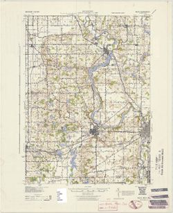
Prepared under the direction of the Chief of Engineers, U. S. Army, 1943. Army Map Service, Quincy unit. At head of map: Michigan 1:62,500. Filing title: Nil...
Call Number:
G4090 s62 .G4 Niles 1943
Caption:
Imprint: Washington, D.C. : Army Map Service, U.S. Army, 1943
Physical Description:
Scale: 1:62,500 and Dimensions: 45 x 42 cm or smaller
Geographic Subject: Berrien County (Mich.) and Geographic Subject: Saint Joseph County (Ind.)
Creator:
Gehres, W. S. (Wilmer Sherman), 1887-1963, Geological Survey (U.S.), Plushnick, A. W. (Andrew Winfield), 1898-1980, U.S. Lake Survey, Michigan. Geological Su...
Publisher:
Geological Survey (U.S.)
Date Created:
1930
Identifier:
VAC3073-M-01363
Genre:
15 minute topographic maps, Quadrangle maps, and Topographic maps
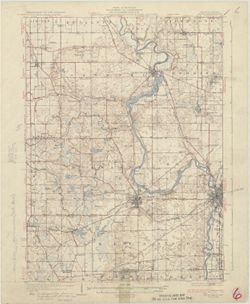
Topography by W.S. Gehres and A.W. Plushnick. Filing title: Niles, Mich.-Ind. Edition of 1930. Polyconic projection. Relief shown by contours and spot height...
Call Number:
G4090 s62 .G4 Niles 1930
Caption:
Imprint: Washington, D.C. : Dept. of the Interior, U.S. Geological Survey, 1930
Physical Description:
Dimensions: 45 x 42 cm or smaller and Scale: 1:62,500
H.M. Wilson and Jno. H. Renshawe, geographers in charge, topography by W.H. Lovell and Chas. W. Goodlove , control by Geo. T. Hawkins , engraved Mar. 1905 by...
Call Number:
G4090 s62 .G4 Newburg 1905 rep 1944
Caption:
Imprint: [Washington, D.C.] : U.S. Geological Survey, [1905]
Physical Description:
Scale: 1:62,500 and Dimensions: 45 x 42 cm or smaller
H.M. Wilson and Jno. H. Renshawe, geographers in charge, topography by W.H. Lovell and Chas. W. Goodlove , control by Geo. T. Hawkins , engraved Mar. 1905 by...
Call Number:
G4090 s62 .G4 1905 rep 1921
Caption:
Imprint: [Washington, D.C.] : U.S. Geological Survey, 1921.
Physical Description:
Scale: 1:62,500 and Dimensions: 45 x 42 cm or smaller
Topical Subject: Vegetation mapping, Geographic Subject: Posey County (Ind.), Geographic Subject: Gallatin County (Ill.), Geographic Subject: White County (I...
Creator:
Geological Survey (U.S.)
Publisher:
Geological Survey (U.S.)
Date Created:
1958
Identifier:
VAC3073-M-01360
Genre:
Topographic maps, 15 minute topographic maps, and Quadrangle maps
United States, Department of the Interior, Geological Survey , State of Illinois, Department of Registration and Education, Geological Survey Division , Stat...
Geographic Subject: Union County (Ky.), Geographic Subject: Gallatin County (Ill.), Geographic Subject: White County (Ill.), and Geographic Subject: Posey Co...
Creator:
Geological Survey (U.S.)
Publisher:
Geological Survey (U.S.)
Date Created:
1939
Identifier:
VAC3073-M-01359
Genre:
Quadrangle maps, Topographic maps, and 15 minute topographic maps
United States, Department of the Interior, Geological Survey , State of Illinois, Department of Registration and Education, Geological Survey Division , Stat...
Call Number:
G4090 s62 .G4 New Haven 1906 rep 1939
Caption:
Imprint: [Washington, D.C.] : U.S. Geological Survey, [1939]
Physical Description:
Dimensions: 45 x 42 cm or smaller and Scale: 1:62,500
Geographic Subject: Posey County (Ind.), Geographic Subject: White County (Ill.), and Geographic Subject: Gallatin County (Ill.)
Creator:
Lloyd, W. J. (Topographer), Kentucky Geological Survey, Smith, L. Scott, Ellis, J. R. (Topographer), Cooke, Chas. E. (Charles E.), Illinois State Geological ...
Publisher:
Geological Survey (U.S.)
Date Created:
1920
Identifier:
VAC3073-M-01358
Genre:
Topographic maps, 15 minute topographic maps, and Quadrangle maps
H. M. Wilson, chief geographer , Chas. E. Cooke, in charge of section , topography by W. J. Lloyd and L. Scott Smith , control by J. R. Ellis , engraved Aug....
Geographic Subject: Posey County (Ind.), Geographic Subject: White County (Ill.), Geographic Subject: Union County (Ky.), Geographic Subject: Gallatin County...
Creator:
Lloyd, W. J. (Topographer), Smith, L. Scott, Illinois State Geological Survey, Wilson, Herbert M. (Herbert Michael), 1860-1920, Ellis, J. R. (Topographer), C...
Publisher:
Geological Survey (U.S.)
Date Created:
1966
Identifier:
VAC3073-M-01357
Genre:
Quadrangle maps, Topographic maps, and 15 minute topographic maps
United States, Department of the Interior, Geological Survey , State of Illinois, Department of Registration and Education, Geological Survey Division , Stat...
Topical Subject: Vegetation mapping, Geographic Subject: Gibson County (Ind.), Geographic Subject: Posey County (Ind.), and Geographic Subject: White County ...
Creator:
Geological Survey (U.S.) and Illinois State Geological Survey
Publisher:
Geological Survey (U.S.)
Date Created:
1963
Identifier:
VAC3073-M-01356
Genre:
Topographic maps, Quadrangle maps, and 15 minute topographic maps
Mapped, edited, and published by the Geological Survey , Illinois area mapped in cooperation with State of Illinois Geological Survey. Filing title: New Harm...
Geographic Subject: Gibson County (Ind.), Geographic Subject: Posey County (Ind.), Geographic Subject: Wabash County (Ill.), and Geographic Subject: White Co...
Creator:
Goodlove, C. W., Renshawe, John H., Hawkins, Geo. T. (George T.), and Geological Survey (U.S.)
Publisher:
Geological Survey (U.S.)
Date Created:
1942
Identifier:
VAC3073-M-01355
Genre:
15 minute topographic maps, Quadrangle maps, and Topographic maps
John. H. Renshawe, geographer in charge , control by Geo. T. Hawkins , topography by Chas. W. Goodlove , engraved April 1903 by U.S.G.S. Filing title: New Ha...
Call Number:
G4090 s62 .G4 New Harmony 1903 rep 1942
Caption:
Imprint: [Washington, D.C.] : U.S. Geological Survey, 1942
Physical Description:
Scale: 1:62,500 and Dimensions: 45 x 42 cm or smaller

![Kentucky-Indiana Newburg quadrangle [1944 reprint]](https://iiif.uits.iu.edu/iiif/2/2227ns88j%2Ffiles%2Ffa6f73de-96dc-4cea-88ae-5a429c8c2522/full/250,/0/default.jpg)
![Kentucky-Indiana Newburg quadrangle [1921 reprint]](https://iiif.uits.iu.edu/iiif/2/xd07hx325%2Ffiles%2F7f7773e3-968f-4af7-8c0f-2cfd86527969/full/250,/0/default.jpg)
![Indiana, 15 minute series (topographic), New Haven quadrangle [1958 printing with vegetation]](https://iiif.uits.iu.edu/iiif/2/2514pp79t%2Ffiles%2F0d5ff364-2218-4a66-8b60-6f38aa96fe7f/full/250,/0/default.jpg)
![Illinois-Indiana-Kentucky, New Haven quadrangle [1939 reprint without vegetation]](https://iiif.uits.iu.edu/iiif/2/qj72qc053%2Ffiles%2Fbde64e1d-6659-4d18-a8c8-db54ce923770/full/250,/0/default.jpg)
![Illinois-Indiana-Kentucky, New Haven quadrangle : topography [1920 reprint without vegetation]](https://iiif.uits.iu.edu/iiif/2/pz50hz88n%2Ffiles%2Ff9ee1b77-e188-458e-ba78-5dd112ba1556/full/250,/0/default.jpg)
![Illinois-Indiana-Kentucky, New Haven quadrangle [1966 reprint with vegetation]](https://iiif.uits.iu.edu/iiif/2/k0699966z%2Ffiles%2F2ec905c7-1ce1-46fe-974b-b888b96b34a5/full/250,/0/default.jpg)
![New Harmony quadrangle, Indiana--Illinois, 1959 : 15 minute series (topographic) [1963 reprint with vegetation]](https://iiif.uits.iu.edu/iiif/2/n296z235w%2Ffiles%2Faf8714ac-51b2-4e50-bb3a-3e3e07d338a7/full/250,/0/default.jpg)
![Indiana-Illinois, New Harmony quadrangle [1942 reprint without vegetation]](https://iiif.uits.iu.edu/iiif/2/7m01cp450%2Ffiles%2F687ca4a9-29c4-4fc4-88d4-234e6f47aa32/full/250,/0/default.jpg)
