
Search Constraints
Search Results
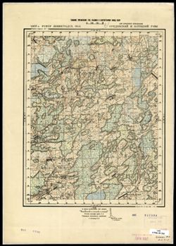
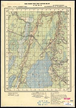
-
- Description:
- 1930
- Subject:
- Topical Subject: Soviet Union, Geographic Subject: Krasnopavlivka, and Topical Subject: Maps
- Publisher:
- Генеральный штаб Красной Армии
- Language:
- Russian
- Date Created:
- 1941
- Identifier:
- VAC9619-003396
- Genre:
- Military Maps and Topographic Maps
- Geographic Location:
- Coordinates: 49, 36, 49.333, 36.5
- Related URL:
- Catalog URL: https://iucat.iu.edu/catalog/5020129 and Download GeoTIFF: https://drive.google.com/file/d/1L9JwL8EhWzf2Jg5kPcpE5Tp6l0jzzwg9/view?usp=sharing
- Abstract:
- Modern area represented: Krasnopavlivka, Kharkiv oblast, Ukraine
- Call Number:
- G7000 s100 .S7 sheet M-37-97
- Caption:
- Для служебного пользования
- City:
- Краснопавловка (Krasnopavlivka)
- Copyright Holder:
- No Copyright - United States
- Country:
- СССР (USSR)
- State/Province:
- Украинская ССР (Ukrainian Soviet Socialist Republic)
- Physical Description:
- Scale: 1:100,000
- Persistent URL:
- http://purl.dlib.indiana.edu/iudl/images/VAC9619/VAC9619-003396
- Provenance:
- Army Map Service Library, Library of Congress G & M Division
-
- Description:
- 1934
- Subject:
- Topical Subject: Maps, Geographic Subject: Veshenskaya, and Topical Subject: Soviet Union
- Publisher:
- Генеральный штаб Красной Армии
- Language:
- Russian
- Date Created:
- 1941
- Identifier:
- VAC9619-003395
- Genre:
- Military Maps and Topographic Maps
- Geographic Location:
- Coordinates: 49.333, 41.5, 49.667, 42
- Related URL:
- Download GeoTIFF: https://drive.google.com/file/d/1ZLHQ5E-QuzTjkWQZpGH0YzqZv8Go0O-e/view?usp=sharing and Catalog URL: https://iucat.iu.edu/catalog/5020129
- Abstract:
- Modern area represented: Veshenskaya, Rostov oblast, Russia
- Call Number:
- G7000 s100 .S7 sheet M-37-96
- Caption:
- Для служебного пользования
- City:
- Вешенская (Veshenskaya)
- Copyright Holder:
- No Copyright - United States
- Country:
- СССР (USSR)
- State/Province:
- РСФСР (RSFSR) and Ростовская область (Rostov oblast)
- Physical Description:
- Scale: 1:100,000
- Persistent URL:
- http://purl.dlib.indiana.edu/iudl/images/VAC9619/VAC9619-003395
- Provenance:
- Army Map Service Library, Library of Congress G & M Division, Geographic Names Branch, Reichsamt für Landesaufnahme, Kartensammlung
-
- Description:
- 1928
- Subject:
- Topical Subject: Soviet Union, Topical Subject: Maps, and Geographic Subject: Mrykhovskiy
- Publisher:
- Генеральный штаб Красной Армии
- Language:
- Russian
- Date Created:
- 1941
- Identifier:
- VAC9619-003394
- Genre:
- Topographic Maps and Military Maps
- Geographic Location:
- Coordinates: 49.333, 41, 49.667, 41.5
- Related URL:
- Download GeoTIFF: https://drive.google.com/file/d/1nhjWneLuMZ5Z3-GQWznmSi_437ySmxOt/view?usp=sharing and Catalog URL: https://iucat.iu.edu/catalog/5020129
- Abstract:
- Modern area represented: Mrykhovskiy, Rostov oblast, Russia
- Call Number:
- G7000 s100 .S7 sheet M-37-95
- Caption:
- Для служебного пользования
- City:
- Мрыхин (Mrykhin)
- Copyright Holder:
- No Copyright - United States
- Country:
- СССР (USSR)
- State/Province:
- РСФСР (RSFSR) and Ростовская область (Rostov oblast)
- Physical Description:
- Scale: 1:100,000
- Persistent URL:
- http://purl.dlib.indiana.edu/iudl/images/VAC9619/VAC9619-003394
- Provenance:
- Army Map Service Library, Library of Congress G & M Division, Geographic Names Branch
-
- Description:
- 1928
- Subject:
- Topical Subject: Soviet Union, Topical Subject: Maps, and Geographic Subject: Boguchar
- Publisher:
- Генеральный штаб Красной Армии
- Language:
- Russian
- Date Created:
- 1941
- Identifier:
- VAC9619-003391
- Genre:
- Military Maps and Topographic Maps
- Geographic Location:
- Coordinates: 49.667, 40.5, 50, 41
- Related URL:
- Catalog URL: https://iucat.iu.edu/catalog/5020129 and Download GeoTIFF: https://drive.google.com/file/d/1KyprD1gW5Yf9zAnok6GTFsPaGYI1iJtf/view?usp=sharing
- Abstract:
- Modern area represented: Boguchar, Voronezh oblast, Russia
- Call Number:
- G7000 s100 .S7 sheet M-37-82
- City:
- Богучар (Boguchar)
- Copyright Holder:
- No Copyright - United States
- Country:
- СССР (USSR)
- State/Province:
- Ростовская область (Rostov oblast), РСФСР (RSFSR), and Воронежская область (Voronezh oblast)
- Physical Description:
- Scale: 1:100,000
- Persistent URL:
- http://purl.dlib.indiana.edu/iudl/images/VAC9619/VAC9619-003391
- Provenance:
- DMA Topographic Center, Army Map Service Library, OMAHA, Library of Congress Geography & Map Division, Auswärtiges Amt. Geographischer Dienst
-
- Description:
- 1938
- Subject:
- Topical Subject: Maps, Topical Subject: Soviet Union, and Geographic Subject: Vilkhuvatka
- Publisher:
- Главное Управление Геодезии и Картографии при СНК СССР
- Language:
- Russian
- Date Created:
- 1941
- Identifier:
- VAC9619-003389
- Genre:
- Topographic Maps and Military Maps
- Geographic Location:
- Coordinates: 50, 37.5, 50.333, 38
- Related URL:
- Catalog URL: https://iucat.iu.edu/catalog/5020129 and Download GeoTIFF: https://drive.google.com/file/d/1I0vQLmxbNuv6OkkXNI5DLf5ve3-7MBIK/view?usp=sharing
- Abstract:
- Modern area represented: Vilkhuvatka, Kharkiv oblast, Ukraine
- Call Number:
- G7000 s100 .S7 sheet M-37-64
- Caption:
- Для служебного пользования
- City:
- Ольховатка (Olkhovatka)
- Copyright Holder:
- No Copyright - United States
- Country:
- СССР (USSR)
- State/Province:
- Харьковская область (Kharkiv oblast), Украинская ССР (Ukrainian Soviet Socialist Republic), РСФСР (RSFSR), and Курская область (Kursk oblast)
- Physical Description:
- Scale: 1:100,000
- Persistent URL:
- http://purl.dlib.indiana.edu/iudl/images/VAC9619/VAC9619-003389
- Provenance:
- DMA Topographic Center, Army Map Service Library, Library of Congress Geography & Map Division
-
- Description:
- 1929
- Subject:
- Geographic Subject: Derhachi, Topical Subject: Soviet Union, and Topical Subject: Maps
- Publisher:
- Генеральный штаб Красной Армии
- Language:
- Russian
- Date Created:
- 1941
- Identifier:
- VAC9619-003388
- Genre:
- Topographic Maps and Military Maps
- Geographic Location:
- Coordinates: 50, 36, 50.333, 36.5
- Related URL:
- Catalog URL: https://iucat.iu.edu/catalog/5020129 and Download GeoTIFF: https://drive.google.com/file/d/1_5nhCPC3E-jfDcJk-rDeFvngeE9VgOZG/view?usp=sharing
- Abstract:
- Modern area represented: Derhachi, Kharkiv oblast, Ukraine
- Call Number:
- G7000 s100 .S7 sheet M-37-61
- Caption:
- Секретно
- City:
- Дергачи (Derhachi)
- Copyright Holder:
- No Copyright - United States
- Country:
- СССР (USSR)
- State/Province:
- Курская область (Kursk oblast), Украинская ССР (Ukrainian Soviet Socialist Republic), РСФСР (RSFSR), and Харьковская область (Kharkiv oblast)
- Physical Description:
- Scale: 1:100,000
- Persistent URL:
- http://purl.dlib.indiana.edu/iudl/images/VAC9619/VAC9619-003388
- Provenance:
- Army Map Service Library, Library of Congress G & M Division, Geographic Names Branch
-
- Description:
- 1940
- Subject:
- Geographic Subject: Bolshetroitskoye, Topical Subject: Soviet Union, and Topical Subject: Maps
- Publisher:
- Главное Управление Геодезии и Картографии при СНК СССР
- Language:
- Russian
- Date Created:
- 1941
- Identifier:
- VAC9619-003387
- Genre:
- Military Maps and Topographic Maps
- Geographic Location:
- Coordinates: 50.333, 37, 50.667, 37.5
- Related URL:
- Download GeoTIFF: https://drive.google.com/file/d/1Sy1mBMGYvqqz0pzlHcvGjxKjo3ANez5Y/view?usp=sharing and Catalog URL: https://iucat.iu.edu/catalog/5020129
- Abstract:
- Modern area represented: Bolshetroitskoye, Belgorod oblast, Russia
- Call Number:
- G7000 s100 .S7 sheet M-37-51
- City:
- Больше-Троицкое (Bolshe-Troitskoye)
- Copyright Holder:
- No Copyright - United States
- Country:
- СССР (USSR)
- State/Province:
- Харьковская область (Kharkiv oblast), Курская область (Kursk oblast), Украинская ССР (Ukrainian Soviet Socialist Republic), and РСФСР (RSFSR)
- Physical Description:
- Scale: 1:100,000
- Persistent URL:
- http://purl.dlib.indiana.edu/iudl/images/VAC9619/VAC9619-003387
- Provenance:
- Army Map Service Library, Library of Congress G & M Division, Geographic Names Branch
-
- Description:
- 1929
- Subject:
- Topical Subject: Maps, Topical Subject: Soviet Union, and Geographic Subject: Uryupinsk
- Publisher:
- Генеральный штаб Красной Армии
- Language:
- Russian
- Date Created:
- 1941
- Identifier:
- VAC9619-003386
- Genre:
- Military Maps and Topographic Maps
- Geographic Location:
- Coordinates: 50.667, 41.5, 51, 42
- Related URL:
- Catalog URL: https://iucat.iu.edu/catalog/5020129 and Download GeoTIFF: https://drive.google.com/file/d/1PNCCYMJtTWMLNJqrvKzcjifqrkcbvHVN/view?usp=sharing
- Abstract:
- Modern area represented: Uryupinsk, Volgograd oblast, Russia
- Call Number:
- G7000 s100 .S7 sheet M-37-48
- City:
- Урюпинск (Uryupinsk)
- Copyright Holder:
- No Copyright - United States
- Country:
- СССР (USSR)
- State/Province:
- РСФСР (RSFSR), Сталинградская область (Stalingrad oblast), and Воронежская область (Voronezh oblast)
- Physical Description:
- Scale: 1:100,000
- Persistent URL:
- http://purl.dlib.indiana.edu/iudl/images/VAC9619/VAC9619-003386
- Provenance:
- DMA Topographic Center, Army Map Service Library, OMAHA, Library of Congress Geography & Map Division
-
- Description:
- 1866
- Subject:
- Topical Subject: Maps, Geographic Subject: Talovaya, and Topical Subject: Soviet Union
- Publisher:
- Генеральный штаб Красной Армии
- Language:
- Russian
- Date Created:
- 1941
- Identifier:
- VAC9619-003383
- Genre:
- Topographic Maps and Military Maps
- Geographic Location:
- Coordinates: 51, 40.5, 51.333, 41
- Related URL:
- Download GeoTIFF: https://drive.google.com/file/d/1peilkCpSK42KmJAUjfSAZOQmVy70L1C1/view?usp=sharing and Catalog URL: https://iucat.iu.edu/catalog/5020129
- Abstract:
- Modern area represented: Talovaya, Voronezh oblast, Russia
- Call Number:
- G7000 s100 .S7 sheet M-37-34
- City:
- Таловая (Talovaya)
- Copyright Holder:
- No Copyright - United States
- Country:
- СССР (USSR)
- State/Province:
- РСФСР (RSFSR) and Воронежская область (Voronezh oblast)
- Physical Description:
- Scale: 1:100,000
- Persistent URL:
- http://purl.dlib.indiana.edu/iudl/images/VAC9619/VAC9619-003383
- Provenance:
- DMA Topographic Center, Library of Congress G & M Division, Army Map Service Library
-
- Description:
- 1940
- Subject:
- Topical Subject: Soviet Union, Topical Subject: Maps, and Geographic Subject: Skorodnoye
- Publisher:
- Главное Управление Геодезии и Картографии при СНК СССР
- Language:
- Russian
- Date Created:
- 1941
- Identifier:
- VAC9619-003381
- Genre:
- Military Maps and Topographic Maps
- Geographic Location:
- Coordinates: 51, 37, 51.333, 37.5
- Related URL:
- Catalog URL: https://iucat.iu.edu/catalog/5020129 and Download GeoTIFF: https://drive.google.com/file/d/1G4UWnnJBbvVb-WtNuv95PPm_L8Co7z7m/view?usp=sharing
- Abstract:
- Modern area represented: Skorodnoye, Kursk oblast, Russia
- Call Number:
- G7000 s100 .S7 sheet M-37-27
- City:
- Скородное (Skorodnoye)
- Copyright Holder:
- No Copyright - United States
- Country:
- СССР (USSR)
- State/Province:
- РСФСР (RSFSR) and Курская область (Kursk oblast)
- Physical Description:
- Scale: 1:100,000
- Persistent URL:
- http://purl.dlib.indiana.edu/iudl/images/VAC9619/VAC9619-003381
- Provenance:
- DMA Topographic Center, Army Map Service Library, OMAHA, Library of Congress Geography & Map Division
-
- Description:
- 1940
- Subject:
- Topical Subject: Maps, Geographic Subject: Tim, and Topical Subject: Soviet Union
- Publisher:
- Генеральный штаб Красной Армии
- Language:
- Russian
- Date Created:
- 1941
- Identifier:
- VAC9619-003379
- Genre:
- Military Maps and Topographic Maps
- Geographic Location:
- Coordinates: 51.333, 37, 51.667, 37.5
- Related URL:
- Catalog URL: https://iucat.iu.edu/catalog/5020129 and Download GeoTIFF: https://drive.google.com/file/d/11O_MqZ_ehlt0WHSK7Ol9asTc0b08MIkG/view?usp=sharing
- Abstract:
- Modern area represented: Tim, Kursk oblast, Russia
- Call Number:
- G7000 s100 .S7 sheet M-37-15
- Caption:
- Для служебного пользования
- City:
- Тим (Tim)
- Copyright Holder:
- No Copyright - United States
- Country:
- СССР (USSR)
- State/Province:
- Курская область (Kursk oblast) and РСФСР (RSFSR)
- Physical Description:
- Scale: 1:100,000
- Persistent URL:
- http://purl.dlib.indiana.edu/iudl/images/VAC9619/VAC9619-003379
- Provenance:
- DMA Topographic Center, Army Map Service Library, OMAHA, Library of Congress Geography & Map Division
-
- Description:
- 1940
- Subject:
- Topical Subject: Maps, Geographic Subject: Pokrovskoye, and Topical Subject: Soviet Union
- Publisher:
- Генеральный штаб Красной Армии
- Language:
- Russian
- Date Created:
- 1941
- Identifier:
- VAC9619-003377
- Genre:
- Topographic Maps and Military Maps
- Geographic Location:
- Coordinates: 51.667, 37, 52, 37.5
- Related URL:
- Download GeoTIFF: https://drive.google.com/file/d/1xwM6H6ObgtKpGsMUyVS0QN4disC5D8l0/view?usp=sharing and Catalog URL: https://iucat.iu.edu/catalog/5020129
- Abstract:
- Modern area represented: Pokrovskoye, Kursk oblast, Russia
- Call Number:
- G7000 s100 .S7 sheet M-37-3
- City:
- Покровское (Pokrovskoye)
- Copyright Holder:
- No Copyright - United States
- Country:
- СССР (USSR)
- State/Province:
- РСФСР (RSFSR) and Курская область (Kursk oblast)
- Physical Description:
- Scale: 1:100,000
- Persistent URL:
- http://purl.dlib.indiana.edu/iudl/images/VAC9619/VAC9619-003377
- Provenance:
- Army Map Service Library, Library of Congress G & M Division, Geographic Names Branch
-
- Description:
- 1939
- Subject:
- Topical Subject: Maps, Geographic Subject: Torbino, and Topical Subject: Soviet Union
- Publisher:
- Главное управление геодезии и картографии при СНК СССР
- Language:
- Russian
- Date Created:
- 1941
- Identifier:
- VAC9619-003374
- Genre:
- Military Maps and Topographic Maps
- Geographic Location:
- Coordinates: 58.5, 32.75, 58.667, 33
- Related URL:
- Download GeoTIFF: https://drive.google.com/file/d/1REcpv4d51hjjI3DlbpCjUEu2PCsUgHsu/view?usp=sharing and Catalog URL: http://iucat.iu.edu/catalog/5020131
- Abstract:
- Modern area represented: Торбино (Torbino), Novgorodskaya oblast, Russia
- Call Number:
- G7000 s50 .S68 sheet O-36-54-B
- Caption:
- Для служебного пользования and Captured map
- City:
- Торбино (Torbino)
- Copyright Holder:
- No Copyright - United States
- Country:
- СССР (USSR)
- State/Province:
- Ленинградская область (Leningrad oblast)
- Physical Description:
- Scale: 1:50,000
- Persistent URL:
- http://purl.dlib.indiana.edu/iudl/images/VAC9619/VAC9619-003374
- Provenance:
- DMA Topographic Center, Army Map Service Library, OMAHA, Library of Congress Geography & Map Division
-
- Description:
- 1937
- Subject:
- Topical Subject: Soviet Union, Geographic Subject: Lyubolyady, and Topical Subject: Maps
- Publisher:
- Главное управление геодезии и картографии при СНК СССР
- Language:
- Russian
- Date Created:
- 1941
- Identifier:
- VAC9619-003363
- Genre:
- Military Maps and Topographic Maps
- Geographic Location:
- Coordinates: 58.5, 30.75, 58.667, 31
- Related URL:
- Catalog URL: http://iucat.iu.edu/catalog/5020131 and Download GeoTIFF: https://drive.google.com/file/d/1ZDggAdZ_3laR_snLCNc-7jxa2T1MoShO/view?usp=sharing
- Abstract:
- Modern area represented: Люболяды (Lyubolyady), Novgorodskaya oblast, Russia
- Call Number:
- G7000 s50 .S68 sheet O-36-50-B
- Caption:
- Для служебного пользования and Captured map
- City:
- Люболяды (Lyubolyady)
- Copyright Holder:
- No Copyright - United States
- Country:
- СССР (USSR)
- State/Province:
- Новгородский район (Novgorod district), Ленинградская область (Leningrad oblast), РСФСР (RSFSR), and Батецкий район (Batetsky district)
- Physical Description:
- Scale: 1:50,000
- Persistent URL:
- http://purl.dlib.indiana.edu/iudl/images/VAC9619/VAC9619-003363
- Provenance:
- DMA Topographic Center, Army Map Service Library, OMAHA, Library of Congress Geography & Map Division
-
- Description:
- 1936
- Subject:
- Topical Subject: Soviet Union, Topical Subject: Maps, and Geographic Subject: Burga
- Publisher:
- Главное управление государственной съемки и картографии НКВД СССР
- Language:
- Russian
- Date Created:
- 1941
- Identifier:
- VAC9619-003353
- Genre:
- Military Maps and Topographic Maps
- Geographic Location:
- Coordinates: 58.667, 32.25, 58.833, 32.5
- Related URL:
- Download GeoTIFF: https://drive.google.com/file/d/1jDFXLd8FB4_pZaY0B9_cVM1Zh4ibtoky/view?usp=sharing and Catalog URL: http://iucat.iu.edu/catalog/5020131
- Abstract:
- Modern area represented: Бурга (Burga), Novgorodskaya oblast, Russia
- Call Number:
- G7000 s50 .S68 sheet O-36-41-D
- Caption:
- Captured map and Для служебного пользования
- City:
- Бурга (Burga)
- Copyright Holder:
- No Copyright - United States
- Country:
- СССР (USSR)
- State/Province:
- РСФСР (RSFSR), Ленинградская область (Leningrad oblast), and Маловишерский район (Malovishersky district)
- Physical Description:
- Scale: 1:50,000
- Persistent URL:
- http://purl.dlib.indiana.edu/iudl/images/VAC9619/VAC9619-003353
- Provenance:
- Army Map Service Library, OMAHA, Library of Congress Geography & Map Division
-
- Description:
- 1936
- Subject:
- Topical Subject: Soviet Union, Topical Subject: Maps, and Geographic Subject: Glutno
- Publisher:
- Главное управление государственной съемки и картографии НКВД СССР
- Language:
- Russian
- Date Created:
- 1941
- Identifier:
- VAC9619-003352
- Genre:
- Military Maps and Topographic Maps
- Geographic Location:
- Coordinates: 58.667, 32, 58.833, 32.25
- Related URL:
- Download GeoTIFF: https://drive.google.com/file/d/1--cVDDhZJZlZhbOr4z4CmcrTGL8dblq0/view?usp=sharing and Catalog URL: http://iucat.iu.edu/catalog/5020131
- Abstract:
- Modern area represented: Глутно (Glutno), Novgorodskaya oblast, Russia
- Call Number:
- G7000 s50 .S68 sheet O-36-41-C
- Caption:
- Для служебного пользования and Captured map
- City:
- Глутно (Glutno)
- Copyright Holder:
- No Copyright - United States
- Country:
- СССР (USSR)
- State/Province:
- Маловишерский район (Malovishersky district), РСФСР (RSFSR), and Ленинградская область (Leningrad oblast)
- Physical Description:
- Scale: 1:50,000
- Persistent URL:
- http://purl.dlib.indiana.edu/iudl/images/VAC9619/VAC9619-003352
- Provenance:
- Army Map Service Library, OMAHA, Library of Congress Geography & Map Division
-
- Description:
- 1936
- Subject:
- Topical Subject: Maps, Geographic Subject: Pustaya Visherka, and Topical Subject: Soviet Union
- Publisher:
- Главное управление государственной съемки и картографии НКВД СССР
- Language:
- Russian
- Date Created:
- 1941
- Identifier:
- VAC9619-003351
- Genre:
- Military Maps and Topographic Maps
- Geographic Location:
- Coordinates: 58.833, 32.25, 59, 32.5
- Related URL:
- Catalog URL: http://iucat.iu.edu/catalog/5020131 and Download GeoTIFF: https://drive.google.com/file/d/1HAbz9xPIPMxBjtR5SOgZydbei2skVOnc/view?usp=sharing
- Abstract:
- Modern area represented: Пустая Вишерка (Pustaya Visherka), Novgorodskaya oblast, Russia
- Call Number:
- G7000 s50 .S68 sheet O-36-41-B
- Caption:
- Captured map and Для служебного пользования
- City:
- Пустая Вишерка (Pustaya Visherka)
- Copyright Holder:
- No Copyright - United States
- Country:
- СССР (USSR)
- State/Province:
- Ленинградская область (Leningrad oblast), Маловишерский район (Malovishersky district), and РСФСР (RSFSR)
- Physical Description:
- Scale: 1:50,000
- Persistent URL:
- http://purl.dlib.indiana.edu/iudl/images/VAC9619/VAC9619-003351
- Provenance:
- Army Map Service Library, OMAHA, Library of Congress Geography & Map Division
-
- Description:
- 1937
- Subject:
- Geographic Subject: Gryady, Topical Subject: Soviet Union, and Topical Subject: Maps
- Publisher:
- Главное управление государственной съемки и картографии НКВД СССР
- Language:
- Russian
- Date Created:
- 1941
- Identifier:
- VAC9619-003347
- Genre:
- Military Maps and Topographic Maps
- Geographic Location:
- Coordinates: 58.8333, 31.75, 59.0, 32.0
- Related URL:
- Catalog URL: http://iucat.iu.edu/catalog/5020131 and Download GeoTIFF: https://drive.google.com/file/d/1aeiZH_9uDvFMa2A_cDn0OgJXzFkZbzux/view?usp=sharing
- Abstract:
- Modern area represented: Гряды (Gryady), Novgorodskaya oblast, Russia
- Call Number:
- G7000 s50 .S68 sheet O-36-40-B
- Caption:
- Captured map and Для служебного пользования
- City:
- Гряды (Gryady)
- Copyright Holder:
- No Copyright - United States
- Country:
- СССР (USSR)
- State/Province:
- Чудовский район (Chudovsky district), Ленинградская область (Leningrad oblast), Маловишерский район (Malovishersky district), and РСФСР (RSFSR)
- Physical Description:
- Scale: 1:50,000
- Persistent URL:
- http://purl.dlib.indiana.edu/iudl/images/VAC9619/VAC9619-003347
- Provenance:
- Army Map Service Library, OMAHA, Library of Congress Geography & Map Division
-
- Description:
- 1937
- Subject:
- Topical Subject: Soviet Union, Topical Subject: Maps, and Geographic Subject: Myasnoy Bor
- Publisher:
- Главное управление государственной съемки и картографии НКВД СССР
- Language:
- Russian
- Date Created:
- 1941
- Identifier:
- VAC9619-003345
- Genre:
- Military Maps and Topographic Maps
- Geographic Location:
- Coordinates: 58.667, 31.25, 58.833, 31.5
- Related URL:
- Download GeoTIFF: https://drive.google.com/file/d/1AOKF0KjNQCHxRxzaiZYQ_QZVRE_YKJ0x/view?usp=sharing and Catalog URL: http://iucat.iu.edu/catalog/5020131
- Abstract:
- Modern area represented: Мясной Бор (Myasnoy Bor), Novgorodskaya oblast, Russia
- Call Number:
- G7000 s50 .S68 sheet O-36-39-D
- Caption:
- Для служебного пользования
- City:
- Мясной Бор (Myasnoy Bor)
- Copyright Holder:
- No Copyright - United States
- Country:
- СССР (USSR)
- State/Province:
- Ленинградская область (Leningrad oblast), Чудовский район (Chudovsky district), РСФСР (RSFSR), and Новгородский район (Novgorod district)
- Physical Description:
- Scale: 1:50,000
- Persistent URL:
- http://purl.dlib.indiana.edu/iudl/images/VAC9619/VAC9619-003345
- Provenance:
- Army Map Service Library, OMAHA, Library of Congress Geography & Map Division
-
- Description:
- 1937
- Subject:
- Topical Subject: Maps, Topical Subject: Soviet Union, and Geographic Subject: Lyubino Pole
- Publisher:
- Главное управление государственной съемки и картографии НКВД СССР
- Language:
- Russian
- Date Created:
- 1941
- Identifier:
- VAC9619-003343
- Genre:
- Topographic Maps and Military Maps
- Geographic Location:
- Coordinates: 58.833, 31.25, 59, 31.5
- Related URL:
- Catalog URL: http://iucat.iu.edu/catalog/5020131 and Download GeoTIFF: https://drive.google.com/file/d/1QFT85SnbI5qOZrFuFtShvHDkF3s_RVfW/view?usp=sharing
- Abstract:
- Modern area represented: Любино Поле (Lyubino Pole), Novgorodskaya oblast, Russia
- Call Number:
- G7000 s50 .S68 sheet O-36-39-B
- Caption:
- Секретно
- City:
- Любино Поле (Lyubino Pole)
- Copyright Holder:
- No Copyright - United States
- Country:
- СССР (USSR)
- State/Province:
- РСФСР (RSFSR), Ленинградская область (Leningrad oblast), Новгородский район (Novgorod district), Чудовский район (Chudovsky district), and Тосненский район (...
- Physical Description:
- Scale: 1:50,000
- Persistent URL:
- http://purl.dlib.indiana.edu/iudl/images/VAC9619/VAC9619-003343
- Provenance:
- Army Map Service Library, OMAHA, Library of Congress Geography & Map Division
-
- Description:
- 1937
- Subject:
- Topical Subject: Maps, Topical Subject: Soviet Union, and Geographic Subject: Finev Lug
- Publisher:
- Главное управление государственной съемки и картографии НКВД СССР
- Language:
- Russian
- Date Created:
- 1941
- Identifier:
- VAC9619-003342
- Genre:
- Topographic Maps and Military Maps
- Geographic Location:
- Coordinates: 58.833, 31, 59, 31.25
- Related URL:
- Catalog URL: http://iucat.iu.edu/catalog/5020131 and Download GeoTIFF: https://drive.google.com/file/d/1AkA2uAA4OaKvyz_ylCOhhg3XWLq2Hrxc/view?usp=sharing
- Abstract:
- Modern area represented: Финев Луг (Finev Lug), Novgorodskaya oblast, Russia
- Call Number:
- G7000 s50 .S68 sheet O-36-39-A
- Caption:
- Секретно and Captured map
- City:
- Финев Луг (Finev Lug)
- Copyright Holder:
- No Copyright - United States
- Country:
- СССР (USSR)
- State/Province:
- РСФСР (RSFSR), Новгородский район (Novgorod district), Чудовский район (Chudovsky district), Тосненский район (Tosnensky district), and Ленинградская область...
- Physical Description:
- Scale: 1:50,000
- Persistent URL:
- http://purl.dlib.indiana.edu/iudl/images/VAC9619/VAC9619-003342
- Provenance:
- Army Map Service Library, OMAHA, Library of Congress Geography & Map Division
-
- Description:
- 1937
- Subject:
- Topical Subject: Soviet Union, Geographic Subject: Khrepelki, and Topical Subject: Maps
- Publisher:
- Главное управление государственной съемки и картографии НКВД СССР
- Language:
- Russian
- Date Created:
- 1941
- Identifier:
- VAC9619-003340
- Genre:
- Topographic Maps and Military Maps
- Geographic Location:
- Coordinates: 58.667, 30.5, 58.833, 30.75
- Related URL:
- Catalog URL: http://iucat.iu.edu/catalog/5020131 and Download GeoTIFF: https://iu.box.com/s/w35ypucd5dr86l1j9gkgtjqglvo7npt3
- Abstract:
- Modern area represented: Khrepelki, Leningrad oblast, Russia
- Call Number:
- G7000 s50 .S68 sheet O-36-38-C
- Caption:
- Для служебного пользования
- City:
- Хрепелки (Khrepelki)
- Copyright Holder:
- No Copyright - United States
- Country:
- СССР (USSR)
- State/Province:
- РСФСР (RSFSR), Ленинградская область (Leningrad oblast), Оредежский район (Oredezhsky district), and Батецкий район (Batetsky district)
- Physical Description:
- Scale: 1:50,000
- Persistent URL:
- http://purl.dlib.indiana.edu/iudl/images/VAC9619/VAC9619-003340
- Provenance:
- CIA Map Branch -- Received, CIA Map Branch -- Received
-
- Description:
- 1937
- Subject:
- Topical Subject: Maps, Topical Subject: Soviet Union, and Geographic Subject: Khrepelki
- Publisher:
- Главное управление государственной съемки и картографии НКВД СССР
- Language:
- Russian
- Date Created:
- 1941
- Identifier:
- VAC9619-003339
- Genre:
- Military Maps and Topographic Maps
- Geographic Location:
- Coordinates: 58.667, 30.5, 58.833, 30.75
- Related URL:
- Download GeoTIFF: https://drive.google.com/file/d/1rBADoeEk54H3My3s3VpcFM_f_2nR_EZn/view?usp=sharing and Catalog URL: http://iucat.iu.edu/catalog/5020131
- Abstract:
- Modern area represented: Khrepelki, Leningrad oblast, Russia
- Call Number:
- G7000 s50 .S68 sheet O-36-38-C
- Caption:
- Для служебного пользования
- City:
- Хрепелки (Khrepelki)
- Copyright Holder:
- No Copyright - United States
- Country:
- СССР (USSR)
- State/Province:
- РСФСР (RSFSR), Ленинградская область (Leningrad oblast), Батецкий район (Batetsky district), and Оредежский район (Oredezhsky district)
- Physical Description:
- Scale: 1:50,000
- Persistent URL:
- http://purl.dlib.indiana.edu/iudl/images/VAC9619/VAC9619-003339
- Provenance:
- Army Map Service Library, OMAHA, Library of Congress Geography & Map Division
-
- Description:
- 1936
- Subject:
- Topical Subject: Soviet Union, Geographic Subject: Glad', and Topical Subject: Maps
- Publisher:
- Главное управление государственной съемки и картографии НКВД СССР
- Language:
- Russian
- Date Created:
- 1941
- Identifier:
- VAC9619-003327
- Genre:
- Topographic Maps and Military Maps
- Geographic Location:
- Coordinates: 59, 32, 59.167, 32.25
- Related URL:
- Catalog URL: http://iucat.iu.edu/catalog/5020131 and Download GeoTIFF: https://drive.google.com/file/d/1BqOb5vZAvsaq96qdO5AqOa-kFKiCBYW6/view?usp=sharing
- Abstract:
- Modern area represented: Гладь (Glad'), Novgorodskaya oblast, Russia
- Call Number:
- G7000 s50 .S68 sheet O-36-29-C
- Caption:
- Для служебного пользования and Captured map
- City:
- Гладь (Glad')
- Copyright Holder:
- No Copyright - United States
- Country:
- СССР (USSR)
- State/Province:
- РСФСР (RSFSR), Ленинградская область (Leningrad oblast), Маловишерский район (Malovishersky district), and Чудовский район (Chudovsky district)
- Physical Description:
- Scale: 1:50,000
- Persistent URL:
- http://purl.dlib.indiana.edu/iudl/images/VAC9619/VAC9619-003327
- Provenance:
- Army Map Service Library, OMAHA, Library of Congress Geography & Map Division
-
- Description:
- 1936
- Subject:
- Topical Subject: Maps, Topical Subject: Soviet Union, and Geographic Subject: Glad'
- Publisher:
- Главное управление государственной съемки и картографии НКВД СССР
- Language:
- Russian
- Date Created:
- 1941
- Identifier:
- VAC9619-003326
- Genre:
- Military Maps and Topographic Maps
- Geographic Location:
- Coordinates: 59, 32, 59.167, 32.25
- Related URL:
- Catalog URL: http://iucat.iu.edu/catalog/5020131 and Download GeoTIFF: https://drive.google.com/file/d/1uQeqSrfffRYdboAdTqPVTHEerJ_HHoQF/view?usp=sharing
- Abstract:
- Modern area represented: Гладь (Glad'), Novgorodskaya oblast, Russia
- Call Number:
- G7000 s50 .S68 sheet O-36-29-C
- Caption:
- Для служебного пользования
- City:
- Гладь (Glad')
- Copyright Holder:
- No Copyright - United States
- Country:
- СССР (USSR)
- State/Province:
- Чудовский район (Chudovsky district), Маловишерский район (Malovishersky district), РСФСР (RSFSR), and Ленинградская область (Leningrad oblast)
- Physical Description:
- Scale: 1:50,000
- Persistent URL:
- http://purl.dlib.indiana.edu/iudl/images/VAC9619/VAC9619-003326
- Provenance:
- M. I. Map Library
-
- Description:
- 1936
- Subject:
- Topical Subject: Soviet Union, Topical Subject: Maps, and Geographic Subject: Oskuy
- Publisher:
- Главное управление государственной съемки и картографии НКВД СССР
- Language:
- Russian
- Date Created:
- 1941
- Identifier:
- VAC9619-003323
- Genre:
- Topographic Maps and Military Maps
- Geographic Location:
- Coordinates: 59.167, 32, 59.333, 32.25
- Related URL:
- Catalog URL: http://iucat.iu.edu/catalog/5020131 and Download GeoTIFF: https://drive.google.com/file/d/1j7QBueRwjCdZezODsPwdLCovxSXLuWXD/view?usp=sharing
- Abstract:
- Modern area represented: Oskuy, Novgorod oblast, Russia
- Call Number:
- G7000 s50 .S68 sheet O-36-29-A
- Caption:
- Для служебного пользования
- City:
- Оскуй (Oskuy)
- Copyright Holder:
- No Copyright - United States
- Country:
- СССР (USSR)
- State/Province:
- Чудовский район (Chudovsky district), РСФСР (RSFSR), Киришский район (Kirishsky district), and Ленинградская область (Leningrad oblast)
- Physical Description:
- Scale: 1:50,000
- Persistent URL:
- http://purl.dlib.indiana.edu/iudl/images/VAC9619/VAC9619-003323
- Provenance:
- DMA Topographic Center, Army Map Service Library, OMAHA, Library of Congress Geography & Map Division
-
- Description:
- 1937
- Subject:
- Geographic Subject: Sosninskaya Pristan’, Topical Subject: Soviet Union, and Topical Subject: Maps
- Publisher:
- Главное управление государственной съемки и картографии НКВД СССР
- Language:
- Russian
- Date Created:
- 1941
- Identifier:
- VAC9619-003322
- Genre:
- Topographic Maps and Military Maps
- Geographic Location:
- Coordinates: 59, 31.75, 59.167, 32
- Related URL:
- Download GeoTIFF: https://drive.google.com/file/d/1n2MvR88pVpOW-TP8eyFkS2qhEzS3coqJ/view?usp=sharing and Catalog URL: http://iucat.iu.edu/catalog/5020131
- Abstract:
- Modern area represented: Соснинская Пристань (Sosninskaya Pristan’), Novgorodskaya oblast, Russia
- Call Number:
- G7000 s50 .S68 sheet O-36-28-D
- Caption:
- Captured map and Для служебного пользования
- City:
- Соснинская Пристань (Sosninskaya Pristan’)
- Copyright Holder:
- No Copyright - United States
- Country:
- СССР (USSR)
- State/Province:
- РСФСР (RSFSR), Ленинградская область (Leningrad oblast), Маловишерский район (Malovishersky district), and Чудовский район (Chudovsky district)
- Physical Description:
- Scale: 1:50,000
- Persistent URL:
- http://purl.dlib.indiana.edu/iudl/images/VAC9619/VAC9619-003322
- Provenance:
- DMA Topographic Center, Army Map Service Library, OMAHA, Library of Congress Geography & Map Division
-
- Description:
- 1937
- Subject:
- Topical Subject: Maps, Geographic Subject: Vditsko, and Topical Subject: Soviet Union
- Publisher:
- Главное управление государственной съемки и картографии НКВД СССР
- Language:
- Russian
- Date Created:
- 1941
- Identifier:
- VAC9619-003317
- Genre:
- Military Maps and Topographic Maps
- Geographic Location:
- Coordinates: 59, 31, 59.167, 31.25
- Related URL:
- Catalog URL: http://iucat.iu.edu/catalog/5020131 and Download GeoTIFF: https://drive.google.com/file/d/1NM_x_MjJDqMX13qR8VPd7sFKdkVst2LK/view?usp=sharing
- Abstract:
- Modern area represented: Вдицко (Vditsko), Novgorodskaya oblast, Russia
- Call Number:
- G7000 s50 .S68 sheet O-36-27-C
- Caption:
- Captured map and Секретно
- City:
- Вдицко (Vditsko)
- Copyright Holder:
- No Copyright - United States
- Country:
- СССР (USSR)
- State/Province:
- РСФСР (RSFSR), Тосненский район (Tosnensky district), Ленинградская область (Leningrad oblast), and Новгородский район (Novgorod district)
- Physical Description:
- Scale: 1:50,000
- Persistent URL:
- http://purl.dlib.indiana.edu/iudl/images/VAC9619/VAC9619-003317
- Provenance:
- M. I. Map Library
-
- Description:
- 1929
- Subject:
- Geographic Subject: Kropyvnytskyi, Topical Subject: Maps, and Topical Subject: Soviet Union
- Publisher:
- Генеральный штаб Красной Армии
- Language:
- Russian
- Date Created:
- 1941
- Identifier:
- VAC9619-003306
- Genre:
- Topographic Maps and Military Maps
- Geographic Location:
- Coordinates: 48.333, 32, 48.667, 32.5
- Related URL:
- Catalog URL: https://iucat.iu.edu/catalog/5020129 and Download GeoTIFF: https://drive.google.com/file/d/1k7iBK8ifYXHJbN_6qN3O3HAUfuq6W9FC/view?usp=sharing
- Abstract:
- Modern area represented: Kropyvnytskyi, Kirovohrad oblast, Ukraine
- Call Number:
- G7000 s100 .S7 sheet M-36-125
- Caption:
- Для служебного пользования
- City:
- Кировоград (Kirovohrad)
- Copyright Holder:
- No Copyright - United States
- Country:
- СССР (USSR)
- State/Province:
- Украинская ССР (Ukrainian Soviet Socialist Republic)
- Physical Description:
- Scale: 1:100,000
- Persistent URL:
- http://purl.dlib.indiana.edu/iudl/images/VAC9619/VAC9619-003306
- Provenance:
- DMA Topographic Center, Army Map Service Library, OMAHA, Library of Congress Geography & Map Division
-
- Description:
- 1932
- Subject:
- Geographic Subject: Pavlohrad, Topical Subject: Soviet Union, and Topical Subject: Maps
- Publisher:
- Генеральный штаб Красной Армии
- Language:
- Russian
- Date Created:
- 1941
- Identifier:
- VAC9619-003307
- Genre:
- Topographic Maps and Military Maps
- Geographic Location:
- Coordinates: 48.333, 35.5, 48.667, 36
- Related URL:
- Download GeoTIFF: https://drive.google.com/file/d/1NobqFmlY1wgm4sjbbmPZp3tKMnnjHY7t/view?usp=sharing and Catalog URL: https://iucat.iu.edu/catalog/5020129
- Abstract:
- Modern area represented: Pavlohrad, Dnipropetrovsk oblast, Ukraine
- Call Number:
- G7000 s100 .S7 sheet M-36-132
- Caption:
- Для служебного пользования
- City:
- Павлоград (Pavlohrad)
- Copyright Holder:
- No Copyright - United States
- Country:
- СССР (USSR)
- State/Province:
- Украинская ССР (Ukrainian Soviet Socialist Republic)
- Physical Description:
- Scale: 1:100,000
- Persistent URL:
- http://purl.dlib.indiana.edu/iudl/images/VAC9619/VAC9619-003307
- Provenance:
- Atlasblatt, Library of Congress G & M Division, Army Map Service Library
-
- Description:
- 1928
- Subject:
- Geographic Subject: Zlynka, Topical Subject: Maps, and Topical Subject: Soviet Union
- Publisher:
- Генеральный штаб Красной Армии
- Language:
- Russian
- Date Created:
- 1941
- Identifier:
- VAC9619-003305
- Genre:
- Topographic Maps and Military Maps
- Geographic Location:
- Coordinates: 48.3333, 31.5, 48.6667, 32.0
- Related URL:
- Download GeoTIFF: https://drive.google.com/file/d/14oUC0uuu4lOchjOSQIUjpbso3m8XsvOe/view?usp=sharing and Catalog URL: https://iucat.iu.edu/catalog/5020129
- Abstract:
- Modern area represented: Zlynka, Kirovohrad oblast, Ukraine
- Call Number:
- G7000 s100 .S7 sheet M-36-124
- Caption:
- Для служебного пользования
- City:
- Злынка (Zlynka)
- Copyright Holder:
- No Copyright - United States
- Country:
- СССР (USSR)
- State/Province:
- Кировоградская область (Kirovohrad oblast) and Украинская ССР (Ukrainian Soviet Socialist Republic)
- Physical Description:
- Scale: 1:100,000
- Persistent URL:
- http://purl.dlib.indiana.edu/iudl/images/VAC9619/VAC9619-003305
- Provenance:
- DMA Topographic Center, Army Map Service Library, Library of Congress Geography & Map Division
-
- Description:
- 1929
- Subject:
- Topical Subject: Soviet Union, Geographic Subject: Oleksandrivka, and Topical Subject: Maps
- Publisher:
- Генеральный штаб Красной Армии
- Language:
- Russian
- Date Created:
- 1941
- Identifier:
- VAC9619-003303
- Genre:
- Military Maps and Topographic Maps
- Geographic Location:
- Coordinates: 48.6667, 32.0, 49.0, 32.5
- Related URL:
- Download GeoTIFF: https://drive.google.com/file/d/17CYndFHHZthXYXSHRjdk3ND7evn1ALSl/view?usp=sharing and Catalog URL: https://iucat.iu.edu/catalog/5020129
- Abstract:
- Modern area represented: Oleksandrivka, Kirovohrad oblast, Ukraine
- Call Number:
- G7000 s100 .S7 sheet M-36-113
- Caption:
- Для служебного пользования
- City:
- Александровка (Oleksandrivka)
- Copyright Holder:
- No Copyright - United States
- Country:
- СССР (USSR)
- State/Province:
- Украинская ССР (Ukrainian Soviet Socialist Republic)
- Physical Description:
- Scale: 1:100,000
- Persistent URL:
- http://purl.dlib.indiana.edu/iudl/images/VAC9619/VAC9619-003303
- Provenance:
- DMA Topographic Center, Army Map Service Library, OMAHA, Library of Congress Geography & Map Division
-
- Description:
- 1923
- Subject:
- Geographic Subject: Korsun-Shevchenkivskyi, Topical Subject: Soviet Union, and Topical Subject: Maps
- Publisher:
- Генеральный штаб Красной Армии
- Language:
- Russian
- Date Created:
- 1941
- Identifier:
- VAC9619-003301
- Genre:
- Military Maps and Topographic Maps
- Geographic Location:
- Coordinates: 49.333, 31, 49.667, 31.5
- Related URL:
- Download GeoTIFF: https://drive.google.com/file/d/1lHWYAPWBnwAvkGXgIXVut3VJBRaI0vGU/view?usp=sharing and Catalog URL: https://iucat.iu.edu/catalog/5020129
- Abstract:
- Modern area represented: Korsun-Shevchenkivskyi, Cherkasy oblast, Ukraine
- Call Number:
- G7000 s100 .S7 sheet M-36-87
- Caption:
- Для служебного пользования
- City:
- Корсунь (Korsun)
- Copyright Holder:
- No Copyright - United States
- Country:
- СССР (USSR)
- State/Province:
- Киевская область (Kyiv oblast) and Украинская ССР (Ukrainian Soviet Socialist Republic)
- Physical Description:
- Scale: 1:100,000
- Persistent URL:
- http://purl.dlib.indiana.edu/iudl/images/VAC9619/VAC9619-003301
- Provenance:
- DMA Topographic Center, Army Map Service Library, OMAHA, Library of Congress Geography & Map Division
-
- Description:
- 1913
- Subject:
- Topical Subject: Soviet Union, Topical Subject: Maps, and Geographic Subject: Talne
- Publisher:
- Генеральный штаб Красной Армии
- Language:
- Russian
- Date Created:
- 1941
- Identifier:
- VAC9619-003302
- Genre:
- Topographic Maps and Military Maps
- Geographic Location:
- Coordinates: 48.6667, 30.5, 49.0, 31.0
- Related URL:
- Catalog URL: https://iucat.iu.edu/catalog/5020129 and Download GeoTIFF: https://drive.google.com/file/d/1kVcrU9Rc9fw4oC0Jogv2oe4oL_GF_4sr/view?usp=sharing
- Abstract:
- Modern area represented: Talne, Cherkasy oblast, Ukraine
- Call Number:
- G7000 s100 .S7 sheet M-36-110
- Caption:
- Для служебного пользования
- City:
- Тальное (Talnoe)
- Copyright Holder:
- No Copyright - United States
- Country:
- СССР (USSR)
- State/Province:
- Киевская область (Kyiv oblast), Кировоградская область (Kirovohrad oblast), and Украинская ССР (Ukrainian Soviet Socialist Republic)
- Physical Description:
- Scale: 1:100,000
- Persistent URL:
- http://purl.dlib.indiana.edu/iudl/images/VAC9619/VAC9619-003302
- Provenance:
- DMA Topographic Center, Army Map Service Library, OMAHA, Library of Congress Geography & Map Division
-
- Description:
- 1934
- Subject:
- Geographic Subject: Petrykivka, Topical Subject: Soviet Union, and Topical Subject: Maps
- Publisher:
- Генеральный штаб Красной Армии
- Language:
- Russian
- Date Created:
- 1941
- Identifier:
- VAC9619-003304
- Genre:
- Topographic Maps and Military Maps
- Geographic Location:
- Coordinates: 48.6667, 34.5, 49.0, 35.0
- Related URL:
- Catalog URL: https://iucat.iu.edu/catalog/5020129 and Download GeoTIFF: https://drive.google.com/file/d/11z2DMlksuDKufENNV8VDcmEMUKBot09o/view?usp=sharing
- Abstract:
- Modern area represented: Petrykivka, Dnipropetrovsk oblast, Ukraine
- Call Number:
- G7000 s100 .S7 sheet M-36-118
- Caption:
- Для служебного пользования
- City:
- Петриковка (Petrykivka)
- Copyright Holder:
- No Copyright - United States
- Country:
- СССР (USSR)
- State/Province:
- Днепропетровская область (Dnipropetrovsk oblast) and Украинская ССР (Ukrainian Soviet Socialist Republic)
- Physical Description:
- Scale: 1:100,000
- Persistent URL:
- http://purl.dlib.indiana.edu/iudl/images/VAC9619/VAC9619-003304
- Provenance:
- DMA Topographic Center, Army Map Service Library, OMAHA, Library of Congress Geography & Map Division
-
- Description:
- 1916
- Subject:
- Geographic Subject: Bohuslav, Topical Subject: Maps, and Topical Subject: Soviet Union
- Publisher:
- Генеральный штаб Красной Армии
- Language:
- Russian
- Date Created:
- 1941
- Identifier:
- VAC9619-003300
- Genre:
- Military Maps and Topographic Maps
- Geographic Location:
- Coordinates: 51.333, 24.5, 51.667, 25
- Related URL:
- Download GeoTIFF: https://drive.google.com/file/d/1odAb6QmUNYwAarOu4M6GwN34sjA31HHV/view?usp=sharing and Catalog URL: https://iucat.iu.edu/catalog/5020129
- Abstract:
- Modern area represented: Bohuslav, Kiev oblast, Ukraine
- Call Number:
- G7000 s100 .S7 sheet M-36-86
- Caption:
- Для служебного пользования
- City:
- Богуслав (Bohuslav)
- Copyright Holder:
- No Copyright - United States
- Country:
- СССР (USSR)
- State/Province:
- Украинская ССР (Ukrainian Soviet Socialist Republic) and Киевская область (Kyiv oblast)
- Physical Description:
- Scale: 1:100,000
- Persistent URL:
- http://purl.dlib.indiana.edu/iudl/images/VAC9619/VAC9619-003300
- Provenance:
- DMA Topographic Center, Army Map Service Library, OMAHA, Library of Congress Geography & Map Division
-
- Description:
- 1916
- Subject:
- Topical Subject: Maps, Topical Subject: Soviet Union, and Geographic Subject: Stavishche
- Publisher:
- Генеральный штаб Красной Армии
- Language:
- Russian
- Date Created:
- 1941
- Identifier:
- VAC9619-003299
- Genre:
- Topographic Maps and Military Maps
- Geographic Location:
- Coordinates: 51.333, 24, 51.667, 24.5
- Related URL:
- Catalog URL: https://iucat.iu.edu/catalog/5020129 and Download GeoTIFF: https://drive.google.com/file/d/1SyfPEGMvnxF2kmxo2OIir7gXTPMzO2jA/view?usp=sharing
- Abstract:
- Modern area represented: Stavishche, Kiev oblast, Ukraine
- Call Number:
- G7000 s100 .S7 sheet M-36-85
- Caption:
- Для служебного пользования
- City:
- Ставище (Stavishche)
- Copyright Holder:
- No Copyright - United States
- Country:
- СССР (USSR)
- State/Province:
- Киевская область (Kyiv oblast) and Украинская ССР (Ukrainian Soviet Socialist Republic)
- Physical Description:
- Scale: 1:100,000
- Persistent URL:
- http://purl.dlib.indiana.edu/iudl/images/VAC9619/VAC9619-003299
- Provenance:
- DMA Topographic Center, Army Map Service Library, OMAHA, Library of Congress Geography & Map Division
-
- Description:
- 1931
- Subject:
- Topical Subject: Soviet Union, Geographic Subject: Velyki Sorochyntsi, and Topical Subject: Maps
- Publisher:
- Генеральный штаб Красной Армии
- Language:
- Russian
- Date Created:
- 1941
- Identifier:
- VAC9619-003297
- Genre:
- Topographic Maps and Military Maps
- Geographic Location:
- Coordinates: 50, 33.5, 50.333, 34
- Related URL:
- Catalog URL: https://iucat.iu.edu/catalog/5020129 and Download GeoTIFF: https://drive.google.com/file/d/1qDvVPmrcSf6D1G2_0mVthF1MJMKHSLXb/view?usp=sharing
- Abstract:
- Modern area represented: Velyki Sorochyntsi, Poltava oblast, Ukraine
- Call Number:
- G7000 s100 .S7 sheet M-36-68
- City:
- Сорочинцы (Sorochyntsi)
- Copyright Holder:
- No Copyright - United States
- Country:
- СССР (USSR)
- State/Province:
- Украинская ССР (Ukrainian Soviet Socialist Republic) and Полтавская область (Poltava oblast)
- Physical Description:
- Scale: 1:100,000
- Persistent URL:
- http://purl.dlib.indiana.edu/iudl/images/VAC9619/VAC9619-003297
- Provenance:
- DMA Topographic Center, Army Map Service Library, OMAHA, Library of Congress Geography & Map Division
-
- Description:
- 1931
- Subject:
- Topical Subject: Maps, Geographic Subject: Lubny, and Topical Subject: Soviet Union
- Publisher:
- Генеральный штаб Красной Армии
- Language:
- Russian
- Date Created:
- 1941
- Identifier:
- VAC9619-003296
- Genre:
- Topographic Maps and Military Maps
- Geographic Location:
- Coordinates: 50, 33, 50.333, 33.5
- Related URL:
- Catalog URL: https://iucat.iu.edu/catalog/5020129 and Download GeoTIFF: https://drive.google.com/file/d/1aCmmT142IH6eTopGWA96mJuxqrZheVAF/view?usp=sharing
- Abstract:
- Modern area represented: Lubny, Poltava oblast, Ukraine
- Call Number:
- G7000 s100 .S7 sheet M-36-67
- City:
- Лубны (Lubny)
- Copyright Holder:
- No Copyright - United States
- Country:
- СССР (USSR)
- State/Province:
- Полтавская область (Poltava oblast) and Украинская ССР (Ukrainian Soviet Socialist Republic)
- Physical Description:
- Scale: 1:100,000
- Persistent URL:
- http://purl.dlib.indiana.edu/iudl/images/VAC9619/VAC9619-003296
- Provenance:
- DMA Topographic Center, Army Map Service Library
-
- Description:
- 1931
- Subject:
- Geographic Subject: Pyryatyn, Topical Subject: Soviet Union, and Topical Subject: Maps
- Publisher:
- Генеральный штаб Красной Армии
- Language:
- Russian
- Date Created:
- 1941
- Identifier:
- VAC9619-003295
- Genre:
- Military Maps and Topographic Maps
- Geographic Location:
- Coordinates: 50, 32.5, 50.333, 33
- Related URL:
- Catalog URL: https://iucat.iu.edu/catalog/5020129 and Download GeoTIFF: https://drive.google.com/file/d/1HdqPsI9WrCB8MDCw6W1C7HsKViFRcI5T/view?usp=sharing
- Abstract:
- Modern area represented: Pyryatyn, Poltava oblast, Ukraine
- Call Number:
- G7000 s100 .S7 sheet M-36-66
- City:
- Пирятин (Pyryatyn)
- Copyright Holder:
- No Copyright - United States
- Country:
- СССР (USSR)
- State/Province:
- Украинская ССР (Ukrainian Soviet Socialist Republic) and Полтавская область (Poltava oblast)
- Physical Description:
- Scale: 1:100,000
- Persistent URL:
- http://purl.dlib.indiana.edu/iudl/images/VAC9619/VAC9619-003295
- Provenance:
- DMA Topographic Center, Army Map Service Library, OMAHA, Library of Congress Geography & Map Division
-

- Description:
- 1928
- Subject:
- Topical Subject: Soviet Union, Geographic Subject: Yahotyn, and Topical Subject: Maps
- Publisher:
- Генеральный штаб Красной Армии
- Language:
- Russian
- Date Created:
- 1941
- Identifier:
- VAC9619-003293
- Genre:
- Topographic Maps and Military Maps
- Geographic Location:
- Coordinates: 50, 31.5, 50.333, 32
- Related URL:
- Catalog URL: https://iucat.iu.edu/catalog/5020129 and Download GeoTIFF: https://drive.google.com/file/d/1LHmrE7SLHHk3jOpjngs2HIPoYbavjsT9/view?usp=sharing
- Abstract:
- Modern area represented: Yahotyn, Kiev oblast, Ukraine
- Call Number:
- G7000 s100 .S7 sheet M-36-64
- City:
- Яготин (Yahotyn)
- Copyright Holder:
- No Copyright - United States
- Country:
- СССР (USSR)
- State/Province:
- Черниговская область (Chernihiv oblast), Киевская область (Kyiv oblast), Украинская ССР (Ukrainian Soviet Socialist Republic), and Полтавская область (Poltav...
- Physical Description:
- Scale: 1:100,000
- Persistent URL:
- http://purl.dlib.indiana.edu/iudl/images/VAC9619/VAC9619-003293
- Provenance:
- DMA Topographic Center, Army Map Service Library, OMAHA, Library of Congress Geography & Map Division
-
- Description:
- 1939
- Subject:
- Topical Subject: Maps, Topical Subject: Soviet Union, and Geographic Subject: Lebedyn
- Publisher:
- Главное Управление Геодезии и Картографии при СНК СССР
- Language:
- Russian
- Date Created:
- 1941
- Identifier:
- VAC9619-003291
- Genre:
- Topographic Maps and Military Maps
- Geographic Location:
- Coordinates: 50.333, 34, 50.667, 34.5
- Related URL:
- Download GeoTIFF: https://drive.google.com/file/d/1LH-VIY4AgCDRAVv0BsyXHDXLxYcQ3MnF/view?usp=sharing and Catalog URL: https://iucat.iu.edu/catalog/5020129
- Abstract:
- Modern area represented: Lebedyn, Sumy oblast, Ukraine
- Call Number:
- G7000 s100 .S7 sheet M-36-57
- City:
- Лебедин (Lebedyn)
- Copyright Holder:
- No Copyright - United States
- Country:
- СССР (USSR)
- State/Province:
- Полтавская область (Poltava oblast), Украинская ССР (Ukrainian Soviet Socialist Republic), and Сумская область (Sumy oblast)
- Physical Description:
- Scale: 1:100,000
- Persistent URL:
- http://purl.dlib.indiana.edu/iudl/images/VAC9619/VAC9619-003291
- Provenance:
- DMA Topographic Center, Army Map Service Library, University of Kansas Map Library
-
- Description:
- 1931
- Subject:
- Topical Subject: Maps, Topical Subject: Soviet Union, and Geographic Subject: Lokhvytsya
- Publisher:
- Генеральный штаб Красной Армии
- Language:
- Russian
- Date Created:
- 1941
- Identifier:
- VAC9619-003289
- Genre:
- Military Maps and Topographic Maps
- Geographic Location:
- Coordinates: 50.333, 33, 50.667, 33.5
- Related URL:
- Catalog URL: https://iucat.iu.edu/catalog/5020129 and Download GeoTIFF: https://drive.google.com/file/d/1vQ4TVNti6c1j_gpBtUWit3JYm7KLx1sT/view?usp=sharing
- Abstract:
- Modern area represented: Lokhvytsya, Poltava oblast, Ukraine
- Call Number:
- G7000 s100 .S7 sheet M-36-55
- City:
- Лохвица (Lokhvytsya)
- Copyright Holder:
- No Copyright - United States
- Country:
- СССР (USSR)
- State/Province:
- Полтавская область (Poltava oblast), Украинская ССР (Ukrainian Soviet Socialist Republic), Сумская область (Sumy oblast), and Черниговская область (Chernihiv...
- Physical Description:
- Scale: 1:100,000
- Persistent URL:
- http://purl.dlib.indiana.edu/iudl/images/VAC9619/VAC9619-003289
- Provenance:
- DMA Topographic Center, Army Map Service Library, OMAHA, Library of Congress Geography & Map Division
-
- Description:
- 1931
- Subject:
- Topical Subject: Soviet Union, Geographic Subject: Varva, and Topical Subject: Maps
- Publisher:
- Генеральный штаб Красной Армии
- Language:
- Russian
- Date Created:
- 1941
- Identifier:
- VAC9619-003288
- Genre:
- Topographic Maps and Military Maps
- Geographic Location:
- Coordinates: 50.333, 32.5, 50.667, 33
- Related URL:
- Catalog URL: https://iucat.iu.edu/catalog/5020129 and Download GeoTIFF: https://drive.google.com/file/d/1pUKue2pn01xmXAeW2Qd77ZzV9hkBaf5f/view?usp=sharing
- Abstract:
- Modern area represented: Varva, Chernihiv oblast, Ukraine
- Call Number:
- G7000 s100 .S7 sheet M-36-54
- City:
- Варва (Varva)
- Copyright Holder:
- No Copyright - United States
- Country:
- СССР (USSR)
- State/Province:
- Украинская ССР (Ukrainian Soviet Socialist Republic), Черниговская область (Chernihiv oblast), and Полтавская область (Poltava oblast)
- Physical Description:
- Scale: 1:100,000
- Persistent URL:
- http://purl.dlib.indiana.edu/iudl/images/VAC9619/VAC9619-003288
- Provenance:
- DMA Topographic Center, Army Map Service Library, OMAHA, Library of Congress Geography & Map Division
-
- Description:
- 1931
- Subject:
- Topical Subject: Soviet Union, Geographic Subject: Romny, and Topical Subject: Maps
- Publisher:
- Генеральный штаб Красной Армии
- Language:
- Russian
- Date Created:
- 1941
- Identifier:
- VAC9619-003285
- Genre:
- Military Maps and Topographic Maps
- Geographic Location:
- Coordinates: 50.667, 33, 51, 33.5
- Related URL:
- Download GeoTIFF: https://drive.google.com/file/d/1FW6CWXi29eADIbfLr_jJTfo851suSqQs/view?usp=sharing and Catalog URL: https://iucat.iu.edu/catalog/5020129
- Abstract:
- Modern area represented: Romny, Sumy oblast, Ukraine
- Call Number:
- G7000 s100 .S7 sheet M-36-43
- City:
- Ромны (Romny)
- Copyright Holder:
- No Copyright - United States
- Country:
- СССР (USSR)
- State/Province:
- Черниговская область (Chernihiv oblast), Сумская область (Sumy oblast), and Украинская ССР (Ukrainian Soviet Socialist Republic)
- Physical Description:
- Scale: 1:100,000
- Persistent URL:
- http://purl.dlib.indiana.edu/iudl/images/VAC9619/VAC9619-003285
- Provenance:
- DMA Topographic Center, Army Map Service Library, OMAHA, Library of Congress Geography & Map Division
-

- Description:
- 1931
- Subject:
- Geographic Subject: Ivanitsa, Topical Subject: Soviet Union, and Topical Subject: Maps
- Publisher:
- Генеральный штаб Красной Армии
- Language:
- Russian
- Date Created:
- 1941
- Identifier:
- VAC9619-003284
- Genre:
- Topographic Maps and Military Maps
- Geographic Location:
- Coordinates: 50.667, 32.5, 51, 33
- Related URL:
- Download GeoTIFF: https://drive.google.com/file/d/1gP3A56Jcp0_cOWputIwelkHJ5U_WsUb0/view?usp=sharing and Catalog URL: https://iucat.iu.edu/catalog/5020129
- Abstract:
- Modern area represented: Ivanitsa, Chernihiv oblast, Ukraine
- Call Number:
- G7000 s100 .S7 sheet M-36-42
- City:
- Иваница (Ivanitsa)
- Copyright Holder:
- No Copyright - United States
- Country:
- СССР (USSR)
- State/Province:
- Сумская область (Sumy oblast), Украинская ССР (Ukrainian Soviet Socialist Republic), and Черниговская область (Chernihiv oblast)
- Physical Description:
- Scale: 1:100,000
- Persistent URL:
- http://purl.dlib.indiana.edu/iudl/images/VAC9619/VAC9619-003284
- Provenance:
- DMA Topographic Center, Army Map Service Library, OMAHA, Library of Congress Geography & Map Division
-
- Description:
- 1928
- Subject:
- Topical Subject: Maps, Topical Subject: Soviet Union, and Geographic Subject: Ichnya
- Publisher:
- Генеральный штаб Красной Армии
- Language:
- Russian
- Date Created:
- 1941
- Identifier:
- VAC9619-003283
- Genre:
- Topographic Maps and Military Maps
- Geographic Location:
- Coordinates: 50.667, 32, 51, 32.5
- Related URL:
- Catalog URL: https://iucat.iu.edu/catalog/5020129 and Download GeoTIFF: https://drive.google.com/file/d/1Ac29ODFpGjgWmzV6weqS5xHNFSvVVWYm/view?usp=sharing
- Abstract:
- Modern area represented: Ichnya, Chernihiv oblast, Ukraine
- Call Number:
- G7000 s100 .S7 sheet M-36-41
- City:
- Ичня (Ichnya)
- Copyright Holder:
- No Copyright - United States
- Country:
- СССР (USSR)
- State/Province:
- Украинская ССР (Ukrainian Soviet Socialist Republic) and Черниговская область (Chernihiv oblast)
- Physical Description:
- Scale: 1:100,000
- Persistent URL:
- http://purl.dlib.indiana.edu/iudl/images/VAC9619/VAC9619-003283
- Provenance:
- DMA Topographic Center, Army Map Service Library
-
- Description:
- 1928
- Subject:
- Topical Subject: Maps, Geographic Subject: Nosivka, and Topical Subject: Soviet Union
- Publisher:
- Генеральный штаб Красной Армии
- Language:
- Russian
- Date Created:
- 1941
- Identifier:
- VAC9619-003282
- Genre:
- Topographic Maps and Military Maps
- Geographic Location:
- Coordinates: 50.667, 31.5, 51, 32
- Related URL:
- Download GeoTIFF: https://drive.google.com/file/d/10MygBybi2xuqc14bonfjkweaMqUlhu2F/view?usp=sharing and Catalog URL: https://iucat.iu.edu/catalog/5020129
- Abstract:
- Modern area represented: Nosivka, Chernihiv oblast, Ukraine
- Call Number:
- G7000 s100 .S7 sheet M-36-40
- City:
- Носовка (Nosivka)
- Copyright Holder:
- No Copyright - United States
- Country:
- СССР (USSR)
- State/Province:
- Черниговская область (Chernihiv oblast) and Украинская ССР (Ukrainian Soviet Socialist Republic)
- Physical Description:
- Scale: 1:100,000
- Persistent URL:
- http://purl.dlib.indiana.edu/iudl/images/VAC9619/VAC9619-003282
- Provenance:
- DMA Topographic Center, Army Map Service Library, Geographic Names Branch
-
- Description:
- 1928
- Subject:
- Geographic Subject: Kozelets, Topical Subject: Soviet Union, and Topical Subject: Maps
- Publisher:
- Генеральный штаб Красной Армии
- Language:
- Russian
- Date Created:
- 1941
- Identifier:
- VAC9619-003281
- Genre:
- Topographic Maps and Military Maps
- Geographic Location:
- Coordinates: 50.667, 31, 51, 31.5
- Related URL:
- Catalog URL: https://iucat.iu.edu/catalog/5020129 and Download GeoTIFF: https://drive.google.com/file/d/1bdLuMKmcu_wAyoVyB1BdVrrGMEDr-I9g/view?usp=sharing
- Abstract:
- Modern area represented: Kozelets, Chernihiv oblast, Ukraine
- Call Number:
- G7000 s100 .S7 sheet M-36-39
- Caption:
- Для служебного пользования
- City:
- Козелец (Kozelets)
- Copyright Holder:
- No Copyright - United States
- Country:
- СССР (USSR)
- State/Province:
- Черниговская область (Chernihiv oblast) and Украинская ССР (Ukrainian Soviet Socialist Republic)
- Physical Description:
- Scale: 1:100,000
- Persistent URL:
- http://purl.dlib.indiana.edu/iudl/images/VAC9619/VAC9619-003281
- Provenance:
- DMA Topographic Center, Army Map Service Library, OMAHA, Atlasblatt, Library of Congress Geography & Map Division
-
- Description:
- 1923
- Subject:
- Topical Subject: Maps, Topical Subject: Soviet Union, and Geographic Subject: Ostër
- Publisher:
- Генеральный штаб Красной Армии
- Language:
- Russian
- Date Created:
- 1941
- Identifier:
- VAC9619-003280
- Genre:
- Topographic Maps and Military Maps
- Geographic Location:
- Coordinates: 50.667, 30.5, 51, 31
- Related URL:
- Catalog URL: https://iucat.iu.edu/catalog/5020129 and Download GeoTIFF: https://drive.google.com/file/d/1m3UY9nYFB44VSTNKxgsH-afaAlial0tG/view?usp=sharing
- Abstract:
- Modern area represented: Ostër, Chernihiv oblast, Ukraine
- Call Number:
- G7000 s100 .S7 sheet M-36-38
- Caption:
- Для служебного пользования
- City:
- Остер (Ostër)
- Copyright Holder:
- No Copyright - United States
- Country:
- СССР (USSR)
- State/Province:
- Киевская область (Kyiv oblast) and Украинская ССР (Ukrainian Soviet Socialist Republic)
- Physical Description:
- Scale: 1:100,000
- Persistent URL:
- http://purl.dlib.indiana.edu/iudl/images/VAC9619/VAC9619-003280
- Provenance:
- DMA Topographic Center, Geographic Names Branch, OMAHA, Army Map Service Library, Library of Congress Geography & Map Division
-
- Description:
- 1940
- Subject:
- Geographic Subject: Belaya, Topical Subject: Maps, and Topical Subject: Soviet Union
- Publisher:
- Главное Управление Геодезии и Картографии при СНК СССР
- Language:
- Russian
- Date Created:
- 1941
- Identifier:
- VAC9619-003279
- Genre:
- Military Maps and Topographic Maps
- Geographic Location:
- Coordinates: 51, 35.5, 51.333, 36
- Related URL:
- Catalog URL: https://iucat.iu.edu/catalog/5020129 and Download GeoTIFF: https://drive.google.com/file/d/1jm7cTC_vuDxY7J3Zj73fN0OM11gGtUh1/view?usp=sharing
- Abstract:
- Modern area represented: Belaya, Kursk oblast, Russia
- Call Number:
- G7000 s100 .S7 sheet M-36-36
- City:
- Белая (Belaya)
- Copyright Holder:
- No Copyright - United States
- Country:
- СССР (USSR)
- State/Province:
- Курская область (Kursk oblast) and РСФСР (RSFSR)
- Physical Description:
- Scale: 1:100,000
- Persistent URL:
- http://purl.dlib.indiana.edu/iudl/images/VAC9619/VAC9619-003279
- Provenance:
- DMA Topographic Center, Army Map Service Library
-
- Description:
- 1939
- Subject:
- Geographic Subject: Sudzha, Topical Subject: Maps, and Topical Subject: Soviet Union
- Publisher:
- Главное Управление Геодезии и Картографии при СНК СССР
- Language:
- Russian
- Date Created:
- 1941
- Identifier:
- VAC9619-003278
- Genre:
- Military Maps and Topographic Maps
- Geographic Location:
- Coordinates: 51, 35, 51.333, 35.5
- Related URL:
- Download GeoTIFF: https://drive.google.com/file/d/1YEenHdsfsIBhqW-cICrUl7cvUJePSbJO/view?usp=sharing and Catalog URL: https://iucat.iu.edu/catalog/5020129
- Abstract:
- Modern area represented: Sudzha, Kursk oblast, Russia
- Call Number:
- G7000 s100 .S7 sheet M-36-35
- City:
- Суджа (Sudzha)
- Copyright Holder:
- No Copyright - United States
- Country:
- СССР (USSR)
- State/Province:
- РСФСР (RSFSR), Сумская область (Sumy oblast), Украинская ССР (Ukrainian Soviet Socialist Republic), and Курская область (Kursk oblast)
- Physical Description:
- Scale: 1:100,000
- Persistent URL:
- http://purl.dlib.indiana.edu/iudl/images/VAC9619/VAC9619-003278
- Provenance:
- DMA Topographic Center, Auswärtiges Amt. Geographischer Dienst, Army Map Service Library
-
- Description:
- 1938
- Subject:
- Geographic Subject: Khotin, Topical Subject: Soviet Union, and Topical Subject: Maps
- Publisher:
- Главное Управление Геодезии и Картографии при СНК СССР
- Language:
- Russian
- Date Created:
- 1941
- Identifier:
- VAC9619-003277
- Genre:
- Military Maps and Topographic Maps
- Geographic Location:
- Coordinates: 51, 34.5, 51.333, 35
- Related URL:
- Download GeoTIFF: https://drive.google.com/file/d/13__g-nTLeVPp1DfWoC52MRNrfC4Ny2Q1/view?usp=sharing and Catalog URL: https://iucat.iu.edu/catalog/5020129
- Abstract:
- Modern area represented: Khotin, Sumy oblast, Ukraine
- Call Number:
- G7000 s100 .S7 sheet M-36-34
- City:
- Хотень (Khotin)
- Copyright Holder:
- No Copyright - United States
- Country:
- СССР (USSR)
- State/Province:
- Сумская область (Sumy oblast), Курская область (Kursk oblast), Украинская ССР (Ukrainian Soviet Socialist Republic), and РСФСР (RSFSR)
- Physical Description:
- Scale: 1:100,000
- Persistent URL:
- http://purl.dlib.indiana.edu/iudl/images/VAC9619/VAC9619-003277
- Provenance:
- DMA Topographic Center, Army Map Service Library
-

- Description:
- 1931
- Subject:
- Topical Subject: Soviet Union, Topical Subject: Maps, and Geographic Subject: Buryn
- Publisher:
- Генеральный штаб Красной Армии
- Language:
- Russian
- Date Created:
- 1941
- Identifier:
- VAC9619-003276
- Genre:
- Topographic Maps and Military Maps
- Geographic Location:
- Coordinates: 51, 33.5, 51.333, 34
- Related URL:
- Download GeoTIFF: https://drive.google.com/file/d/10jq_TkKzUvow_gS6D_8zvgSI_5luv7EW/view?usp=sharing and Catalog URL: https://iucat.iu.edu/catalog/5020129
- Abstract:
- Modern area represented: Buryn, Sumy oblast, Ukraine
- Call Number:
- G7000 s100 .S7 sheet M-36-32
- City:
- Бурынь (Buryn)
- Copyright Holder:
- No Copyright - United States
- Country:
- СССР (USSR)
- State/Province:
- Украинская ССР (Ukrainian Soviet Socialist Republic) and Сумская область (Sumy oblast)
- Physical Description:
- Scale: 1:100,000
- Persistent URL:
- http://purl.dlib.indiana.edu/iudl/images/VAC9619/VAC9619-003276
- Provenance:
- DMA Topographic Center, Army Map Service Library, Geographic Names Branch
-
- Description:
- 1931
- Subject:
- Geographic Subject: Konotop, Topical Subject: Soviet Union, and Topical Subject: Maps
- Publisher:
- Генеральный штаб Красной Армии
- Language:
- Russian
- Date Created:
- 1941
- Identifier:
- VAC9619-003275
- Genre:
- Military Maps and Topographic Maps
- Geographic Location:
- Coordinates: 51, 33, 51.333, 33.5
- Related URL:
- Catalog URL: https://iucat.iu.edu/catalog/5020129 and Download GeoTIFF: https://drive.google.com/file/d/1r8ohms6j7-oroetF4RNsMqiHtG6Ch7pC/view?usp=sharing
- Abstract:
- Modern area represented: Konotop, Sumy oblast, Ukraine
- Call Number:
- G7000 s100 .S7 sheet M-36-31
- City:
- Конотоп (Konotop)
- Copyright Holder:
- No Copyright - United States
- Country:
- СССР (USSR)
- State/Province:
- Сумская область (Sumy oblast), Украинская ССР (Ukrainian Soviet Socialist Republic), and Черниговская область (Chernihiv oblast)
- Physical Description:
- Scale: 1:100,000
- Persistent URL:
- http://purl.dlib.indiana.edu/iudl/images/VAC9619/VAC9619-003275
- Provenance:
- DMA Topographic Center, Auswärtiges Amt. Geographischer Dienst, Army Map Service Library
-
- Description:
- 1929
- Subject:
- Topical Subject: Maps, Geographic Subject: Bakhmach, and Topical Subject: Soviet Union
- Publisher:
- Генеральный штаб Красной Армии
- Language:
- Russian
- Date Created:
- 1941
- Identifier:
- VAC9619-003274
- Genre:
- Topographic Maps and Military Maps
- Geographic Location:
- Coordinates: 51, 32.5, 51.333, 33
- Related URL:
- Download GeoTIFF: https://drive.google.com/file/d/1umoYAQWJnajCte-zrkNIKjSDraw3Xa0p/view?usp=sharing and Catalog URL: https://iucat.iu.edu/catalog/5020129
- Abstract:
- Modern area represented: Bakhmach, Chernihiv oblast, Ukraine
- Call Number:
- G7000 s100 .S7 sheet M-36-30
- City:
- Бахмач (Bakhmach)
- Copyright Holder:
- No Copyright - United States
- Country:
- СССР (USSR)
- State/Province:
- Украинская ССР (Ukrainian Soviet Socialist Republic) and Черниговская область (Chernihiv oblast)
- Physical Description:
- Scale: 1:100,000
- Persistent URL:
- http://purl.dlib.indiana.edu/iudl/images/VAC9619/VAC9619-003274
- Provenance:
- DMA Topographic Center, Army Map Service Library
-
- Description:
- 1928
- Subject:
- Geographic Subject: Borzna, Topical Subject: Maps, and Topical Subject: Soviet Union
- Publisher:
- Генеральный штаб Красной Армии
- Language:
- Russian
- Date Created:
- 1941
- Identifier:
- VAC9619-003273
- Genre:
- Military Maps and Topographic Maps
- Geographic Location:
- Coordinates: 51, 32, 51.333, 32.5
- Related URL:
- Download GeoTIFF: https://drive.google.com/file/d/13YqIm9xaOOdjoo3fARgPJiTT8XKQoa22/view?usp=sharing and Catalog URL: https://iucat.iu.edu/catalog/5020129
- Abstract:
- Modern area represented: Borzna, Chernihiv oblast, Ukraine
- Call Number:
- G7000 s100 .S7 sheet M-36-29
- City:
- Борзна (Borzna)
- Copyright Holder:
- No Copyright - United States
- Country:
- СССР (USSR)
- State/Province:
- Черниговская область (Chernihiv oblast) and Украинская ССР (Ukrainian Soviet Socialist Republic)
- Physical Description:
- Scale: 1:100,000
- Persistent URL:
- http://purl.dlib.indiana.edu/iudl/images/VAC9619/VAC9619-003273
- Provenance:
- DMA Topographic Center, Army Map Service Library, OMAHA, Library of Congress Geography & Map Division
-
- Description:
- 1928
- Subject:
- Geographic Subject: Olishëvka, Topical Subject: Maps, and Topical Subject: Soviet Union
- Publisher:
- Генеральный штаб Красной Армии
- Language:
- Russian
- Date Created:
- 1941
- Identifier:
- VAC9619-003272
- Genre:
- Military Maps and Topographic Maps
- Geographic Location:
- Coordinates: 51, 31, 51.333, 31.5
- Related URL:
- Catalog URL: https://iucat.iu.edu/catalog/5020129 and Download GeoTIFF: https://drive.google.com/file/d/1gDn0qrpzVUse2_HrwBAGXhhsuSxCOu6I/view?usp=sharing
- Abstract:
- Modern area represented: Olishëvka, Chernihiv oblast, Ukraine
- Call Number:
- G7000 s100 .S7 sheet M-36-27
- Caption:
- Для служебного пользования
- City:
- Олишевка (Olishëvka)
- Copyright Holder:
- No Copyright - United States
- Country:
- СССР (USSR)
- State/Province:
- Черниговская область (Chernihiv oblast) and Украинская ССР (Ukrainian Soviet Socialist Republic)
- Physical Description:
- Scale: 1:100,000
- Persistent URL:
- http://purl.dlib.indiana.edu/iudl/images/VAC9619/VAC9619-003272
- Provenance:
- DMA Topographic Center, Army Map Service Library
-
- Description:
- 1924
- Subject:
- Topical Subject: Maps, Topical Subject: Soviet Union, and Geographic Subject: Sorokoshichi
- Publisher:
- Генеральный штаб Красной Армии
- Language:
- Russian
- Date Created:
- 1941
- Identifier:
- VAC9619-003271
- Genre:
- Topographic Maps and Military Maps
- Geographic Location:
- Coordinates: 51, 30.5, 51.333, 31
- Related URL:
- Download GeoTIFF: https://drive.google.com/file/d/1KxaQ7Xoh_2tWdxEvMRNheFDM8vAmtddO/view?usp=sharing and Catalog URL: https://iucat.iu.edu/catalog/5020129
- Abstract:
- Modern area represented: Sorokoshichi, Chernihiv oblast, Ukraine
- Call Number:
- G7000 s100 .S7 sheet M-36-26
- Caption:
- Для служебного пользования
- City:
- Сорокошичи (Sorokoshichi)
- Copyright Holder:
- No Copyright - United States
- Country:
- СССР (USSR)
- State/Province:
- Полесская область (Polesia oblast), Белорусская ССР (Byelorussian Soviet Socialist Republic), Украинская ССР (Ukrainian Soviet Socialist Republic), and Черни...
- Physical Description:
- Scale: 1:100,000
- Persistent URL:
- http://purl.dlib.indiana.edu/iudl/images/VAC9619/VAC9619-003271
- Provenance:
- DMA Topographic Center, Army Map Service Library
-
- Description:
- 1940
- Subject:
- Geographic Subject: Uspenskoye, Topical Subject: Maps, and Topical Subject: Soviet Union
- Publisher:
- Главное Управление Геодезии и Картографии при СНК СССР
- Language:
- Russian
- Date Created:
- 1941
- Identifier:
- VAC9619-003269
- Genre:
- Military Maps and Topographic Maps
- Geographic Location:
- Coordinates: 51.333, 35.5, 51.667, 36
- Related URL:
- Catalog URL: https://iucat.iu.edu/catalog/5020129 and Download GeoTIFF: https://drive.google.com/file/d/13H2_z6iANzkTqQ8UbHlKPgALvELxyv5l/view?usp=sharing
- Abstract:
- Modern area represented: Uspenskoye, Kursk oblast, Russia
- Call Number:
- G7000 s100 .S7 sheet M-36-24
- Caption:
- Для служебного пользования
- City:
- Успенское (Uspenskoye)
- Copyright Holder:
- No Copyright - United States
- Country:
- СССР (USSR)
- State/Province:
- Курская область (Kursk oblast) and РСФСР (RSFSR)
- Physical Description:
- Scale: 1:100,000
- Persistent URL:
- http://purl.dlib.indiana.edu/iudl/images/VAC9619/VAC9619-003269
- Provenance:
- DMA Topographic Center, Army Map Service Library, OMAHA, Library of Congress Geography & Map Division
-
- Description:
- 1940
- Subject:
- Geographic Subject: Rylsk, Topical Subject: Maps, and Topical Subject: Soviet Union
- Publisher:
- Главное управление геодезии и картографии при СНК СССР
- Language:
- Russian
- Date Created:
- 1941
- Identifier:
- VAC9619-003268
- Genre:
- Military Maps and Topographic Maps
- Geographic Location:
- Coordinates: 51.333, 34.5, 51.667, 35
- Related URL:
- Catalog URL: https://iucat.iu.edu/catalog/5020129 and Download GeoTIFF: https://drive.google.com/file/d/17nmbolXXII1wdPqY29439uOYc2Vuo4Bi/view?usp=sharing
- Abstract:
- Modern area represented: Rylsk, Kursk oblast, Russia
- Call Number:
- G7000 s100 .S7 sheet M-36-22
- City:
- Рыльск (Rylsk)
- Copyright Holder:
- No Copyright - United States
- Country:
- СССР (USSR)
- State/Province:
- РСФСР (RSFSR) and Курская область (Kursk oblast)
- Physical Description:
- Scale: 1:100,000
- Persistent URL:
- http://purl.dlib.indiana.edu/iudl/images/VAC9619/VAC9619-003268
- Provenance:
- DMA Topographic Center, Army Map Service Library, OMAHA, Library of Congress Geography & Map Division, Auswärtiges Amt. Geographischer Dienst
-
- Description:
- 1928
- Subject:
- Geographic Subject: Mena, Topical Subject: Maps, and Topical Subject: Soviet Union
- Publisher:
- Генеральный штаб Красной Армии
- Language:
- Russian
- Date Created:
- 1941
- Identifier:
- VAC9619-003267
- Genre:
- Topographic Maps and Military Maps
- Geographic Location:
- Coordinates: 51.333, 32, 51.667, 32.5
- Related URL:
- Download GeoTIFF: https://drive.google.com/file/d/1phkCWfZcewvaUbgcNfhmuGCrKQ8b1AQV/view?usp=sharing and Catalog URL: https://iucat.iu.edu/catalog/5020129
- Abstract:
- Modern area represented: Mena, Chernihiv oblast, Ukraine
- Call Number:
- G7000 s100 .S7 sheet M-36-17
- City:
- Мена (Mena)
- Copyright Holder:
- No Copyright - United States
- Country:
- СССР (USSR)
- State/Province:
- Украинская ССР (Ukrainian Soviet Socialist Republic) and Черниговская область (Chernihiv oblast)
- Physical Description:
- Scale: 1:100,000
- Persistent URL:
- http://purl.dlib.indiana.edu/iudl/images/VAC9619/VAC9619-003267
- Provenance:
- Army Map Service Library, Library of Congress G & M Division
-
- Description:
- 1928
- Subject:
- Geographic Subject: Berezna, Topical Subject: Maps, and Topical Subject: Soviet Union
- Publisher:
- Генеральный штаб Красной Армии
- Language:
- Russian
- Date Created:
- 1941
- Identifier:
- VAC9619-003266
- Genre:
- Military Maps and Topographic Maps
- Geographic Location:
- Coordinates: 51.333, 31.5, 51.667, 32
- Related URL:
- Catalog URL: https://iucat.iu.edu/catalog/5020129 and Download GeoTIFF: https://drive.google.com/file/d/1FLzzsNWznVVtjxEYHYJBOazbHuJiKN2f/view?usp=sharing
- Abstract:
- Modern area represented: Berezna, Chernihiv oblast, Ukraine
- Call Number:
- G7000 s100 .S7 sheet M-36-16
- Caption:
- Для служебного пользования
- City:
- Березка (Berezna)
- Copyright Holder:
- No Copyright - United States
- Country:
- СССР (USSR)
- State/Province:
- Украинская ССР (Ukrainian Soviet Socialist Republic) and Черниговская область (Chernihiv oblast)
- Physical Description:
- Scale: 1:100,000
- Persistent URL:
- http://purl.dlib.indiana.edu/iudl/images/VAC9619/VAC9619-003266
- Provenance:
- DMA Topographic Center, Army Map Service Library, OMAHA, Geographic Names Branch
-
- Description:
- 1929
- Subject:
- Topical Subject: Soviet Union, Geographic Subject: Chernihiv, and Topical Subject: Maps
- Publisher:
- Генеральный штаб Красной Армии
- Language:
- Russian
- Date Created:
- 1941
- Identifier:
- VAC9619-003265
- Genre:
- Military Maps and Topographic Maps
- Geographic Location:
- Coordinates: 51.333, 31, 51.667, 31.5
- Related URL:
- Download GeoTIFF: https://drive.google.com/file/d/1BO_uFzmTT3oWS-h7opNBfatVzgRF59jx/view?usp=sharing and Catalog URL: https://iucat.iu.edu/catalog/5020129
- Abstract:
- Modern area represented: Chernihiv, Chernihiv oblast, Ukraine
- Call Number:
- G7000 s100 .S7 sheet M-36-15
- Caption:
- Для служебного пользования
- City:
- Чернигов (Chernihiv)
- Copyright Holder:
- No Copyright - United States
- Country:
- СССР (USSR)
- State/Province:
- Украинская ССР (Ukrainian Soviet Socialist Republic) and Черниговская область (Chernihiv oblast)
- Physical Description:
- Scale: 1:100,000
- Persistent URL:
- http://purl.dlib.indiana.edu/iudl/images/VAC9619/VAC9619-003265
- Provenance:
- DMA Topographic Center, Army Map Service Library, OMAHA, Geographic Names Branch
-
- Description:
- 1929
- Subject:
- Topical Subject: Soviet Union, Topical Subject: Maps, and Geographic Subject: Kolpyta
- Publisher:
- Генеральный штаб Красной Армии
- Language:
- Russian
- Date Created:
- 1941
- Identifier:
- VAC9619-003264
- Genre:
- Topographic Maps and Military Maps
- Geographic Location:
- Coordinates: 51.333, 30.5, 51.667, 31
- Related URL:
- Download GeoTIFF: https://drive.google.com/file/d/1cL08hadD7DN7oxpKr2WVT0UmORBrZC4q/view?usp=sharing and Catalog URL: https://iucat.iu.edu/catalog/5020129
- Abstract:
- Modern area represented: Kolpyta, Chernihiv oblast, Ukraine
- Call Number:
- G7000 s100 .S7 sheet M-36-14
- Caption:
- Для служебного пользования
- City:
- Колпыта (Kolpyta)
- Copyright Holder:
- No Copyright - United States
- Country:
- СССР (USSR)
- State/Province:
- Белорусская ССР (Byelorussian Soviet Socialist Republic) and Украинская ССР (Ukrainian Soviet Socialist Republic)
- Physical Description:
- Scale: 1:100,000
- Persistent URL:
- http://purl.dlib.indiana.edu/iudl/images/VAC9619/VAC9619-003264
- Provenance:
- DMA Topographic Center, Army Map Service Library, OMAHA, Auswärtiges Amt. Geographischer Dienst
-
- Description:
- 1939
- Subject:
- Topical Subject: Soviet Union, Topical Subject: Maps, and Geographic Subject: Lgov
- Publisher:
- Генеральный штаб Красной Армии
- Language:
- Russian
- Date Created:
- 1941
- Identifier:
- VAC9619-003261
- Genre:
- Military Maps and Topographic Maps
- Geographic Location:
- Coordinates: 51.667, 35, 52, 35.5
- Related URL:
- Catalog URL: https://iucat.iu.edu/catalog/5020129 and Download GeoTIFF: https://drive.google.com/file/d/1VQSFegEjbP48lbX_kfW2gASv0Vbxyi4R/view?usp=sharing
- Abstract:
- Modern area represented: Lgov, Kursk oblast, Russia
- Call Number:
- G7000 s100 .S7 sheet M-36-11
- City:
- Льгов (Lgov)
- Copyright Holder:
- No Copyright - United States
- Country:
- СССР (USSR)
- State/Province:
- Курская область (Kursk oblast) and РСФСР (RSFSR)
- Physical Description:
- Scale: 1:100,000
- Persistent URL:
- http://purl.dlib.indiana.edu/iudl/images/VAC9619/VAC9619-003261
- Provenance:
- DMA Topographic Center, Army Map Service Library, OMAHA, Atlasblatt
-
- Description:
- 1939
- Subject:
- Topical Subject: Soviet Union, Topical Subject: Maps, and Geographic Subject: Voronezh
- Publisher:
- Главное управление геодезии и картографии при СНК СССР
- Language:
- Russian
- Date Created:
- 1941
- Identifier:
- VAC9619-003259
- Genre:
- Topographic Maps and Military Maps
- Geographic Location:
- Coordinates: 51.667, 33, 52, 33.5
- Related URL:
- Catalog URL: https://iucat.iu.edu/catalog/5020129 and Download GeoTIFF: https://drive.google.com/file/d/1wkzHfaQ0hqJWsSKZl0nr7EeOORHorj2j/view?usp=sharing
- Abstract:
- Modern area represented: Voronezh, Sumy oblast, Ukraine
- Call Number:
- G7000 s100 .S7 sheet M-36-7
- City:
- Воронеж (Voronezh)
- Copyright Holder:
- No Copyright - United States
- Country:
- СССР (USSR)
- State/Province:
- Украинская ССР (Ukrainian Soviet Socialist Republic), Сумская область (Sumy oblast), and Черниговская область (Chernihiv oblast)
- Physical Description:
- Scale: 1:100,000
- Persistent URL:
- http://purl.dlib.indiana.edu/iudl/images/VAC9619/VAC9619-003259
- Provenance:
- DMA Topographic Center, Army Map Service Library, OMAHA, Atlasblatt
-
- Description:
- 1938
- Subject:
- Topical Subject: Soviet Union, Topical Subject: Maps, and Geographic Subject: Ponornitsa
- Publisher:
- Главное управление геодезии и картографии при СНК СССР
- Language:
- Russian
- Date Created:
- 1941
- Identifier:
- VAC9619-003258
- Genre:
- Topographic Maps and Military Maps
- Geographic Location:
- Coordinates: 51.667, 32.5, 52, 33
- Related URL:
- Download GeoTIFF: https://drive.google.com/file/d/1jcMqiw4doviC_niimFRwaVdI-Gcl6YTQ/view?usp=sharing and Catalog URL: https://iucat.iu.edu/catalog/5020129
- Abstract:
- Modern area represented: Ponornitsa, Chernihiv oblast, Ukraine
- Call Number:
- G7000 s100 .S7 sheet M-36-6
- City:
- Понорница (Ponornitsa)
- Copyright Holder:
- No Copyright - United States
- Country:
- СССР (USSR)
- State/Province:
- Черниговская область (Chernihiv oblast) and Украинская ССР (Ukrainian Soviet Socialist Republic)
- Physical Description:
- Scale: 1:100,000
- Persistent URL:
- http://purl.dlib.indiana.edu/iudl/images/VAC9619/VAC9619-003258
- Provenance:
- DMA Topographic Center, Army Map Service Library, OMAHA, Auswärtiges Amt. Geographischer Dienst
-
- Description:
- 1930
- Subject:
- Topical Subject: Soviet Union, Topical Subject: Maps, and Geographic Subject: Koryukivka
- Publisher:
- Генеральный штаб Красной Армии
- Language:
- Russian
- Date Created:
- 1941
- Identifier:
- VAC9619-003257
- Genre:
- Military Maps and Topographic Maps
- Geographic Location:
- Coordinates: 51.667, 32, 52, 32.5
- Related URL:
- Catalog URL: https://iucat.iu.edu/catalog/5020129 and Download GeoTIFF: https://drive.google.com/file/d/1K3jDpaldJvEyjHgmBYxt-MGTAO3FqX7R/view?usp=sharing
- Abstract:
- Modern area represented: Koryukivka, Chernihiv oblast, Ukraine
- Call Number:
- G7000 s100 .S7 sheet M-36-5
- City:
- Корюковка (Koryukivka)
- Copyright Holder:
- No Copyright - United States
- Country:
- СССР (USSR)
- State/Province:
- Черниговская область (Chernihiv oblast) and Украинская ССР (Ukrainian Soviet Socialist Republic)
- Physical Description:
- Scale: 1:100,000
- Persistent URL:
- http://purl.dlib.indiana.edu/iudl/images/VAC9619/VAC9619-003257
- Provenance:
- DMA Topographic Center, Army Map Service Library, OMAHA, Auswärtiges Amt. Geographischer Dienst
-
- Description:
- 1929
- Subject:
- Geographic Subject: Shchors, Topical Subject: Maps, and Topical Subject: Soviet Union
- Publisher:
- Генеральный штаб Красной Армии
- Language:
- Russian
- Date Created:
- 1941
- Identifier:
- VAC9619-003256
- Genre:
- Topographic Maps and Military Maps
- Geographic Location:
- Coordinates: 51.667, 31.5, 52, 32
- Related URL:
- Catalog URL: https://iucat.iu.edu/catalog/5020129 and Download GeoTIFF: https://drive.google.com/file/d/15aLZJEOvApmI3BbvTqmPUr7GE_MwSXw2/view?usp=sharing
- Abstract:
- Modern area represented: Shchors, Chernihiv oblast, Ukraine
- Call Number:
- G7000 s100 .S7 sheet M-36-4
- City:
- Щорс (Shchors)
- Copyright Holder:
- No Copyright - United States
- Country:
- СССР (USSR)
- State/Province:
- Украинская ССР (Ukrainian Soviet Socialist Republic) and Черниговская область (Chernihiv oblast)
- Physical Description:
- Scale: 1:100,000
- Persistent URL:
- http://purl.dlib.indiana.edu/iudl/images/VAC9619/VAC9619-003256
- Provenance:
- DMA Topographic Center, Army Map Service Library, OMAHA
-
- Description:
- 1928
- Subject:
- Topical Subject: Soviet Union, Topical Subject: Maps, and Geographic Subject: Ripky
- Publisher:
- Генеральный штаб Красной Армии
- Language:
- Russian
- Date Created:
- 1941
- Identifier:
- VAC9619-003255
- Genre:
- Topographic Maps and Military Maps
- Geographic Location:
- Coordinates: 51.667, 31, 52, 31.5
- Related URL:
- Catalog URL: https://iucat.iu.edu/catalog/5020129 and Download GeoTIFF: https://drive.google.com/file/d/10P935UlXmDuSi-VJYY_5DmCufRo7zhm3/view?usp=sharing
- Abstract:
- Modern area represented: Ripky, Chernihiv oblast, Ukraine
- Call Number:
- G7000 s100 .S7 sheet M-36-3
- Caption:
- Для служебного пользования
- City:
- Репки (Ripky)
- Copyright Holder:
- No Copyright - United States
- Country:
- СССР (USSR)
- State/Province:
- Черниговская область (Chernihiv oblast) and Украинская ССР (Ukrainian Soviet Socialist Republic)
- Physical Description:
- Scale: 1:100,000
- Persistent URL:
- http://purl.dlib.indiana.edu/iudl/images/VAC9619/VAC9619-003255
- Provenance:
- DMA Topographic Center, Army Map Service Library, OMAHA, Geographic Names Branch, Atlasblatt
-
- Description:
- 1929
- Subject:
- Topical Subject: Maps, Geographic Subject: Loyew, and Topical Subject: Soviet Union
- Publisher:
- Генеральный штаб Красной Армии
- Language:
- Russian
- Date Created:
- 1941
- Identifier:
- VAC9619-003254
- Genre:
- Topographic Maps and Military Maps
- Geographic Location:
- Coordinates: 51.667, 30.5, 52, 31
- Related URL:
- Catalog URL: https://iucat.iu.edu/catalog/5020129 and Download GeoTIFF: https://drive.google.com/file/d/1pts7bgzSOMFuWGK1hGOGVJSjwKFOPf_0/view?usp=sharing
- Abstract:
- Modern area represented: Loyew, Gomel oblast, Belarus
- Call Number:
- G7000 s100 .S7 sheet M-36-2
- Caption:
- Для служебного пользования
- City:
- Лоев (Loyew)
- Copyright Holder:
- No Copyright - United States
- Country:
- СССР (USSR)
- State/Province:
- Полесская область (Polesia oblast), Гомельская область (Homyel oblast), Украинская ССР (Ukrainian Soviet Socialist Republic), Белорусская ССР (Byelorussian S...
- Physical Description:
- Scale: 1:100,000
- Persistent URL:
- http://purl.dlib.indiana.edu/iudl/images/VAC9619/VAC9619-003254
- Provenance:
- DMA Topographic Center, Army Map Service Library, OMAHA
-
- Description:
- 1938
- Subject:
- Geographic Subject: Kashira, Topical Subject: Maps, and Topical Subject: Soviet Union
- Publisher:
- Главное управление геодезии и картографии при СНК СССР
- Language:
- Russian
- Date Created:
- 1941
- Identifier:
- VAC9619-003101
- Genre:
- Military Maps and Topographic Maps
- Geographic Location:
- Coordinates: 54.667, 38, 55, 38.5
- Related URL:
- Download GeoTIFF: https://drive.google.com/file/d/1yvi6zIZ_VbmjGBIIf9ja_bK-q6bKmhM7/view?usp=sharing and Catalog URL: https://iucat.iu.edu/catalog/5020129
- Abstract:
- Modern area represented: Kashira, Russia
- Call Number:
- G7000 s100 .S7 sheet N-37-41
- Caption:
- Для служебного пользования
- City:
- Кашира (Kashira)
- Copyright Holder:
- No Copyright - United States
- Country:
- СССР (USSR)
- State/Province:
- РСФСР (RSFSR), Тульская область (Tula oblast), and Московская область (Moscow oblast)
- Physical Description:
- Scale: 1:100,000
- Persistent URL:
- http://purl.dlib.indiana.edu/iudl/images/VAC9619/VAC9619-003101
- Provenance:
- DMA Topographic Center, Army Map Service Library, OMAHA, Library of Congress Geography & Map Division
-
- Description:
- 1938
- Subject:
- Topical Subject: Soviet Union, Geographic Subject: Zaraysk, and Topical Subject: Maps
- Publisher:
- Генеральный штаб Красной Армии
- Language:
- Russian
- Date Created:
- 1941
- Identifier:
- VAC9619-003102
- Genre:
- Military Maps and Topographic Maps
- Geographic Location:
- Coordinates: 54.667, 38.5, 55, 39
- Related URL:
- Catalog URL: https://iucat.iu.edu/catalog/5020129 and Download GeoTIFF: https://drive.google.com/file/d/1CmYyVQOnWjiCDq9ktmzhtJHliBIrO_dX/view?usp=sharing
- Abstract:
- Modern area represented: Zaraysk, Russia
- Call Number:
- G7000 s100 .S7 sheet N-37-42
- Caption:
- Для служебного пользования
- City:
- Зарайск (Zaraysk)
- Copyright Holder:
- No Copyright - United States
- Country:
- СССР (USSR)
- State/Province:
- Московская область (Moscow oblast) and РСФСР (RSFSR)
- Physical Description:
- Scale: 1:100,000
- Persistent URL:
- http://purl.dlib.indiana.edu/iudl/images/VAC9619/VAC9619-003102
- Provenance:
- DMA Topographic Center, Army Map Service Library
-
- Description:
- 1938
- Subject:
- Topical Subject: Soviet Union, Topical Subject: Maps, and Geographic Subject: Zaraysk
- Publisher:
- Генеральный штаб Красной Армии
- Language:
- Russian
- Date Created:
- 1941
- Identifier:
- VAC9619-003103
- Genre:
- Military Maps and Topographic Maps
- Geographic Location:
- Coordinates: 54.667, 38.5, 55, 39
- Related URL:
- Catalog URL: https://iucat.iu.edu/catalog/5020129 and Download GeoTIFF: https://drive.google.com/file/d/17RGbRYdwPG4dCPht5MPIg05qcaXZvVg4/view?usp=sharing
- Abstract:
- Modern area represented: Zaraysk, Russia
- Call Number:
- G7000 s100 .S7 sheet N-37-42
- Caption:
- Для служебного пользования,Captured map
- City:
- Зарайск (Zaraysk)
- Copyright Holder:
- No Copyright - United States
- Country:
- СССР (USSR)
- State/Province:
- Тульская область (Tula oblast), Московская область (Moscow oblast), and РСФСР (RSFSR)
- Physical Description:
- Scale: 1:100,000
- Persistent URL:
- http://purl.dlib.indiana.edu/iudl/images/VAC9619/VAC9619-003103
- Provenance:
- DMA Topographic Center, Army Map Service Library, OMAHA, Library of Congress Geography & Map Division
-
- Description:
- 1935
- Subject:
- Geographic Subject: Beloomut, Topical Subject: Soviet Union, and Topical Subject: Maps
- Publisher:
- Главное управление геодезии и картографии при СНК СССР
- Language:
- Russian
- Date Created:
- 1941
- Identifier:
- VAC9619-003104
- Genre:
- Topographic Maps and Military Maps
- Geographic Location:
- Coordinates: 54.667, 39.5, 55, 40
- Related URL:
- Catalog URL: https://iucat.iu.edu/catalog/5020129 and Download GeoTIFF: https://drive.google.com/file/d/1ytSBhHkK0h6zsHI_yGAVMdzh18II2O-T/view?usp=sharing
- Abstract:
- Modern area represented: Beloomut, Russia
- Call Number:
- G7000 s100 .S7 sheet N-37-43
- Caption:
- Для служебного пользования
- City:
- Белоомут (Beloomut)
- Copyright Holder:
- No Copyright - United States
- Country:
- СССР (USSR)
- State/Province:
- РСФСР (RSFSR), Московская область (Moscow oblast), and Рязанская область (Ryazan oblast)
- Physical Description:
- Scale: 1:100,000
- Persistent URL:
- http://purl.dlib.indiana.edu/iudl/images/VAC9619/VAC9619-003104
- Provenance:
- DMA Topographic Center, Army Map Service Library, Geographic Names Branch
-
- Subject:
- Topical Subject: Maps, Geographic Subject: Rybnoye, and Topical Subject: Soviet Union
- Publisher:
- Генеральный штаб Красной Армии
- Language:
- Russian
- Date Created:
- 1941
- Identifier:
- VAC9619-003105
- Genre:
- Topographic Maps and Military Maps
- Geographic Location:
- Coordinates: 54.667, 39.5, 55, 40
- Related URL:
- Download GeoTIFF: https://drive.google.com/file/d/1b66V6pear0na1B_u09dq_pAHr17amx68/view?usp=sharing and Catalog URL: https://iucat.iu.edu/catalog/5020129
- Abstract:
- Modern area represented: Rybnoye, Russia
- Call Number:
- G7000 s100 .S7 sheet N-37-44
- Caption:
- Для служебного пользования
- City:
- Рыбное (Rybnoye)
- Copyright Holder:
- No Copyright - United States
- Country:
- СССР (USSR)
- State/Province:
- Московская область (Moscow oblast), Рязанская область (Ryazan oblast), and РСФСР (RSFSR)
- Physical Description:
- Scale: 1:100,000
- Persistent URL:
- http://purl.dlib.indiana.edu/iudl/images/VAC9619/VAC9619-003105
- Provenance:
- DMA Topographic Center, Army Map Service Library, OMAHA, Library of Congress Geography & Map Division
-
- Description:
- 1927
- Subject:
- Topical Subject: Soviet Union, Topical Subject: Maps, and Geographic Subject: Noginsk
- Publisher:
- Генеральный штаб Красной Армии
- Language:
- Russian
- Date Created:
- 1941
- Identifier:
- VAC9619-003107
- Genre:
- Topographic Maps and Military Maps
- Geographic Location:
- Coordinates: 55.667, 38, 56, 38.5
- Related URL:
- Download GeoTIFF: https://drive.google.com/file/d/1XVG0pEyTA962g6ofgSDUs-j4MMfxa88n/view?usp=sharing and Catalog URL: https://iucat.iu.edu/catalog/5020129
- Abstract:
- Modern area represented: Noginsk, Moscow oblast, Russia
- Call Number:
- G7000 s100 .S7 sheet N-37-5
- Caption:
- Для служебного пользования
- City:
- Ногинск (Noginsk)
- Copyright Holder:
- No Copyright - United States
- Country:
- СССР (USSR)
- State/Province:
- Московская область (Moscow oblast) and РСФСР (RSFSR)
- Physical Description:
- Scale: 1:100,000
- Persistent URL:
- http://purl.dlib.indiana.edu/iudl/images/VAC9619/VAC9619-003107
- Provenance:
- DMA Topographic Center, Army Map Service Library, OMAHA, Library of Congress Geography & Map Division
-
- Description:
- 1939
- Subject:
- Topical Subject: Maps, Geographic Subject: Kaluga, and Topical Subject: Soviet Union
- Publisher:
- Генеральный штаб Красной Армии
- Language:
- Russian
- Date Created:
- 1941
- Identifier:
- VAC9619-003106
- Genre:
- Military Maps and Topographic Maps
- Geographic Location:
- Coordinates: 54.333, 36, 54.667, 36.5
- Related URL:
- Catalog URL: https://iucat.iu.edu/catalog/5020129 and Download GeoTIFF: https://drive.google.com/file/d/1WcbIUjntFF43JqyWHcvxaI_r354NfZgH/view?usp=sharing
- Abstract:
- Modern area represented: Калуга (Kaluga), Kaluzhskaya oblast, Russia
- Call Number:
- G7000 s100 .S7 sheet N-37-49
- Caption:
- Captured map
- City:
- Калуга (Kaluga)
- Copyright Holder:
- No Copyright - United States
- Country:
- СССР (USSR)
- State/Province:
- РСФСР (RSFSR) and Тульская область (Tula oblast)
- Physical Description:
- Scale: 1:100,000
- Persistent URL:
- http://purl.dlib.indiana.edu/iudl/images/VAC9619/VAC9619-003106
- Provenance:
- DMA Topographic Center, Army Map Service Library
-
- Subject:
- Topical Subject: Soviet Union, Topical Subject: Maps, and Geographic Subject: Dugna
- Publisher:
- Генеральный штаб Красной Армии
- Language:
- Russian
- Date Created:
- 1941
- Identifier:
- VAC9619-003108
- Genre:
- Military Maps and Topographic Maps
- Geographic Location:
- Coordinates: 54.333, 36.5, 54.667, 37
- Related URL:
- Download GeoTIFF: https://drive.google.com/file/d/1No0hIFDmOmh2uBKf7eH3i2AMx6bCxIRq/view?usp=sharing and Catalog URL: https://iucat.iu.edu/catalog/5020129
- Abstract:
- Modern area represented: Дугна (Dugna), Kaluzhskaya oblast, Russia
- Call Number:
- G7000 s100 .S7 sheet N-37-50
- Caption:
- Captured map
- City:
- Дугна (Dugna)
- Copyright Holder:
- No Copyright - United States
- Country:
- СССР (USSR)
- State/Province:
- РСФСР (RSFSR) and Тульская область (Tula oblast)
- Physical Description:
- Scale: 1:100,000
- Persistent URL:
- http://purl.dlib.indiana.edu/iudl/images/VAC9619/VAC9619-003108
- Provenance:
- DMA Topographic Center, Army Map Service Library
-
- Subject:
- Geographic Subject: Dugna, Topical Subject: Maps, and Topical Subject: Soviet Union
- Publisher:
- Генеральный штаб Красной Армии
- Language:
- Russian
- Date Created:
- 1941
- Identifier:
- VAC9619-003124
- Genre:
- Topographic Maps and Military Maps
- Geographic Location:
- Coordinates: 54.333, 36.5, 54.667, 37
- Related URL:
- Download GeoTIFF: https://drive.google.com/file/d/1dyqQbAGqG0Esy2VhzKRmgIWoGlb50wFJ/view?usp=sharing and Catalog URL: https://iucat.iu.edu/catalog/5020129
- Abstract:
- Modern area represented: Дугна (Dugna), Kaluzhskaya oblast, Russia
- Call Number:
- G7000 s100 .S7 sheet N-37-50
- Caption:
- Captured map
- City:
- Дугна (Dugna)
- Copyright Holder:
- No Copyright - United States
- Country:
- СССР (USSR)
- State/Province:
- Тульская область (Tula oblast) and РСФСР (RSFSR)
- Physical Description:
- Scale: 1:100,000
- Persistent URL:
- http://purl.dlib.indiana.edu/iudl/images/VAC9619/VAC9619-003124
- Provenance:
- DMA Topographic Center, Army Map Service Library, OMAHA, Library of Congress Geography & Map Division, Auswärtiges Amt. Geographischer Dienst
-
- Subject:
- Geographic Subject: Yasnogorsk, Topical Subject: Maps, and Topical Subject: Soviet Union
- Publisher:
- Главное управление геодезии и картографии при СНК СССР
- Language:
- Russian
- Date Created:
- 1941
- Identifier:
- VAC9619-003126
- Genre:
- Topographic Maps and Military Maps
- Geographic Location:
- Coordinates: 54.333, 37.5, 54.667, 38
- Related URL:
- Catalog URL: https://iucat.iu.edu/catalog/5020129 and Download GeoTIFF: https://drive.google.com/file/d/14yz9NxWnlBFIobdr2EFtwERelELXzTzE/view?usp=sharing
- Abstract:
- Modern area represented: Ясногорск (Yasnogorsk), Tulskaya oblast, Russia
- Call Number:
- G7000 s100 .S7 sheet N-37-52
- Caption:
- Captured map
- City:
- Лаптево (Laptevo)
- Copyright Holder:
- No Copyright - United States
- Country:
- СССР (USSR)
- State/Province:
- Тульская область (Tula oblast) and РСФСР (RSFSR)
- Physical Description:
- Scale: 1:100,000
- Persistent URL:
- http://purl.dlib.indiana.edu/iudl/images/VAC9619/VAC9619-003126
- Provenance:
- DMA Topographic Center, Army Map Service Library, OMAHA, Library of Congress Geography & Map Division, Auswärtiges Amt. Geographischer Dienst
-
- Subject:
- Topical Subject: Soviet Union, Topical Subject: Maps, and Geographic Subject: Aleksin
- Publisher:
- Главное управление геодезии и картографии при СНК СССР
- Language:
- Russian
- Date Created:
- 1941
- Identifier:
- VAC9619-003125
- Genre:
- Military Maps and Topographic Maps
- Geographic Location:
- Coordinates: 54.333, 37, 54.667, 37.5
- Related URL:
- Catalog URL: https://iucat.iu.edu/catalog/5020129 and Download GeoTIFF: https://drive.google.com/file/d/1sJ8Tg8rNWopSktx4aRdheiFczhi-SvRI/view?usp=sharing
- Abstract:
- Modern area represented: Aleksin, Tula oblast, Russia
- Call Number:
- G7000 s100 .S7 sheet N-37-51
- Caption:
- Для служебного пользования
- City:
- Алексин (Aleksin)
- Copyright Holder:
- No Copyright - United States
- Country:
- СССР (USSR)
- State/Province:
- РСФСР (RSFSR) and Тульская область (Tula oblast)
- Physical Description:
- Scale: 1:100,000
- Persistent URL:
- http://purl.dlib.indiana.edu/iudl/images/VAC9619/VAC9619-003125
- Provenance:
- DMA Topographic Center, Army Map Service Library
-
- Description:
- 1939
- Subject:
- Geographic Subject: Venev, Topical Subject: Maps, and Topical Subject: Soviet Union
- Publisher:
- Главное управление геодезии и картографии при СНК СССР
- Language:
- Russian
- Date Created:
- 1941
- Identifier:
- VAC9619-003127
- Genre:
- Military Maps and Topographic Maps
- Geographic Location:
- Coordinates: 54.333, 38, 54.667, 38.5
- Related URL:
- Catalog URL: https://iucat.iu.edu/catalog/5020129 and Download GeoTIFF: https://drive.google.com/file/d/1huo8223fKmqHNHQ73Boeu97sA0Aj_YEb/view?usp=sharing
- Abstract:
- Modern area represented: Венев (Venev), Tulskaya oblast, Russia
- Call Number:
- G7000 s100 .S7 sheet N-37-53
- Caption:
- Для cлужебного пользования
- City:
- Венев (Venev)
- Copyright Holder:
- No Copyright - United States
- Country:
- СССР (USSR)
- State/Province:
- Тульская область (Tula oblast), РСФСР (RSFSR), and Московская область (Moscow oblast)
- Physical Description:
- Scale: 1:100,000
- Persistent URL:
- http://purl.dlib.indiana.edu/iudl/images/VAC9619/VAC9619-003127
- Provenance:
- DMA Topographic Center, Army Map Service Library, OMAHA, Library of Congress Geography & Map Division
-
- Description:
- 1938
- Subject:
- Geographic Subject: Serebryanyye Prudy, Topical Subject: Maps, and Topical Subject: Soviet Union
- Publisher:
- Главное управление геодезии и картографии при СНК СССР
- Language:
- Russian
- Date Created:
- 1941
- Identifier:
- VAC9619-003128
- Genre:
- Military Maps and Topographic Maps
- Geographic Location:
- Coordinates: 54.333, 38.5, 54.667, 39
- Related URL:
- Catalog URL: https://iucat.iu.edu/catalog/5020129 and Download GeoTIFF: https://drive.google.com/file/d/1YYx26VaS76GQI3hdjQEJ52cI5zkvnP0F/view?usp=sharing
- Abstract:
- Modern area represented: Serebryanyye Prudy, Russia
- Call Number:
- G7000 s100 .S7 sheet N-37-54
- Caption:
- Для служебного пользования,Captured map
- City:
- Серебряные Пруды (Serebryanyye Prudy)
- Copyright Holder:
- No Copyright - United States
- Country:
- СССР (USSR)
- State/Province:
- Московская область (Moscow oblast), Тульская область (Tula oblast), and Рязанская область (Ryazan oblast)
- Physical Description:
- Scale: 1:100,000
- Persistent URL:
- http://purl.dlib.indiana.edu/iudl/images/VAC9619/VAC9619-003128
- Provenance:
- DMA Topographic Center, Army Map Service Library, OMAHA, Library of Congress Geography & Map Division
-
- Description:
- 1939
- Subject:
- Topical Subject: Soviet Union, Topical Subject: Maps, and Geographic Subject: Plakhino
- Publisher:
- Главное управление геодезии и картографии при СНК СССР
- Language:
- Russian
- Date Created:
- 1941
- Identifier:
- VAC9619-003129
- Genre:
- Military Maps and Topographic Maps
- Geographic Location:
- Coordinates: 54.333, 39, 54.667, 39.5
- Related URL:
- Download GeoTIFF: https://drive.google.com/file/d/17CIxp9whaiMgO3kCwIMiqkKPTjiVbflJ/view?usp=sharing and Catalog URL: https://iucat.iu.edu/catalog/5020129
- Abstract:
- Modern area represented: Плахино (Plakhino), Ryazanskaya oblast, Russia
- Call Number:
- G7000 s100 .S7 sheet N-37-55
- Caption:
- Для служебного пользования
- City:
- Плахино (Plakhino)
- Copyright Holder:
- No Copyright - United States
- Country:
- СССР (USSR)
- State/Province:
- Московская область (Moscow oblast) and Рязанская область (Ryazan oblast)
- Physical Description:
- Scale: 1:100,000
- Persistent URL:
- http://purl.dlib.indiana.edu/iudl/images/VAC9619/VAC9619-003129
- Provenance:
- DMA Topographic Center, Army Map Service Library, Library of Congress Geography & Map Division, Reichsamt für Landesaufnahme, Kartensammlung, Geographic ...
-
- Description:
- 1938
- Subject:
- Topical Subject: Soviet Union, Topical Subject: Maps, and Geographic Subject: Ryazan
- Publisher:
- Главное управление геодезии и картографии при СНК СССР
- Language:
- Russian
- Date Created:
- 1941
- Identifier:
- VAC9619-003130
- Genre:
- Military Maps and Topographic Maps
- Geographic Location:
- Coordinates: 54.333, 39.5, 54.667, 40
- Related URL:
- Catalog URL: https://iucat.iu.edu/catalog/5020129 and Download GeoTIFF: https://drive.google.com/file/d/1NQEs1fJXunB-X8ppNVbbAquS_47uXtcJ/view?usp=sharing
- Abstract:
- Modern area represented: Ryazan, Ryazan oblast, Russia
- Call Number:
- G7000 s100 .S7 sheet N-37-56
- Caption:
- Для служебного пользования
- City:
- Рязань (Ryazan)
- Copyright Holder:
- No Copyright - United States
- Country:
- СССР (USSR)
- State/Province:
- Рязанская область (Ryazan oblast) and РСФСР (RSFSR)
- Physical Description:
- Scale: 1:100,000
- Persistent URL:
- http://purl.dlib.indiana.edu/iudl/images/VAC9619/VAC9619-003130
- Provenance:
- DMA Topographic Center, Army Map Service Library, OMAHA, Library of Congress Geography & Map Division, Geographic Names Branch
-
- Description:
- 1940
- Subject:
- Geographic Subject: Sasovo, Topical Subject: Maps, and Topical Subject: Soviet Union
- Publisher:
- Генеральный штаб Красной Армии
- Language:
- Russian
- Date Created:
- 1941
- Identifier:
- VAC9619-003132
- Genre:
- Topographic Maps and Military Maps
- Geographic Location:
- Coordinates: 54.333, 41.5, 54.667, 42
- Related URL:
- Catalog URL: https://iucat.iu.edu/catalog/5020129 and Download GeoTIFF: https://drive.google.com/file/d/1iEB6lKFwGn22I7LGaea5Rvtn3lnHv8kb/view?usp=sharing
- Abstract:
- Modern area represented: Sasovo, Ryazan oblast, Russia
- Call Number:
- G7000 s100 .S7 sheet N-37-60
- Caption:
- Для служебного пользования
- City:
- Сасово (Sasovo)
- Copyright Holder:
- No Copyright - United States
- Country:
- СССР (USSR)
- State/Province:
- РСФСР (RSFSR) and Рязанская область (Ryazan oblast)
- Physical Description:
- Scale: 1:100,000
- Persistent URL:
- http://purl.dlib.indiana.edu/iudl/images/VAC9619/VAC9619-003132
- Provenance:
- DMA Topographic Center, Army Map Service Library
-
- Subject:
- Geographic Subject: Chekalin, Topical Subject: Soviet Union, and Topical Subject: Maps
- Publisher:
- Генеральный штаб Красной Армии
- Language:
- Russian
- Date Created:
- 1941
- Identifier:
- VAC9619-003133
- Genre:
- Military Maps and Topographic Maps
- Geographic Location:
- Coordinates: 54, 36, 54.333, 36.5
- Related URL:
- Catalog URL: https://iucat.iu.edu/catalog/5020129 and Download GeoTIFF: https://drive.google.com/file/d/1ugls5OIU7HpPwWzo2KFpR0Mqwt9DQNx0/view?usp=sharing
- Abstract:
- Modern area represented: Чекалин (Chekalin), Tulskaya oblast, Russia
- Call Number:
- G7000 s100 .S7 sheet N-37-61
- Caption:
- Captured map
- City:
- Лихвин (Likhvin)
- Copyright Holder:
- No Copyright - United States
- Country:
- СССР (USSR)
- State/Province:
- РСФСР (RSFSR), Смоленская область (Smolensk oblast), and Тульская область (Tula oblast)
- Physical Description:
- Scale: 1:100,000
- Persistent URL:
- http://purl.dlib.indiana.edu/iudl/images/VAC9619/VAC9619-003133
- Provenance:
- DMA Topographic Center, Army Map Service Library
-
- Description:
- 1939
- Subject:
- Topical Subject: Maps, Topical Subject: Soviet Union, and Geographic Subject: Pronsk
- Publisher:
- Главное управление геодезии и картографии при СНК СССР
- Language:
- Russian
- Date Created:
- 1941
- Identifier:
- VAC9619-003136
- Genre:
- Topographic Maps and Military Maps
- Geographic Location:
- Coordinates: 54, 39.5, 54.333, 40
- Related URL:
- Catalog URL: https://iucat.iu.edu/catalog/5020129 and Download GeoTIFF: https://drive.google.com/file/d/1NfeZ2EUfpbQdaIrGbfTJ_rp6VgO9tpHU/view?usp=sharing
- Abstract:
- Modern area represented: Pronsk, Russia
- Call Number:
- G7000 s100 .S7 sheet N-37-68
- City:
- Пронск (Pronsk)
- Copyright Holder:
- No Copyright - United States
- Country:
- СССР (USSR)
- State/Province:
- Пронский район (Pronsky district), Захаровский район (Zakharovsky district), Рязанская область (Ryazan oblast), Кораблинский район (Korablinsky district), an...
- Physical Description:
- Scale: 1:100,000
- Persistent URL:
- http://purl.dlib.indiana.edu/iudl/images/VAC9619/VAC9619-003136
- Provenance:
- DMA Topographic Center, Army Map Service Library, OMAHA, Library of Congress Geography & Map Division, Geographic Names Branch
-
- Subject:
- Geographic Subject: Ukhorskoye, Topical Subject: Soviet Union, and Topical Subject: Maps
- Publisher:
- Генеральный штаб Красной Армии
- Language:
- Russian
- Date Created:
- 1941
- Identifier:
- VAC9619-003137
- Genre:
- Military Maps and Topographic Maps
- Geographic Location:
- Coordinates: 54, 40, 54.333, 40.5
- Related URL:
- Catalog URL: https://iucat.iu.edu/catalog/5020129 and Download GeoTIFF: https://drive.google.com/file/d/1TfeiMIeVfiVZZyMg4MuD_-OlqnRGrCmk/view?usp=sharing
- Abstract:
- Modern area represented: Ухорское (Ukhorskoye), Ryazanskaya oblast, Russia
- Call Number:
- G7000 s100 .S7 sheet N-37-69
- City:
- Ухорская (Ukhorskaya)
- Copyright Holder:
- No Copyright - United States
- Country:
- СССР (USSR)
- State/Province:
- РСФСР (RSFSR) and Рязанская область (Ryazan oblast)
- Physical Description:
- Scale: 1:100,000
- Persistent URL:
- http://purl.dlib.indiana.edu/iudl/images/VAC9619/VAC9619-003137
- Provenance:
- DMA Topographic Center, Army Map Service Library, Gruppe Archive Auslandskartenarchiv
-
- Description:
- 1937
- Subject:
- Topical Subject: Soviet Union, Topical Subject: Maps, and Geographic Subject: Odoyev
- Publisher:
- Главное управление геодезии и картографии при СНК СССР
- Language:
- Russian
- Date Created:
- 1941
- Identifier:
- VAC9619-003140
- Genre:
- Military Maps and Topographic Maps
- Geographic Location:
- Coordinates: 53.667, 36.5, 54, 37
- Related URL:
- Download GeoTIFF: https://drive.google.com/file/d/1Rfcat4yYBKvRkGoglrTkSzSB3Rn_qvXI/view?usp=sharing and Catalog URL: https://iucat.iu.edu/catalog/5020129
- Abstract:
- Modern area represented: Одоев (Odoyev), Tulskaya oblast, Russia
- Call Number:
- G7000 s100 .S7 sheet N-37-74
- City:
- Одоево (Odoyevo)
- Copyright Holder:
- No Copyright - United States
- Country:
- СССР (USSR)
- State/Province:
- РСФСР (RSFSR) and Тульская область (Tula oblast)
- Physical Description:
- Scale: 1:100,000
- Persistent URL:
- http://purl.dlib.indiana.edu/iudl/images/VAC9619/VAC9619-003140
- Provenance:
- DMA Topographic Center, Army Map Service Library, OMAHA, Library of Congress Geography & Map Division, Geographic Names Branch
-
- Description:
- 1938
- Subject:
- Geographic Subject: Plavsk, Topical Subject: Soviet Union, and Topical Subject: Maps
- Publisher:
- Главное управление геодезии и картографии при СНК СССР
- Language:
- Russian
- Date Created:
- 1941
- Identifier:
- VAC9619-003141
- Genre:
- Topographic Maps and Military Maps
- Geographic Location:
- Coordinates: 53.667, 37, 54, 37.5
- Related URL:
- Download GeoTIFF: https://drive.google.com/file/d/12wrrO76R_fxjJIE8eTKpNBmm6fItS4aS/view?usp=sharing and Catalog URL: https://iucat.iu.edu/catalog/5020129
- Abstract:
- Modern area represented: Plavsk, Tula oblast, Russia
- Call Number:
- G7000 s100 .S7 sheet N-37-75
- Caption:
- Captured map
- City:
- Плавск (Plavsk)
- Copyright Holder:
- No Copyright - United States
- Country:
- СССР (USSR)
- State/Province:
- Тульская область (Tula oblast) and РСФСР (RSFSR)
- Physical Description:
- Scale: 1:100,000
- Persistent URL:
- http://purl.dlib.indiana.edu/iudl/images/VAC9619/VAC9619-003141
- Provenance:
- DMA Topographic Center, Army Map Service Library
-
- Description:
- 1939
- Subject:
- Topical Subject: Soviet Union, Geographic Subject: Dedilovo, and Topical Subject: Maps
- Publisher:
- Главное управление геодезии и картографии при СНК СССР
- Language:
- Russian
- Date Created:
- 1941
- Identifier:
- VAC9619-003142
- Genre:
- Topographic Maps and Military Maps
- Geographic Location:
- Coordinates: 53.667, 37.5, 54, 38
- Related URL:
- Catalog URL: https://iucat.iu.edu/catalog/5020129 and Download GeoTIFF: https://drive.google.com/file/d/1la7lA96RmhVs_XvLssCQWwveVFtLrIhX/view?usp=sharing
- Abstract:
- Modern area represented: Dedilovo, Tula oblast, Russia
- Call Number:
- G7000 s100 .S7 sheet N-37-76
- Caption:
- Для служебного пользования
- City:
- Дедилово (Dedilovo)
- Copyright Holder:
- No Copyright - United States
- Country:
- СССР (USSR)
- State/Province:
- Тульская область (Tula oblast) and РСФСР (RSFSR)
- Physical Description:
- Scale: 1:100,000
- Persistent URL:
- http://purl.dlib.indiana.edu/iudl/images/VAC9619/VAC9619-003142
- Provenance:
- DMA Topographic Center, Army Map Service Library
-
- Description:
- 1939
- Subject:
- Topical Subject: Soviet Union, Geographic Subject: Yepifan, and Topical Subject: Maps
- Publisher:
- Главное управление геодезии и картографии при СНК СССР
- Language:
- Russian
- Date Created:
- 1941
- Identifier:
- VAC9619-003143
- Genre:
- Topographic Maps and Military Maps
- Geographic Location:
- Coordinates: 53.667, 38.5, 54, 39
- Related URL:
- Download GeoTIFF: https://drive.google.com/file/d/1_opuachralOhQCpnGblLxk3DH719prZ7/view?usp=sharing and Catalog URL: https://iucat.iu.edu/catalog/5020129
- Abstract:
- Modern area represented: Yepifan, Russia
- Call Number:
- G7000 s100 .S7 sheet N-37-78
- City:
- Епифань (Yepifan)
- Copyright Holder:
- No Copyright - United States
- Country:
- СССР (USSR)
- State/Province:
- Чапаевский район (Chapayevsky district), Чернавский район (Chernavsky district), Кимовский район (Kimovsky district), Горловский район (Gorlovsky district), ...
- Physical Description:
- Scale: 1:100,000
- Persistent URL:
- http://purl.dlib.indiana.edu/iudl/images/VAC9619/VAC9619-003143
- Provenance:
- DMA Topographic Center, Army Map Service Library, OMAHA, Library of Congress Geography & Map Division
-
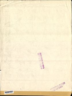
- Description:
- 1939
- Subject:
- Topical Subject: Soviet Union, Geographic Subject: Katino, and Topical Subject: Maps
- Publisher:
- Главное управление геодезии и картографии при СНК СССР
- Language:
- Russian
- Date Created:
- 1941
- Identifier:
- VAC9619-003144
- Genre:
- Military Maps and Topographic Maps
- Geographic Location:
- Coordinates: 53.667, 39, 54, 39.5
- Related URL:
- Catalog URL: https://iucat.iu.edu/catalog/5020129 and Download GeoTIFF: https://drive.google.com/file/d/1aumwkFGP6yJbmUv2UUhqHsRXLeajp_DK/view?usp=sharing
- Abstract:
- Modern area represented: Katino, Russia
- Call Number:
- G7000 s100 .S7 sheet N-37-79
- Caption:
- Секретно
- City:
- Катино (Katino)
- Copyright Holder:
- No Copyright - United States
- Country:
- СССР (USSR)
- State/Province:
- Чапаевский район (Chapayevsky district), Чернавский район (Chernavsky district), Милославский район (Miloslavsky district), Пронский район (Pronsky district)...
- Physical Description:
- Scale: 1:100,000
- Persistent URL:
- http://purl.dlib.indiana.edu/iudl/images/VAC9619/VAC9619-003144
- Provenance:
- Army Map Service Library, Library of Congress G & M Division
-
- Description:
- 1940
- Subject:
- Topical Subject: Soviet Union, Topical Subject: Maps, and Geographic Subject: Kosterevo
- Publisher:
- Генеральный штаб Красной Армии
- Language:
- Russian
- Date Created:
- 1941
- Identifier:
- VAC9619-003145
- Genre:
- Military Maps and Topographic Maps
- Geographic Location:
- Coordinates: 55.667, 39.5, 56, 40
- Related URL:
- Download GeoTIFF: https://drive.google.com/file/d/1lXpt435Ace79w-uhu6oJaImsJHOM7lch/view?usp=sharing and Catalog URL: https://iucat.iu.edu/catalog/5020129
- Abstract:
- Modern area represented: Костерево (Kosterevo), Vladimirskaya oblast, Russia
- Call Number:
- G7000 s100 .S7 sheet N-37-8
- Caption:
- Captured map
- City:
- Костерево (Kosterevo)
- Copyright Holder:
- No Copyright - United States
- Country:
- СССР (USSR)
- State/Province:
- Ивановская область (Ivanovo oblast), Московская область (Moscow oblast), and РСФСР (RSFSR)
- Physical Description:
- Scale: 1:100,000
- Persistent URL:
- http://purl.dlib.indiana.edu/iudl/images/VAC9619/VAC9619-003145
- Provenance:
- DMA Topographic Center, Army Map Service Library, OMAHA, Library of Congress Geography & Map Division
-
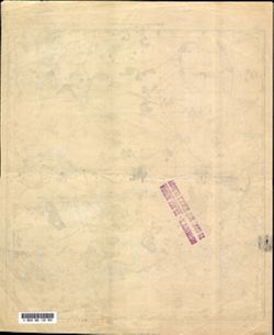
- Description:
- 1939
- Subject:
- Topical Subject: Soviet Union, Topical Subject: Maps, and Geographic Subject: Skopin
- Publisher:
- Генеральный штаб Красной Армии
- Language:
- Russian
- Date Created:
- 1941
- Identifier:
- VAC9619-003146
- Genre:
- Topographic Maps and Military Maps
- Geographic Location:
- Coordinates: 53.667, 39.5, 54, 40
- Related URL:
- Download GeoTIFF: https://drive.google.com/file/d/1Zi7-5zL9N8MCtfbAZocjTyH05coa9ax5/view?usp=sharing and Catalog URL: https://iucat.iu.edu/catalog/5020129
- Abstract:
- Modern area represented: Skopin, Ryazan oblast, Russia
- Call Number:
- G7000 s100 .S7 sheet N-37-80
- Caption:
- Для служебного пользования
- City:
- Скопин (Skopin)
- Copyright Holder:
- No Copyright - United States
- Country:
- СССР (USSR)
- State/Province:
- Рязанская область (Ryazan oblast) and РСФСР (RSFSR)
- Physical Description:
- Scale: 1:100,000
- Persistent URL:
- http://purl.dlib.indiana.edu/iudl/images/VAC9619/VAC9619-003146
- Provenance:
- Army Map Service Library, Library of Congress G & M Division
-
- Subject:
- Topical Subject: Soviet Union, Topical Subject: Maps, and Geographic Subject: Bolkhov
- Publisher:
- Генеральный штаб Красной Армии
- Language:
- Russian
- Date Created:
- 1941
- Identifier:
- VAC9619-003147
- Genre:
- Military Maps and Topographic Maps
- Geographic Location:
- Coordinates: 53.333, 36, 53.667, 36.5
- Related URL:
- Download GeoTIFF: https://drive.google.com/file/d/1w9cDkiZnrRF-N2oxwPMUykuP5Ujr-v6d/view?usp=sharing and Catalog URL: https://iucat.iu.edu/catalog/5020129
- Abstract:
- Modern area represented: Bolkhov, Russia
- Call Number:
- G7000 s100 .S7 sheet N-37-85
- City:
- Болхов (Bolkhov)
- Copyright Holder:
- No Copyright - United States
- Country:
- СССР (USSR)
- State/Province:
- Орловская область (Oryol oblast) and Тульская область (Tula oblast)
- Physical Description:
- Scale: 1:100,000
- Persistent URL:
- http://purl.dlib.indiana.edu/iudl/images/VAC9619/VAC9619-003147
- Provenance:
- Army Map Service Library, Library of Congress G & M Division
-
- Description:
- 1937
- Subject:
- Topical Subject: Soviet Union, Topical Subject: Maps, and Geographic Subject: Chern
- Publisher:
- Главное управление геодезии и картографии при СНК СССР
- Language:
- Russian
- Date Created:
- 1941
- Identifier:
- VAC9619-003148
- Genre:
- Topographic Maps and Military Maps
- Geographic Location:
- Coordinates: 53.333, 36.5, 53.667, 37
- Related URL:
- Download GeoTIFF: https://drive.google.com/file/d/1460asdYGdiJ2Xk_G0_x-dkwTk630hzUu/view?usp=sharing and Catalog URL: https://iucat.iu.edu/catalog/5020129
- Abstract:
- Modern area represented: Chern, Russia
- Call Number:
- G7000 s100 .S7 sheet N-37-86
- City:
- Чернь (Chern)
- Copyright Holder:
- No Copyright - United States
- Country:
- СССР (USSR)
- State/Province:
- РСФСР (RSFSR), Орловская область (Oryol oblast), and Тульская область (Tula oblast)
- Physical Description:
- Scale: 1:100,000
- Persistent URL:
- http://purl.dlib.indiana.edu/iudl/images/VAC9619/VAC9619-003148
- Provenance:
- DMA Topographic Center, Army Map Service Library, Auswärtiges Amt. Geographischer Dienst
