
Search Constraints
You searched for:
Date Created
1970
Remove constraint Date Created: 1970
Holding Location
B-WELLS
Remove constraint Holding Location: B-WELLS
Search Results
-
- Subject:
- Topical Subject: Coal mines and mining and Geographic Subject: Indiana
- Creator:
- Hutchison, Harold C. (Harold Christy), 1925-
- Publisher:
- Indiana. Geological Survey
- Date Created:
- 1970
- Identifier:
- VAC3073-M-00965
- Genre:
- Mine maps
- Geographic Location:
- Coordinates: W0880150 W0862422 N0403746 N0374559
- Related URL:
- Catalog URL: https://iucat.iu.edu/catalog/5046399
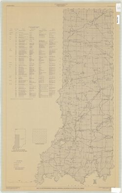
- Abstract:
- Blue line print. "Base modified from Indiana Department of Conservation, Geological Survey. Base map of portion of western Indiana, 1951." Includ...
- Call Number:
- G4091 .H9 1970 .H8
- Caption:
- Imprint: [Bloomington, Ind.] : Indiana Dept. of Conservation, Geological Survey, [1970]
- Physical Description:
- Dimensions: 88 x 54 cm and Scale: 1:325,000
- Alternate Identifier:
- Title Control Number: a5046399
- Persistent URL:
- https://purl.dlib.indiana.edu/iudl/images/VAC3073/VAC3073-M-00965
-
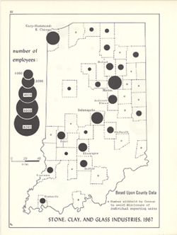
- Subject:
- Geographic Subject: Indiana, Topical Subject: Stone industry and trade, Topical Subject: Labor supply, and Topical Subject: Ceramic industries
- Creator:
- Kingsbury, Robert C. and Hollingsworth, John M.
- Publisher:
- Indiana University, Bloomington. Department of Geography
- Date Created:
- 1970
- Identifier:
- VAC3073-M-00936
- Genre:
- Thematic maps and Statistical maps
- Geographic Location:
- Coordinates: W0880700 W0844500 N0414500 N0374600
- Related URL:
- Catalog URL: https://iucat.iu.edu/catalog/18454460
- Abstract:
- Choropleth map with graduated circles showing the number of employees in each county employed by mineral processing industries in 1967. Detached from: An ...
- Call Number:
- G4091.G8 1967 .K53
- Caption:
- Imprint: [Bloomington, Indiana] : [Department of Geography, Indiana University], [1970]
- Physical Description:
- Scale: Approximately 1:1,950,000 and Dimensions: 26 x 18 cm, on sheet 28 x 21 cm
- Alternate Identifier:
- Alternate ID: 317383IP and Title Control Number: a18454460
- Persistent URL:
- https://purl.dlib.indiana.edu/iudl/images/VAC3073/VAC3073-M-00936
- Provenance:
- An atlas of Indiana / by Robert C. Kingsbury [1970].
-
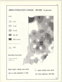
- Subject:
- Topical Subject: Population geography, Topical Subject: Historical geography, Topical Subject: SYMAP (Computer program language), Geographic Subject: Indiana...
- Creator:
- Hollingsworth, John M., Indiana University. Research Computing Center, and Kingsbury, Robert C.
- Publisher:
- Indiana University. Department of Geography
- Date Created:
- 1970
- Identifier:
- VAC3073-M-00926
- Genre:
- Thematic maps
- Geographic Location:
- Coordinates: W0880700 W0844500 N0414500 N0374600
- Related URL:
- Catalog URL: https://iucat.iu.edu/catalog/15948261
- Abstract:
- Computer generated isopleth map obtained through use of the facilities of Indiana University's Research Computer Center. ASCII-art map created using SYMA...
- Call Number:
- G4091.E2 1960 .K52
- Caption:
- Imprint: Bloomington, Indiana : Department of Geography, Indiana University, [1970]
- Physical Description:
- Dimensions: 26 x 18 cm, on sheet 28 x 21 cm and Scale: Approximately 1:2,500,000
- Alternate Identifier:
- Alternate ID: 317383IP and Title Control Number: a15948261
- Persistent URL:
- https://purl.dlib.indiana.edu/iudl/images/VAC3073/VAC3073-M-00926
- Provenance:
- An atlas of Indiana / by Robert C. Kingsbury [1970].
-
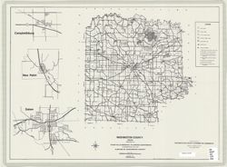
- Subject:
- Geographic Subject: Washington County (Ind.)
- Creator:
- River Hills Regional Planning Commission
- Publisher:
- River Hills Regional Planning Commission
- Date Created:
- 1970
- Identifier:
- VAC3073-M-00921
- Genre:
- Maps
- Geographic Location:
- Coordinates: W0861836 W0855051 N0384700 N0382504
- Related URL:
- Catalog URL: https://iucat.iu.edu/catalog/1342078
- Abstract:
- Includes insets of Campbellsburg, New Pekin , Salem areas.
- Call Number:
- G4093.W5 1970 .R58
- Caption:
- Imprint: Salem, Ind. : River Hills Regional Planning Commission, [197-?]
- Physical Description:
- Scale: 1:126,720 & 1:5,280 and Dimensions: 43 x 59 cm
- Alternate Identifier:
- Title Control Number: ALJ1413BB
- Persistent URL:
- https://purl.dlib.indiana.edu/iudl/images/VAC3073/VAC3073-M-00921
-
- Subject:
- Geographic Subject: Indiana and Topical Subject: Phytogeography
- Creator:
- Hollingsworth, John M. and Kingsbury, Robert C.
- Publisher:
- Indiana University. Department of Geography
- Date Created:
- 1970
- Identifier:
- VAC3073-M-00916
- Genre:
- Thematic maps
- Geographic Location:
- Coordinates: W0880700 W0844500 N0414500 N0374600
- Related URL:
- Catalog URL: https://iucat.iu.edu/catalog/15941617
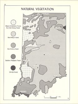
- Abstract:
- Shows bluestem prairie, oak-hickory forest, beech and maple forest, southern floodplain forest, and elm-ash forest. Detached from: An atlas of Indiana / b...
- Call Number:
- G4091.D2 1970 .K56
- Caption:
- Imprint: Bloomington, Indiana : Department of Geography, Indiana University, [1970
- Physical Description:
- Scale: Approximately 1:1,950,000 and Dimensions: 26 x 18 cm, on sheet 28 x 21 cm
- Alternate Identifier:
- Alternate ID: 317383IP and Title Control Number: a15941617
- Persistent URL:
- https://purl.dlib.indiana.edu/iudl/images/VAC3073/VAC3073-M-00916
- Provenance:
- An atlas of Indiana / by Robert C. Kingsbury [1970].
-
- Subject:
- Topical Subject: Physical geography, Geographic Subject: Indiana, Topical Subject: Glacial landforms, and Topical Subject: Physiographic provinces
- Creator:
- Hollingsworth, John M. and Kingsbury, Robert C.
- Publisher:
- Indiana University. Department of Geography
- Date Created:
- 1970
- Identifier:
- VAC3073-M-00917
- Genre:
- Geological maps and Physical maps
- Geographic Location:
- Coordinates: W0880700 W0844500 N0414500 N0374600
- Related URL:
- Catalog URL: https://iucat.iu.edu/catalog/15938768
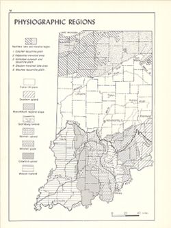
- Abstract:
- Also shows Wisconsin glacial boundary and Illinoian glacial boundary. Detached from: An atlas of Indiana / by Robert C. Kingsbury , with contributions fro...
- Call Number:
- G4091.C21 1970 .K56
- Caption:
- Imprint: Bloomington, Indiana : Department of Geography, Indiana University, [1970]
- Physical Description:
- Dimensions: 26 x 18 cm, on sheet 28 x 21 cm and Scale: Approximately 1:2,000,000
- Alternate Identifier:
- Alternate ID: 317383IP and Title Control Number: a15938768
- Persistent URL:
- https://purl.dlib.indiana.edu/iudl/images/VAC3073/VAC3073-M-00917
- Provenance:
- An atlas of Indiana / by Robert C. Kingsbury [1970].
-
- Subject:
- Geographic Subject: Indiana and Topical Subject: Electric railroads
- Creator:
- Hollingsworth, John M. and Kingsbury, Robert C.
- Publisher:
- Indiana University. Department of Geography
- Date Created:
- 1970
- Identifier:
- VAC3073-M-00908
- Genre:
- Thematic maps
- Geographic Location:
- Coordinates: W0880700 W0844500 N0414500 N0374600
- Related URL:
- Catalog URL: https://iucat.iu.edu/catalog/15934645
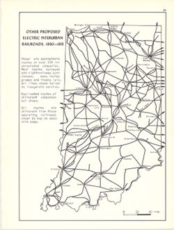
- Abstract:
- Shows approximate routes of over 250 incorporated companies. Detached from: An atlas of Indiana / by Robert C. Kingsbury , with contributions from John M...
- Call Number:
- G4091.P3 1915 .K57
- Caption:
- Imprint: Bloomington, Indiana : Department of Geography, Indiana University, [1970]
- Physical Description:
- Dimensions: 26 x 18 cm, on sheet 28 x 21 cm and Scale: Approximately 1:1,950,000
- Alternate Identifier:
- Alternate ID: 317383IP and Title Control Number: a15934645
- Persistent URL:
- https://purl.dlib.indiana.edu/iudl/images/VAC3073/VAC3073-M-00908
- Provenance:
- An atlas of Indiana / by Robert C. Kingsbury [1970].
-
- Subject:
- Topical Subject: Traffic flow, Topical Subject: Airways, Geographic Subject: Indiana, and Topical Subject: Air travel
- Creator:
- Kingsbury, Robert C. and Hollingsworth, John M.
- Publisher:
- Indiana University. Department of Geography
- Date Created:
- 1970
- Identifier:
- VAC3073-M-00890
- Genre:
- Thematic maps
- Geographic Location:
- Coordinates: W0880700 W0844500 N0414500 N0374600
- Related URL:
- Catalog URL: https://iucat.iu.edu/catalog/15938111
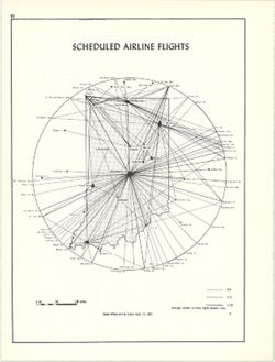
- Abstract:
- Shows average number of flights daily between cities. Data source: Official airline guide, Sept. 15, 1969. Detached from: An atlas of Indiana / by Robert ...
- Call Number:
- G4091.P6 1969 .K56
- Caption:
- Imprint: Bloomington, Indiana : Department of Geography, Indiana University, [1970]
- Physical Description:
- Scale: Approximately 1:5,200,000 and Dimensions: 26 x 18 cm, on sheet 28 x 21 cm
- Alternate Identifier:
- Title Control Number: a15938111 and Alternate ID: 317383IP
- Persistent URL:
- https://purl.dlib.indiana.edu/iudl/images/VAC3073/VAC3073-M-00890
- Provenance:
- An atlas of Indiana / by Robert C. Kingsbury [1970].
-
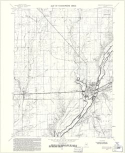
- Subject:
- Topical Subject: Flood forecasting, Geographic Subject: Knightstown Region (Ind.), Topical Subject: Floodplains, Geographic Subject: Henry County (Ind.), Geo...
- Creator:
- Geological Survey (U.S.)
- Publisher:
- Geological Survey (U.S.)
- Date Created:
- 1970
- Identifier:
- VAC3073-M-00888
- Genre:
- Topographic maps, 7.5 minute topographic maps, and Quadrangle maps
- Geographic Location:
- Coordinates: W0853730 W0853000 N0395230 N0394500
- Related URL:
- Catalog URL: https://iucat.iu.edu/catalog/18416327
- Abstract:
- Filing title: Knightstown, Ind. Relief shown by contours and spot heights. Contour interval 10 feet. Includes quadrangle location map. Shows portion of Henry...
- Call Number:
- G4091.C32 s24 .G4 Knightstown 1970
- Caption:
- Imprint: Washington, D.C. : Interior--Geological Survey, [1970]
- Physical Description:
- Scale: 1:24,000 and Dimensions: 59 x 45 or smaller
- Alternate Identifier:
- Alternate ID: CAW5372BB and Title Control Number: a18416327
- Persistent URL:
- https://purl.dlib.indiana.edu/iudl/images/VAC3073/VAC3073-M-00888
- Provenance:
- United States Department of the Interior, Geological Survey. Map of flood-prone areas : [Indiana]. Washington, D.C. : The Survey, 1969-.
-
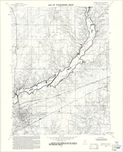
- Subject:
- Geographic Subject: Greencastle (Ind.), Topical Subject: Flood forecasting, Geographic Subject: Putnam County (Ind.), Topical Subject: Floodplains, and Topic...
- Creator:
- Geological Survey (U.S.)
- Publisher:
- Geological Survey (U.S.)
- Date Created:
- 1970
- Identifier:
- VAC3073-M-00867
- Genre:
- 7.5 minute topographic maps, Quadrangle maps, and Topographic maps
- Geographic Location:
- Coordinates: W0865230 W0864500 N0394500 N0393730
- Related URL:
- Catalog URL: https://iucat.iu.edu/catalog/18416317
- Abstract:
- Polyconic projection. Relief shown by contours and spot heights. 7.5 U.S. topographic map with flood-prone areas designated north and northeast of Greencastl...
- Call Number:
- G4091.C32 s24 .G4 Greencastle 1970
- Caption:
- Imprint: Washington, D.C. : United States, Department of the Interior, Geological Survey, 1970.
- Physical Description:
- Dimensions: 58 x 45 cm and Scale: 1:24,000
- Alternate Identifier:
- Title Control Number: a18416317 and Alternate ID: CAW5372BB
- Persistent URL:
- https://purl.dlib.indiana.edu/iudl/images/VAC3073/VAC3073-M-00867
- Provenance:
- United States Department of the Interior, Geological Survey. Map of flood-prone areas : [Indiana]. Washington, D.C. : The Survey, 1969-.
