
Search Constraints
You searched for:
Collections
Russian Military Topographic Map Collection
Remove constraint Collections: Russian Military Topographic Map Collection
Publisher
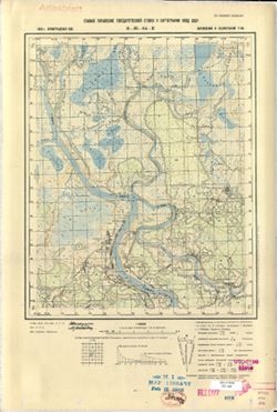
Главное управление государственной съемки и картографии НКВД СССР
Remove constraint Publisher: Главное управление государственной съемки и картографии НКВД СССР
« Previous |
1 - 10 of 75
|
Next »
Search Results
-
- Description:
- 1937
- Subject:
- Topical Subject: Soviet Union, Geographic Subject: Babino, and Topical Subject: Maps
- Publisher:
- Главное управление государственной съемки и картографии НКВД СССР
- Language:
- Russian
- Date Created:
- 1941
- Identifier:
- VAC9619-000044
- Genre:
- Military Maps and Topographic Maps
- Geographic Location:
- Coordinates: 59.1667, 31.25, 59.3333, 31.5
- Related URL:
- Download GeoTIFF: https://drive.google.com/open?id=117pSSxlZhQGDjutRAtCtoaIqVDkp3Xa0 and Catalog URL: http://iucat.iu.edu/catalog/5020131
- Abstract:
- Modern area represented:
- Call Number:
- G7000 s50 .S68 sheet O-36-27-B
- Caption:
- Секретно,Captured map
- City:
- Бабино (Babino)
- Copyright Holder:
- No Copyright - United States
- Country:
- СССР (USSR)
- State/Province:
- Тосненский район (Tosnensky district), РСФСР (RSFSR), Ленинградская область (Leningrad oblast), and Чудовский район (Chudovsky district)
- Physical Description:
- Scale: 1:50,000
- Persistent URL:
- http://purl.dlib.indiana.edu/iudl/images/VAC9619/VAC9619-000044
- Provenance:
- DMA Topographic Center, Army Map Service Library, OMAHA, Library of Congress Geography & Map Division
-
- Description:
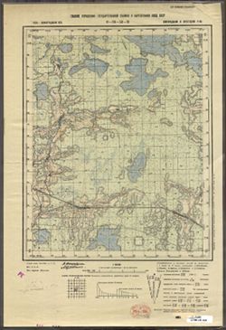
- 1937
- Subject:
- Topical Subject: Soviet Union, Geographic Subject: Korkino, and Topical Subject: Maps
- Publisher:
- Главное управление государственной съемки и картографии НКВД СССР
- Language:
- Russian
- Date Created:
- 1941
- Identifier:
- VAC9619-000043
- Genre:
- Topographic Maps and Military Maps
- Geographic Location:
- Coordinates: 59.1667, 31, 59.3333, 31.25
- Related URL:
- Catalog URL: http://iucat.iu.edu/catalog/5020131 and Download GeoTIFF: https://drive.google.com/open?id=1bsTUMvoE0kAKG1XeVu6aZENX9H3qNZIO
- Abstract:
- Modern area represented: Korkino, Russia
- Call Number:
- G7000 s50 .S68 sheet O-36-27-A
- Caption:
- Для служебного пользования
- City:
- Коркино (Korkino)
- Copyright Holder:
- No Copyright - United States
- Country:
- СССР (USSR)
- State/Province:
- РСФСР (RSFSR), Тосненский район (Tosnensky district), and Ленинградская область (Leningrad oblast)
- Physical Description:
- Scale: 1:50,000
- Persistent URL:
- http://purl.dlib.indiana.edu/iudl/images/VAC9619/VAC9619-000043
- Provenance:
- DMA Topographic Center, Army Map Service Library, OMAHA, Library of Congress Geography & Map Division
-
- Description:
- 1937
- Subject:
- Geographic Subject: Kubolovo, Topical Subject: Soviet Union, and Topical Subject: Maps
- Publisher:
- Главное управление государственной съемки и картографии НКВД СССР
- Language:
- Russian
- Date Created:
- 1941
- Identifier:
- VAC9619-000042
- Genre:
- Topographic Maps and Military Maps
- Geographic Location:
- Coordinates: 59, 30.75, 59.1667, 31
- Related URL:
- Download GeoTIFF: https://drive.google.com/open?id=1Zo_O0BWAAl8rG6V8h9VkfMkerMU104rZ and Catalog URL: http://iucat.iu.edu/catalog/5020131
- Abstract:
- Modern area represented: Kubolovo, Russia
- Call Number:
- G7000 s50 .S68 sheet O-36-26-D
- Caption:
- Секретно,Captured map
- City:
- Куболово (Kubolovo)
- Copyright Holder:
- No Copyright - United States
- Country:
- СССР (USSR)
- State/Province:
- Тосненский район (Tosnensky district), Оредежский район (Oredezhsky district), Ленинградская область (Leningrad oblast), Новгородский район (Novgorod distric...
- Physical Description:
- Scale: 1:50,000
- Persistent URL:
- http://purl.dlib.indiana.edu/iudl/images/VAC9619/VAC9619-000042
- Provenance:
- DMA Topographic Center, Army Map Service Library, OMAHA, Library of Congress Geography & Map Division
-
- Description:
- 1937
- Subject:
- Geographic Subject: Nesterkovo, Topical Subject: Maps, and Topical Subject: Soviet Union
- Publisher:
- Главное управление государственной съемки и картографии НКВД СССР
- Language:
- Russian
- Date Created:
- 1941
- Identifier:
- VAC9619-000041
- Genre:
- Topographic Maps and Military Maps
- Geographic Location:
- Coordinates: 59, 30.5, 59.1667, 30.75
- Related URL:
- Catalog URL: http://iucat.iu.edu/catalog/5020131 and Download GeoTIFF: https://drive.google.com/open?id=15zmLpNAtR49LfgQ9suZDHQMWXpE-EEqP
- Abstract:
- Modern area represented: Nesterkovo, Russia
- Call Number:
- G7000 s50 .S68 sheet O-36-26-C
- Caption:
- Секретно,Captured map
- City:
- Нестерково (Nesterkovo)
- Copyright Holder:
- No Copyright - United States
- Country:
- СССР (USSR)
- State/Province:
- РСФСР (RSFSR), Оредежский район (Oredezhsky district), Тосненский район (Tosnensky district), and Ленинградская область (Leningrad oblast)
- Physical Description:
- Scale: 1:50,000
- Persistent URL:
- http://purl.dlib.indiana.edu/iudl/images/VAC9619/VAC9619-000041
- Provenance:
- DMA Topographic Center, Army Map Service Library, OMAHA, Library of Congress Geography & Map Division
-

- Description:
- 1937
- Subject:
- Geographic Subject: Gummolovo and Topical Subject: Soviet Union
- Publisher:
- Главное управление государственной съемки и картографии НКВД СССР
- Language:
- Russian
- Date Created:
- 1941
- Identifier:
- VAC9619-000040
- Genre:
- Military Maps and Topographic Maps
- Geographic Location:
- Coordinates: 59.1667, 30.75, 59.3333, 31
- Related URL:
- Catalog URL: http://iucat.iu.edu/catalog/5020131 and Download GeoTIFF: https://drive.google.com/open?id=1Thglq8S3ntpZfPmHWFNFQ1QHmQpoR5Lu
- Abstract:
- Modern area represented: Gummolovo, Russia
- Call Number:
- G7000 s50 .S68 sheet O-36-26-B
- Caption:
- Для служебного пользования
- City:
- Гуммолово (Gummolovo)
- Copyright Holder:
- No Copyright - United States
- Country:
- СССР (USSR)
- State/Province:
- Ленинградская область (Leningrad oblast), Тосненский район (Tosnensky district), and РСФСР (RSFSR)
- Physical Description:
- Scale: 1:50,000
- Persistent URL:
- http://purl.dlib.indiana.edu/iudl/images/VAC9619/VAC9619-000040
- Provenance:
- Army Map Service Library, OMAHA, Library of Congress Geography & Map Division
-

- Description:
- 1938
- Subject:
- Topical Subject: Maps, Topical Subject: Soviet Union, and Geographic Subject: Nizhniye Sergi
- Publisher:
- Главное управление государственной съемки и картографии НКВД СССР
- Language:
- Russian
- Identifier:
- VAC9619-002300
- Genre:
- Topographic Maps and Military Maps
- Geographic Location:
- Coordinates: 56.3333, 59, 56.6667, 59.5
- Related URL:
- Download GeoTIFF: https://drive.google.com/file/d/1NO9kt2bJTbNiD91eJqzhQEITkT6AmIda/view?usp=sharing and Catalog URL: https://iucat.iu.edu/catalog/5020129
- Abstract:
- Modern area represented: Nizhniye Sergi, Russia
- Call Number:
- G7000 s100 .S7 sheet O-40-131
- City:
- Нижние Серги (Nizhniye Sergi)
- Copyright Holder:
- No Copyright - United States
- Country:
- СССР (USSR)
- State/Province:
- Свердловская область (Sverdlovsk oblast), Артинский район (Artinsky district), Нижнесергинский район (Nizhneserginsky district), Нязепетровский район (Nyazep...
- Physical Description:
- Scale: 1:100,000
- Persistent URL:
- http://purl.dlib.indiana.edu/iudl/images/VAC9619/VAC9619-002300
- Provenance:
- DMA Topographic Center, Army Map Service Library
-
- Description:
- 1938
- Subject:
- Topical Subject: Maps, Geographic Subject: Konakovo, and Topical Subject: Soviet Union
- Publisher:
- Главное управление государственной съемки и картографии НКВД СССР
- Language:
- Russian
- Date Created:
- 1941
- Identifier:
- VAC9619-003522
- Genre:
- Topographic Maps and Military Maps
- Geographic Location:
- Coordinates: 56.667, 36.75, 56.833, 37
- Related URL:
- Download GeoTIFF: https://drive.google.com/file/d/113GolZU0LWI5CWw31Rws39j5ikise7Gi/view?usp=sharing and Catalog URL: http://iucat.iu.edu/catalog/5020131
- Abstract:
- Modern area represented: Конаково (Konakovo), Tverskaya oblast, Russia
- Call Number:
- GM G7000 s50 .S68 sheet O-37-110-D
- City:
- Конаково (Konakovo)
- Copyright Holder:
- No Copyright - United States
- Country:
- СССР (USSR)
- State/Province:
- Калининская область (Kalinin oblast), Оршинский район (Orshinsky district), Конаковский район (Konakovsky district), and Кимрский район (Kimrsky district)
- Physical Description:
- Scale: 1:50,000
- Persistent URL:
- http://purl.dlib.indiana.edu/iudl/images/VAC9619/VAC9619-003522
- Provenance:
- DMA Topographic Center, Army Map Service Library, OMAHA, Library of Congress Geography & Map Division
-
- Description:
- 1938
- Subject:
- Geographic Subject: Vyshitino, Topical Subject: Soviet Union, and Topical Subject: Maps
- Publisher:
- Главное управление государственной съемки и картографии НКВД СССР
- Language:
- Russian
- Identifier:
- VAC9619-003534
- Genre:
- Topographic Maps and Military Maps
- Geographic Location:
- Coordinates: 57.3333, 31.75, 57.5, 32.0
- Related URL:
- Catalog URL: http://iucat.iu.edu/catalog/5020131 and Download GeoTIFF: https://drive.google.com/file/d/15fYzUgb8nygu04vteSGvdZHPizVqeb0h/view?usp=sharing
- Abstract:
- Modern area represented: Вышитино (Vyshitino), Novgorodskaya oblast, Russia
- Call Number:
- GM G7000 s50 .S68 sheet O-36-88-D
- Caption:
- Captured map
- City:
- Вышитино (Vyshitino)
- Copyright Holder:
- No Copyright - United States
- Country:
- СССР (USSR)
- State/Province:
- Ленинградская область (Leningrad oblast), Молвотицкий район (Molvotitsky district), and Залучский район (Zaluchsky district)
- Physical Description:
- Scale: 1:50,000
- Persistent URL:
- http://purl.dlib.indiana.edu/iudl/images/VAC9619/VAC9619-003534
- Provenance:
- DMA Topographic Center, Army Map Service Library, OMAHA, Library of Congress Geography & Map Division
-
- Description:
- 1938
- Subject:
- Geographic Subject: Yur'yevo, Topical Subject: Soviet Union, and Topical Subject: Maps
- Publisher:
- Главное управление государственной съемки и картографии НКВД СССР
- Language:
- Russian
- Identifier:
- VAC9619-002911
- Genre:
- Military Maps and Topographic Maps
- Geographic Location:
- Coordinates: 58, 31.5, 58.167, 31.75
- Related URL:
- Catalog URL: http://iucat.iu.edu/catalog/5020131 and Download GeoTIFF: https://drive.google.com/file/d/1_4MNylz2L__3yRfDgH-rc80b98Suz4MY/view?usp=sharing
- Abstract:
- Modern area represented: Юрьево (Yur'yevo), Novgorodskaya oblast, Russia
- Call Number:
- GM G7000 s50 .S68 sheet O-36-64-С
- Caption:
- Для служебного пользования
- City:
- Юрьево (Yur'yevo)
- Copyright Holder:
- No Copyright - United States
- Country:
- СССР (USSR)
- State/Province:
- Лычковский район (Lychkovsky district), Старорусский район (Starorussky district), and Ленинградская область (Leningrad oblast)
- Physical Description:
- Scale: 1:50,000
- Persistent URL:
- http://purl.dlib.indiana.edu/iudl/images/VAC9619/VAC9619-002911
- Provenance:
- M. I. Map Library, Library of Congress Geography & Map Division
-
- Description:
- 1938
- Subject:
- Topical Subject: Maps, Geographic Subject: Zaytsevo, and Topical Subject: Soviet Union
- Publisher:
- Главное управление государственной съемки и картографии НКВД СССР
- Language:
- Russian
- Identifier:
- VAC9619-003372
- Genre:
- Topographic Maps and Military Maps
- Geographic Location:
- Coordinates: 58.333, 32, 58.5, 32.25
- Related URL:
- Catalog URL: http://iucat.iu.edu/catalog/5020131 and Download GeoTIFF: https://drive.google.com/file/d/1K7qE21hkq2ReYNYXblrWOZeFfyL59Z1D/view?usp=sharing
- Abstract:
- Modern area represented: Дворищи (Dvorishchi), Novgorodskaya oblast, Russia
- Call Number:
- G7000 s50 .S68 sheet O-36-53-C
- Caption:
- Для служебного пользования
- City:
- Зайцево (Zaytsevo)
- Copyright Holder:
- No Copyright - United States
- Country:
- СССР (USSR)
- State/Province:
- Крестецкий район (Krestetsky district), Новгородский район (Novgorod district), and Ленинградская область (Leningrad oblast)
- Physical Description:
- Scale: 1:50,000
- Persistent URL:
- http://purl.dlib.indiana.edu/iudl/images/VAC9619/VAC9619-003372
- Provenance:
- Army Map Service Library, OMAHA, Library of Congress Geography & Map Division
