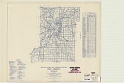
Geographic Subject: Fayette County (Ind.) and Topical Subject: Roads
Creator:
Indiana. State Highway Commission (1919-1953)
Publisher:
State Highway Commission of Indiana
Date Created:
1949
Identifier:
VAC3073-M-00960
Genre:
Road maps
Geographic Location:
Coordinates: W0851800 W0850200 N0394700 N0393200
Related URL:
Catalog URL: https://iucat.iu.edu/catalog/5704581
Abstract:
Blueline. "State roads revised to January 1, 1949." "Data obtained from State-wide Highway Planning Survey." Includes chart "Culture...
Call Number:
G4093.F3P2 1949 .I53
Caption:
Imprint: [Indianapolis?] : State Highway Commission of Indiana. 1949.
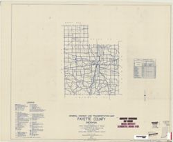
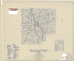
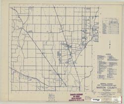
Topical Subject: Roads and Geographic Subject: Bartholomew County (Ind.)
Creator:
Indiana. State Highway Commission (1919-1953)
Publisher:
Indiana. State Highway Commission (1919-1953)
Date Created:
1949
Identifier:
VAC3073-M-00950
Genre:
Road maps
Geographic Location:
Coordinates: W0860500 W0844100 N0392100 N0390200
Related URL:
Catalog URL: https://iucat.iu.edu/catalog/5359878
Abstract:
Blue line print. "State roads revised January 1, 1949." "1937." "Data obtained from State-wide Highway Planning Survey." "...
Call Number:
G4093.B3P2 1949 .I53
Caption:
Imprint: [Indianapolis?] : State Highway Commission of Indiana, 1949.
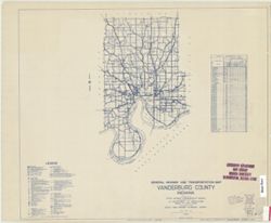
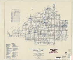
Geographic Subject: Gibson County (Ind.) and Topical Subject: Roads
Creator:
Indiana. State Highway Commission (1919-1953)
Publisher:
Indiana. State Highway Commission (1961-1981)
Date Created:
1949
Identifier:
VAC3073-M-00935
Genre:
Road maps
Geographic Location:
Coordinates: W0875900 W0871900 N0383200 N0381000
Related URL:
Catalog URL: https://iucat.iu.edu/catalog/5705940
Abstract:
Blueline. "State roads revised to January 1, 1949." "1937." "Data obtained from Statewide Highway Planning Survey." Includes lo...
Call Number:
G4093.G5P2 1949 .I53
Caption:
Imprint: [Indianapolis?] : State Highway Commission of Indiana, 1949.
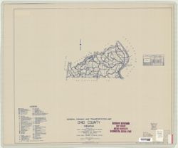
Topical Subject: Roads and Geographic Subject: Ohio County (Ind.)
Creator:
Indiana. State Highway Commission (1919-1953)
Publisher:
State Highway Commission of Indiana
Date Created:
1949
Identifier:
VAC3073-M-00928
Genre:
Road maps
Geographic Location:
Coordinates: W0850800 W0845000 N0390200 N0385400
Related URL:
Catalog URL: https://iucat.iu.edu/catalog/5708035
Abstract:
Blueline. "State roads revised to January 1, 1949." "1927." "Data obtained from State-wide Highway Planning Survey." Includes ...
Call Number:
G4093.O3 P2 1949 .I53
Caption:
Imprint: [Indianapolis?] : State Highway Commission of Indiana, 1949.
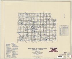
Topical Subject: Roads and Geographic Subject: Marshall County (Ind.)
Creator:
Indiana. State Highway Commission (1919-1953)
Publisher:
State Highway Commission of Indiana
Date Created:
1949
Identifier:
VAC3073-M-00910
Genre:
Road maps
Geographic Location:
Coordinates: W0862800 W0860300 N0412900 N0411000
Related URL:
Catalog URL: https://iucat.iu.edu/catalog/5706696
Abstract:
Blueline. "State roads revised to January 1, 1949." "1937." "Data obtained from State-wide Highway Planning Survey." Includes l...
Call Number:
G4093.M4 P2 1949 .I53
Caption:
Imprint: [Indianapolis?] : State Highway Commission of Indiana, 1949.
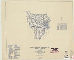
Geographic Subject: Floyd County (Ind.) and Topical Subject: Roads
Creator:
Indiana. State Highway Commission (1919-1953)
Publisher:
State Highway Commission of Indiana
Date Created:
1949
Identifier:
VAC3073-M-00907
Genre:
Road maps
Geographic Location:
Coordinates: W0860200 W0854600 N0382500 N0381100
Related URL:
Catalog URL: https://iucat.iu.edu/catalog/5705891
Abstract:
Blueline. "State road revised to January 1, 1949." "Data obtained from Statewide Highway Planning Survey." Includes chart "Culture i...
Call Number:
G4093.F5P2 1949 .I53
Caption:
Imprint: [Indianapolis?] : State Highway Commission of Indiana, [1949?]