
Search Constraints
You searched for:
Publisher
Управление военных топографов РККА
Remove constraint Publisher: Управление военных топографов РККА
Search Results
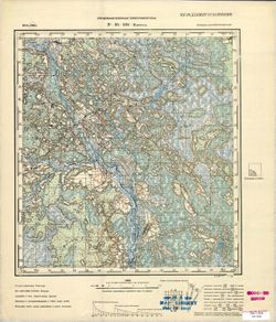
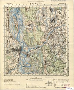
-
- Description:
- 1926
- Subject:
- Geographic Subject: Bogolyubovo, Topical Subject: Maps, and Topical Subject: Soviet Union
- Publisher:
- Управление военных топографов РККА
- Language:
- Russian
- Date Created:
- 1936
- Identifier:
- VAC9619-002277
- Genre:
- Military Maps and Topographic Maps
- Geographic Location:
- Coordinates: 56, 40.5, 56.3333, 41
- Related URL:
- Catalog URL: https://iucat.iu.edu/catalog/5020129 and Download GeoTIFF: https://drive.google.com/file/d/1SHfpY_bvxn3mGrdoWhgp-cce8fDpxMR3/view?usp=sharing
- Abstract:
- Modern area represented: Bogolyubovo, Russia
- Call Number:
- G7000 s100 .S7 sheet O-37-142
- City:
- Боголюбово (Bogolyubovo)
- Copyright Holder:
- No Copyright - United States
- Country:
- СССР (USSR)
- State/Province:
- РСФСР (RSFSR) and Ивановская область (Ivanovo oblast)
- Physical Description:
- Scale: 1:100,000
- Persistent URL:
- http://purl.dlib.indiana.edu/iudl/images/VAC9619/VAC9619-002277
- Provenance:
- DMA Topographic Center, Army Map Service Library, OMAHA, Library of Congress Geography & Map Division
-
- Description:
- 1930
- Subject:
- Topical Subject: Soviet Union, Topical Subject: Maps, and Geographic Subject: Svietlahorsk
- Publisher:
- Управление военных топографов РККА
- Language:
- Russian
- Date Created:
- 1936
- Identifier:
- VAC9619-004134
- Genre:
- Military Maps and Topographic Maps
- Geographic Location:
- Coordinates: 52.333, 29, 52.667, 29.5
- Related URL:
- Catalog URL: https://iucat.iu.edu/catalog/5020129 and Download GeoTIFF: https://drive.google.com/file/d/13N9FLAybZ2nTicCtbfNbknHBgnbTbOlh/view?usp=sharing
- Abstract:
- Modern area represented: Svietlahorsk, Homyel oblast, Belarus
- Call Number:
- G7000 s100 .S7 sheet N-35-132
- Caption:
- Не подлежит оглашению
- City:
- Шацилки (Shatsilki)
- Copyright Holder:
- No Copyright - United States
- Country:
- СССР (USSR)
- State/Province:
- Белорусская ССР (Byelorussian Soviet Socialist Republic)
- Physical Description:
- Scale: 1:100,000
- Persistent URL:
- http://purl.dlib.indiana.edu/iudl/images/VAC9619/VAC9619-004134
- Provenance:
- DMA Topographic Center, Auswärtiges Amt. Geographischer Dienst, OMAHA, Army Map Service Library
-
- Description:
- 1895
- Subject:
- Topical Subject: Maps, Geographic Subject: Slantsy, and Topical Subject: Soviet Union
- Publisher:
- Управление военных топографов РККА
- Language:
- Russian
- Date Created:
- 1936
- Identifier:
- VAC9619-001847
- Genre:
- Topographic Maps and Military Maps
- Geographic Location:
- Coordinates: 59, 28, 59.167, 28.25
- Related URL:
- Download GeoTIFF: https://drive.google.com/open?id=1azu8TWhYFhia79bTs1F23ijf90sJxa8j and Catalog URL: http://iucat.iu.edu/catalog/5020131
- Abstract:
- Modern area represented: Slantsy, Russia
- Call Number:
- G7000 s50 .S68 sheet O-35-33-C
- Caption:
- Не подлежит оглашению,Captured map
- City:
- Сланцы (Slantsy)
- Copyright Holder:
- No Copyright - United States
- Country:
- СССР (USSR) and Эстония (Estonia)
- State/Province:
- Ленинградская область (Leningrad oblast) and РСФСР (RSFSR)
- Physical Description:
- Scale: 1:50,000
- Persistent URL:
- http://purl.dlib.indiana.edu/iudl/images/VAC9619/VAC9619-001847
- Provenance:
- Army Map Service Library, OMAHA, Library of Congress Geography & Map Division
-
- Description:
- 1916
- Subject:
- Geographic Subject: Морач (Morach), Topical Subject: Maps, and Topical Subject: Soviet Union
- Publisher:
- Управление военных топографов РККА
- Language:
- Russian
- Date Created:
- 1936
- Identifier:
- VAC9619-000761
- Genre:
- Topographic Maps and Military Maps
- Geographic Location:
- Coordinates: 52.5, 27.5, 52.667, 27.75
- Related URL:
- Catalog URL: http://iucat.iu.edu/catalog/5020131 and Download GeoTIFF: https://drive.google.com/open?id=1LAByuRyxfjwxyNO78bXbh7EmFF3pEsxW
- Abstract:
- Modern area represented: Морач (Morach), Minsk oblast, Belarus
- Call Number:
- G7000 s50 .s68 sheet N-35-128-A
- Caption:
- Не подлежит оглашению
- City:
- Морочь (Moroch')
- Copyright Holder:
- No Copyright - United States
- Country:
- СССР (USSR) and Польша (Poland)
- State/Province:
- Белорусская ССР (Byelorussian Soviet Socialist Republic)
- Physical Description:
- Scale: 1:50,000
- Persistent URL:
- http://purl.dlib.indiana.edu/iudl/images/VAC9619/VAC9619-000761
- Provenance:
- M. I. Map Library
-
- Description:
- 1931
- Subject:
- Geographic Subject: Zhlobin, Topical Subject: Soviet Union, and Topical Subject: Maps
- Publisher:
- Управление военных топографов РККА
- Language:
- Russian
- Date Created:
- 1936
- Identifier:
- VAC9619-001523
- Genre:
- Topographic Maps and Military Maps
- Geographic Location:
- Coordinates: 52.8667, 30, 53, 30.25
- Related URL:
- Download GeoTIFF: https://drive.google.com/open?id=1fegM38JGNEzEvDxv5geRA4ZAE-L4Nox_ and Catalog URL: http://iucat.iu.edu/catalog/5020131
- Abstract:
- Modern area represented: Zhlobin, Homyel oblast, Belarus
- Call Number:
- G7000 s50 .S68 sheet N-36-109-A
- Caption:
- Не подлежит оглашению
- City:
- Жлобин (Zhlobin)
- Copyright Holder:
- No Copyright - United States
- Country:
- СССР (USSR)
- State/Province:
- Белорусская ССР (Byelorussian Soviet Socialist Republic)
- Physical Description:
- Scale: 1:50,000
- Persistent URL:
- http://purl.dlib.indiana.edu/iudl/images/VAC9619/VAC9619-001523
- Provenance:
- CIA Map Branch -- Received
-

- Description:
- 1926
- Subject:
- Geographic Subject: Gorval, Topical Subject: Maps, and Topical Subject: Soviet Union
- Publisher:
- Управление военных топографов РККА
- Language:
- Russian
- Date Created:
- 1936
- Identifier:
- VAC9619-001547
- Genre:
- Military Maps and Topographic Maps
- Geographic Location:
- Coordinates: 52.5, 30, 52.6667, 30.25
- Related URL:
- Download GeoTIFF: https://drive.google.com/open?id=1SBp1cSyxbsOZzW87Z5z7xzVDLRHTxnom and Catalog URL: http://iucat.iu.edu/catalog/5020131
- Abstract:
- Modern area represented: Gorval, Homyel oblast, Belarus
- Call Number:
- G7000 s50 .S68 sheet N-36-121-A
- Caption:
- Не подлежит оглашению
- City:
- Горваль (Gorval)
- Copyright Holder:
- No Copyright - United States
- Country:
- СССР (USSR)
- State/Province:
- Белорусская ССР (Byelorussian Soviet Socialist Republic)
- Physical Description:
- Scale: 1:50,000
- Persistent URL:
- http://purl.dlib.indiana.edu/iudl/images/VAC9619/VAC9619-001547
- Provenance:
- Army Map Service Library, Library of Congress Geography & Map Division, OMAHA
-
- Description:
- 1931
- Subject:
- Topical Subject: Maps, Geographic Subject: Mingrelskaya, and Topical Subject: Soviet Union
- Publisher:
- Управление военных топографов РККА
- Language:
- Russian
- Date Created:
- 1935
- Identifier:
- VAC9619-000137
- Genre:
- Military Maps and Topographic Maps
- Geographic Location:
- Coordinates: 45, 38.25, 45.167, 38.5
- Related URL:
- Catalog URL: http://iucat.iu.edu/catalog/5020131 and Download GeoTIFF: https://drive.google.com/open?id=1bLzhcgUh8GhgTJT4RxBKFm6tUA0f-6nQ
- Abstract:
- Modern area represented: Mingrelskaya, Krasnodarskiy kray, Russia
- Call Number:
- G7000 s50 .S68 and zsheet L-37-101-D
- Caption:
- Не подлежит оглашению
- City:
- Мингрельская (Mingrelskaya)
- Copyright Holder:
- No Copyright - United States
- Country:
- СССР (USSR)
- State/Province:
- Азово-Черноморский край (Azov-Black Sea kray) and РСФСР (RSFSR)
- Physical Description:
- Scale: 1:50,000
- Persistent URL:
- http://purl.dlib.indiana.edu/iudl/images/VAC9619/VAC9619-000137
- Provenance:
- DMA Topographic Center, Army Map Service Library, OMAHA, Library of Congress Geography & Map Division
-
- Description:
- 1913
- Subject:
- Topical Subject: Maps, Topical Subject: Soviet Union, and Geographic Subject: Partizansk
- Publisher:
- Управление военных топографов РККА
- Language:
- Russian
- Date Created:
- 1934
- Identifier:
- VAC9619-000811
- Genre:
- Topographic Maps and Military Maps
- Geographic Location:
- Coordinates: 43, 133, 43.3333, 133.5
- Related URL:
- Catalog URL: https://iucat.iu.edu/catalog/5020129 and Download GeoTIFF: https://drive.google.com/open?id=1R7GQuqPSC31N6DmuMyrjjbi0qENHsXFB
- Abstract:
- Modern area represented: Partizansk, Primorskiy (Maritime) kray, Russia
- Call Number:
- G7000 s100 .S7 sheet K-53-27
- Caption:
- Не подлежит оглашению
- City:
- Сучан (Suchan)
- Copyright Holder:
- No Copyright - United States
- Country:
- СССР (USSR)
- State/Province:
- РСФСР (RSFSR) and Дальневосточный край (Far Eastern kray)
- Physical Description:
- Scale: 1:100,000
- Persistent URL:
- http://purl.dlib.indiana.edu/iudl/images/VAC9619/VAC9619-000811
- Provenance:
- DMA Topographic Center, Army Map Service Library, Library of Congress Geography & Map Division, Atlasblatt
-
- Description:
- 1908
- Subject:
- Geographic Subject: Ivenets, Topical Subject: Maps, and Topical Subject: Soviet Union
- Publisher:
- Управление военных топографов РККА
- Language:
- Russian
- Date Created:
- 1933
- Identifier:
- VAC9619-004078
- Genre:
- Topographic Maps and Military Maps
- Geographic Location:
- Coordinates: 53.667, 26.5, 54, 27
- Related URL:
- Catalog URL: https://iucat.iu.edu/catalog/5020129 and Download GeoTIFF: https://drive.google.com/file/d/17IBW-4Qy8vDRjL3XAe46WFA6YEoc1hsn/view?usp=sharing
- Abstract:
- Modern area represented: Ivenets, Belarus
- Call Number:
- G7000 s100 .S7 sheet N-35-78
- Caption:
- Не подлежит оглашению
- City:
- Ивенец (Ivenets)
- Copyright Holder:
- No Copyright - United States
- Country:
- Польша (Poland) and СССР (USSR)
- State/Province:
- Белорусская ССР (Byelorussian Soviet Socialist Republic)
- Physical Description:
- Scale: 1:100,000
- Persistent URL:
- http://purl.dlib.indiana.edu/iudl/images/VAC9619/VAC9619-004078
- Provenance:
- DMA Topographic Center, Army Map Service Library, OMAHA
-
- Description:
- 1913
- Subject:
- Topical Subject: Maps, Geographic Subject: Korosten, and Topical Subject: Soviet Union
- Publisher:
- Управление военных топографов РККА
- Language:
- Russian
- Date Created:
- 1933
- Identifier:
- VAC9619-003119
- Genre:
- Military Maps and Topographic Maps
- Geographic Location:
- Coordinates: 50.667, 28.5, 51, 29
- Related URL:
- Catalog URL: https://iucat.iu.edu/catalog/5020129 and Download GeoTIFF: https://drive.google.com/file/d/1r4KaIwlzKRcnmPHpmBYXDKSMN0LMEF56/view?usp=sharing
- Abstract:
- Modern area represented: Korosten, Zhytomyr oblast, Ukraine
- Call Number:
- G7000 s100 .S7 sheet M-35-46
- Caption:
- Не подлежит оглашению
- City:
- Коростень (Korosten)
- Copyright Holder:
- No Copyright - United States
- Country:
- СССР (USSR)
- State/Province:
- Украинская ССР (Ukrainian Soviet Socialist Republic) and Киевская область (Kyiv oblast)
- Physical Description:
- Scale: 1:100,000
- Persistent URL:
- http://purl.dlib.indiana.edu/iudl/images/VAC9619/VAC9619-003119
- Provenance:
- DMA Topographic Center, Army Map Service Library, OMAHA
