
Search Constraints
Search Results
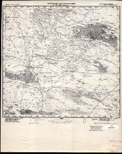
-
- Description:
- 1938
- Subject:
- Topical Subject: Maps, Topical Subject: Soviet Union, and Geographic Subject: Pola
- Publisher:
- Главное управление геодезии и картографии при СНК СССР
- Language:
- Russian
- Date Created:
- 1941
- Identifier:
- VAC9619-002179
- Genre:
- Topographic Maps and Military Maps
- Geographic Location:
- Coordinates: 57.6667, 31.5, 58, 32
- Related URL:
- Download GeoTIFF: https://drive.google.com/open?id=1zZnyMHQgQK-baO9C0ftoFCyAmTtGdxBD and Catalog URL: https://iucat.iu.edu/catalog/5020129
- Abstract:
- Modern area represented: Пола (Pola), Novgorodskaya oblast, Russia
- Call Number:
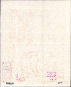
- G7000 s100 .S7 sheet O-36-76
- Caption:
- Captured map and Для служебного пользования
- City:
- Пола (Pola)
- Copyright Holder:
- No Copyright - United States
- Country:
- СССР (USSR)
- State/Province:
- РСФСР (RSFSR) and Ленинградская область (Leningrad oblast)
- Physical Description:
- Scale: 1:100,000
- Persistent URL:
- http://purl.dlib.indiana.edu/iudl/images/VAC9619/VAC9619-002179
- Provenance:
- DMA Topographic Center, Army Map Service Library, OMAHA, Library of Congress Geography & Map Division
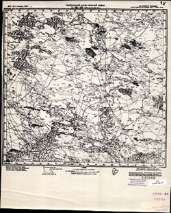
-
- Description:
- 1938
- Subject:
- Topical Subject: Soviet Union, Topical Subject: Maps, and Geographic Subject: Semenovshchina
- Publisher:
- Главное управление геодезии и картографии при СНК СССР
- Language:
- Russian
- Date Created:
- 1941
- Identifier:
- VAC9619-002180
- Genre:
- Topographic Maps and Military Maps
- Geographic Location:
- Coordinates: 57.6667, 32.5, 58, 33
- Related URL:
- Catalog URL: https://iucat.iu.edu/catalog/5020129 and Download GeoTIFF: https://drive.google.com/open?id=1IuWKZFYlg0ERFxDENwk3hpui7Kl6umeq
- Abstract:
- Modern area represented: Семеновщина (Semenovshchina), Novgorodskaya oblast, Russia
- Call Number:
- G7000 s100 .S7 sheet O-36-78
- Caption:
- Для служебного пользования and Captured map
- City:
- Семеновщина (Semenovshchina)
- Copyright Holder:
- No Copyright - United States
- Country:
- СССР (USSR)
- State/Province:
- РСФСР (RSFSR) and Ленинградская область (Leningrad oblast)
- Physical Description:
- Scale: 1:100,000
- Persistent URL:
- http://purl.dlib.indiana.edu/iudl/images/VAC9619/VAC9619-002180
- Provenance:
- DMA Topographic Center, Army Map Service Library, Library of Congress G & M Division
-
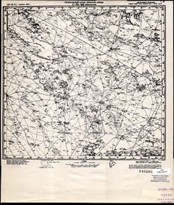
- Description:
- 1932
- Subject:
- Topical Subject: Maps, Topical Subject: Soviet Union, and Geographic Subject: Gorodtsy
- Publisher:
- Генеральный штаб Красной Армии
- Language:
- Russian
- Date Created:
- 1941
- Identifier:
- VAC9619-002178
- Genre:
- Topographic Maps and Military Maps
- Geographic Location:
- Coordinates: 57.6667, 30.5, 58, 31
- Related URL:
- Download GeoTIFF: https://drive.google.com/open?id=1QAgY2xhAalQhjh9UzwOLfFQR3KY04YLz and Catalog URL: https://iucat.iu.edu/catalog/5020129
- Abstract:
- Modern area represented: Городцы (Gorodtsy), Novgorodskaya oblast, Russia
- Call Number:
- G7000 s100 .S7 sheet O-36-74
- Caption:
- Для служебного пользования and Временное издание
- City:
- Городцы (Gorodtsy)
- Copyright Holder:
- No Copyright - United States
- Country:
- СССР (USSR)
- State/Province:
- Ленинградская область (Leningrad oblast) and РСФСР (RSFSR)
- Physical Description:
- Scale: 1:100,000
- Persistent URL:
- http://purl.dlib.indiana.edu/iudl/images/VAC9619/VAC9619-002178
- Provenance:
- DMA Topographic Center, Army Map Service Library, OMAHA, Library of Congress Geography & Map Division
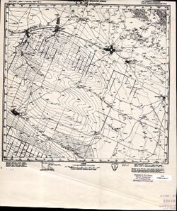
-
- Description:
- 1940
- Subject:
- Topical Subject: Soviet Union, Geographic Subject: Staryy Ryad, and Topical Subject: Maps
- Publisher:
- Генеральный штаб Красной Армии
- Language:
- Russian
- Identifier:
- VAC9619-002177
- Genre:
- Military Maps and Topographic Maps
- Geographic Location:
- Coordinates: 58, 34.5, 58.3333, 35
- Related URL:
- Download GeoTIFF: https://drive.google.com/open?id=11nLsX2aLzIHPmVtQzBBS7lMBu1VfWPWF and Catalog URL: https://iucat.iu.edu/catalog/5020129
- Abstract:
- Modern area represented: Старый Ряд (Staryy Ryad), Tverskaya oblast, Russia
- Call Number:
- G7000 s100 .S7 sheet O-36-70
- Caption:
- Captured map and Временное издание
- City:
- Старый Ряд (Staryy Ryad)
- Copyright Holder:
- No Copyright - United States
- Country:
- СССР (USSR)
- State/Province:
- Ленинградская область (Leningrad oblast), РСФСР (RSFSR), and Калининская область (Kalinin oblast)
- Physical Description:
- Scale: 1:100,000
- Persistent URL:
- http://purl.dlib.indiana.edu/iudl/images/VAC9619/VAC9619-002177
- Provenance:
- DMA Topographic Center, Army Map Service Library, OMAHA, Library of Congress Geography & Map Division
-
- Description:
- 1931
- Subject:
- Topical Subject: Maps, Geographic Subject: Kalmykia, and Topical Subject: Soviet Union
- Publisher:
- Генеральный штаб Красной Армии
- Language:
- Russian
- Date Created:
- 1942
- Identifier:
- VAC9619-002176
- Genre:
- Military Maps and Topographic Maps
- Geographic Location:
- Coordinates: 45, 46, 45.3333, 46.5
- Related URL:
- Download GeoTIFF: https://drive.google.com/open?id=1MvHSz2jfOIgPqmLdFhOfCUrV3zMi7GDM and Catalog URL: https://iucat.iu.edu/catalog/5020129
- Abstract:
- Modern area represented: Kalmykia, Russia
- Call Number:
- G7000 s100 .S7 sheet L-38-105
- Caption:
- Для служебного пользования
- City:
- Ферма №5 (Farm #5)
- Copyright Holder:
- No Copyright - United States
- Country:
- СССР (USSR)
- State/Province:
- Калмыцкая АССР (Kalmyk Autonomous Soviet Socialist Republic) and РСФСР (RSFSR)
- Physical Description:
- Scale: 1:100,000
- Persistent URL:
- http://purl.dlib.indiana.edu/iudl/images/VAC9619/VAC9619-002176
- Provenance:
- CIA Map Library
-
- Description:
- 1927
- Subject:
- Topical Subject: Soviet Union, Topical Subject: Maps, and Geographic Subject: Prikumskiy
- Publisher:
- Генеральный штаб Красной Армии
- Language:
- Russian
- Date Created:
- 1942
- Identifier:
- VAC9619-002175
- Genre:
- Topographic Maps and Military Maps
- Geographic Location:
- Coordinates: 45, 45.5, 45.3333, 46
- Related URL:
- Download GeoTIFF: https://drive.google.com/open?id=1oNieSvSiim9Nn6Cs0QFvFcMbSpYbCy7x and Catalog URL: https://iucat.iu.edu/catalog/5020129
- Abstract:
- Modern area represented: Prikumskiy, Kalmykiya Republic, Russia
- Call Number:
- G7000 s100 .S7 sheet L-38-104
- Caption:
- Для служебного пользования
- City:
- Свх. №109 Улан Туг (Ulan Tug)
- Copyright Holder:
- No Copyright - United States
- Country:
- СССР (USSR)
- State/Province:
- Калмыцкая АССР (Kalmyk Autonomous Soviet Socialist Republic), РСФСР (RSFSR), Кизлярский округ (Kizlyar district), and Орджоникидзевский край (Ordzhonikidze k...
- Physical Description:
- Scale: 1:100,000
- Persistent URL:
- http://purl.dlib.indiana.edu/iudl/images/VAC9619/VAC9619-002175
- Provenance:
- CIA Map Library
-
- Description:
- 1927
- Subject:
- Topical Subject: Soviet Union, Geographic Subject: Perekrestnyy, and Topical Subject: Maps
- Publisher:
- Генеральный штаб Красной Армии
- Language:
- Russian
- Date Created:
- 1942
- Identifier:
- VAC9619-002174
- Genre:
- Topographic Maps and Military Maps
- Geographic Location:
- Coordinates: 45, 45, 45.3333, 45.5
- Related URL:
- Download GeoTIFF: https://drive.google.com/open?id=1PufmFUSTdGToOsH9jP81y_oUAmZLg9iD and Catalog URL: https://iucat.iu.edu/catalog/5020129
- Abstract:
- Modern area represented: Perekrestnyy, Kalmykiya Republic, Russia
- Call Number:
- G7000 s100 .S7 sheet L-38-103
- Caption:
- Для служебного пользования
- City:
- Перекрестный (Perekrestnyy)
- Copyright Holder:
- No Copyright - United States
- Country:
- СССР (USSR)
- State/Province:
- Орджоникидзевский край (Ordzhonikidze kray), Калмыцкая АССР (Kalmyk Autonomous Soviet Socialist Republic), Кизлярский округ (Kizlyar district), and РСФСР (RS...
- Physical Description:
- Scale: 1:100,000
- Persistent URL:
- http://purl.dlib.indiana.edu/iudl/images/VAC9619/VAC9619-002174
- Provenance:
- CIA Map Library
-
- Description:
- 1927
- Subject:
- Topical Subject: Soviet Union, Geographic Subject: Priozerskoye, and Topical Subject: Maps
- Publisher:
- Генеральный штаб Красной Армии
- Language:
- Russian
- Date Created:
- 1942
- Identifier:
- VAC9619-002173
- Genre:
- Topographic Maps and Military Maps
- Geographic Location:
- Coordinates: 45, 44.5, 45.3333, 45
- Related URL:
- Catalog URL: https://iucat.iu.edu/catalog/5020129 and Download GeoTIFF: https://drive.google.com/open?id=1LlvgkdsTXJ8Qp1nijTGPecjQ-C4DXbIM
- Abstract:
- Modern area represented: Priozerskoye, Stavropol kray, Russia
- Call Number:
- G7000 s100 .S7 sheet L-38-102
- Caption:
- Для служебного пользования
- City:
- Мусса-Аджи (Mussa-Adzhi)
- Copyright Holder:
- No Copyright - United States
- Country:
- СССР (USSR)
- State/Province:
- Орджоникидзевский край (Ordzhonikidze kray) and РСФСР (RSFSR)
- Physical Description:
- Scale: 1:100,000
- Persistent URL:
- http://purl.dlib.indiana.edu/iudl/images/VAC9619/VAC9619-002173
- Provenance:
- CIA Map Library
-
- Description:
- 1926
- Subject:
- Topical Subject: Maps, Geographic Subject: Novoromanovskoye, Topical Subject: Soviet Union, and Geographic Subject: Stavropol' Krai
- Publisher:
- Генеральный штаб Красной Армии
- Language:
- Russian
- Date Created:
- 1942
- Identifier:
- VAC9619-002172
- Genre:
- Military Maps and Topographic Maps
- Geographic Location:
- Coordinates: 45, 44, 45.3333, 44.5
- Related URL:
- Download GeoTIFF: https://drive.google.com/open?id=1co-VKxsvx3pEAIsl5DU0bq5cEAAWVteN and Catalog URL: https://iucat.iu.edu/catalog/5020129
- Abstract:
- Modern area represented: Новоромановское (Novoromanovskoye), Stavropol' Krai, Russia
- Call Number:
- G7000 s100 .S7 sheet L-38-101
- Caption:
- Для cлужебного пользования
- City:
- Ново-Романовское (Novo-Romanovskoye)
- Copyright Holder:
- No Copyright - United States
- Country:
- СССР (USSR)
- State/Province:
- РСФСР (RSFSR) and Орджоникидзевский край (Ordzhonikidze kray)
- Physical Description:
- Scale: 1:100,000
- Persistent URL:
- http://purl.dlib.indiana.edu/iudl/images/VAC9619/VAC9619-002172
- Provenance:
- DMA Topographic Center, Army Map Service Library
-
- Description:
- 1927
- Subject:
- Geographic Subject: Alekseyevskoye, Topical Subject: Maps, and Topical Subject: Soviet Union
- Publisher:
- Генеральный штаб Красной Армии
- Language:
- Russian
- Date Created:
- 1941
- Identifier:
- VAC9619-002171
- Genre:
- Topographic Maps and Military Maps
- Geographic Location:
- Coordinates: 45, 43.5, 45.3333, 44
- Related URL:
- Catalog URL: https://iucat.iu.edu/catalog/5020129 and Download GeoTIFF: https://drive.google.com/open?id=1cqPxvYDxbmkWCf5XFwhksr-Axvqezxrv
- Abstract:
- Modern area represented: Alekseyevskoye, Stavropol Kray, Russia
- Call Number:
- G7000 s100 .S7 sheet L-38-100
- Caption:
- Для служебного пользования
- City:
- Алексеевское (Alekseyevskoye)
- Copyright Holder:
- No Copyright - United States
- Country:
- СССР (USSR)
- State/Province:
- РСФСР (RSFSR) and Орджоникидзевский край (Ordzhonikidze kray)
- Physical Description:
- Scale: 1:100,000
- Persistent URL:
- http://purl.dlib.indiana.edu/iudl/images/VAC9619/VAC9619-002171
- Provenance:
- DMA Topographic Center, Army Map Service Library
