
Search Constraints
Search Results
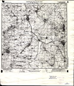
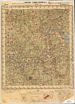
-
- Description:
- 1904
- Subject:
- Topical Subject: Maps, Geographic Subject: Rostov Oblast, Geographic Subject: Shakhty, and Topical Subject: Soviet Union
- Publisher:
- Генеральный штаб Красной Армии
- Language:
- Russian
- Date Created:
- 1941
- Identifier:
- VAC9619-001995
- Genre:
- Military Maps and Topographic Maps
- Geographic Location:
- Coordinates: 47.6667, 40, 48, 40.5
- Related URL:
- Catalog URL: https://iucat.iu.edu/catalog/5020129 and Download GeoTIFF: https://drive.google.com/open?id=1pYHY5iPg85CsGl7CRBdg5Vq1xYbRb1vC
- Abstract:
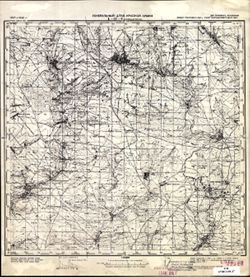
- Modern area represented: Шахты (Shakhty), Rostov Oblast, Russia
- Call Number:
- G7000 s100 .S7 sheet L-37-9
- Caption:
- Для cлужебного пользования
- City:
- Шахты (Shakhty)
- Copyright Holder:
- No Copyright - United States
- Country:
- СССР (USSR)
- State/Province:
- Ростовская область (Rostov oblast) and РСФСР (RSFSR)
- Physical Description:
- Scale: 1:100,000
- Persistent URL:
- http://purl.dlib.indiana.edu/iudl/images/VAC9619/VAC9619-001995
- Provenance:
- DMA Topographic Center, Army Map Service Library
-
- Description:
- 1904
- Subject:
- Geographic Subject: Novoshakhtinsk, Topical Subject: Soviet Union, and Topical Subject: Maps
- Publisher:
- Генеральный штаб Красной Армии
- Language:
- Russian
- Date Created:
- 1941
- Identifier:
- VAC9619-001994
- Genre:
- Topographic Maps and Military Maps
- Geographic Location:
- Coordinates: 47.6667, 39.5, 48, 40
- Related URL:
- Download GeoTIFF: https://drive.google.com/open?id=1Z71FJW1PPTeU6Zq-xJa1RdMaUeG9VcpI and Catalog URL: https://iucat.iu.edu/catalog/5020129
- Abstract:
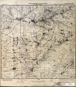
- Modern area represented: Novoshakhtinsk, Luhansk oblast, Ukraine
- Call Number:
- G7000 s100 .S7 sheet L-37-8
- Caption:
- Для служебного пользования
- City:
- Новошахтинск (Novoshakhtinsk)
- Copyright Holder:
- No Copyright - United States
- Country:
- СССР (USSR)
- State/Province:
- Ворошиловградская область (Voroshilovgrad oblast), Украинская ССР (Ukrainian Soviet Socialist Republic), Ростовская область (Rostov oblast), and РСФСР (RSFSR)
- Physical Description:
- Scale: 1:100,000
- Persistent URL:
- http://purl.dlib.indiana.edu/iudl/images/VAC9619/VAC9619-001994
- Provenance:
- CIA Map Library
-
- Description:
- 1902
- Subject:
- Geographic Subject: Dyakove, Topical Subject: Maps, Topical Subject: Soviet Union, and Geographic Subject: Luhansk
- Publisher:
- Генеральный штаб Красной Армии
- Language:
- Russian
- Date Created:
- 1941
- Identifier:
- VAC9619-001993
- Genre:
- Topographic Maps and Military Maps
- Geographic Location:
- Coordinates: 47.6667, 39, 48, 39.5
- Related URL:
- Catalog URL: https://iucat.iu.edu/catalog/5020129 and Download GeoTIFF: https://drive.google.com/open?id=1sq_QopHU0Yotfn_WLpGDPw_5Td4Y2ko5
- Abstract:
- Modern area represented: Dyakove, Luhansk, Ukraine
- Call Number:
- G7000 s100 .S7 sheet L-37-7
- Caption:
- Для служебного пользования
- City:
- Дьяково (Diakovo)
- Copyright Holder:
- No Copyright - United States
- Country:
- СССР (USSR)
- State/Province:
- Украинская ССР (Ukrainian Soviet Socialist Republic), Ростовская область (Rostov oblast), РСФСР (RSFSR), and Ворошиловградская область (Voroshilovgrad oblast)
- Physical Description:
- Scale: 1:100,000
- Persistent URL:
- http://purl.dlib.indiana.edu/iudl/images/VAC9619/VAC9619-001993
- Provenance:
- CIA Map Library
-
- Description:
- 1939
- Subject:
- Geographic Subject: Rostov, Geographic Subject: Kuybyshevo, Topical Subject: Soviet Union, and Topical Subject: Maps
- Publisher:
- Генеральный штаб Красной Армии
- Language:
- Russian
- Date Created:
- 1941
- Identifier:
- VAC9619-001992
- Genre:
- Topographic Maps and Military Maps
- Geographic Location:
- Coordinates: 47.6667, 38.5, 48, 39
- Related URL:
- Catalog URL: https://iucat.iu.edu/catalog/5020129 and Download GeoTIFF: https://drive.google.com/open?id=1BEDbT8LJBcGKTIxNNAWxHLz71wfCVjwA
- Abstract:
- Modern area represented: Куйбышево (Kuybyshevo), Rostov, Russia
- Call Number:
- G7000 s100 .S7 sheet L-37-6
- Caption:
- Для cлужебного пользования
- City:
- Куйбышево (Kuĭbyshevo)
- Copyright Holder:
- No Copyright - United States
- Country:
- СССР (USSR)
- State/Province:
- Ворошиловградская область (Voroshilovgrad oblast) and Украинская ССР (Ukrainian Soviet Socialist Republic)
- Physical Description:
- Scale: 1:100,000
- Persistent URL:
- http://purl.dlib.indiana.edu/iudl/images/VAC9619/VAC9619-001992
- Provenance:
- DMA Topographic Center
-
- Description:
- 1895
- Subject:
- Geographic Subject: Ilovays'k, Topical Subject: Soviet Union, and Topical Subject: Maps
- Publisher:
- Генеральный штаб Красной Армии
- Language:
- Russian
- Date Created:
- 1941
- Identifier:
- VAC9619-001991
- Genre:
- Military Maps and Topographic Maps
- Geographic Location:
- Coordinates: 47.6667, 38, 48, 38.5
- Related URL:
- Download GeoTIFF: https://drive.google.com/open?id=1kH7oS86WKdYFUSnKJLcOrEqzxFAZpxdS and Catalog URL: https://iucat.iu.edu/catalog/5020129
- Abstract:
- Modern area represented: Иловайск (Ilovays'k), Ukraine
- Call Number:
- G7000 s100 .S7 sheet L-37-5
- Caption:
- Для cлужебного пользования
- City:
- Иловайск (Ilovaĭsk)
- Copyright Holder:
- No Copyright - United States
- Country:
- СССР (USSR)
- State/Province:
- Украинская ССР (Ukrainian Soviet Socialist Republic) and Сталинская область (Stalino oblast)
- Physical Description:
- Scale: 1:100,000
- Persistent URL:
- http://purl.dlib.indiana.edu/iudl/images/VAC9619/VAC9619-001991
- Provenance:
- CIA Map Library
-
- Description:
- 1893
- Subject:
- Topical Subject: Maps, Topical Subject: Soviet Union, Geographic Subject: Kuibyshivs'kyi district, and Geographic Subject: Donetsk
- Publisher:
- Генеральный штаб Красной Армии
- Language:
- Russian
- Date Created:
- 1940
- Identifier:
- VAC9619-001990
- Genre:
- Topographic Maps and Military Maps
- Geographic Location:
- Coordinates: 47.6667, 37.5, 48, 38
- Related URL:
- Catalog URL: https://iucat.iu.edu/catalog/5020129 and Download GeoTIFF: https://drive.google.com/open?id=1A-5kl08Fmj97FOj3_cwBOc3JNpHC0Hcd
- Abstract:
- Modern area represented: Куйбышевский район (Kuibyshivs'kyi district), Donetsk, Ukraine
- Call Number:
- G7000 s100 .S7 sheet L-37-4
- Caption:
- Для cлужебного пользования
- City:
- Сталино (Stalino)
- Copyright Holder:
- No Copyright - United States
- Country:
- СССР (USSR)
- State/Province:
- Украинская ССР (Ukrainian Soviet Socialist Republic) and Сталинская область (Stalino oblast)
- Physical Description:
- Scale: 1:100,000
- Persistent URL:
- http://purl.dlib.indiana.edu/iudl/images/VAC9619/VAC9619-001990
- Provenance:
- DMA Topographic Center
-
- Description:
- 1940
- Subject:
- Geographic Subject: Kamenskoye, Geographic Subject: Tul'skaya oblast, Topical Subject: Soviet Union, and Topical Subject: Maps
- Publisher:
- Генеральный штаб Красной Армии
- Language:
- Russian
- Date Created:
- 1941
- Identifier:
- VAC9619-001989
- Genre:
- Topographic Maps and Military Maps
- Geographic Location:
- Coordinates: 53, 37.5, 53.3333, 38
- Related URL:
- Download GeoTIFF: https://drive.google.com/open?id=1OsUW3huvU0--ig3Z7ReiEGzhIgSu1zRs and Catalog URL: https://iucat.iu.edu/catalog/5020129
- Abstract:
- Modern area represented: Каменское (Kamenskoye), Тульская область (Tul'skaya oblast), Россия (Russia)
- Call Number:
- G7000 s100 .S7 sheet N-37-100
- Caption:
- Captured map
- City:
- Каменское (Kamenskoye)
- Copyright Holder:
- No Copyright - United States
- Country:
- СССР (USSR)
- State/Province:
- Тульская область (Tula oblast), Орловская область (Oryol oblast), and РСФСР (RSFSR)
- Physical Description:
- Scale: 1:100,000
- Persistent URL:
- http://purl.dlib.indiana.edu/iudl/images/VAC9619/VAC9619-001989
- Provenance:
- DMA Topographic Center, Army Map Service Library, Geographic Names Branch, OMAHA
-
- Description:
- 1931
- Subject:
- Topical Subject: Maps, Geographic Subject: Klintsy, and Topical Subject: Soviet Union
- Publisher:
- Генеральный штаб Красной Армии
- Language:
- Russian
- Date Created:
- 1941
- Identifier:
- VAC9619-001987
- Genre:
- Topographic Maps and Military Maps
- Geographic Location:
- Coordinates: 52.6667, 32, 53, 32.5
- Related URL:
- Download GeoTIFF: https://drive.google.com/open?id=1HzkqFfpuTNtRKd8KaZNj5YtZ5N3cNGTX and Catalog URL: https://iucat.iu.edu/catalog/5020129
- Abstract:
- Modern area represented: Klintsy, Bryansk oblast, Russia
- Call Number:
- G7000 s100 .S7 sheet N-36-113
- City:
- Клинцы (Klintsy)
- Copyright Holder:
- No Copyright - United States
- Country:
- СССР (USSR)
- State/Province:
- РСФСР (RSFSR) and Орловская область (Oryol oblast)
- Physical Description:
- Scale: 1:100,000
- Persistent URL:
- http://purl.dlib.indiana.edu/iudl/images/VAC9619/VAC9619-001987
- Provenance:
- DMA Topographic Center, Army Map Service Library, Geographic Names Branch, Atlasblatt
-
- Subject:
- Topical Subject: Soviet Union, Topical Subject: Maps, and Geographic Subject: Ruza
- Publisher:
- Главное Управление Геодезии и Картографии при СНК СССР
- Language:
- Russian
- Date Created:
- 1941
- Identifier:
- VAC9619-001988
- Genre:
- Military Maps and Topographic Maps
- Geographic Location:
- Coordinates: 55.6667, 36, 56, 36.5
- Related URL:
- Download GeoTIFF: https://drive.google.com/open?id=183z014zc6Fo65VnpwC5QfH0wkSz1d_qH and Catalog URL: https://iucat.iu.edu/catalog/5020129
- Abstract:
- Modern area represented: Ruza, Moscow oblast, Russia
- Call Number:
- G7000 s100 .S7 sheet N-37-1
- Caption:
- Для служебного пользования
- City:
- Руза (Ruza)
- Copyright Holder:
- No Copyright - United States
- Country:
- СССР (USSR)
- State/Province:
- Московская область (Moscow oblast) and РСФСР (RSFSR)
- Physical Description:
- Scale: 1:100,000
- Persistent URL:
- http://purl.dlib.indiana.edu/iudl/images/VAC9619/VAC9619-001988
- Provenance:
- DMA Topographic Center, Army Map Service Library, Geographic Names Branch, OMAHA
-
- Description:
- 1923
- Subject:
- Geographic Subject: Kazatskiye Bolsuny, Topical Subject: Maps, and Topical Subject: Soviet Union
- Publisher:
- Генеральный штаб Красной Армии
- Language:
- Russian
- Date Created:
- 1941
- Identifier:
- VAC9619-001986
- Genre:
- Military Maps and Topographic Maps
- Geographic Location:
- Coordinates: 52.6667, 31, 53, 31.5
- Related URL:
- Catalog URL: https://iucat.iu.edu/catalog/5020129 and Download GeoTIFF: https://drive.google.com/open?id=1NGZ48urLJWivl2Kfpc8aCV_5puUGsbqS
- Abstract:
- Modern area represented: Kazatskiye Bolsuny, Homyel voblasc, Belarus
- Call Number:
- G7000 s100 .S7 sheet N-36-111
- Caption:
- Для служебного пользования
- City:
- Казацкие Болсуны (Kazatskiye Bolsuny)
- Copyright Holder:
- No Copyright - United States
- Country:
- СССР (USSR)
- State/Province:
- РСФСР (RSFSR), Орловская область (Oryol oblast), Белорусская ССР (Byelorussian Soviet Socialist Republic), and Гомельская область (Homyel oblast)
- Physical Description:
- Scale: 1:100,000
- Persistent URL:
- http://purl.dlib.indiana.edu/iudl/images/VAC9619/VAC9619-001986
- Provenance:
- DMA Topographic Center, Army Map Service Library, Geographic Names Branch, Atlasblatt, OMAHA
