
Search Constraints
« Previous |
1 - 50 of 4,131
|
Next »
Search Results
-
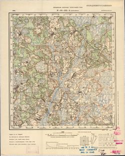
- Description:
- 1890
- Subject:
- Topical Subject: Maps, Geographic Subject: Kersleti, and Topical Subject: Soviet Union
- Publisher:
- Управление военных топографов
- Language:
- Russian
- Date Created:
- 1900
- Identifier:
- VAC9619-001670
- Genre:
- Topographic Maps and Military Maps
- Geographic Location:
- Coordinates: 59, 23, 59.167, 23.25
- Related URL:
- Catalog URL: http://iucat.iu.edu/catalog/5020131 and Download GeoTIFF: https://drive.google.com/open?id=1hbDmzQAiMfBU_L1SZkfcXjJgwchyfKjV
- Abstract:
- Modern area represented: Kersleti, Lääne county, Estonia
- Call Number:
- G7000 s50 .S68 sheet O-34-35-B
- City:
- Керслет (Kersleti)
- Copyright Holder:
- No Copyright - United States
- Country:
- Эстония (Estonia)
- Physical Description:
- Scale: 1:50,000
- Persistent URL:
- http://purl.dlib.indiana.edu/iudl/images/VAC9619/VAC9619-001670
- Provenance:
- DMA Topographic Center, OMAHA, Geographic Names Branch, Army Map Service Library, Library of Congress Geography & Map Division
-

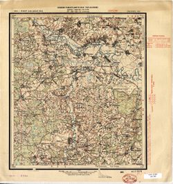
- Description:
- 1914
- Subject:
- Topical Subject: Soviet Union, Topical Subject: Maps, and Geographic Subject: Zakhonye
- Publisher:
- Управление военных топографов
- Language:
- Russian
- Date Created:
- 1925
- Identifier:
- VAC9619-001851
- Genre:
- Military Maps and Topographic Maps
- Geographic Location:
- Coordinates: 58.833, 29.25, 59, 29.5
- Related URL:
- Download GeoTIFF: https://drive.google.com/open?id=13eq_cnnXj2y4sziLGe95t8EKFYpjTMdS and Catalog URL: http://iucat.iu.edu/catalog/5020131
- Abstract:
- Modern area represented: Zakhonye, Russia
- Call Number:
- G7000 s50 .S68 sheet O-35-47-B
- Caption:
- Не подлежит оглашению,Captured map
- City:
- Захоноье (Zakhonye)
- Copyright Holder:
- No Copyright - United States
- Country:
- СССР (USSR)
- State/Province:
- РСФСР (RSFSR) and Ленинградская область (Leningrad oblast)
- Physical Description:
- Scale: 1:50,000
- Persistent URL:
- http://purl.dlib.indiana.edu/iudl/images/VAC9619/VAC9619-001851
- Provenance:
- Army Map Service Library, OMAHA, Library of Congress Geography & Map Division
-
- Description:
- 1936
- Subject:
- Geographic Subject: Ozero Vadozero, Topical Subject: Soviet Union, and Topical Subject: Maps
- Publisher:
- Управление военных топографов РККА
- Language:
- Russian
- Identifier:
- VAC9619-002568
- Genre:
- Topographic Maps and Military Maps
- Geographic Location:
- Coordinates: 67, 31, 67.333, 32
- Related URL:
- Download GeoTIFF: https://drive.google.com/file/d/1tQnrCvTr4D-7FlG7pcuATUnFg3cTE22e/view?usp=sharing and Catalog URL: https://iucat.iu.edu/catalog/5020129
- Abstract:
- Modern area represented: Ozero Vadozero, Murmansk oblast, Russia
- Call Number:
- G7000 s100 .S7 sheet Q-36-27
- Caption:
- Не подлежит оглашению,Captured map
- City:
- Вад-озеро (Ozero Vadozero)
- Copyright Holder:
- No Copyright - United States
- Country:
- СССР (USSR)
- State/Province:
- Ленинградская область (Leningrad oblast), РСФСР (RSFSR), and Карельская АССР (Karelian Autonomous Soviet Socialist Republic)
- Physical Description:
- Scale: 1:100,000
- Persistent URL:
- http://purl.dlib.indiana.edu/iudl/images/VAC9619/VAC9619-002568
- Provenance:
- DMA Topographic Center, Army Map Service Library, OMAHA
-
- Description:
- 1928
- Subject:
- Topical Subject: Soviet Union, Topical Subject: Maps, and Geographic Subject: Maryanovka
- Publisher:
- Управление военных топографов РККА
- Language:
- Russian
- Date Created:
- 1930
- Identifier:
- VAC9619-001170
- Genre:
- Military Maps and Topographic Maps
- Geographic Location:
- Coordinates: 48.167, 33.5, 48.333, 33.75
- Related URL:
- Catalog URL: http://iucat.iu.edu/catalog/5020131 and Download GeoTIFF: https://drive.google.com/open?id=1TcoQgF6oEgeExR6LG-eMJlucz0cQ0qyl
- Abstract:
- Modern area represented: Maryanovka, Dnipropetrovsk oblast, Ukraine
- Call Number:
- GM G7000 S50 .S68 M-36-140-A
- Caption:
- Не подлежит оглашению
- City:
- Марьяновка (Maryanovka)
- Copyright Holder:
- No Copyright - United States
- Country:
- СССР (USSR)
- State/Province:
- Днепропетровская область (Dnipropetrovsk oblast) and Украинская ССР (Ukrainian Soviet Socialist Republic)
- Physical Description:
- Scale: 1:50,000
- Persistent URL:
- http://purl.dlib.indiana.edu/iudl/images/VAC9619/VAC9619-001170
- Provenance:
- DMA Topographic Center, Army Map Service Library, OMAHA, Library of Congress Geography & Map Division
-
- Subject:
- Topical Subject: Soviet Union, Topical Subject: Maps, and Geographic Subject: Ruza
- Publisher:
- Главное Управление Геодезии и Картографии при СНК СССР
- Language:
- Russian
- Date Created:
- 1941
- Identifier:
- VAC9619-001988
- Genre:
- Military Maps and Topographic Maps
- Geographic Location:
- Coordinates: 55.6667, 36, 56, 36.5
- Related URL:
- Download GeoTIFF: https://drive.google.com/open?id=183z014zc6Fo65VnpwC5QfH0wkSz1d_qH and Catalog URL: https://iucat.iu.edu/catalog/5020129
- Abstract:
- Modern area represented: Ruza, Moscow oblast, Russia
- Call Number:
- G7000 s100 .S7 sheet N-37-1
- Caption:
- Для служебного пользования
- City:
- Руза (Ruza)
- Copyright Holder:
- No Copyright - United States
- Country:
- СССР (USSR)
- State/Province:
- Московская область (Moscow oblast) and РСФСР (RSFSR)
- Physical Description:
- Scale: 1:100,000
- Persistent URL:
- http://purl.dlib.indiana.edu/iudl/images/VAC9619/VAC9619-001988
- Provenance:
- DMA Topographic Center, Army Map Service Library, Geographic Names Branch, OMAHA
-
- Description:
- 1936
- Subject:
- Topical Subject: Maps, Topical Subject: Soviet Union, and Geographic Subject: Dubrova
- Publisher:
- Управление военных топографов РККА
- Language:
- Russian
- Identifier:
- VAC9619-000787
- Genre:
- Military Maps and Topographic Maps
- Geographic Location:
- Coordinates: 52.5, 29.25, 52.667, 29.5
- Related URL:
- Download GeoTIFF: https://drive.google.com/open?id=1exPyUC6LvIjyDpQjacJC9PC4HKAjtEPc and Catalog URL: http://iucat.iu.edu/catalog/5020131
- Abstract:
- Modern area represented: Dubrova, Homyel oblast, Belarus
- Call Number:
- G7000 s50 .s68 sheet N-35-131-B
- Caption:
- Не подлежит оглашению
- City:
- Дуброва (Dubrova)
- Copyright Holder:
- No Copyright - United States
- Country:
- СССР (USSR)
- State/Province:
- Белорусская ССР (Byelorussian Soviet Socialist Republic)
- Physical Description:
- Scale: 1:50,000
- Persistent URL:
- http://purl.dlib.indiana.edu/iudl/images/VAC9619/VAC9619-000787
- Provenance:
- M. I. Map Library, G000-30, GS, RA, OMAHA, Library of Congress Geography & Map Division, Army Map Service Library
-
- Description:
- 1936
- Subject:
- Topical Subject: Soviet Union, Geographic Subject: Pukhavichy, and Topical Subject: Maps
- Publisher:
- Управление военных топографов РККА
- Language:
- Russian
- Identifier:
- VAC9619-000652
- Genre:
- Topographic Maps and Military Maps
- Geographic Location:
- Coordinates: 53.5, 28.25, 53.667, 28.5
- Related URL:
- Download GeoTIFF: https://drive.google.com/open?id=1tc9WqkzkXMe1W75jNrY4b1YDitDO7sZs and Catalog URL: http://iucat.iu.edu/catalog/5020131
- Abstract:
- Modern area represented: Pukhavichy, Minsk oblast, Belarus
- Call Number:
- G7000 s50 .S68 sheet N-35-93-B
- Caption:
- Не подлежит оглашению,Captured map
- City:
- Пуховичи (Puhovichi)
- Copyright Holder:
- No Copyright - United States
- Country:
- СССР (USSR)
- State/Province:
- Белорусская ССР (Byelorussian Soviet Socialist Republic)
- Physical Description:
- Scale: 1:50,000
- Persistent URL:
- http://purl.dlib.indiana.edu/iudl/images/VAC9619/VAC9619-000652
- Provenance:
- Army Map Service Library, OMAHA, Library of Congress Geography & Map Division
-
- Description:
- 1936
- Subject:
- Topical Subject: Soviet Union, Geographic Subject: Zhitkovitsy, and Topical Subject: Maps
- Publisher:
- Управление военных топографов РККА
- Language:
- Russian
- Identifier:
- VAC9619-000024
- Genre:
- Military Maps and Topographic Maps
- Geographic Location:
- Coordinates: 58.667, 28.75, 58.833, 29
- Related URL:
- Catalog URL: http://iucat.iu.edu/catalog/5020131 and Download GeoTIFF: https://drive.google.com/open?id=1gAuIgkJWW_VNrb5GinG0F75CBMhYwjCr
- Abstract:
- Modern area represented: Zhitkovitsy, Russia
- Call Number:
- G7000 s50 .S68 sheet O-35-46-D
- Caption:
- Не подлежит оглашению ,Captured map,Duplicate
- City:
- Житковичи (Zhitkovitsy)
- Copyright Holder:
- No Copyright - United States
- Country:
- СССР (USSR)
- State/Province:
- РСФСР (RSFSR) and Ленинградская область (Leningrad oblast)
- Physical Description:
- Scale: 1:50,000
- Persistent URL:
- http://purl.dlib.indiana.edu/iudl/images/VAC9619/VAC9619-000024
- Provenance:
- Army Map Service Library, OMAHA, Library of Congress Geography & Map Division
-
- Subject:
- Topical Subject: Soviet Union, Topical Subject: Maps, and Geographic Subject: Suur-Selänpää
- Publisher:
- Генеральный штаб РККА
- Language:
- Russian
- Date Created:
- 1940
- Identifier:
- VAC9619-002379
- Genre:
- Military Maps and Topographic Maps
- Geographic Location:
- Coordinates: 61.0, 26.5, 61.333333, 27.0
- Related URL:
- Catalog URL: https://iucat.iu.edu/catalog/5020129 and Download GeoTIFF: https://drive.google.com/file/d/1IphV-fyNP5DuxyjjFppqeaSfcSPZJMh5/view?usp=sharing
- Abstract:
- Modern area represented: Suur-Selänpää, Kymenlaakso, Finland
- Call Number:
- G7000 s100 .S7 sheet P-35-102
- City:
- Селянпяя (Selänpää)
- Copyright Holder:
- No Copyright - United States
- Country:
- Финляндия (Finland)
- Physical Description:
- Scale: 1:100,000
- Persistent URL:
- http://purl.dlib.indiana.edu/iudl/images/VAC9619/VAC9619-002379
- Provenance:
- DMA Topographic Center, Army Map Service Library, OMAHA
-
- Description:
- 1936
- Subject:
- Topical Subject: Soviet Union, Topical Subject: Maps, and Geographic Subject: Valosavіchy
- Publisher:
- Управление военных топографов РККА
- Language:
- Russian
- Identifier:
- VAC9619-000785
- Genre:
- Military Maps and Topographic Maps
- Geographic Location:
- Coordinates: 52.5, 29, 52.667, 29.25
- Related URL:
- Download GeoTIFF: https://drive.google.com/open?id=1-0JtGuoRcAQOMue9zKRY1H90BFVHsJ9M and Catalog URL: http://iucat.iu.edu/catalog/5020131
- Abstract:
- Modern area represented: Valosavіchy, Homyel oblast, Belarus
- Call Number:
- G7000 s50 .s68 sheet N-35-131-A
- Caption:
- Не подлежит оглашению
- City:
- Волосовичи (Volosovichi)
- Copyright Holder:
- No Copyright - United States
- Country:
- СССР (USSR)
- State/Province:
- Белорусская ССР (Byelorussian Soviet Socialist Republic)
- Physical Description:
- Scale: 1:50,000
- Persistent URL:
- http://purl.dlib.indiana.edu/iudl/images/VAC9619/VAC9619-000785
- Provenance:
- M. I. Map Library, G000-30, GS, RA, Library of Congress Geography & Map Division
-
- Description:
- 1924
- Subject:
- Geographic Subject: Usvyatye, Topical Subject: Maps, and Topical Subject: Soviet Union
- Publisher:
- Военно-топографическое управление
- Language:
- Russian
- Identifier:
- VAC9619-001311
- Genre:
- Topographic Maps and Military Maps
- Geographic Location:
- Coordinates: 54.833, 33, 55, 33.25
- Related URL:
- Download GeoTIFF: https://drive.google.com/open?id=1AaD9cb-yeLx9Q9q3fqX2yj9TKMto0b91 and Catalog URL: http://iucat.iu.edu/catalog/5020131
- Abstract:
- Modern area represented: Usvyatye, Smolensk oblast, Russia
- Call Number:
- GM G7000 S50 .S68 N-36-43-A
- Caption:
- Секретно
- City:
- Усвятье (Usvyatye)
- Copyright Holder:
- No Copyright - United States
- Country:
- СССР (USSR)
- State/Province:
- РСФСР (RSFSR) and Западная область (Western oblast)
- Physical Description:
- Scale: 1:50,000
- Persistent URL:
- http://purl.dlib.indiana.edu/iudl/images/VAC9619/VAC9619-001311
- Provenance:
- Army Map Service Library, Library of Congress G & M Division, OMAHA
-
- Description:
- 1909
- Subject:
- Topical Subject: Soviet Union, Geographic Subject: Yarun, and Topical Subject: Maps
- Publisher:
- Управление военных топографов РККА
- Language:
- Russian
- Identifier:
- VAC9619-000223
- Genre:
- Topographic Maps and Military Maps
- Geographic Location:
- Coordinates: 50.5, 27.25, 50.667, 27.5
- Related URL:
- Download GeoTIFF: https://drive.google.com/open?id=17KmDaXN8x05zM3z-hw5VoHIxZVWjOqXH and Catalog URL: http://iucat.iu.edu/catalog/5020131
- Abstract:
- Modern area represented: Yarun, Zhytomyr oblast, Ukraine
- Call Number:
- G7000 s50 .S68 sheet M-35-55-B
- Caption:
- Не подлежит оглашению
- City:
- Ярунь (Yarun)
- Copyright Holder:
- No Copyright - United States
- Country:
- СССР (USSR)
- State/Province:
- Украинская ССР (Ukrainian Soviet Socialist Republic) and Киевская область (Kyiv oblast)
- Physical Description:
- Scale: 1:50,000
- Persistent URL:
- http://purl.dlib.indiana.edu/iudl/images/VAC9619/VAC9619-000223
- Provenance:
- DMA Topographic Center, Army Map Service Library, OMAHA, Library of Congress Geography & Map Division
-

- Description:
- 1928
- Subject:
- Geographic Subject: Surazh, Topical Subject: Soviet Union, and Topical Subject: Maps
- Publisher:
- Генеральный штаб Красной Армии
- Language:
- Russian
- Date Created:
- 1941
- Identifier:
- VAC9619-001977
- Genre:
- Topographic Maps and Military Maps
- Geographic Location:
- Coordinates: 53, 32, 53.3333, 32.5
- Related URL:
- Catalog URL: https://iucat.iu.edu/catalog/5020129 and Download GeoTIFF: https://drive.google.com/open?id=1beMyaj-VgbNaVBKPEMNn15PuoGtx7M9s
- Abstract:
- Modern area represented: Surazh, Bryansk oblast, Russia
- Call Number:
- G7000 s100 .S7 sheet N-36-101
- City:
- Сураж (Surazh)
- Copyright Holder:
- No Copyright - United States
- Country:
- СССР (USSR)
- State/Province:
- Могилевская область (Mogilev oblast), Белорусская ССР (Byelorussian Soviet Socialist Republic), РСФСР (RSFSR), and Орловская область (Oryol oblast)
- Physical Description:
- Scale: 1:100,000
- Persistent URL:
- http://purl.dlib.indiana.edu/iudl/images/VAC9619/VAC9619-001977
- Provenance:
- DMA Topographic Center, Army Map Service Library
-
- Description:
- 1936
- Subject:
- Geographic Subject: Voloshovo, Topical Subject: Maps, and Topical Subject: Soviet Union
- Publisher:
- Генеральный штаб РККА
- Language:
- Russian
- Date Created:
- 1937
- Identifier:
- VAC9619-001852
- Genre:
- Topographic Maps and Military Maps
- Geographic Location:
- Coordinates: 58.667, 29.25, 58.833, 29.5
- Related URL:
- Catalog URL: http://iucat.iu.edu/catalog/5020131 and Download GeoTIFF: https://drive.google.com/open?id=1pHva-PGBr0hpKzHfPowYax7ILfiz6wiD
- Abstract:
- Modern area represented: Voloshovo, Russia
- Call Number:
- G7000 s50 .S68 sheet O-35-47-D
- Caption:
- Не подлежит оглашению
- City:
- Волошово (Voloshovo)
- Copyright Holder:
- No Copyright - United States
- Country:
- СССР (USSR)
- State/Province:
- РСФСР (RSFSR) and Ленинградская область (Leningrad oblast)
- Physical Description:
- Scale: 1:50,000
- Persistent URL:
- http://purl.dlib.indiana.edu/iudl/images/VAC9619/VAC9619-001852
- Provenance:
- Army Map Service Library, OMAHA, Library of Congress Geography & Map Division
-
- Description:
- 1875
- Subject:
- Geographic Subject: Belgorod-Dnestrovskiy, Topical Subject: Soviet Union, and Topical Subject: Maps
- Publisher:
- Управление военных топографов РККА
- Language:
- Russian
- Date Created:
- 1929
- Identifier:
- VAC9619-001915
- Genre:
- Topographic Maps and Military Maps
- Geographic Location:
- Coordinates: 46, 30, 46.3333, 30.5
- Related URL:
- Catalog URL: https://iucat.iu.edu/catalog/5020129 and Download GeoTIFF: https://drive.google.com/file/d/1xTaeC4RlvKqjCHGORBzShnm74gH5QF17/view?usp=sharing
- Abstract:
- Modern area represented: Belgorod-Dnestrovskiy, Odessa oblast, Ukraine
- Call Number:
- G7000 s100 .S7 sheet L-36-61
- Caption:
- Не подлежит оглашению
- City:
- Аккерман (Akkerman)
- Copyright Holder:
- No Copyright - United States
- Country:
- СССР (USSR)
- State/Province:
- Бессарабия (Bessarabia) and Украинская ССР (Ukrainian Soviet Socialist Republic)
- Physical Description:
- Scale: 1:100,000
- Persistent URL:
- http://purl.dlib.indiana.edu/iudl/images/VAC9619/VAC9619-001915
- Provenance:
- DMA Topographic Center, Army Map Service Library, OMAHA
-
- Subject:
- Topical Subject: Maps, Topical Subject: Soviet Union, and Geographic Subject: Povenets
- Publisher:
- Itä-Karjalan kartasto
- Language:
- Russian
- Identifier:
- VAC9619-002500
- Genre:
- Topographic Maps and Military Maps
- Geographic Location:
- Coordinates: 62.667, 34.5, 63, 35
- Related URL:
- Download GeoTIFF: https://drive.google.com/file/d/11CTekGtzM6PCJt9U4WWXhs6PTTfpZKv2/view?usp=sharing and Catalog URL: https://iucat.iu.edu/catalog/5020129
- Abstract:
- Modern area represented: Повенец (Povenets), Медвежьегорский район (Medvezhyegorsky District), Republic of Karelia, Russia
- Call Number:
- G7000 s100 .S7 sheet P-36-46
- Caption:
- Captured map
- City:
- Повенец (Povenets)
- Copyright Holder:
- No Copyright - United States
- Physical Description:
- Scale: 1:100,000
- Persistent URL:
- http://purl.dlib.indiana.edu/iudl/images/VAC9619/VAC9619-002500
- Provenance:
- DMA Topographic Center, Army Map Service Library, OMAHA
-
- Description:
- 1936
- Subject:
- Topical Subject: Soviet Union, Geographic Subject: Osipovichi, and Topical Subject: Maps
- Publisher:
- Генеральный штаб Красной Армии
- Language:
- Russian
- Identifier:
- VAC9619-004110
- Genre:
- Topographic Maps and Military Maps
- Geographic Location:
- Coordinates: 53, 28.5, 53.333, 29
- Related URL:
- Catalog URL: https://iucat.iu.edu/catalog/5020129 and Download GeoTIFF: https://drive.google.com/file/d/1QHztwVY5BfNd2v6YqGnUlSEcglWhRTrs/view?usp=sharing
- Abstract:
- Modern area represented: Osipovichi, Belarus
- Call Number:
- G7000 s100 .S7 sheet N-35-106
- Caption:
- Не подлежит оглашению
- City:
- Осиповичи (Osipovichi)
- Copyright Holder:
- No Copyright - United States
- Country:
- СССР (USSR)
- State/Province:
- Полесская область (Polesia oblast), Могилевская область (Mogilev oblast), Белорусская ССР (Byelorussian Soviet Socialist Republic), and Минская область (Mins...
- Physical Description:
- Scale: 1:100,000
- Persistent URL:
- http://purl.dlib.indiana.edu/iudl/images/VAC9619/VAC9619-004110
- Provenance:
- DMA Topographic Center, Army Map Service Library, OMAHA
-
- Description:
- 1927
- Subject:
- Geographic Subject: Nelidovo, Topical Subject: Soviet Union, and Topical Subject: Maps
- Publisher:
- Военно-топографическое управление
- Language:
- Russian
- Identifier:
- VAC9619-003499
- Genre:
- Military Maps and Topographic Maps
- Geographic Location:
- Coordinates: 56.167, 32.75, 56.333, 33
- Related URL:
- Download GeoTIFF: https://drive.google.com/file/d/1lyldTXRTAWh4xkvxGY4qHYiAm3I1vIe8/view?usp=sharing and Catalog URL: http://iucat.iu.edu/catalog/5020131
- Abstract:
- Modern area represented: Нелидово (Nelidovo), Tverskaya oblast, Russia
- Call Number:
- G7000 s50 .S68 sheet O-36-138-B
- Caption:
- Секретно
- City:
- Нелидово (Nelidovo)
- Copyright Holder:
- No Copyright - United States
- Country:
- СССР (USSR)
- State/Province:
- РСФСР (RSFSR) and Западная область (Western oblast)
- Physical Description:
- Scale: 1:50,000
- Persistent URL:
- http://purl.dlib.indiana.edu/iudl/images/VAC9619/VAC9619-003499
- Provenance:
- Army Map Service Library, OMAHA, Library of Congress Geography & Map Division
-
- Subject:
- Topical Subject: Maps, Geographic Subject: Ostrava, and Topical Subject: Soviet Union
- Publisher:
- Генеральный штаб РККА
- Language:
- Russian
- Identifier:
- VAC9619-002870
- Genre:
- Topographic Maps and Military Maps
- Geographic Location:
- Coordinates: 49.667, 18, 50, 18.5
- Related URL:
- Catalog URL: https://iucat.iu.edu/catalog/5020129 and Download GeoTIFF: https://drive.google.com/file/d/1OjvHezWlaQqX0XjfRTSy9iu_7Zy4fWVy/view?usp=sharing
- Abstract:
- Modern area represented: Ostrava, Moravskoslezský region, Czech Republic
- Call Number:
- G7000 s100 .S7 sheet M-34-73
- City:
- Морав. Острава (Moravian Ostrava)
- Copyright Holder:
- No Copyright - United States
- Country:
- Германия (Germany) and Чехословакия (Czechoslovakia)
- Physical Description:
- Scale: 1:100,000
- Persistent URL:
- http://purl.dlib.indiana.edu/iudl/images/VAC9619/VAC9619-002870
- Provenance:
- DMA Topographic Center, Army Map Service Library, OMAHA
-

- Description:
- 1938
- Subject:
- Topical Subject: Maps, Geographic Subject: Krasnogvardeyskoe, and Topical Subject: Soviet Union
- Publisher:
- Главное управление геодезии и картографии при СНК СССР
- Language:
- Russian
- Date Created:
- 1941
- Identifier:
- VAC9619-002343
- Genre:
- Topographic Maps and Military Maps
- Geographic Location:
- Coordinates: 45.667, 41.5, 46, 42
- Related URL:
- Download GeoTIFF: https://drive.google.com/file/d/1AVr-cwCpH2TyChEw-jxKdVkFJnNQ8ff2/view?usp=sharing and Catalog URL: https://iucat.iu.edu/catalog/5020129
- Abstract:
- Modern area represented: Krasnogvardeyskoe, Stavropol kray, Russia
- Call Number:
- G7000 s100 .S7 sheet L-37-84
- Caption:
- Для служебного пользования
- City:
- Молотовское (Molotovskoe)
- Copyright Holder:
- No Copyright - United States
- Country:
- СССР (USSR)
- State/Province:
- Орджоникидзевский край (Ordzhonikidze kray), Калмыцкая АССР (Kalmyk Autonomous Soviet Socialist Republic), Ростовская область (Rostov oblast), and РСФСР (RSFSR)
- Physical Description:
- Scale: 1:100,000
- Persistent URL:
- http://purl.dlib.indiana.edu/iudl/images/VAC9619/VAC9619-002343
- Provenance:
- DMA Topographic Center, Army Map Service Library, OMAHA
-
- Description:
- 1873
- Subject:
- Geographic Subject: Jelgava, Topical Subject: Soviet Union, and Topical Subject: Maps
- Publisher:
- Генеральный штаб РККА
- Language:
- Russian
- Identifier:
- VAC9619-001747
- Genre:
- Topographic Maps and Military Maps
- Geographic Location:
- Coordinates: 56.5, 23.5, 56.667, 23.75
- Related URL:
- Catalog URL: http://iucat.iu.edu/catalog/5020131 and Download GeoTIFF: https://drive.google.com/file/d/1EQvZZ7nE0cO3OY_UMU_5ZZ8vDezC92AA/view?usp=sharing
- Abstract:
- Modern area represented: Jelgava, Zemgale region, Latvia
- Call Number:
- G7000 s50 .S68 sheet O-34-132-A
- City:
- Иелгава (Jelgava)
- Copyright Holder:
- No Copyright - United States
- Country:
- Латвия (Latvia)
- Physical Description:
- Scale: 1:50,000
- Persistent URL:
- http://purl.dlib.indiana.edu/iudl/images/VAC9619/VAC9619-001747
- Provenance:
- DMA Topographic Center, Army Map Service Library, Library of Congress Geography & Map Division
-
- Description:
- 1901
- Subject:
- Topical Subject: Maps, Geographic Subject: Utena, and Topical Subject: Soviet Union
- Publisher:
- Генеральный штаб РККА
- Language:
- Russian
- Date Created:
- 1903
- Identifier:
- VAC9619-004018
- Genre:
- Topographic Maps and Military Maps
- Geographic Location:
- Coordinates: 55.333, 25.5, 55.667, 26
- Related URL:
- Download GeoTIFF: https://drive.google.com/file/d/1pEEG0_-uG8tVJDX5J7ToJBZF8UXZ4fwm/view?usp=sharing and Catalog URL: https://iucat.iu.edu/catalog/5020129
- Abstract:
- Modern area represented: Utena, Lithuania
- Call Number:
- G7000 s100 .S7 sheet N-35-16
- City:
- Утена (Utena)
- Copyright Holder:
- No Copyright - United States
- Country:
- Литва (Lithuania) and Польша (Poland)
- Physical Description:
- Scale: 1:100,000
- Persistent URL:
- http://purl.dlib.indiana.edu/iudl/images/VAC9619/VAC9619-004018
- Provenance:
- DMA Topographic Center, Army Map Service Library
-
- Description:
- 1929
- Subject:
- Topical Subject: Soviet Union, Geographic Subject: Berezivka, and Topical Subject: Maps
- Publisher:
- Управление военных топографов РККА
- Language:
- Russian
- Date Created:
- 1930
- Identifier:
- VAC9619-001874
- Genre:
- Topographic Maps and Military Maps
- Geographic Location:
- Coordinates: 47, 30.5, 47.3333, 31
- Related URL:
- Catalog URL: https://iucat.iu.edu/catalog/5020129 and Download GeoTIFF: https://drive.google.com/open?id=1tjPZZpubs6FnCKvxrgC4b9CZsV8yHLrS
- Abstract:
- Modern area represented: Berezivka, Odessa oblast, Ukraine
- Call Number:
- G7000 s100 .S7 sheet L-36-26
- Caption:
- Не подлежит оглашению
- City:
- Березовка (Berezivka)
- Copyright Holder:
- No Copyright - United States
- Country:
- СССР (USSR)
- State/Province:
- Одесская область (Odessa oblast) and Украинская ССР (Ukrainian Soviet Socialist Republic)
- Physical Description:
- Scale: 1:100,000
- Persistent URL:
- http://purl.dlib.indiana.edu/iudl/images/VAC9619/VAC9619-001874
- Provenance:
- DMA Topographic Center, Army Map Service Library, Library of Congress Geography & Map Division
-
- Description:
- 1921
- Subject:
- Topical Subject: Soviet Union, Topical Subject: Maps, and Geographic Subject: Babinovichi
- Publisher:
- Военно-топографическое управление
- Language:
- Russian
- Date Created:
- 1925
- Identifier:
- VAC9619-001295
- Genre:
- Topographic Maps and Military Maps
- Geographic Location:
- Coordinates: 54.667, 30.5, 54.833, 30.75
- Related URL:
- Catalog URL: http://iucat.iu.edu/catalog/5020131 and Download GeoTIFF: https://drive.google.com/open?id=1_Q4SVzOXt8XYNsclfowImjTSHOUjzP4D
- Abstract:
- Modern area represented: Babinovichi, Vitebsk oblast, Belarus
- Call Number:
- GM G7000 S50 .S68 N-36-38-B
- Caption:
- Секретно
- City:
- Бабиновичи (Babinovichi)
- Copyright Holder:
- No Copyright - United States
- Country:
- СССР (USSR)
- State/Province:
- Белорусская ССР (Byelorussian Soviet Socialist Republic)
- Physical Description:
- Scale: 1:50,000
- Persistent URL:
- http://purl.dlib.indiana.edu/iudl/images/VAC9619/VAC9619-001295
- Provenance:
- DMA Topographic Center, Army Map Service Library, OMAHA, Library of Congress Geography & Map Division
-
- Description:
- 1927
- Subject:
- Topical Subject: Maps, Geographic Subject: Tyntsy, and Topical Subject: Soviet Union
- Publisher:
- Управление военных топографов РККА
- Language:
- Russian
- Identifier:
- VAC9619-002272
- Genre:
- Military Maps and Topographic Maps
- Geographic Location:
- Coordinates: 56.3333, 40.5, 56.6667, 41
- Related URL:
- Download GeoTIFF: https://drive.google.com/file/d/102D4vu1uG3HlLnspP2zmEKvXMZnMEkAk/view?usp=sharing and Catalog URL: https://iucat.iu.edu/catalog/5020129
- Abstract:
- Modern area represented: Тынцы (Tyntsy), Vladimirskaya oblast, Russia
- Call Number:
- G7000 s100 .S7 sheet O-37-130
- City:
- Тынцы (Tyntsy)
- Copyright Holder:
- No Copyright - United States
- Country:
- СССР (USSR)
- State/Province:
- РСФСР (RSFSR) and Ивановская область (Ivanovo oblast)
- Physical Description:
- Scale: 1:100,000
- Persistent URL:
- http://purl.dlib.indiana.edu/iudl/images/VAC9619/VAC9619-002272
- Provenance:
- DMA Topographic Center, Army Map Service Library
-

- Description:
- 1926
- Subject:
- Geographic Subject: Wieleń, Topical Subject: Soviet Union, and Topical Subject: Maps
- Publisher:
- Генеральный штаб Красной Армии
- Language:
- Russian
- Date Created:
- 1940
- Identifier:
- VAC9619-003881
- Genre:
- Topographic Maps and Military Maps
- Geographic Location:
- Coordinates: 52.667, 16, 53, 16.5
- Related URL:
- Catalog URL: https://iucat.iu.edu/catalog/5020129 and Download GeoTIFF: https://drive.google.com/file/d/1e0l5gZYZYukW5-SA95MhoYhbK0LMtX5h/view?usp=sharing
- Abstract:
- Modern area represented: Wieleń, Greater Poland, Poland
- Call Number:
- G7000 s100 .S7 sheet N-33-117
- City:
- Филене (Filehne)
- Copyright Holder:
- No Copyright - United States
- Country:
- Германия (Germany)
- Physical Description:
- Scale: 1:100,000
- Persistent URL:
- http://purl.dlib.indiana.edu/iudl/images/VAC9619/VAC9619-003881
- Provenance:
- DMA Topographic Center, Army Map Service Library, OMAHA, Library of Congress Geography & Map Division
-
- Subject:
- Topical Subject: Soviet Union, Geographic Subject: Skuodas, and Topical Subject: Maps
- Publisher:
- Генеральный штаб РККА
- Language:
- Russian
- Identifier:
- VAC9619-003168
- Genre:
- Topographic Maps and Military Maps
- Geographic Location:
- Coordinates: 56, 21.5, 56.333, 22
- Related URL:
- Catalog URL: https://iucat.iu.edu/catalog/5020129 and Download GeoTIFF: https://drive.google.com/file/d/1ITIWll6-34RO5OjTEt26w8ZFNfxb2R4g/view?usp=sharing
- Abstract:
- Modern area represented: Skuodas, Lithuania
- Call Number:
- G7000 s100 .S7 sheet O-34-140
- City:
- Скуодас (Skuodas)
- Copyright Holder:
- No Copyright - United States
- Country:
- Латвия (Latvia) and Литва (Lithuania)
- Physical Description:
- Scale: 1:100,000
- Persistent URL:
- http://purl.dlib.indiana.edu/iudl/images/VAC9619/VAC9619-003168
- Provenance:
- DMA Topographic Center, Army Map Service Library, OMAHA, Library of Congress Geography & Map Division, Geographic Names Branch
-

- Description:
- 1939
- Subject:
- Topical Subject: Maps, Geographic Subject: Yukhnov, and Topical Subject: Soviet Union
- Publisher:
- Генеральный штаб Красной Армии
- Language:
- Russian
- Date Created:
- 1941
- Identifier:
- VAC9619-004187
- Genre:
- Topographic Maps and Military Maps
- Geographic Location:
- Coordinates: 54.667, 35, 55, 35.5
- Related URL:
- Download GeoTIFF: https://drive.google.com/file/d/1cQNBivSSzsjyVCwoyr6v2BrCZDWttVf4/view?usp=sharing and Catalog URL: https://iucat.iu.edu/catalog/5020129
- Abstract:
- Modern area represented: Yukhnov, Kaluga oblast, Russia
- Call Number:
- G7000 s100 .S7 sheet N-36-47
- City:
- Юхнов (Yukhnov)
- Copyright Holder:
- No Copyright - United States
- Country:
- СССР (USSR)
- State/Province:
- Смоленская область (Smolensk oblast) and РСФСР (RSFSR)
- Physical Description:
- Scale: 1:100,000
- Persistent URL:
- http://purl.dlib.indiana.edu/iudl/images/VAC9619/VAC9619-004187
- Provenance:
- DMA Topographic Center, Army Map Service Library, OMAHA
-
- Description:
- 1893
- Subject:
- Geographic Subject: Ostrowiec Świętokrzyski, Topical Subject: Soviet Union, and Topical Subject: Maps
- Publisher:
- Генеральный штаб Красной Армии
- Language:
- Russian
- Date Created:
- 1940
- Identifier:
- VAC9619-002824
- Genre:
- Topographic Maps and Military Maps
- Geographic Location:
- Coordinates: 50.667, 21, 51, 21.5
- Related URL:
- Download GeoTIFF: https://drive.google.com/file/d/1dCs56aJfHbIoqFvjV3G6y_azZfMDjo25/view?usp=sharing and Catalog URL: https://iucat.iu.edu/catalog/5020129
- Abstract:
- Modern area represented: Ostrowiec Świętokrzyski, Świętokrzyskie province, Poland
- Call Number:
- G7000 s100 .S7 sheet M-34-43
- City:
- Островец (Ostrowiec)
- Copyright Holder:
- No Copyright - United States
- State/Province:
- Область государственных интересов Германии (Region of German state interests)
- Physical Description:
- Scale: 1:100,000
- Persistent URL:
- http://purl.dlib.indiana.edu/iudl/images/VAC9619/VAC9619-002824
- Provenance:
- DMA Topographic Center, OMAHA
-
- Description:
- 1883
- Subject:
- Geographic Subject: Săruleştii Noi, Topical Subject: Maps, and Topical Subject: Soviet Union
- Publisher:
- Генеральный штаб РККА
- Language:
- Russian
- Date Created:
- 1900
- Identifier:
- VAC9619-001797
- Genre:
- Topographic Maps and Military Maps
- Geographic Location:
- Coordinates: 44.3333, 26.5, 44.6667, 27
- Related URL:
- Download GeoTIFF: https://drive.google.com/open?id=1EesHE3L4H_0ViZpG8C0yFlmV2wsNjrkU and Catalog URL: https://iucat.iu.edu/catalog/5020129
- Abstract:
- Modern area represented: Săruleştii Noi, Călăraşi county, Romania
- Call Number:
- G7000 s100 .S7 sheet L-35-126
- City:
- Сэрулешти (Săruleştii)
- Copyright Holder:
- No Copyright - United States
- Country:
- Румыния (Romania)
- Physical Description:
- Scale: 1:100,000
- Persistent URL:
- http://purl.dlib.indiana.edu/iudl/images/VAC9619/VAC9619-001797
- Provenance:
- DMA Topographic Center, Army Map Service Library, OMAHA, Atlasblatt, Library of Congress Geography & Map Division
-
- Description:
- 1891
- Subject:
- Topical Subject: Maps, Geographic Subject: Korkia-aho, and Topical Subject: Soviet Union
- Publisher:
- Генеральный штаб РККА
- Language:
- Russian
- Identifier:
- VAC9619-002975
- Genre:
- Military Maps and Topographic Maps
- Geographic Location:
- Coordinates: 60.833, 28, 61, 28.25
- Related URL:
- Catalog URL: http://iucat.iu.edu/catalog/5020131 and Download GeoTIFF: https://drive.google.com/file/d/1XQ6m38IdPG84LmHqxFpPWIzLrUEOitzl/view?usp=sharing
- Call Number:
- GM G7000 s50 .S68 sheet P-35-117-A
- Caption:
- Временное издание
- City:
- Коркиаахо (Korkia-aho)
- Copyright Holder:
- No Copyright - United States
- Country:
- Финляндия (Finland)
- Physical Description:
- Scale: 1:50,000
- Persistent URL:
- http://purl.dlib.indiana.edu/iudl/images/VAC9619/VAC9619-002975
- Provenance:
- Army Map Service Library, OMAHA, Library of Congress Geography & Map Division
-

- Description:
- 1937
- Subject:
- Geographic Subject: Gummolovo and Topical Subject: Soviet Union
- Publisher:
- Главное управление государственной съемки и картографии НКВД СССР
- Language:
- Russian
- Date Created:
- 1941
- Identifier:
- VAC9619-000040
- Genre:
- Military Maps and Topographic Maps
- Geographic Location:
- Coordinates: 59.1667, 30.75, 59.3333, 31
- Related URL:
- Catalog URL: http://iucat.iu.edu/catalog/5020131 and Download GeoTIFF: https://drive.google.com/open?id=1Thglq8S3ntpZfPmHWFNFQ1QHmQpoR5Lu
- Abstract:
- Modern area represented: Gummolovo, Russia
- Call Number:
- G7000 s50 .S68 sheet O-36-26-B
- Caption:
- Для служебного пользования
- City:
- Гуммолово (Gummolovo)
- Copyright Holder:
- No Copyright - United States
- Country:
- СССР (USSR)
- State/Province:
- Ленинградская область (Leningrad oblast), Тосненский район (Tosnensky district), and РСФСР (RSFSR)
- Physical Description:
- Scale: 1:50,000
- Persistent URL:
- http://purl.dlib.indiana.edu/iudl/images/VAC9619/VAC9619-000040
- Provenance:
- Army Map Service Library, OMAHA, Library of Congress Geography & Map Division
-
- Description:
- 1929
- Subject:
- Geographic Subject: Kamenka, Topical Subject: Soviet Union, and Topical Subject: Maps
- Publisher:
- Военно-топографическое управление
- Language:
- Russian
- Identifier:
- VAC9619-003544
- Genre:
- Topographic Maps and Military Maps
- Geographic Location:
- Coordinates: 57.167, 31, 57.333, 31.25
- Related URL:
- Download GeoTIFF: https://drive.google.com/file/d/1lmBNnLm3Poz1CI8n_BfSwm8NcQNlU4M-/view?usp=sharing and Catalog URL: http://iucat.iu.edu/catalog/5020131
- Abstract:
- Modern area represented: Каменка (Kamenka), Novgorodskaya oblast, Russia
- Call Number:
- GM G7000 s50 .S68 sheet O-36-99-A
- Caption:
- Не подлежит оглашению
- City:
- Каменка (Kamenka)
- Copyright Holder:
- No Copyright - United States
- Country:
- СССР (USSR)
- State/Province:
- РСФСР (RSFSR), Западная область (Western oblast), and Ленинградская область (Leningrad oblast)
- Physical Description:
- Scale: 1:50,000
- Persistent URL:
- http://purl.dlib.indiana.edu/iudl/images/VAC9619/VAC9619-003544
- Provenance:
- DMA Topographic Center, Army Map Service Library, Library of Congress Geography & Map Division
-

- Subject:
- Topical Subject: Soviet Union, Topical Subject: Maps, and Geographic Subject: Novo-Biyskoye
- Publisher:
- Генеральный штаб РККА
- Language:
- Russian
- Date Created:
- 1940
- Identifier:
- VAC9619-003763
- Genre:
- Military Maps and Topographic Maps
- Geographic Location:
- Coordinates: 54.416667, 21.25, 54.5, 21.375
- Related URL:
- Download GeoTIFF: https://drive.google.com/file/d/12ADQ-KwvRsbz_NrkgrhOE6_uEKunq8Ac/view?usp=sharing and Catalog URL: https://iucat.iu.edu/catalog/14701157
- Abstract:
- Modern area represented: Ново-Бийское (Novo-Biyskoye), Kaliningradskaya oblast, Russia
- Call Number:
- G7063.K2 s25 .S6 sheet N-34-55-D-а
- Caption:
- Captured map
- City:
- Фридрихсвальде (Friedrichswalde)
- Copyright Holder:
- No Copyright - United States
- Country:
- Германия (Восточная Пруссия) (Germany (East Prussia))
- Physical Description:
- Scale: 1:25,000
- Persistent URL:
- http://purl.dlib.indiana.edu/iudl/images/VAC9619/VAC9619-003763
- Provenance:
- Army Map Service Library, OMAHA, Library of Congress Geography & Map Division
-

- Description:
- 1940
- Subject:
- Topical Subject: Maps, Geographic Subject: Озерна (Ozerna), and Topical Subject: Soviet Union
- Publisher:
- Генеральный штаб Красной Армии
- Language:
- Russian
- Date Created:
- 1943
- Identifier:
- VAC9619-000866
- Genre:
- Military Maps and Topographic Maps
- Geographic Location:
- Coordinates: 49.5, 25.25, 49.6667, 25.5
- Related URL:
- Download GeoTIFF: https://drive.google.com/open?id=1A_OYe8Hec_uBmt9L7Kk36TJzDvMQY32q and Catalog URL: http://iucat.iu.edu/catalog/5020131
- Abstract:
- Modern area represented: Озерна (Ozerna), Ternopil Oblast, Ukraine
- Call Number:
- G7000 s50 .S68 sheet M-35-87-B
- Caption:
- Для служебного пользования
- City:
- Езерна (Jezierna)
- Copyright Holder:
- No Copyright - United States
- Country:
- СССР (USSR)
- State/Province:
- Тарнопольская область (Tarnopolskaya oblast) and Украинская ССР (Ukrainian Soviet Socialist Republic)
- Physical Description:
- Scale: 1:50,000
- Persistent URL:
- http://purl.dlib.indiana.edu/iudl/images/VAC9619/VAC9619-000866
- Provenance:
- DMA Topographic Center, Army Map Service Library, Library of Congress Geography & Map Division
-

- Description:
- 1936
- Subject:
- Geographic Subject: Staryya Maksimavichy, Topical Subject: Maps, and Topical Subject: Soviet Union
- Publisher:
- Управление военных топографов РККА
- Language:
- Russian
- Identifier:
- VAC9619-000657
- Genre:
- Topographic Maps and Military Maps
- Geographic Location:
- Coordinates: 53.5, 29, 53.667, 29.25
- Related URL:
- Catalog URL: http://iucat.iu.edu/catalog/5020131 and Download GeoTIFF: https://drive.google.com/open?id=1A2R5hWH6Bx_hws0ztiyXWDWHVavpEUJz
- Abstract:
- Modern area represented: Staryya Maksimavichy, Mogilev oblast, Belarus
- Call Number:
- G7000 s50 .S68 sheet N-35-95-A
- Caption:
- Не подлежит оглашению,Captured map
- City:
- Старые Максимовичи (Starye Maksimovichi)
- Copyright Holder:
- No Copyright - United States
- Country:
- СССР (USSR)
- State/Province:
- Белорусская ССР (Byelorussian Soviet Socialist Republic)
- Physical Description:
- Scale: 1:50,000
- Persistent URL:
- http://purl.dlib.indiana.edu/iudl/images/VAC9619/VAC9619-000657
- Provenance:
- Army Map Service Library, OMAHA, Library of Congress Geography & Map Division
-
- Description:
- 1931
- Subject:
- Geographic Subject: Berezuvatka, Topical Subject: Maps, and Topical Subject: Soviet Union
- Publisher:
- Генеральный штаб Красной Армии
- Language:
- Russian
- Identifier:
- VAC9619-001168
- Genre:
- Topographic Maps and Military Maps
- Geographic Location:
- Coordinates: 48, 32.5, 48.167, 32.75
- Related URL:
- Download GeoTIFF: https://drive.google.com/open?id=1BeGb1-QilCzwus_0PRIJ69R1eUpbwagh and Catalog URL: http://iucat.iu.edu/catalog/5020131
- Abstract:
- Modern area represented: Berezuvatka, Kirovohrad oblast, Ukraine
- Call Number:
- GM G7000 S50 .S68 M-36-138-B
- Caption:
- Для служебного пользования
- City:
- Израилевка (Izrailevka)
- Copyright Holder:
- No Copyright - United States
- Country:
- СССР (USSR)
- State/Province:
- Кировоградская область (Kirovohrad oblast) and Украинская ССР (Ukrainian Soviet Socialist Republic)
- Physical Description:
- Scale: 1:50,000
- Persistent URL:
- http://purl.dlib.indiana.edu/iudl/images/VAC9619/VAC9619-001168
- Provenance:
- DMA Topographic Center, Army Map Service Library, Library of Congress Geography & Map Division
-

- Description:
- 1933
- Subject:
- Topical Subject: Soviet Union, Geographic Subject: Taman, and Topical Subject: Maps
- Publisher:
- Генеральный штаб Красной Армии
- Language:
- Russian
- Date Created:
- 1941
- Identifier:
- VAC9619-002358
- Genre:
- Topographic Maps and Military Maps
- Geographic Location:
- Coordinates: 45, 36.5, 45.333, 37
- Related URL:
- Download GeoTIFF: https://drive.google.com/file/d/1X763anMOD-wQf-npLvv0Rk-_nGzkuqHb/view?usp=sharing and Catalog URL: https://iucat.iu.edu/catalog/5020129
- Abstract:
- Modern area represented: Taman, Russia
- Call Number:
- G7000 s100 .S7 sheet L-37-98
- Caption:
- Для служебного пользования
- City:
- Тамань (Taman)
- Copyright Holder:
- No Copyright - United States
- Country:
- СССР (USSR)
- State/Province:
- РСФСР (RSFSR) and Краснодарский край (Krasnodar kray)
- Physical Description:
- Scale: 1:100,000
- Persistent URL:
- http://purl.dlib.indiana.edu/iudl/images/VAC9619/VAC9619-002358
- Provenance:
- DMA Topographic Center, Army Map Service Library, Library of Congress Geography & Map Division
-
- Subject:
- Topical Subject: Soviet Union, Geographic Subject: Radzymin, and Topical Subject: Maps
- Publisher:
- Генеральный штаб Красной Армии
- Language:
- Russian
- Date Created:
- 1941
- Identifier:
- VAC9619-000261
- Genre:
- Topographic Maps and Military Maps
- Geographic Location:
- Coordinates: 52.3333, 21, 52.5, 21.25
- Related URL:
- Download GeoTIFF: https://drive.google.com/open?id=1MGqJ3x9il9JlEmFwvpxgnBaQh9vtG1hD and Catalog URL: http://iucat.iu.edu/catalog/5020131
- Abstract:
- Modern area represented: Radzymin, Poland
- Call Number:
- G7000 s50 .S68 sheet N-34-127-C
- Caption:
- Captured map
- City:
- Радзымин (Radzymin)
- Copyright Holder:
- No Copyright - United States
- Country:
- Область государственных интересов Германии (Region of German state interest)
- Physical Description:
- Scale: 1:50,000
- Persistent URL:
- http://purl.dlib.indiana.edu/iudl/images/VAC9619/VAC9619-000261
- Provenance:
- Army Map Service Library, Library of Congress Geography & Map Division
-
- Description:
- 1931
- Subject:
- Topical Subject: Maps, Geographic Subject: Pavlysh, and Topical Subject: Soviet Union
- Publisher:
- Управление военных топографов РККА
- Language:
- Russian
- Date Created:
- 1932
- Identifier:
- VAC9619-001093
- Genre:
- Military Maps and Topographic Maps
- Geographic Location:
- Coordinates: 48.833, 33.25, 49, 33.5
- Related URL:
- Catalog URL: http://iucat.iu.edu/catalog/5020131 and Download GeoTIFF: https://drive.google.com/open?id=1sMRslNs7Ya7e0przcNxz1C8CJMYdNijj
- Abstract:
- Modern area represented: Pavlysh, Kirovohrad oblast, Ukraine
- Call Number:
- G7000 s50 .S68 М-36-115-Б
- Caption:
- Не подлежит оглашению
- City:
- Павлыш (Pavlysh)
- Copyright Holder:
- No Copyright - United States
- Country:
- СССР (USSR)
- State/Province:
- Харьковская область (Kharkiv oblast), Украинская ССР (Ukrainian Soviet Socialist Republic), and Днепропетровская область (Dnipropetrovsk oblast)
- Physical Description:
- Scale: 1:50,000
- Persistent URL:
- http://purl.dlib.indiana.edu/iudl/images/VAC9619/VAC9619-001093
- Provenance:
- DMA Topographic Center, Army Map Service Library, Library of Congress Geography & Map Division
-

- Description:
- 1923
- Subject:
- Topical Subject: Soviet Union, Topical Subject: Maps, and Geographic Subject: Kaniv
- Publisher:
- Генеральный штаб Красной Армии
- Language:
- Russian
- Date Created:
- 1938
- Identifier:
- VAC9619-003298
- Genre:
- Topographic Maps and Military Maps
- Geographic Location:
- Coordinates: 49.667, 31, 50, 31.5
- Related URL:
- Catalog URL: https://iucat.iu.edu/catalog/5020129 and Download GeoTIFF: https://drive.google.com/file/d/18uFdqJKy1Up9JM9AnfY5uG9_XJZ7gI2l/view?usp=sharing
- Abstract:
- Modern area represented: Kaniv, Cherkasy oblast, Ukraine
- Call Number:
- G7000 s100 .S7 sheet M-36-75
- Caption:
- Для служебного пользования
- City:
- Канев (Kaniv)
- Copyright Holder:
- No Copyright - United States
- Country:
- СССР (USSR)
- State/Province:
- Украинская ССР (Ukrainian Soviet Socialist Republic) and Киевская область (Kyiv oblast)
- Physical Description:
- Scale: 1:100,000
- Persistent URL:
- http://purl.dlib.indiana.edu/iudl/images/VAC9619/VAC9619-003298
- Provenance:
- DMA Topographic Center, Army Map Service Library, OMAHA, Library of Congress Geography & Map Division
-
- Description:
- 1927
- Subject:
- Topical Subject: Soviet Union, Topical Subject: Maps, and Geographic Subject: Tarzhepol'
- Publisher:
- Главное геодезическое управление
- Language:
- Russian
- Identifier:
- VAC9619-002556
- Genre:
- Topographic Maps and Military Maps
- Geographic Location:
- Coordinates: 61, 34, 61.333, 34.5
- Related URL:
- Catalog URL: https://iucat.iu.edu/catalog/5020129 and Download GeoTIFF: https://drive.google.com/file/d/1znEaZC6LKaPd3LRQXlzjNsGvDf9zhkGm/view?usp=sharing
- Abstract:
- Modern area represented: Таржеполь (Tarzhepol’), Republic of Karelia, Russia
- Call Number:
- G7000 s100 .S7 sheet P-36-105
- Caption:
- Не подлежит оглашению
- City:
- Таржеполь (Tarzhepol’)
- Copyright Holder:
- No Copyright - United States
- Country:
- СССР (USSR)
- State/Province:
- Ленинградская область (Leningrad oblast), РСФСР (RSFSR), and Карельская АССР (Karelian Autonomous Soviet Socialist Republic)
- Physical Description:
- Scale: 1:100,000
- Persistent URL:
- http://purl.dlib.indiana.edu/iudl/images/VAC9619/VAC9619-002556
- Provenance:
- DMA Topographic Center, Army Map Service Library, OMAHA
-
- Subject:
- Topical Subject: Maps, Geographic Subject: Lyuboml, and Topical Subject: Soviet Union
- Publisher:
- Управление военных топографов
- Language:
- Russian
- Date Created:
- 1891
- Identifier:
- VAC9619-000193
- Genre:
- Military Maps and Topographic Maps
- Geographic Location:
- Coordinates: 51.167, 24, 51.333, 24.25
- Related URL:
- Download GeoTIFF: https://drive.google.com/open?id=1w8ShRr1XZdo9wBCMn-f1ckMGagGqPeY0 and Catalog URL: http://iucat.iu.edu/catalog/5020131
- Abstract:
- Modern area represented: Lyuboml, Ukraine
- Call Number:
- G7000 s50 .S68 sheet M-35-25-A
- City:
- Любомль (Lyuboml)
- Copyright Holder:
- No Copyright - United States
- Country:
- Польша (Poland)
- Physical Description:
- Scale: 1:50,000
- Persistent URL:
- http://purl.dlib.indiana.edu/iudl/images/VAC9619/VAC9619-000193
- Provenance:
- DMA Topographic Center, Army Map Service Library, OMAHA
-
- Description:
- 1924
- Subject:
- Topical Subject: Maps, Geographic Subject: Makeyevskaya, and Topical Subject: Soviet Union
- Publisher:
- Генеральный штаб РККА
- Language:
- Russian
- Identifier:
- VAC9619-001307
- Genre:
- Topographic Maps and Military Maps
- Geographic Location:
- Coordinates: 54.833, 32.5, 55, 32.75
- Related URL:
- Download GeoTIFF: https://drive.google.com/open?id=1DEFCkvmGHh4AH9ZIP62l6ti-aIoTcev5 and Catalog URL: http://iucat.iu.edu/catalog/5020131
- Abstract:
- Modern area represented: Makeyevskaya, Smolensk oblast, Russia
- Call Number:
- GM G7000 S50 .S68 N-36-42-A
- Caption:
- Не подлежит оглашению,Рассекречено
- City:
- Макеево (Makeyevo)
- Copyright Holder:
- No Copyright - United States
- Country:
- СССР (USSR)
- State/Province:
- Смоленская область (Smolensk oblast) and РСФСР (RSFSR)
- Physical Description:
- Scale: 1:50,000
- Persistent URL:
- http://purl.dlib.indiana.edu/iudl/images/VAC9619/VAC9619-001307
- Provenance:
- DMA Topographic Center, Army Map Service Library, OMAHA, Library of Congress Geography & Map Division
-
- Description:
- 1924
- Subject:
- Topical Subject: Soviet Union, Topical Subject: Maps, and Geographic Subject: Klemyatino
- Publisher:
- Военно-топографическое управление
- Language:
- Russian
- Identifier:
- VAC9619-001310
- Genre:
- Military Maps and Topographic Maps
- Geographic Location:
- Coordinates: 54.667, 32.75, 54.833, 33
- Related URL:
- Catalog URL: http://iucat.iu.edu/catalog/5020131 and Download GeoTIFF: https://drive.google.com/open?id=1_GQ1ezPewXtI-Cyoge3d6wxuomHbz0i-
- Abstract:
- Modern area represented: Klemyatino, Smolensk oblast, Russia
- Call Number:
- GM G7000 S50 .S68 N-36-42-D
- Caption:
- Секретно
- City:
- Клемятино (Klemyatino)
- Copyright Holder:
- No Copyright - United States
- Country:
- СССР (USSR)
- State/Province:
- Западная область (Western oblast) and РСФСР (RSFSR)
- Physical Description:
- Scale: 1:50,000
- Persistent URL:
- http://purl.dlib.indiana.edu/iudl/images/VAC9619/VAC9619-001310
- Provenance:
- DMA Topographic Center, Army Map Service Library, OMAHA, Library of Congress Geography & Map Division
-
- Subject:
- Topical Subject: Soviet Union, Geographic Subject: Lipitsy, and Topical Subject: Maps
- Publisher:
- Генеральный штаб Красной Армии
- Language:
- Russian
- Date Created:
- 1941
- Identifier:
- VAC9619-003149
- Genre:
- Military Maps and Topographic Maps
- Geographic Location:
- Coordinates: 53.333, 37, 53.667, 37.5
- Related URL:
- Catalog URL: https://iucat.iu.edu/catalog/5020129 and Download GeoTIFF: https://drive.google.com/file/d/1DEJf3klsNOB3iIRfqpOPFMpm2cBBmWTF/view?usp=sharing
- Abstract:
- Modern area represented: Lipitsy, Tula oblast, Russia
- Call Number:
- G7000 s100 .S7 sheet N-37-87
- City:
- Липицы (Lipitsy)
- Copyright Holder:
- No Copyright - United States
- Country:
- СССР (USSR)
- State/Province:
- Тульская область (Tula oblast) and РСФСР (RSFSR)
- Physical Description:
- Scale: 1:100,000
- Persistent URL:
- http://purl.dlib.indiana.edu/iudl/images/VAC9619/VAC9619-003149
- Provenance:
- Army Map Service Library, Library of Congress G & M Division
-
- Subject:
- Topical Subject: Maps, Geographic Subject: Snizhkiv, and Topical Subject: Soviet Union
- Publisher:
- Генеральный штаб Красной Армии
- Language:
- Russian
- Identifier:
- VAC9619-001017
- Genre:
- Topographic Maps and Military Maps
- Geographic Location:
- Coordinates: 49.6667, 35.5, 49.8333, 35.75
- Related URL:
- Catalog URL: http://iucat.iu.edu/catalog/5020131 and Download GeoTIFF: https://drive.google.com/open?id=1V0QEdvoG-Kgn80R6QZ4hs9OY0tEmkfm-
- Abstract:
- Modern area represented: Сніжків (Snizhkiv), Kharkiv oblast, Ukraine
- Call Number:
- G7000 s50 .S68 sheet M-36-84-B
- Caption:
- Для служебного пользования
- City:
- Снежково (Snezhkovo)
- Copyright Holder:
- No Copyright - United States
- Country:
- СССР (USSR)
- State/Province:
- Харьковская область (Kharkiv oblast) and Украинская ССР (Ukrainian Soviet Socialist Republic)
- Physical Description:
- Scale: 1:50,000
- Persistent URL:
- http://purl.dlib.indiana.edu/iudl/images/VAC9619/VAC9619-001017
- Provenance:
- DMA Topographic Center, Army Map Service Library, OMAHA, Library of Congress Geography & Map Division
-
- Description:
- 1931
- Subject:
- Geographic Subject: Pyetrykaw, Topical Subject: Maps, and Topical Subject: Soviet Union
- Publisher:
- Генеральный штаб РККА
- Language:
- Russian
- Identifier:
- VAC9619-004142
- Genre:
- Military Maps and Topographic Maps
- Geographic Location:
- Coordinates: 52, 28, 52.333, 28.5
- Related URL:
- Download GeoTIFF: https://drive.google.com/file/d/1HjzPiHg85QtgZqzAUsOq1dV6-nvB3WYF/view?usp=sharing and Catalog URL: https://iucat.iu.edu/catalog/5020129
- Abstract:
- Modern area represented: Pyetrykaw, Homyel oblast, Belarus
- Call Number:
- G7000 s100 .S7 sheet N-35-141
- Caption:
- Не подлежит оглашению
- City:
- Петриков (Pyetrykaw)
- Copyright Holder:
- No Copyright - United States
- Country:
- СССР (USSR)
- State/Province:
- Белорусская ССР (Byelorussian Soviet Socialist Republic)
- Physical Description:
- Scale: 1:100,000
- Persistent URL:
- http://purl.dlib.indiana.edu/iudl/images/VAC9619/VAC9619-004142
- Provenance:
- DMA Topographic Center, Auswärtiges Amt. Geographischer Dienst, OMAHA, Army Map Service Library
-

- Description:
- 1939
- Subject:
- Topical Subject: Soviet Union, Geographic Subject: Komyshuvakha, and Topical Subject: Maps
- Publisher:
- Генеральный штаб Красной Армии
- Language:
- Russian
- Date Created:
- 1941
- Identifier:
- VAC9619-001844
- Genre:
- Military Maps and Topographic Maps
- Geographic Location:
- Coordinates: 47.6667, 35.5, 48, 36
- Related URL:
- Download GeoTIFF: https://drive.google.com/open?id=1IiavgxI6IZ79dkMzQI3jHmPsU86TTxOH and Catalog URL: https://iucat.iu.edu/catalog/5020129
- Abstract:
- Modern area represented: Komyshuvakha, Zaporizhia oblast, Ukraine
- Call Number:
- G7000 s100 .S7 sheet L-36-12
- Caption:
- Для служебного пользования
- City:
- Камышуваха (Komyshuvakha)
- Copyright Holder:
- No Copyright - United States
- Country:
- СССР (USSR)
- State/Province:
- Запорожская область (Zaporizhia oblast) and Украинская ССР (Ukrainian Soviet Socialist Republic)
- Physical Description:
- Scale: 1:100,000
- Persistent URL:
- http://purl.dlib.indiana.edu/iudl/images/VAC9619/VAC9619-001844
- Provenance:
- CIA Map Library
-

- Description:
- 1926
- Subject:
- Topical Subject: Soviet Union, Geographic Subject: Sirotskiy, and Topical Subject: Maps
- Publisher:
- Генеральный штаб Красной Армии
- Language:
- Russian
- Date Created:
- 1941
- Identifier:
- VAC9619-002461
- Genre:
- Military Maps and Topographic Maps
- Geographic Location:
- Coordinates: 47, 43, 47.333, 43.5
- Related URL:
- Download GeoTIFF: https://drive.google.com/file/d/1lKyxlwfueH8iSqR8tLrAkEEVeuu5mIWT/view?usp=sharing and Catalog URL: https://iucat.iu.edu/catalog/5020129
- Abstract:
- Modern area represented: Sirotskiy, Russia
- Call Number:
- G7000 s100 .S7 sheet L-38-27
- Caption:
- Для служебного пользования
- City:
- Сиротский (Sirotskiy)
- Copyright Holder:
- No Copyright - United States
- Country:
- СССР (USSR)
- State/Province:
- РСФСР (RSFSR) and Ростовская область (Rostov oblast)
- Physical Description:
- Scale: 1:100,000
- Persistent URL:
- http://purl.dlib.indiana.edu/iudl/images/VAC9619/VAC9619-002461
- Provenance:
- DMA Topographic Center, Army Map Service Library
