
Search Constraints
You searched for:
Country
Восточная Пруссия (East Prussia)
Remove constraint Country: Восточная Пруссия (East Prussia)
Subject
Topical Subject: Maps
Remove constraint Subject: Topical Subject: Maps
Search Results
-
- Description:
- 1910
- Subject:
- Geographic Subject: Gora Vyshka, Topical Subject: Soviet Union, and Topical Subject: Maps
- Publisher:
- Генеральный штаб Красной Армии
- Language:
- Russian
- Date Created:
- 1940
- Identifier:
- VAC9619-003585
- Genre:
- Topographic Maps and Military Maps
- Geographic Location:
- Coordinates: 55.167, 20.75, 55.25, 20.875
- Related URL:
- Download GeoTIFF: https://drive.google.com/file/d/1Kewy2gfGiTYuXyDWBAycNeLEZU9U5CiW/view?usp=sharing and Catalog URL: https://iucat.iu.edu/catalog/14701157
- Abstract:
- Modern area represented: Gora Vyshka, Kaliningrad oblast, Russia
- Call Number:
- G7063.K2 s25 .S6 sheet N-34-30-B-c
- City:
- Предин-Берг (Predinberg)
- Copyright Holder:
- No Copyright - United States
- Country:
- Германия (Germany) and Восточная Пруссия (East Prussia)
- Physical Description:
- Scale: 1:25,000
- Persistent URL:
- http://purl.dlib.indiana.edu/iudl/images/VAC9619/VAC9619-003585
- Provenance:
- CIA Map Branch -- Received, G000-30
-
- Subject:
- Geographic Subject: Preila, Topical Subject: Soviet Union, and Topical Subject: Maps
- Publisher:
- Генеральный штаб Красной Армии
- Language:
- Russian
- Date Created:
- 1940
- Identifier:
- VAC9619-003580
- Genre:
- Military Maps and Topographic Maps
- Geographic Location:
- Coordinates: 55.33333, 21.0, 55.416667, 21.125
- Related URL:
- Download GeoTIFF: https://drive.google.com/file/d/1o6JqVoJJ-l_X9hzi-gbflEHyKdQdjyWk/view?usp=sharing and Catalog URL: https://iucat.iu.edu/catalog/14701157
- Abstract:
- Modern area represented: Preila, Lithuania
- Call Number:
- G7063.K2 s25 .S6 sheet N-34-19-C-c
- City:
- Прейль (Preil)
- Copyright Holder:
- No Copyright - United States
- Country:
- Восточная Пруссия (East Prussia) and Германия (Germany)
- Physical Description:
- Scale: 1:25,000
- Persistent URL:
- http://purl.dlib.indiana.edu/iudl/images/VAC9619/VAC9619-003580
- Provenance:
- M. I. Map Library, G000-30, GS, RA
-
- Description:
- 1910
- Subject:
- Topical Subject: Maps, Topical Subject: Soviet Union, and Geographic Subject: Vaidaugai
- Publisher:
- Генеральный штаб Красной Армии
- Language:
- Russian
- Date Created:
- 1940
- Identifier:
- VAC9619-003575
- Genre:
- Military Maps and Topographic Maps
- Geographic Location:
- Coordinates: 55.583, 21.125, 55.667, 21.25
- Related URL:
- Catalog URL: https://iucat.iu.edu/catalog/14701157 and Download GeoTIFF: https://drive.google.com/file/d/1ENUdxTjt0Yew0sa9JFZsVlfV87z8pA3Y/view?usp=sharing
- Abstract:
- Modern area represented: Vaidaugai, Lithuania
- Call Number:
- G7063.K2 s25 .S6 sheet N-34-19-A-b
- City:
- Карлсберг (Karlsberg)
- Copyright Holder:
- No Copyright - United States
- Country:
- Восточная Пруссия (East Prussia) and Германия (Germany)
- Physical Description:
- Scale: 1:25,000
- Persistent URL:
- http://purl.dlib.indiana.edu/iudl/images/VAC9619/VAC9619-003575
- Provenance:
- DMA Topographic Center, Army Map Service Library, Library of Congress Geography & Map Division
-
- Description:
- 1910
- Subject:
- Topical Subject: Soviet Union, Geographic Subject: Meškų Dauba, and Topical Subject: Maps
- Publisher:
- Генеральный штаб Красной Армии
- Language:
- Russian
- Date Created:
- 1940
- Identifier:
- VAC9619-003574
- Genre:
- Military Maps and Topographic Maps
- Geographic Location:
- Coordinates: 55.583, 21, 55.667, 21.125
- Related URL:
- Catalog URL: https://iucat.iu.edu/catalog/14701157 and Download GeoTIFF: https://drive.google.com/file/d/1jn-aNRd1PbWQua5cDP_7MwVE_Mk4sm49/view?usp=sharing
- Abstract:
- Modern area represented: Meškų Dauba, Lithuania
- Call Number:
- G7063.K2 s25 .S6 sheet N-34-19-A-a
- City:
- Бэреншлухт (Berenshlukht)
- Copyright Holder:
- No Copyright - United States
- Country:
- Германия (Germany) and Восточная Пруссия (East Prussia)
- Physical Description:
- Scale: 1:25,000
- Persistent URL:
- http://purl.dlib.indiana.edu/iudl/images/VAC9619/VAC9619-003574
- Provenance:
- DMA Topographic Center, Army Map Service Library, Library of Congress Geography & Map Division
-
- Subject:
- Topical Subject: Maps, Geographic Subject: Klaipėda, and Topical Subject: Soviet Union
- Publisher:
- Генеральный штаб Красной Армии
- Language:
- Russian
- Date Created:
- 1940
- Identifier:
- VAC9619-003572
- Genre:
- Topographic Maps and Military Maps
- Geographic Location:
- Coordinates: 55.667, 21, 55.75, 21.125
- Related URL:
- Download GeoTIFF: https://drive.google.com/file/d/1ucGyZ3zOSP9dSG4wVOP7_laU1XD281Nc/view?usp=sharing and Catalog URL: https://iucat.iu.edu/catalog/14701157
- Abstract:
- Modern area represented: District of Klaipėda, Lithuania
- Call Number:
- G7063.K2 s25 .S6 sheet N-34-7-C-c
- City:
- Боммельсфитте (Bommelsvitte)
- Copyright Holder:
- No Copyright - United States
- Country:
- Восточная Пруссия (East Prussia) and Германия (Germany)
- Physical Description:
- Scale: 1:25,000
- Persistent URL:
- http://purl.dlib.indiana.edu/iudl/images/VAC9619/VAC9619-003572
- Provenance:
- DMA Topographic Center, Army Map Service Library, Library of Congress Geography & Map Division
-
- Subject:
- Geographic Subject: Janowo, Topical Subject: Soviet Union, and Topical Subject: Maps
- Publisher:
- Генеральный штаб Красной Армии
- Language:
- Russian
- Date Created:
- 1941
- Identifier:
- VAC9619-000369
- Genre:
- Military Maps and Topographic Maps
- Geographic Location:
- Coordinates: 53.1667, 20.5, 53.3333, 20.75
- Related URL:
- Catalog URL: http://iucat.iu.edu/catalog/5020131 and Download GeoTIFF: https://drive.google.com/open?id=1UYLIVjiuM5rVviviizhQkKcRS6_koE_z
- Abstract:
- Modern area represented: Janowo, Poland
- Call Number:
- G7000 s50 .S68 sheet N-34-102-A
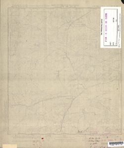
- Caption:
- Captured map
- City:
- Яново (Janowo)
- Copyright Holder:
- No Copyright - United States
- Country:
- Германия (Germany), Восточная Пруссия (East Prussia), and Область государственных интересов Германии (Region of German state interest)
- Physical Description:
- Scale: 1:50,000
- Persistent URL:
- http://purl.dlib.indiana.edu/iudl/images/VAC9619/VAC9619-000369
- Provenance:
- DMA Topographic Center, Army Map Service Library, OMAHA, Library of Congress Geography & Map Division
-

- Subject:
- Topical Subject: Soviet Union, Geographic Subject: Chorzele, and Topical Subject: Maps
- Publisher:
- Генеральный штаб Красной Армии
- Language:
- Russian
- Date Created:
- 1941
- Identifier:
- VAC9619-000370
- Genre:
- Military Maps and Topographic Maps
- Geographic Location:
- Coordinates: 53.1667, 20.75, 53.3333, 21
- Related URL:
- Download GeoTIFF: https://drive.google.com/open?id=1eT_SRLdiphOMmD85IKw1gqQJSPCLmqJ_ and Catalog URL: http://iucat.iu.edu/catalog/5020131
- Abstract:
- Modern area represented: Chorzele, Poland
- Call Number:
- G7000 s50 .S68 sheet N-34-102-B
- City:
- Хожеле (Khozhele)
- Copyright Holder:
- No Copyright - United States
- Country:
- Область государственных интересов Германии (Region of German state interest), Германия (Germany), and Восточная Пруссия (East Prussia)
- Physical Description:
- Scale: 1:50,000
- Persistent URL:
- http://purl.dlib.indiana.edu/iudl/images/VAC9619/VAC9619-000370
- Provenance:
- DMA Topographic Center, Army Map Service Library, OMAHA, Library of Congress Geography & Map Division
-
- Subject:
- Topical Subject: Soviet Union, Geographic Subject: Ruciane-Nida, and Topical Subject: Maps
- Publisher:
- Генеральный штаб Красной Армии
- Language:
- Russian
- Date Created:
- 1941
- Identifier:
- VAC9619-000368
- Genre:
- Topographic Maps and Military Maps
- Geographic Location:
- Coordinates: 53.5, 21.5, 53.6667, 21.75
- Related URL:
- Catalog URL: http://iucat.iu.edu/catalog/5020131 and Download GeoTIFF: https://drive.google.com/open?id=1cqfVzcKVjXpLIWrub-fJQ-nPwWYVhexU
- Abstract:
- Modern area represented: Ruciane-Nida, Poland
- Call Number:
- G7000 s50 .S68 sheet N-34-92-A
- Caption:
- Captured map
- City:
- Рудшанни (Rudczanny)
- Copyright Holder:
- No Copyright - United States
- Country:
- Восточная Пруссия (East Prussia) and Германия (Germany)
- Physical Description:
- Scale: 1:50,000
- Persistent URL:
- http://purl.dlib.indiana.edu/iudl/images/VAC9619/VAC9619-000368
- Provenance:
- DMA Topographic Center, Army Map Service Library, OMAHA, Library of Congress Geography & Map Division
-
- Subject:
- Topical Subject: Soviet Union, Geographic Subject: Myszyniec, and Topical Subject: Maps
- Publisher:
- Генеральный штаб Красной Армии
- Language:
- Russian
- Date Created:
- 1941
- Identifier:
- VAC9619-000367
- Genre:
- Topographic Maps and Military Maps
- Geographic Location:
- Coordinates: 53.3333, 21.25, 53.5, 21.5
- Related URL:
- Catalog URL: http://iucat.iu.edu/catalog/5020131 and Download GeoTIFF: https://drive.google.com/open?id=1FYXXnu6YQ3Mr7ySKdf7m7E2v6f7ARySH
- Abstract:
- Modern area represented: Myszyniec, Poland
- Call Number:
- G7000 s50 .S68 sheet N-34-91-D
- Caption:
- Captured map
- City:
- Мышинец (Myszyniec)
- Copyright Holder:
- No Copyright - United States
- Country:
- Германия (Germany), Область государственных интересов Германии (Region of German state interest), and Восточная Пруссия (East Prussia)
- Physical Description:
- Scale: 1:50,000
- Persistent URL:
- http://purl.dlib.indiana.edu/iudl/images/VAC9619/VAC9619-000367
- Provenance:
- DMA Topographic Center, Army Map Service Library, Library of Congress Geography & Map Division
-
- Subject:
- Topical Subject: Soviet Union, Geographic Subject: Spychowo, and Topical Subject: Maps
- Publisher:
- Генеральный штаб Красной Армии
- Language:
- Russian
- Date Created:
- 1941
- Identifier:
- VAC9619-000366
- Genre:
- Topographic Maps and Military Maps
- Geographic Location:
- Coordinates: 53.5, 31.25, 53.6667, 21.5
- Related URL:
- Download GeoTIFF: https://drive.google.com/open?id=1qNjA3RB4RaacgakVhP6dvQxEKhBfNvbo and Catalog URL: http://iucat.iu.edu/catalog/5020131
- Abstract:
- Modern area represented: Spychowo, Poland
- Call Number:
- G7000 s50 .S68 sheet N-34-91-B
- Caption:
- Captured map
- City:
- Пуппен (Puppen)
- Copyright Holder:
- No Copyright - United States
- Country:
- Германия (Germany) and Восточная Пруссия (East Prussia)
- Physical Description:
- Scale: 1:50,000
- Persistent URL:
- http://purl.dlib.indiana.edu/iudl/images/VAC9619/VAC9619-000366
- Provenance:
- DMA Topographic Center, Army Map Service Library, OMAHA, Library of Congress Geography & Map Division
