
Search Constraints
You searched for:
Date Created
1929
Remove constraint Date Created: 1929
Provenance
DMA Topographic Center, Army Map Service Library, OMAHA
Remove constraint Provenance: DMA Topographic Center, Army Map Service Library, OMAHA
1 - 5 of 5
Search Results
-
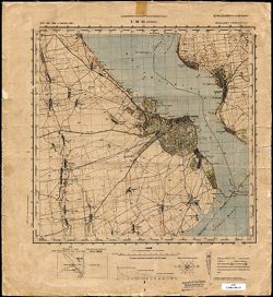
- Description:
- 1923
- Subject:
- Topical Subject: Maps, Geographic Subject: Mikulino, and Topical Subject: Soviet Union
- Publisher:
- Генеральный штаб Красной Армии
- Language:
- Russian
- Date Created:
- 1929
- Identifier:
- VAC9619-004166
- Genre:
- Topographic Maps and Military Maps
- Geographic Location:
- Coordinates: 55, 31, 55.333, 31.5
- Related URL:
- Download GeoTIFF: https://drive.google.com/file/d/1AsN_7PHMgiqIo27Jr2t1YGsQSAA7zHEl/view?usp=sharing and Catalog URL: https://iucat.iu.edu/catalog/5020129
- Abstract:
- Modern area represented: Mikulino, Vitebsk oblast, Belarus
- Call Number:
- G7000 s100 .S7 sheet N-36-27
- Caption:
- Для служебного пользования
- City:
- Микулино (Mikulino)
- Copyright Holder:
- No Copyright - United States
- Country:
- СССР (USSR)
- State/Province:
- Белорусская ССР (Byelorussian Soviet Socialist Republic), РСФСР (RSFSR), Смоленская область (Smolensk oblast), and Витебская область (Vitebsk oblast)
- Physical Description:
- Scale: 1:100,000
- Persistent URL:
- http://purl.dlib.indiana.edu/iudl/images/VAC9619/VAC9619-004166
- Provenance:
- DMA Topographic Center, Army Map Service Library, OMAHA
-

- Description:
- 1914
- Subject:
- Topical Subject: Maps, Topical Subject: Soviet Union, and Geographic Subject: Mrągowo
- Publisher:
- Генеральный штаб РККА
- Language:
- Russian
- Date Created:
- 1929
- Identifier:
- VAC9619-003946
- Genre:
- Military Maps and Topographic Maps
- Geographic Location:
- Coordinates: 53.667, 21, 54, 21.5
- Related URL:
- Catalog URL: https://iucat.iu.edu/catalog/5020129 and Download GeoTIFF: https://drive.google.com/file/d/1j2UJ0lvcthIXy-COKvAtCYtiRBgOQEfx/view?usp=sharing
- Abstract:
- Modern area represented: Mrągowo, Warmia-Masuria, Poland
- Call Number:
- G7000 s100 .S7 sheet N-34-79
- City:
- Зенсбург (Sensburg)
- Copyright Holder:
- No Copyright - United States
- State/Province:
- Восточная Пруссия (East Prussia), Алленштайнская провинция (Allenstein province), and Кенигсбергская провинция (Königsberg province)
- Physical Description:
- Scale: 1:100,000
- Persistent URL:
- http://purl.dlib.indiana.edu/iudl/images/VAC9619/VAC9619-003946
- Provenance:
- DMA Topographic Center, Army Map Service Library, OMAHA
-
- Description:
- 1911
- Subject:
- Topical Subject: Maps, Topical Subject: Soviet Union, and Geographic Subject: Zblewo
- Publisher:
- Генеральный штаб РККА
- Language:
- Russian
- Date Created:
- 1929
- Identifier:
- VAC9619-003941
- Genre:
- Topographic Maps and Military Maps
- Geographic Location:
- Coordinates: 53.667, 18, 54, 18.5
- Related URL:
- Catalog URL: https://iucat.iu.edu/catalog/5020129 and Download GeoTIFF: https://drive.google.com/file/d/1dBvNtil78at3rfiUQctHXeRInWeyy0u0/view?usp=sharing
- Abstract:
- Modern area represented: Zblewo, Pomeranian voivodeship, Poland
- Call Number:
- G7000 s100 .S7 sheet N-34-73
- City:
- Зблево (Zblewo)
- Copyright Holder:
- No Copyright - United States
- Country:
- Германия (Germany)
- Physical Description:
- Scale: 1:100,000
- Persistent URL:
- http://purl.dlib.indiana.edu/iudl/images/VAC9619/VAC9619-003941
- Provenance:
- DMA Topographic Center, Army Map Service Library, OMAHA
-
- Description:
- 1908
- Subject:
- Topical Subject: Maps, Topical Subject: Soviet Union, and Geographic Subject: Braniewo
- Publisher:
- Генеральный штаб РККА
- Language:
- Russian
- Date Created:
- 1929
- Identifier:
- VAC9619-003921
- Genre:
- Topographic Maps and Military Maps
- Geographic Location:
- Coordinates: 54.333, 19.5, 54.667, 20
- Related URL:
- Download GeoTIFF: https://drive.google.com/file/d/1oosx-o3snhceYiYZarA03o7dgrMkpt5O/view?usp=sharing and Catalog URL: https://iucat.iu.edu/catalog/5020129
- Abstract:
- Modern area represented: Braniewo, Warmia-Masuria, Poland
- Call Number:
- G7000 s100 .S7 sheet N-34-52
- City:
- Браунсберг (Braunsberg)
- Copyright Holder:
- No Copyright - United States
- State/Province:
- Восточная Пруссия (East Prussia) and Кенигсбергская провинция (Königsberg province)
- Physical Description:
- Scale: 1:100,000
- Persistent URL:
- http://purl.dlib.indiana.edu/iudl/images/VAC9619/VAC9619-003921
- Provenance:
- DMA Topographic Center, Army Map Service Library, OMAHA
-
- Description:
- 1875
- Subject:
- Geographic Subject: Belgorod-Dnestrovskiy, Topical Subject: Soviet Union, and Topical Subject: Maps
- Publisher:
- Управление военных топографов РККА
- Language:
- Russian
- Date Created:
- 1929
- Identifier:
- VAC9619-001915
- Genre:
- Topographic Maps and Military Maps
- Geographic Location:
- Coordinates: 46, 30, 46.3333, 30.5
- Related URL:
- Catalog URL: https://iucat.iu.edu/catalog/5020129 and Download GeoTIFF: https://drive.google.com/file/d/1xTaeC4RlvKqjCHGORBzShnm74gH5QF17/view?usp=sharing
- Abstract:
- Modern area represented: Belgorod-Dnestrovskiy, Odessa oblast, Ukraine
- Call Number:
- G7000 s100 .S7 sheet L-36-61
- Caption:
- Не подлежит оглашению
- City:
- Аккерман (Akkerman)
- Copyright Holder:
- No Copyright - United States
- Country:
- СССР (USSR)
- State/Province:
- Бессарабия (Bessarabia) and Украинская ССР (Ukrainian Soviet Socialist Republic)
- Physical Description:
- Scale: 1:100,000
- Persistent URL:
- http://purl.dlib.indiana.edu/iudl/images/VAC9619/VAC9619-001915
- Provenance:
- DMA Topographic Center, Army Map Service Library, OMAHA
