Indiana University
Indiana University
IU
Skip to Content
Digital Collections
Toggle navigation
Digital
Collections
Switch language
English
Switch language
Deutsch
English
Español
Français
Italiano
Português do Brasil
中文
Login
Home
About
Contact
Search Digital Collections
Go
×
Search Constraints
Start Over
You searched for:
Date Created
1931
Remove constraint Date Created: 1931
Holding Location
B-WELLS
Remove constraint Holding Location: B-WELLS
« Previous |
1
-
10
of
65
|
Next »
Sort by relevance ▼
relevance ▼
recently updated
title ▲
title ▼
date created ▲
date created ▼
pages ▲
pages ▼
collection size ▲
collection size ▼
Number of results to display per page
10 per page
10
per page
20
per page
50
per page
100
per page
View results as:
List
Gallery
Masonry
Search Results
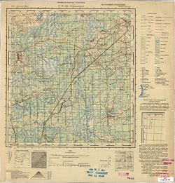
N-36-133-В Омельковщина
N-36-133-А Короватичи
N-36-121-В Гавеновичи
N-35-144 Василевичи
N-35-139 Давидгрудек
N-35-135 Дрогичин
N-35-134 Городец
N-35-121 Пружана
N-35-73 Пожэчэ
N-35-55 Долгинув
« Previous
Next »
1
2
3
4
5
6
7
Toggle facets
Limit your search
Type
Image
65
Creator
United States. Army. Corps of Engineers. Louisville District
6
National Map Company
2
A. C. Wagner Co.
1
American Map Company (New York, N.Y.)
1
Geological Survey (U.S.)
1
Griffin, W. H. (William H.)
1
Herron, W. H. (William Harrison), 1865-
1
Higginson, W. S. (William Smith Muir), 1894-1984
1
Indiana. State Highway Commission (1919-1953)
1
Kentucky Geological Survey
1
more
Creators
»
Subject
Topical Subject: Maps
46
Topical Subject: Soviet Union
46
Geographic Subject: Indiana
7
Topical Subject: Roads
7
Topical Subject: Navigation
6
Topical Subject: Rivers
6
Geographic Subject: White River (Ind. : River)
5
Geographic Subject: Indianapolis (Ind.)
3
Geographic Subject: United States
2
Topical Subject: Administrative and political divisions
2
more
Subjects
»
Language
Russian
46
Publisher
Управление военных топографов
18
Генеральный штаб РККА
16
[United States Engineer Office]
6
Военно-топографическое управление
5
Управление военных топографов РККА
5
Geological Survey (U.S.)
2
National Map Company
2
Генеральный штаб Красной Армии
2
A.C. Wagner Co.
1
American Map Company (New York, N.Y.)
1
more
Publishers
»
Date Created
1931
[remove]
65
Pages
0-99 pages
65
Collections
Russian Military Topographic Map Collection
46
Indiana Historic Maps
19
State
deposited
65
Campus
IUB
65
City
Авинчище (Avinchishche)
1
Брагин (Brahin)
1
Василевичи (Vasilevichi)
1
Вашарошнамень (Vásárosnamény)
1
Велитин (Velitin)
1
Витино (Vitino)
1
Витчины (Vitchiny)
1
Высоцкая (Vysotsko)
1
Гавеновичи (Gavenovichi)
1
Городец (Haradzyets)
1
Country
СССР (USSR)
29
Польша (Poland)
6
Литва (Lithuania)
4
Чехословакия (Czechoslovakia)
4
Эстония (Estonia)
3
Венгрия (Hungary)
1
Германия (Germany)
1
Латвия (Latvia)
1
State/Province
Белорусская ССР (Byelorussian Soviet Socialist Republic)
15
РСФСР (RSFSR)
13
Ленинградская область (Leningrad oblast)
7
Западная область (Western oblast)
6
Украинская ССР (Ukrainian Soviet Socialist Republic)
3
Киевская область (Kyiv oblast)
2
Область государственных интересов Германии (Region of German state interests)
2
Полесская область (Polesia oblast)
2
Барановичская область (Baranavichy oblast)
1
Белостокская область (Belastok oblast)
1
Holding Location
B-WELLS
[remove]
65
Provenance
DMA Topographic Center, Army Map Service Library, OMAHA
10
DMA Topographic Center, Army Map Service Library, Library of Congress Geography & Map Division
6
DMA Topographic Center, Army Map Service Library, OMAHA, Library of Congress Geography & Map Division
5
Army Map Service Library, OMAHA, Library of Congress Geography & Map Division
4
M. I. Map Library
3
Army Map Service Library, Library of Congress Geography & Map Division, OMAHA
2
CIA Map Branch -- Received
2
DMA Topographic Center, Army Map Service Library
2
Part of Geological Survey (U.S.). Indiana 1:62,500.
2
Army Map Service Library, CIA Map Branch -- Received, RUS 5701, G000-30
1