
Search Constraints
Search Results
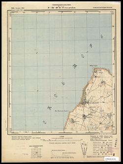
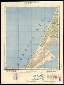
-
- Subject:
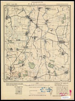
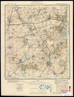
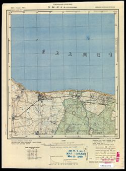
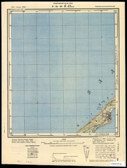
- Geographic Subject: Nekrasovo, Topical Subject: Maps, and Topical Subject: Soviet Union
- Publisher:
- Генеральный штаб РККА
- Language:
- Russian
- Date Created:
- 1940
- Identifier:
- VAC9619-003658
- Genre:
- Topographic Maps and Military Maps
- Geographic Location:
- Coordinates: 54.833, 20.625, 54.913, 20.75
- Related URL:
- Download GeoTIFF: https://drive.google.com/file/d/1MGbTDmHb75YR7HS57hiV30Aj6paADZub/view?usp=sharing and Catalog URL: https://iucat.iu.edu/catalog/14701157
- Abstract:
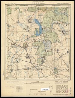
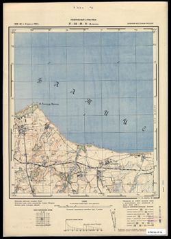
- Modern area represented: Некрасово (Nekrasovo), Kaliningradskaya oblast, Russia
- Call Number:
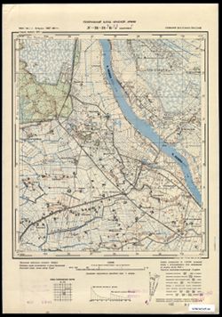
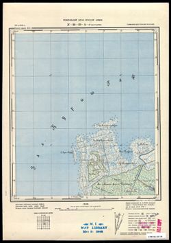
- G7063.K2 s25 .S6 sheet N-34-42-A-d
- City:
- Лиска Шаакен (Liska-Shaaken)
- Copyright Holder:
- No Copyright - United States
- Country:
- Германия (Восточная Пруссия) (Germany (East Prussia))
- Physical Description:
- Scale: 1:25,000
- Persistent URL:
- http://purl.dlib.indiana.edu/iudl/images/VAC9619/VAC9619-003658
- Provenance:
- M. I. Map Library
-

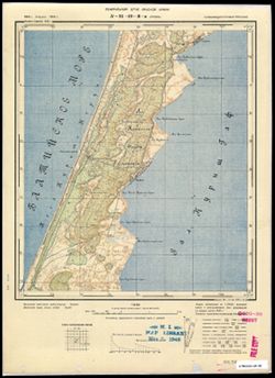
- Subject:
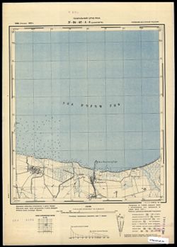
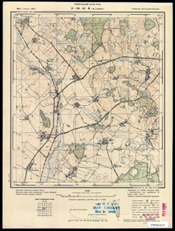
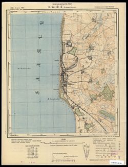
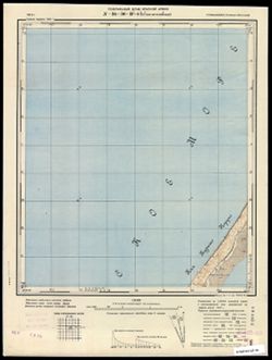
- Topical Subject: Maps, Topical Subject: Soviet Union, and Geographic Subject: Khrabrovo
- Publisher:
- Генеральный штаб РККА
- Language:
- Russian
- Date Created:
- 1940
- Identifier:
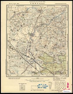
- VAC9619-003657
- Genre:
- Topographic Maps and Military Maps
- Geographic Location:
- Coordinates: 54.833, 20.5, 54.913, 20.625
- Related URL:
- Catalog URL: https://iucat.iu.edu/catalog/14701157 and Download GeoTIFF: https://drive.google.com/file/d/1wSq1TJeWhsPN4AeDydZXwn7_D6cT_4qK/view?usp=sharing
- Abstract:
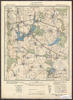
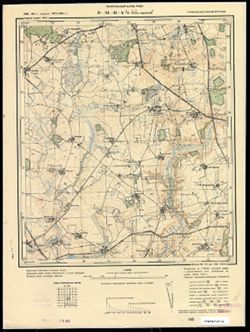
- Modern area represented: Храброво (Khrabrovo), Kaliningradskaya oblast, Russia
- Call Number:
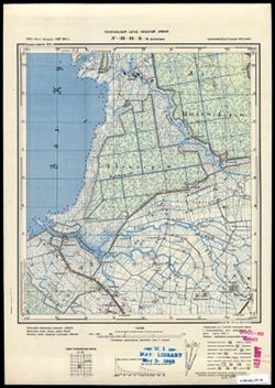
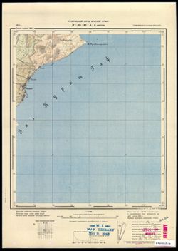
- G7063.K2 s25 .S6 sheet N-34-42-A-c
- City:
- Повунден (Powunden)
- Copyright Holder:
- No Copyright - United States
- Country:
- Германия (Восточная Пруссия) (Germany (East Prussia))
- Physical Description:
- Scale: 1:25,000
- Persistent URL:
- http://purl.dlib.indiana.edu/iudl/images/VAC9619/VAC9619-003657
- Provenance:
- M. I. Map Library
-
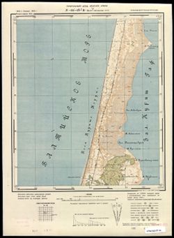
- Subject:
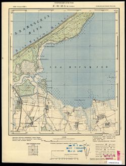
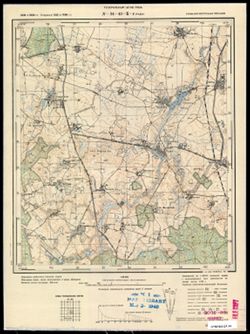
- Topical Subject: Soviet Union, Topical Subject: Maps, and Geographic Subject: Kashirskoye
- Publisher:
- Генеральный штаб РККА
- Language:
- Russian
- Date Created:
- 1940
- Identifier:
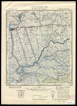
- VAC9619-003656
- Genre:
- Topographic Maps and Military Maps
- Geographic Location:
- Coordinates: 54.913, 20.625, 55, 20.75
- Related URL:
- Download GeoTIFF: https://drive.google.com/file/d/1Im9AnczT-6LGBjCUKV6iTJa5LgmB8Hg7/view?usp=sharing and Catalog URL: https://iucat.iu.edu/catalog/14701157
- Abstract:
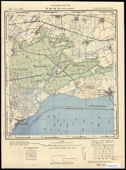
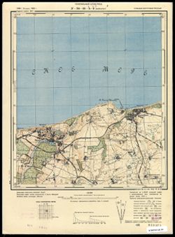
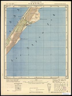
- Modern area represented: Каширское (Kashirskoye), Kaliningradskaya oblast, Russia
- Call Number:
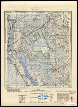
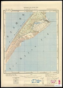
- G7063.K2 s25 .S6 sheet N-34-42-A-b
- City:
- Шааксвите (Schaakswitte)
- Copyright Holder:
- No Copyright - United States
- Country:
- Германия (Восточная Пруссия) (Germany (East Prussia))
- Physical Description:
- Scale: 1:25,000
- Persistent URL:
- http://purl.dlib.indiana.edu/iudl/images/VAC9619/VAC9619-003656
- Provenance:
- CIA Map Branch -- Received
-
- Subject:
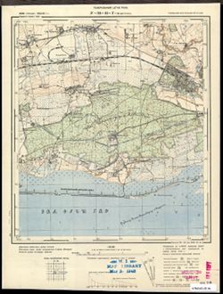
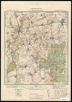
- Topical Subject: Maps, Geographic Subject: Sosnovka, and Topical Subject: Soviet Union
- Publisher:
- Генеральный штаб РККА
- Language:
- Russian
- Date Created:
- 1940
- Identifier:
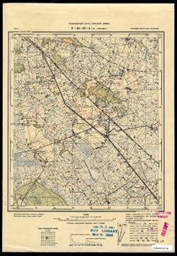
- VAC9619-003655
- Genre:
- Topographic Maps and Military Maps
- Geographic Location:
- Coordinates: 54.913, 20.5, 55, 20.625
- Related URL:
- Download GeoTIFF: https://drive.google.com/file/d/1UX9Y1lBzSE1zpYf770mAiH2euyoXxO6f/view?usp=sharing and Catalog URL: https://iucat.iu.edu/catalog/14701157
- Abstract:
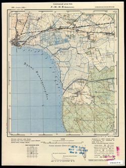
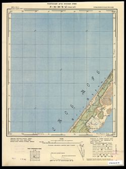
- Modern area represented: Сосновка (Sosnovka), Kaliningradskaya oblast, Russia
- Call Number:
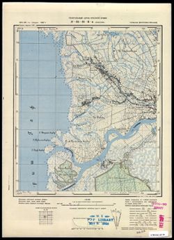
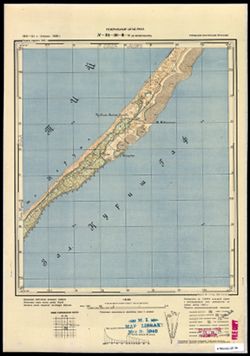
- G7063.K2 s25 .S6 sheet N-34-42-A-a
- City:
- Бледау (Bledau)
- Copyright Holder:
- No Copyright - United States
- Country:
- Германия (Восточная Пруссия) (Germany (East Prussia))
- Physical Description:
- Scale: 1:25,000
- Persistent URL:
- http://purl.dlib.indiana.edu/iudl/images/VAC9619/VAC9619-003655
- Provenance:
- M. I. Map Library
-
- Subject:
- Topical Subject: Soviet Union, Geographic Subject: Aleksandra Kosmodem’yanskogo, and Topical Subject: Maps
- Publisher:
- Генеральный штаб РККА
- Language:
- Russian
- Date Created:
- 1940
- Identifier:
- VAC9619-003654
- Genre:
- Topographic Maps and Military Maps
- Geographic Location:
- Coordinates: 54.667, 20.25, 54.75, 20.375
- Related URL:
- Catalog URL: https://iucat.iu.edu/catalog/14701157 and Download GeoTIFF: https://drive.google.com/file/d/193K35AFpNdsmNuzDzsY9x3iaQ82U50mL/view?usp=sharing
- Abstract:
- Modern area represented: Александра Космодемьянского (Aleksandra Kosmodem’yanskogo), Kaliningradskaya oblast, Russia
- Call Number:
- G7063.K2 s25 .S6 sheet N-34-41-D-c
- City:
- Метгетен (Metgethen)
- Copyright Holder:
- No Copyright - United States
- Country:
- Германия (Восточная Пруссия) (Germany (East Prussia))
- Physical Description:
- Scale: 1:25,000
- Persistent URL:
- http://purl.dlib.indiana.edu/iudl/images/VAC9619/VAC9619-003654
- Provenance:
- M. I. Map Library
-
- Subject:
- Topical Subject: Soviet Union, Topical Subject: Maps, and Geographic Subject: Dorozhnyy
- Publisher:
- Генеральный штаб РККА
- Language:
- Russian
- Date Created:
- 1940
- Identifier:
- VAC9619-003653
- Genre:
- Military Maps and Topographic Maps
- Geographic Location:
- Coordinates: 54.75, 20.375, 54.833, 20.5
- Related URL:
- Download GeoTIFF: https://drive.google.com/file/d/1O9LWLzbW4TC8Jmx1-arl8hWMH0L5TBPK/view?usp=sharing and Catalog URL: https://iucat.iu.edu/catalog/14701157
- Abstract:
- Modern area represented: Дорожный (Dorozhnyy), Kaliningradskaya oblast, Russia
- Call Number:
- G7063.K2 s25 .S6 sheet N-34-41-D-b
- City:
- Нойхоф (Neuhof)
- Copyright Holder:
- No Copyright - United States
- Country:
- Германия (Восточная Пруссия) (Germany (East Prussia))
- Physical Description:
- Scale: 1:25,000
- Persistent URL:
- http://purl.dlib.indiana.edu/iudl/images/VAC9619/VAC9619-003653
- Provenance:
- CIA Map Branch -- Received
-
- Subject:
- Geographic Subject: Pereslavskoye, Topical Subject: Soviet Union, and Topical Subject: Maps
- Publisher:
- Генеральный штаб РККА
- Language:
- Russian
- Date Created:
- 1940
- Identifier:
- VAC9619-003652
- Genre:
- Military Maps and Topographic Maps
- Geographic Location:
- Coordinates: 54.75, 20.25, 54.833, 20.375
- Related URL:
- Download GeoTIFF: https://drive.google.com/file/d/1LfaWmL2ijvkDtgRW4XQtS_4nFJIghbiH/view?usp=sharing and Catalog URL: https://iucat.iu.edu/catalog/14701157
- Abstract:
- Modern area represented: Переславское (Pereslavskoye), Kaliningradskaya oblast, Russia
- Call Number:
- G7063.K2 s25 .S6 sheet N-34-41-D-a
- City:
- Другенен (Drugenen)
- Copyright Holder:
- No Copyright - United States
- Country:
- Германия (Восточная Пруссия) (Germany (East Prussia))
- Physical Description:
- Scale: 1:25,000
- Persistent URL:
- http://purl.dlib.indiana.edu/iudl/images/VAC9619/VAC9619-003652
- Provenance:
- CIA Map Branch -- Received
-
- Subject:
- Topical Subject: Soviet Union, Geographic Subject: Vzmor'ye, and Topical Subject: Maps
- Publisher:
- Генеральный штаб РККА
- Language:
- Russian
- Date Created:
- 1940
- Identifier:
- VAC9619-003651
- Genre:
- Topographic Maps and Military Maps
- Geographic Location:
- Coordinates: 54.667, 20.125, 54.75, 20.25
- Related URL:
- Download GeoTIFF: https://drive.google.com/file/d/1ruA4NnmT5iyE_wOjoTTiyhdKfrmcu36X/view?usp=sharing and Catalog URL: https://iucat.iu.edu/catalog/14701157
- Abstract:
- Modern area represented: Взморье (Vzmor'ye), Kaliningradskaya oblast, Russia
- Call Number:
- G7063.K2 s25 .S6 sheet N-34-41-C-d
- City:
- Гросс Хайдекруг (Gross-Heydekrug)
- Copyright Holder:
- No Copyright - United States
- Country:
- Германия (Восточная Пруссия) (Germany (East Prussia))
- Physical Description:
- Scale: 1:25,000
- Persistent URL:
- http://purl.dlib.indiana.edu/iudl/images/VAC9619/VAC9619-003651
- Provenance:
- CIA Map Branch -- Received
-
- Subject:
- Topical Subject: Maps, Geographic Subject: Primorsk, and Topical Subject: Soviet Union
- Publisher:
- Генеральный штаб РККА
- Language:
- Russian
- Date Created:
- 1940
- Identifier:
- VAC9619-003650
- Genre:
- Topographic Maps and Military Maps
- Geographic Location:
- Coordinates: 54.667, 20, 54.75, 20.125
- Related URL:
- Catalog URL: https://iucat.iu.edu/catalog/14701157 and Download GeoTIFF: https://drive.google.com/file/d/1ZaPxpSH_R9Waq5KuOD2xRLk2raxVJEgC/view?usp=sharing
- Abstract:
- Modern area represented: Приморск (Primorsk), Kaliningradskaya oblast, Russia
- Call Number:
- G7063.K2 s25 .S6 sheet N-34-41-C-c
- City:
- Фишхаузен (Fischhausen)
- Copyright Holder:
- No Copyright - United States
- Country:
- Германия (Восточная Пруссия) (Germany (East Prussia))
- Physical Description:
- Scale: 1:25,000
- Persistent URL:
- http://purl.dlib.indiana.edu/iudl/images/VAC9619/VAC9619-003650
- Provenance:
- M. I. Map Library
-
- Subject:
- Geographic Subject: Logvino, Topical Subject: Soviet Union, and Topical Subject: Maps
- Publisher:
- Генеральный штаб РККА
- Language:
- Russian
- Date Created:
- 1940
- Identifier:
- VAC9619-003649
- Genre:
- Military Maps and Topographic Maps
- Geographic Location:
- Coordinates: 54.75, 20.125, 54.833, 20.25
- Related URL:
- Catalog URL: https://iucat.iu.edu/catalog/14701157 and Download GeoTIFF: https://drive.google.com/file/d/12OQeiAz__vleYTE7RvBg_NYIOGYf9Qhg/view?usp=sharing
- Abstract:
- Modern area represented: Логвино (Logvino), Kaliningradskaya oblast, Russia
- Call Number:
- G7063.K2 s25 .S6 sheet N-34-41-C-b
- City:
- Меденау (Medenau)
- Copyright Holder:
- No Copyright - United States
- Country:
- Германия (Восточная Пруссия) (Germany (East Prussia))
- Physical Description:
- Scale: 1:25,000
- Persistent URL:
- http://purl.dlib.indiana.edu/iudl/images/VAC9619/VAC9619-003649
- Provenance:
- M. I. Map Library
-
- Subject:
- Geographic Subject: Parusnoye, Topical Subject: Maps, and Topical Subject: Soviet Union
- Publisher:
- Генеральный штаб РККА
- Language:
- Russian
- Date Created:
- 1940
- Identifier:
- VAC9619-003648
- Genre:
- Military Maps and Topographic Maps
- Geographic Location:
- Coordinates: 54.75, 20, 54.833, 20.125
- Related URL:
- Download GeoTIFF: https://drive.google.com/file/d/1E7qWpB33gIGJ7jYIXXLsAn5GpDiK_nG9/view?usp=sharing and Catalog URL: https://iucat.iu.edu/catalog/14701157
- Abstract:
- Modern area represented: Парусное (Parusnoye), Kaliningradskaya oblast, Russia
- Call Number:
- G7063.K2 s25 .S6 sheet N-34-41-C-a
- City:
- Гаффкен (Gaffken)
- Copyright Holder:
- No Copyright - United States
- Country:
- Германия (Восточная Пруссия) (Germany (East Prussia))
- Physical Description:
- Scale: 1:25,000
- Persistent URL:
- http://purl.dlib.indiana.edu/iudl/images/VAC9619/VAC9619-003648
- Provenance:
- M. I. Map Library
-
- Subject:
- Geographic Subject: Mel’nikovo, Topical Subject: Soviet Union, and Topical Subject: Maps
- Publisher:
- Генеральный штаб РККА
- Language:
- Russian
- Date Created:
- 1940
- Identifier:
- VAC9619-003647
- Genre:
- Military Maps and Topographic Maps
- Geographic Location:
- Coordinates: 54.833, 20.375, 54.913, 20.5
- Related URL:
- Download GeoTIFF: https://drive.google.com/file/d/1ajWxPW6SILzy7kmX1R-tGPfH470kaeN_/view?usp=sharing and Catalog URL: https://iucat.iu.edu/catalog/14701157
- Abstract:
- Modern area represented: Мельниково (Mel’nikovo), Kaliningradskaya oblast, Russia
- Call Number:
- G7063.K2 s25 .S6 sheet N-34-41-B-d
- City:
- Рудау (Рудау)
- Copyright Holder:
- No Copyright - United States
- Country:
- Германия (Восточная Пруссия) (Germany (East Prussia))
- Physical Description:
- Scale: 1:25,000
- Persistent URL:
- http://purl.dlib.indiana.edu/iudl/images/VAC9619/VAC9619-003647
- Provenance:
- M. I. Map Library
-
- Subject:
- Geographic Subject: Romanovo, Topical Subject: Soviet Union, and Topical Subject: Maps
- Publisher:
- Генеральный штаб РККА
- Language:
- Russian
- Date Created:
- 1940
- Identifier:
- VAC9619-003646
- Genre:
- Topographic Maps and Military Maps
- Geographic Location:
- Coordinates: 54.833, 20.25, 54.913, 20.375
- Related URL:
- Download GeoTIFF: https://drive.google.com/file/d/1pG2MBjIwl3kfUiuEHwPdXIGFiepfZO5p/view?usp=sharing and Catalog URL: https://iucat.iu.edu/catalog/14701157
- Abstract:
- Modern area represented: Романово (Romanovo), Kaliningradskaya oblast, Russia
- Call Number:
- G7063.K2 s25 .S6 sheet N-34-41-B-c
- City:
- Побетен (Pobeten)
- Copyright Holder:
- No Copyright - United States
- Country:
- Германия (Восточная Пруссия) (Germany (East Prussia))
- Physical Description:
- Scale: 1:25,000
- Persistent URL:
- http://purl.dlib.indiana.edu/iudl/images/VAC9619/VAC9619-003646
- Provenance:
- CIA Map Branch -- Received
-
- Subject:
- Geographic Subject: Zaostrov’ye, Topical Subject: Soviet Union, and Topical Subject: Maps
- Publisher:
- Генеральный штаб РККА
- Language:
- Russian
- Date Created:
- 1940
- Identifier:
- VAC9619-003644
- Genre:
- Military Maps and Topographic Maps
- Geographic Location:
- Coordinates: 54.913, 20.25, 55, 20.375
- Related URL:
- Download GeoTIFF: https://drive.google.com/file/d/1_Rfi01p_uZbHxyLfwbvN0caeO3xUwMzh/view?usp=sharing and Catalog URL: https://iucat.iu.edu/catalog/14701157
- Abstract:
- Modern area represented: Заостровье (Zaostrov’ye), Kaliningradskaya oblast, Russia
- Call Number:
- G7063.K2 s25 .S6 sheet N-34-41-B-a
- City:
- Рантау (Rantau)
- Copyright Holder:
- No Copyright - United States
- Country:
- Германия (Восточная Пруссия) (Germany (East Prussia))
- Physical Description:
- Scale: 1:25,000
- Persistent URL:
- http://purl.dlib.indiana.edu/iudl/images/VAC9619/VAC9619-003644
- Provenance:
- CIA Map Branch -- Received
-
- Subject:
- Geographic Subject: Urochishche Yasnovka, Topical Subject: Maps, and Topical Subject: Soviet Union
- Publisher:
- Генеральный штаб РККА
- Language:
- Russian
- Date Created:
- 1940
- Identifier:
- VAC9619-003643
- Genre:
- Topographic Maps and Military Maps
- Geographic Location:
- Coordinates: 54.833, 20.125, 54.913, 20.25
- Related URL:
- Download GeoTIFF: https://drive.google.com/file/d/15fKiI5C-ivmpkcJn3339tIWghSYUqeln/view?usp=sharing and Catalog URL: https://iucat.iu.edu/catalog/14701157
- Abstract:
- Modern area represented: Урочище Ясновка (Urochishche Yasnovka), Kaliningradskaya oblast, Russia
- Call Number:
- G7063.K2 s25 .S6 sheet N-34-41-A-d
- City:
- Гросс Лядткайм (Gross Lyadtkaym)
- Copyright Holder:
- No Copyright - United States
- Country:
- Германия (Восточная Пруссия) (Germany (East Prussia))
- Physical Description:
- Scale: 1:25,000
- Persistent URL:
- http://purl.dlib.indiana.edu/iudl/images/VAC9619/VAC9619-003643
- Provenance:
- CIA Map Branch -- Received
-
- Subject:
- Topical Subject: Soviet Union, Topical Subject: Maps, and Geographic Subject: Russkoye
- Publisher:
- Генеральный штаб РККА
- Language:
- Russian
- Date Created:
- 1940
- Identifier:
- VAC9619-003642
- Genre:
- Topographic Maps and Military Maps
- Geographic Location:
- Coordinates: 54.833, 20, 54.913, 20.125
- Related URL:
- Catalog URL: https://iucat.iu.edu/catalog/14701157 and Download GeoTIFF: https://drive.google.com/file/d/1VSSF7XSIhoqBE57vgJGRWH9RFFpiQ7nb/view?usp=sharing
- Abstract:
- Modern area represented: Русское (Russkoye), Kaliningradskaya oblast, Russia
- Call Number:
- G7063.K2 s25 .S6 sheet N-34-41-A-c
- City:
- Гермау (Germau)
- Copyright Holder:
- No Copyright - United States
- Country:
- Германия (Восточная Пруссия) (Germany (East Prussia))
- Physical Description:
- Scale: 1:25,000
- Persistent URL:
- http://purl.dlib.indiana.edu/iudl/images/VAC9619/VAC9619-003642
- Provenance:
- Army Map Service Library, OMAHA, Library of Congress Geography & Map Division
-
- Description:
- 1908
- Subject:
- Topical Subject: Maps, Topical Subject: Soviet Union, and Geographic Subject: Pionerskiy
- Publisher:
- Генеральный штаб РККА
- Language:
- Russian
- Date Created:
- 1940
- Identifier:
- VAC9619-003641
- Genre:
- Military Maps and Topographic Maps
- Geographic Location:
- Coordinates: 54.917, 20.125, 55, 20.25
- Related URL:
- Download GeoTIFF: https://drive.google.com/file/d/1SwmYdFIcLuUzTtx9HSU8IIpW0wMPOpjh/view?usp=sharing and Catalog URL: https://iucat.iu.edu/catalog/14701157
- Abstract:
- Modern area represented: Пионерский (Pionerskiy), Kaliningradskaya oblast, Russia
- Call Number:
- G7063.K2 s25 .S6 sheet N-34-41-A-b
- City:
- Нойкурен (Neukuhren)
- Copyright Holder:
- No Copyright - United States
- Country:
- Германия (Восточная Пруссия) (Germany (East Prussia))
- Physical Description:
- Scale: 1:25,000
- Persistent URL:
- http://purl.dlib.indiana.edu/iudl/images/VAC9619/VAC9619-003641
- Provenance:
- CIA Map Branch -- Received
-
- Subject:
- Geographic Subject: Otradnoye, Topical Subject: Maps, and Topical Subject: Soviet Union
- Publisher:
- Генеральный штаб РККА
- Language:
- Russian
- Date Created:
- 1940
- Identifier:
- VAC9619-003640
- Genre:
- Military Maps and Topographic Maps
- Geographic Location:
- Coordinates: 54.917, 20, 55, 20.125
- Related URL:
- Download GeoTIFF: https://drive.google.com/file/d/1wBta6TPrRnZLX7ONX6TLEBrEjrovggKO/view?usp=sharing and Catalog URL: https://iucat.iu.edu/catalog/14701157
- Abstract:
- Modern area represented: Отрадное (Otradnoye), Kaliningradskaya oblast, Russia
- Call Number:
- G7063.K2 s25 .S6 sheet N-34-41-A-а
- City:
- Георгенсвальде (Georgenswalde)
- Copyright Holder:
- No Copyright - United States
- Country:
- Германия (Восточная Пруссия) (Germany (East Prussia))
- Physical Description:
- Scale: 1:25,000
- Persistent URL:
- http://purl.dlib.indiana.edu/iudl/images/VAC9619/VAC9619-003640
- Provenance:
- M. I. Map Library
-
- Subject:
- Geographic Subject: Mechnikov, Topical Subject: Maps, and Topical Subject: Soviet Union
- Publisher:
- Генеральный штаб РККА
- Language:
- Russian
- Date Created:
- 1940
- Identifier:
- VAC9619-003639
- Genre:
- Military Maps and Topographic Maps
- Geographic Location:
- Coordinates: 54.667, 19.875, 54.75, 20
- Related URL:
- Catalog URL: https://iucat.iu.edu/catalog/14701157 and Download GeoTIFF: https://drive.google.com/file/d/1qmu3bPyfFDSAJy-L6UJx3ttRnxj3oi-3/view?usp=sharing
- Abstract:
- Modern area represented: Мечников (Mechnikov), Kaliningradskaya oblast, Russia
- Call Number:
- G7063.K2 s25 .S6 sheet N-34-40-D-d
- City:
- Нойхойзер (Neuhäuser)
- Copyright Holder:
- No Copyright - United States
- Country:
- Германия (Восточная Пруссия) (Germany (East Prussia))
- Physical Description:
- Scale: 1:25,000
- Persistent URL:
- http://purl.dlib.indiana.edu/iudl/images/VAC9619/VAC9619-003639
- Provenance:
- Army Map Service Library, OMAHA, Library of Congress Geography & Map Division
-
- Subject:
- Topical Subject: Soviet Union, Geographic Subject: Urochishche Rakitino, and Topical Subject: Maps
- Publisher:
- Генеральный штаб РККА
- Language:
- Russian
- Date Created:
- 1940
- Identifier:
- VAC9619-003638
- Genre:
- Topographic Maps and Military Maps
- Geographic Location:
- Coordinates: 54.75, 19.875, 54.833, 20
- Related URL:
- Catalog URL: https://iucat.iu.edu/catalog/14701157 and Download GeoTIFF: https://drive.google.com/file/d/1FEk7tYmp_00J8YHN6z2jA8d3qQ8A9xzA/view?usp=sharing
- Abstract:
- Modern area represented: Урочище Ракитино (Urochishche Rakitino), Kaliningradskaya oblast, Russia
- Call Number:
- G7063.K2 s25 .S6 sheet N-34-40-D-b
- City:
- Ротенен (Rothenen)
- Copyright Holder:
- No Copyright - United States
- Country:
- Германия (Восточная Пруссия) (Germany (East Prussia))
- Physical Description:
- Scale: 1:25,000
- Persistent URL:
- http://purl.dlib.indiana.edu/iudl/images/VAC9619/VAC9619-003638
- Provenance:
- Army Map Service Library, OMAHA, Library of Congress Geography & Map Division
-
- Subject:
- Topical Subject: Maps, Geographic Subject: Jantarnyj, and Topical Subject: Soviet Union
- Publisher:
- Генеральный штаб РККА
- Language:
- Russian
- Date Created:
- 1940
- Identifier:
- VAC9619-003637
- Genre:
- Military Maps and Topographic Maps
- Geographic Location:
- Coordinates: 54.833, 19.875, 54.917, 20
- Related URL:
- Download GeoTIFF: https://drive.google.com/file/d/1e9F6YSPWMO03ATpPj5mzzwMl34SommdS/view?usp=sharing and Catalog URL: https://iucat.iu.edu/catalog/14701157
- Abstract:
- Modern area represented: Янтарный (Jantarnyj), Kaliningradskaya oblast, Russia
- Call Number:
- G7063.K2 s25 .S6 sheet N-34-40-B-d
- City:
- Кракстепеллен (Kraxtepellen)
- Copyright Holder:
- No Copyright - United States
- Country:
- Германия (Восточная Пруссия) (Germany (East Prussia))
- Physical Description:
- Scale: 1:25,000
- Persistent URL:
- http://purl.dlib.indiana.edu/iudl/images/VAC9619/VAC9619-003637
- Provenance:
- CIA Map Branch -- Received
-
- Subject:
- Topical Subject: Maps, Geographic Subject: Donskoye, and Topical Subject: Soviet Union
- Publisher:
- Генеральный штаб РККА
- Language:
- Russian
- Date Created:
- 1940
- Identifier:
- VAC9619-003636
- Genre:
- Topographic Maps and Military Maps
- Geographic Location:
- Coordinates: 54.917, 19.875, 55, 20
- Related URL:
- Catalog URL: https://iucat.iu.edu/catalog/14701157 and Download GeoTIFF: https://drive.google.com/file/d/10LUWuO7qK1I4WXJrqzCbHutrdyUuSgZM/view?usp=sharing
- Abstract:
- Modern area represented: Донское (Donskoye), Kaliningradskaya oblast, Russia
- Call Number:
- G7063.K2 s25 .S6 sheet N-34-40-B-b
- City:
- Гросс Диршкайм (Gross Dirshkaym)
- Copyright Holder:
- No Copyright - United States
- Country:
- Германия (Восточная Пруссия) (Germany (East Prussia))
- Physical Description:
- Scale: 1:25,000
- Persistent URL:
- http://purl.dlib.indiana.edu/iudl/images/VAC9619/VAC9619-003636
- Provenance:
- CIA Map Branch -- Received
-
- Subject:
- Topical Subject: Soviet Union, Topical Subject: Maps, and Geographic Subject: Rugėnai
- Publisher:
- Генеральный штаб Красной Армии
- Language:
- Russian
- Date Created:
- 1940
- Identifier:
- VAC9619-003626
- Genre:
- Topographic Maps and Military Maps
- Geographic Location:
- Coordinates: 55.1667, 23.625, 55.25, 23.75
- Related URL:
- Catalog URL: https://iucat.iu.edu/catalog/14701157 and Download GeoTIFF: https://drive.google.com/file/d/17B7GRYPqAsYzQVoyLT1DzMceCqi0OZtz/view?usp=sharing
- Abstract:
- Modern area represented: Rugėnai, Lithuania
- Call Number:
- G7063.K2 s25 .S6 sheet N-34-36-A-d
- Caption:
- Секретно
- City:
- Ругяны (Rugyany)
- Copyright Holder:
- No Copyright - United States
- Country:
- СССР (USSR)
- State/Province:
- Литовская ССР (Lithuanian Soviet Socialist Republic)
- Physical Description:
- Scale: 1:25,000
- Persistent URL:
- http://purl.dlib.indiana.edu/iudl/images/VAC9619/VAC9619-003626
- Provenance:
- Army Map Service Library, OMAHA, Library of Congress Geography & Map Division
-
- Subject:
- Geographic Subject: Gastellovo, Topical Subject: Maps, and Topical Subject: Soviet Union
- Publisher:
- Генеральный штаб Красной Армии
- Language:
- Russian
- Date Created:
- 1940
- Identifier:
- VAC9619-003608
- Genre:
- Military Maps and Topographic Maps
- Geographic Location:
- Coordinates: 55, 21.5, 55.083, 21.625
- Related URL:
- Download GeoTIFF: https://drive.google.com/file/d/1MZqo3Hsc5RDE9S6gTO-v8LULaYz-h7eG/view?usp=sharing and Catalog URL: https://iucat.iu.edu/catalog/14701157
- Abstract:
- Modern area represented: Гастеллово (Gastellovo), Kaliningradskaya oblast, Russia
- Call Number:
- G7063.K2 s25 .S6 sheet N-34-32-C-c
- City:
- Гросс Фридрихсдорф (Gross-Friedrichsdorf)
- Copyright Holder:
- No Copyright - United States
- Country:
- Германия (Восточная Пруссия) (Germany (East Prussia))
- Physical Description:
- Scale: 1:25,000
- Persistent URL:
- http://purl.dlib.indiana.edu/iudl/images/VAC9619/VAC9619-003608
- Provenance:
- M. I. Map Library
-
- Description:
- 1914
- Subject:
- Geographic Subject: Leninskoye, Topical Subject: Soviet Union, and Topical Subject: Maps
- Publisher:
- Генеральный штаб Красной Армии
- Language:
- Russian
- Date Created:
- 1940
- Identifier:
- VAC9619-003607
- Genre:
- Military Maps and Topographic Maps
- Geographic Location:
- Coordinates: 55.083, 21.625, 55.167, 21.75
- Related URL:
- Catalog URL: https://iucat.iu.edu/catalog/14701157 and Download GeoTIFF: https://drive.google.com/file/d/1j51PFng0UaZNVB4RJ-jG-m1SVLImG4T8/view?usp=sharing
- Abstract:
- Modern area represented: Ленинское (Leninskoye), Kaliningradskaya oblast, Russia
- Call Number:
- G7063.K2 s25 .S6 sheet N-34-32-C-b
- City:
- Покранен (Pokranen)
- Copyright Holder:
- No Copyright - United States
- Country:
- Германия (Восточная Пруссия) (Germany (East Prussia))
- Physical Description:
- Scale: 1:25,000
- Persistent URL:
- http://purl.dlib.indiana.edu/iudl/images/VAC9619/VAC9619-003607
- Provenance:
- M. I. Map Library
-
- Subject:
- Topical Subject: Maps, Geographic Subject: Timiryazevo, and Topical Subject: Soviet Union
- Publisher:
- Генеральный штаб Красной Армии
- Language:
- Russian
- Date Created:
- 1940
- Identifier:
- VAC9619-003606
- Genre:
- Military Maps and Topographic Maps
- Geographic Location:
- Coordinates: 55.083, 21.5, 55.167, 21.625
- Related URL:
- Download GeoTIFF: https://drive.google.com/file/d/1A4tphk51ZC2_5trvDLsj3bxhTOvIkMKD/view?usp=sharing and Catalog URL: https://iucat.iu.edu/catalog/14701157
- Abstract:
- Modern area represented: Тимирязево (Timiryazevo), Kaliningradskaya oblast, Russia
- Call Number:
- G7063.K2 s25 .S6 sheet N-34-32-C-a
- City:
- Нойкирх (Neukirch)
- Copyright Holder:
- No Copyright - United States
- Country:
- Германия (Восточная Пруссия) (Germany (East Prussia))
- Physical Description:
- Scale: 1:25,000
- Persistent URL:
- http://purl.dlib.indiana.edu/iudl/images/VAC9619/VAC9619-003606
- Provenance:
- M. I. Map Library, Library of Congress Geography & Map Division
-
- Subject:
- Topical Subject: Soviet Union, Topical Subject: Maps, and Geographic Subject: Stoniškiai
- Publisher:
- Генеральный штаб Красной Армии
- Language:
- Russian
- Date Created:
- 1940
- Identifier:
- VAC9619-003605
- Genre:
- Military Maps and Topographic Maps
- Geographic Location:
- Coordinates: 55.167, 21.75, 55.25, 21.875
- Related URL:
- Catalog URL: https://iucat.iu.edu/catalog/14701157 and Download GeoTIFF: https://drive.google.com/file/d/18tsNi3lGYr3QkOTeUG0haO250w1AnaYA/view?usp=sharing
- Abstract:
- Modern area represented: Stoniškiai, Lithuania
- Call Number:
- G7063.K2 s25 .S6 sheet N-34-32-B-c
- City:
- Штонишкен (Stonischken)
- Copyright Holder:
- No Copyright - United States
- Country:
- Германия (Восточная Пруссия) (Germany (East Prussia))
- Physical Description:
- Scale: 1:25,000
- Persistent URL:
- http://purl.dlib.indiana.edu/iudl/images/VAC9619/VAC9619-003605
- Provenance:
- M. I. Map Library
-
- Subject:
- Topical Subject: Maps, Geographic Subject: Zapovednoye, and Topical Subject: Soviet Union
- Publisher:
- Генеральный штаб Красной Армии
- Language:
- Russian
- Date Created:
- 1940
- Identifier:
- VAC9619-003601
- Genre:
- Topographic Maps and Military Maps
- Geographic Location:
- Coordinates: 55, 21.375, 55.083, 21.5
- Related URL:
- Catalog URL: https://iucat.iu.edu/catalog/14701157 and Download GeoTIFF: https://drive.google.com/file/d/1uWl3M4zomjvWzOFer3t5m-O91SNgcmJO/view?usp=sharing
- Abstract:
- Modern area represented: Заповедное (Zapovednoye), Kaliningradskaya oblast, Russia
- Call Number:
- G7063.K2 s25 .S6 sheet N-34-31-D-d
- City:
- Зекенбург (Zekenburg)
- Copyright Holder:
- No Copyright - United States
- Country:
- Германия (Восточная Пруссия) (Germany (East Prussia))
- Physical Description:
- Scale: 1:25,000
- Persistent URL:
- http://purl.dlib.indiana.edu/iudl/images/VAC9619/VAC9619-003601
- Provenance:
- CIA Map Branch -- Received
-
- Description:
- 1912
- Subject:
- Topical Subject: Maps, Topical Subject: Soviet Union, and Geographic Subject: Juknaičiai
- Publisher:
- Генеральный штаб Красной Армии
- Language:
- Russian
- Date Created:
- 1940
- Identifier:
- VAC9619-003602
- Genre:
- Topographic Maps and Military Maps
- Geographic Location:
- Coordinates: 55.25, 21.5, 55.333, 21.625
- Related URL:
- Catalog URL: https://iucat.iu.edu/catalog/14701157 and Download GeoTIFF: https://drive.google.com/file/d/1ihu5UIGhlU3arCwjYStCbKR3_9DdTMje/view?usp=sharing
- Abstract:
- Modern area represented: part of Juknaičiai (?), Lithuania
- Call Number:
- G7063.K2 s25 .S6 sheet N-34-32-A-a
- City:
- Бляузден (Blyauzden)
- Copyright Holder:
- No Copyright - United States
- Country:
- Германия (Восточная Пруссия) (Germany (East Prussia))
- Physical Description:
- Scale: 1:25,000
- Persistent URL:
- http://purl.dlib.indiana.edu/iudl/images/VAC9619/VAC9619-003602
- Provenance:
- M. I. Map Library
-
- Subject:
- Topical Subject: Soviet Union, Geographic Subject: Bol’shiye Berezhki, and Topical Subject: Maps
- Publisher:
- Генеральный штаб Красной Армии
- Language:
- Russian
- Date Created:
- 1940
- Identifier:
- VAC9619-003600
- Genre:
- Topographic Maps and Military Maps
- Geographic Location:
- Coordinates: 55.083, 21.375, 55.167, 21.5
- Related URL:
- Download GeoTIFF: https://drive.google.com/file/d/1Xs43niWnmymd55tnrGzKRKBIheFHIdqO/view?usp=sharing and Catalog URL: https://iucat.iu.edu/catalog/14701157
- Abstract:
- Modern area represented: Большие Бережки (Bol’shiye Berezhki), Kaliningradskaya oblast, Russia
- Call Number:
- G7063.K2 s25 .S6 sheet N-34-31-D-b
- City:
- Альт Лаппинен (Al’t Lappinen)
- Copyright Holder:
- No Copyright - United States
- Country:
- Германия (Восточная Пруссия) (Germany (East Prussia))
- Physical Description:
- Scale: 1:25,000
- Persistent URL:
- http://purl.dlib.indiana.edu/iudl/images/VAC9619/VAC9619-003600
- Provenance:
- M. I. Map Library
-
- Subject:
- Topical Subject: Soviet Union, Geographic Subject: Prokhladnoye, and Topical Subject: Maps
- Publisher:
- Генеральный штаб Красной Армии
- Language:
- Russian
- Date Created:
- 1940
- Identifier:
- VAC9619-003599
- Genre:
- Topographic Maps and Military Maps
- Geographic Location:
- Coordinates: 55.083, 21.25, 55.167, 21.375
- Related URL:
- Catalog URL: https://iucat.iu.edu/catalog/14701157 and Download GeoTIFF: https://drive.google.com/file/d/1YKY74-2xF2oLvrxWPb4HoNkvYfD7rrvV/view?usp=sharing
- Abstract:
- Modern area represented: Прохладное (Prokhladnoye), Kaliningradskaya oblast, Russia
- Call Number:
- G7063.K2 s25 .S6 sheet N-34-31-D-a
- City:
- Каллнингкен (Kallningken)
- Copyright Holder:
- No Copyright - United States
- Country:
- Германия (Восточная Пруссия) (Germany (East Prussia))
- Physical Description:
- Scale: 1:25,000
- Persistent URL:
- http://purl.dlib.indiana.edu/iudl/images/VAC9619/VAC9619-003599
- Provenance:
- M. I. Map Library
-
- Subject:
- Topical Subject: Soviet Union, Topical Subject: Maps, and Geographic Subject: Matrosovo
- Publisher:
- Генеральный штаб Красной Армии
- Language:
- Russian
- Date Created:
- 1940
- Identifier:
- VAC9619-003598
- Genre:
- Military Maps and Topographic Maps
- Geographic Location:
- Coordinates: 55, 21.125, 55.083, 21.25
- Related URL:
- Catalog URL: https://iucat.iu.edu/catalog/14701157 and Download GeoTIFF: https://drive.google.com/file/d/1rwe-_4oNUllweT_eesVHOWv3Q0E5Yzd0/view?usp=sharing
- Abstract:
- Modern area represented: Матросово (Matrosovo), Kaliningradskaya oblast, Russia
- Call Number:
- G7063.K2 s25 .S6 sheet N-34-31-C-d
- City:
- Гильге (Gil’ge)
- Copyright Holder:
- No Copyright - United States
- Country:
- Германия (Восточная Пруссия) (Germany (East Prussia))
- Physical Description:
- Scale: 1:25,000
- Persistent URL:
- http://purl.dlib.indiana.edu/iudl/images/VAC9619/VAC9619-003598
- Provenance:
- CIA Map Branch -- Received
-
- Subject:
- Topical Subject: Soviet Union and Topical Subject: Maps
- Publisher:
- Генеральный штаб Красной Армии
- Language:
- Russian
- Date Created:
- 1940
- Identifier:
- VAC9619-003597
- Genre:
- Topographic Maps and Military Maps
- Geographic Location:
- Coordinates: 55.083, 21.125, 55.167, 21.25
- Related URL:
- Catalog URL: https://iucat.iu.edu/catalog/14701157 and Download GeoTIFF: https://drive.google.com/file/d/1GeMuz8uwDX2KTJSBeHIw0XqR__da7cgu/view?usp=sharing
- Abstract:
- Modern area represented: Урочище Рыбачье (Urochishche Rybach’ye), Kaliningradskaya oblast, Russia
- Call Number:
- G7063.K2 s25 .S6 sheet N-34-31-C-b
- City:
- Лойе (Loye)
- Copyright Holder:
- No Copyright - United States
- Country:
- Германия (Восточная Пруссия) (Germany (East Prussia))
- Physical Description:
- Scale: 1:25,000
- Persistent URL:
- http://purl.dlib.indiana.edu/iudl/images/VAC9619/VAC9619-003597
- Provenance:
- CIA Map Branch -- Received
-
- Subject:
- Topical Subject: Soviet Union, Topical Subject: Maps, and Geographic Subject: Levoberezhnoye
- Publisher:
- Генеральный штаб Красной Армии
- Language:
- Russian
- Date Created:
- 1940
- Identifier:
- VAC9619-003596
- Genre:
- Military Maps and Topographic Maps
- Geographic Location:
- Coordinates: 55.167, 21.375, 55.25, 21.5
- Related URL:
- Download GeoTIFF: https://drive.google.com/file/d/1dvlY0f2u3s9DuxAwvSM6kSiwi08WRsQD/view?usp=sharing and Catalog URL: https://iucat.iu.edu/catalog/14701157
- Abstract:
- Modern area represented: Левобережное (Levoberezhnoye), Kaliningradskaya oblast, Russia
- Call Number:
- G7063.K2 s25 .S6 sheet N-34-31-B-d
- City:
- Шакунен (Shakunen)
- Copyright Holder:
- No Copyright - United States
- Country:
- Германия (Восточная Пруссия) (Germany (East Prussia))
- Physical Description:
- Scale: 1:25,000
- Persistent URL:
- http://purl.dlib.indiana.edu/iudl/images/VAC9619/VAC9619-003596
- Provenance:
- CIA Map Branch -- Received
-
- Subject:
- Topical Subject: Maps, Geographic Subject: Mysovka, and Topical Subject: Soviet Union
- Publisher:
- Генеральный штаб Красной Армии
- Language:
- Russian
- Date Created:
- 1940
- Identifier:
- VAC9619-003595
- Genre:
- Topographic Maps and Military Maps
- Geographic Location:
- Coordinates: 55.167, 21.25, 55.25, 21.375
- Related URL:
- Download GeoTIFF: https://drive.google.com/file/d/12kNkyzXuaSJCz6EOs69IWPDw8i3_j1VC/view?usp=sharing and Catalog URL: https://iucat.iu.edu/catalog/14701157
- Abstract:
- Modern area represented: Мысовка (Mysovka), Kaliningradskaya oblast, Russia
- Call Number:
- G7063.K2 s25 .S6 sheet N-34-31-B-c
- City:
- Каркельн (Karkel’n)
- Copyright Holder:
- No Copyright - United States
- Country:
- Германия (Восточная Пруссия) (Germany (East Prussia))
- Physical Description:
- Scale: 1:25,000
- Persistent URL:
- http://purl.dlib.indiana.edu/iudl/images/VAC9619/VAC9619-003595
- Provenance:
- M. I. Map Library
-
- Subject:
- Topical Subject: Maps, Topical Subject: Soviet Union, and Geographic Subject: Rusnė
- Publisher:
- Генеральный штаб Красной Армии
- Language:
- Russian
- Date Created:
- 1940
- Identifier:
- VAC9619-003594
- Genre:
- Military Maps and Topographic Maps
- Geographic Location:
- Coordinates: 55.25, 21.375, 55.333, 21.5
- Related URL:
- Catalog URL: https://iucat.iu.edu/catalog/14701157 and Download GeoTIFF: https://drive.google.com/file/d/1BGNTZ7bt691Ez1fNfdmM-B8Ajhd9kJCT/view?usp=sharing
- Abstract:
- Modern area represented: Rusnė, Lithuania
- Call Number:
- G7063.K2 s25 .S6 sheet N-34-31-B-b
- City:
- Рус (Rus)
- Copyright Holder:
- No Copyright - United States
- Country:
- Германия (Восточная Пруссия) (Germany (East Prussia))
- Physical Description:
- Scale: 1:25,000
- Persistent URL:
- http://purl.dlib.indiana.edu/iudl/images/VAC9619/VAC9619-003594
- Provenance:
- M. I. Map Library
-
- Subject:
- Topical Subject: Soviet Union, Geographic Subject: Pakalnė, and Topical Subject: Maps
- Publisher:
- Генеральный штаб Красной Армии
- Language:
- Russian
- Date Created:
- 1940
- Identifier:
- VAC9619-003593
- Genre:
- Military Maps and Topographic Maps
- Geographic Location:
- Coordinates: 55.25, 21.25, 55.333, 21.375
- Related URL:
- Catalog URL: https://iucat.iu.edu/catalog/14701157 and Download GeoTIFF: https://drive.google.com/file/d/1frCC6yNDE5XBgN-qoYkrHDNUdIGiIp4Q/view?usp=sharing
- Abstract:
- Modern area represented: Pakalnė, Lithuania
- Call Number:
- G7063.K2 s25 .S6 sheet N-34-31-B-a
- City:
- Покаллна (Pokallna)
- Copyright Holder:
- No Copyright - United States
- Country:
- Германия (Восточная Пруссия) (Germany (East Prussia))
- Physical Description:
- Scale: 1:25,000
- Persistent URL:
- http://purl.dlib.indiana.edu/iudl/images/VAC9619/VAC9619-003593
- Provenance:
- M. I. Map Library
-
- Description:
- 1911
- Subject:
- Topical Subject: Maps, Topical Subject: Soviet Union, and Geographic Subject: Zaliv Kamyshevyy
- Publisher:
- Генеральный штаб Красной Армии
- Language:
- Russian
- Date Created:
- 1940
- Identifier:
- VAC9619-003592
- Genre:
- Topographic Maps and Military Maps
- Geographic Location:
- Coordinates: 55.167, 21.125, 55.25, 21.25
- Related URL:
- Download GeoTIFF: https://drive.google.com/file/d/1USuVWHSq1lIB27tE-c2qFifs6AeAOsHG/view?usp=sharing and Catalog URL: https://iucat.iu.edu/catalog/14701157
- Abstract:
- Modern area represented: Залив Камышевый (Zaliv Kamyshevyy_, Kaliningraskaya oblast, Russia
- Call Number:
- G7063.K2 s25 .S6 sheet N-34-31-A-d
- City:
- Залив Гаурин (Gaurine)
- Copyright Holder:
- No Copyright - United States
- Country:
- Германия (Восточная Пруссия) (Germany (East Prussia))
- Physical Description:
- Scale: 1:25,000
- Persistent URL:
- http://purl.dlib.indiana.edu/iudl/images/VAC9619/VAC9619-003592
- Provenance:
- M. I. Map Library
-
- Description:
- 1910
- Subject:
- Topical Subject: Soviet Union, Topical Subject: Maps, and Geographic Subject: Nida
- Publisher:
- Генеральный штаб Красной Армии
- Language:
- Russian
- Date Created:
- 1940
- Identifier:
- VAC9619-003591
- Genre:
- Topographic Maps and Military Maps
- Geographic Location:
- Coordinates: 55.25, 21, 55.333, 21.125
- Related URL:
- Catalog URL: https://iucat.iu.edu/catalog/14701157 and Download GeoTIFF: https://drive.google.com/file/d/1N5effyxaL1laqoIKkl4KqUYUAqu8zFP5/view?usp=sharing
- Abstract:
- Modern area represented: Nida, Lithuania
- Call Number:
- G7063.K2 s25 .S6 sheet N-34-31-A-a
- City:
- Нидден (Nidden)
- Copyright Holder:
- No Copyright - United States
- Country:
- Германия (Восточная Пруссия) (Germany (East Prussia))
- Physical Description:
- Scale: 1:25,000
- Persistent URL:
- http://purl.dlib.indiana.edu/iudl/images/VAC9619/VAC9619-003591
- Provenance:
- M. I. Map Library
-
- Subject:
- Topical Subject: Soviet Union, Geographic Subject: Rybachiy, and Topical Subject: Maps
- Publisher:
- Генеральный штаб Красной Армии
- Language:
- Russian
- Date Created:
- 1940
- Identifier:
- VAC9619-003590
- Genre:
- Military Maps and Topographic Maps
- Geographic Location:
- Coordinates: 55.083, 20.75, 55.167, 20.875
- Related URL:
- Catalog URL: https://iucat.iu.edu/catalog/14701157 and Download GeoTIFF: https://drive.google.com/file/d/1JlpkAjeRU6ZM55Ej_M3cn9jjp0fom93V/view?usp=sharing
- Abstract:
- Modern area represented: Rybachiy, Kaliningrad oblast, Russia
- Call Number:
- G7063.K2 s25 .S6 sheet N-34-30-D-a
- City:
- Росситтен (Rossitten)
- Copyright Holder:
- No Copyright - United States
- Country:
- Германия (Germany) and Восточная Пруссия (East Prussia)
- Physical Description:
- Scale: 1:25,000
- Persistent URL:
- http://purl.dlib.indiana.edu/iudl/images/VAC9619/VAC9619-003590
- Provenance:
- M. I. Map Library, G000-30, GS, RA
-
- Subject:
- Topical Subject: Soviet Union, Geographic Subject: Mys Ptichiy, and Topical Subject: Maps
- Publisher:
- Генеральный штаб РККА
- Language:
- Russian
- Date Created:
- 1940
- Identifier:
- VAC9619-003589
- Genre:
- Topographic Maps and Military Maps
- Geographic Location:
- Coordinates: 55, 20.625, 55.083, 20.75
- Related URL:
- Catalog URL: https://iucat.iu.edu/catalog/14701157 and Download GeoTIFF: https://drive.google.com/file/d/15WicBKNE8MRo4-2lVtS2fC8rJy6hMY_M/view?usp=sharing
- Abstract:
- Modern area represented: Mys Ptichiy, Kaliningrad oblast, Russia
- Call Number:
- G7063.K2 s25 .S6 sheet N-34-30-C-d
- City:
- Мевенхакен
- Copyright Holder:
- No Copyright - United States
- Country:
- Восточная Пруссия (East Prussia) and Германия (Germany)
- Physical Description:
- Scale: 1:25,000
- Persistent URL:
- http://purl.dlib.indiana.edu/iudl/images/VAC9619/VAC9619-003589
- Provenance:
- M. I. Map Library, G000-30, GS, RA
-
- Subject:
- Topical Subject: Soviet Union, Geographic Subject: Lesnoy, and Topical Subject: Maps
- Publisher:
- Генеральный штаб РККА
- Language:
- Russian
- Date Created:
- 1940
- Identifier:
- VAC9619-003588
- Genre:
- Military Maps and Topographic Maps
- Geographic Location:
- Coordinates: 55, 20.5, 55.083, 20.625
- Related URL:
- Catalog URL: https://iucat.iu.edu/catalog/14701157 and Download GeoTIFF: https://drive.google.com/file/d/1iAyyaQlcH3PgnIB6KJJKHwl0iTJ-n3-D/view?usp=sharing
- Abstract:
- Modern area represented: Lesnoy, Kaliningrad oblast, Russia
- Call Number:
- G7063.K2 s25 .S6 sheet N-34-30-C-c
- City:
- Заркау (Zarkau)
- Copyright Holder:
- No Copyright - United States
- Country:
- Германия (Germany) and Восточная Пруссия (East Prussia)
- Physical Description:
- Scale: 1:25,000
- Persistent URL:
- http://purl.dlib.indiana.edu/iudl/images/VAC9619/VAC9619-003588
- Provenance:
- CIA Map Branch -- Received, G000-30
-
- Description:
- 1912
- Subject:
- Topical Subject: Soviet Union and Topical Subject: Maps
- Publisher:
- Генеральный штаб Красной Армии
- Language:
- Russian
- Date Created:
- 1940
- Identifier:
- VAC9619-003587
- Genre:
- Military Maps and Topographic Maps
- Geographic Location:
- Coordinates: 55.083, 20.625, 55.167, 20.75
- Related URL:
- Download GeoTIFF: https://drive.google.com/file/d/1so0g2PTFh3q_dU1hTXnqvi3FX660pmNL/view?usp=sharing and Catalog URL: https://iucat.iu.edu/catalog/14701157
- Abstract:
- Modern area represented: Curonian Spit, Kaliningrad oblast, Russia
- Call Number:
- G7063.K2 s25 .S6 sheet N-34-30-C-b
- City:
- Ной Ляттенвальде (Noi Lyatteval'de)
- Copyright Holder:
- No Copyright - United States
- Country:
- Восточная Пруссия (East Prussia) and Германия (Germany)
- Physical Description:
- Scale: 1:25,000
- Persistent URL:
- http://purl.dlib.indiana.edu/iudl/images/VAC9619/VAC9619-003587
- Provenance:
- CIA Map Branch -- Received, G000-30
-
- Subject:
- Topical Subject: Soviet Union, Topical Subject: Maps, and Geographic Subject: Morskoye
- Publisher:
- Генеральный штаб РККА
- Language:
- Russian
- Date Created:
- 1940
- Identifier:
- VAC9619-003586
- Genre:
- Military Maps and Topographic Maps
- Geographic Location:
- Coordinates: 55.167, 20.875, 55.25, 21
- Related URL:
- Catalog URL: https://iucat.iu.edu/catalog/14701157 and Download GeoTIFF: https://drive.google.com/file/d/1Rsb9vB0P3JuEDMdk-KNbVt1oSoBEfUAp/view?usp=sharing
- Abstract:
- Modern area represented: Morskoye, Kaliningrad oblast, Russia
- Call Number:
- G7063.K2 s25 .S6 sheet N-34-30-B-d
- City:
- Пиллкоппен (Pillkoppen)
- Copyright Holder:
- No Copyright - United States
- Country:
- Восточная Пруссия (East Prussia) and Германия (Germany)
- Physical Description:
- Scale: 1:25,000
- Persistent URL:
- http://purl.dlib.indiana.edu/iudl/images/VAC9619/VAC9619-003586
- Provenance:
- CIA Map Branch -- Received, G000-30
-
- Description:
- 1910
- Subject:
- Geographic Subject: Gora Vyshka, Topical Subject: Soviet Union, and Topical Subject: Maps
- Publisher:
- Генеральный штаб Красной Армии
- Language:
- Russian
- Date Created:
- 1940
- Identifier:
- VAC9619-003585
- Genre:
- Topographic Maps and Military Maps
- Geographic Location:
- Coordinates: 55.167, 20.75, 55.25, 20.875
- Related URL:
- Download GeoTIFF: https://drive.google.com/file/d/1Kewy2gfGiTYuXyDWBAycNeLEZU9U5CiW/view?usp=sharing and Catalog URL: https://iucat.iu.edu/catalog/14701157
- Abstract:
- Modern area represented: Gora Vyshka, Kaliningrad oblast, Russia
- Call Number:
- G7063.K2 s25 .S6 sheet N-34-30-B-c
- City:
- Предин-Берг (Predinberg)
- Copyright Holder:
- No Copyright - United States
- Country:
- Германия (Germany) and Восточная Пруссия (East Prussia)
- Physical Description:
- Scale: 1:25,000
- Persistent URL:
- http://purl.dlib.indiana.edu/iudl/images/VAC9619/VAC9619-003585
- Provenance:
- CIA Map Branch -- Received, G000-30
-
- Subject:
- Topical Subject: Maps, Geographic Subject: Pamidžio Kopa, and Topical Subject: Soviet Union
- Publisher:
- Генеральный штаб Красной Армии
- Language:
- Russian
- Date Created:
- 1940
- Identifier:
- VAC9619-003584
- Genre:
- Topographic Maps and Military Maps
- Geographic Location:
- Coordinates: 55.25, 20.875, 55.333, 21
- Related URL:
- Catalog URL: https://iucat.iu.edu/catalog/14701157 and Download GeoTIFF: https://drive.google.com/file/d/1m1V0SGipIy0sho-kOLoS7Kg7F_lr0UDu/view?usp=sharing
- Abstract:
- Modern area represented: Pamidžio Kopa, Lithuania
- Call Number:
- G7063.K2 s25 .S6 sheet N-34-30-B-b
- City:
- Парниденер-Берг (Parnidener-Berg)
- Copyright Holder:
- No Copyright - United States
- Country:
- Германия (Восточная Пруссия) (Germany (East Prussia))
- Physical Description:
- Scale: 1:25,000
- Persistent URL:
- http://purl.dlib.indiana.edu/iudl/images/VAC9619/VAC9619-003584
- Provenance:
- M. I. Map Library
-
- Subject:
- Topical Subject: Soviet Union, Geographic Subject: Stankiškiai, and Topical Subject: Maps
- Publisher:
- Генеральный штаб Красной Армии
- Language:
- Russian
- Date Created:
- 1940
- Identifier:
- VAC9619-003581
- Genre:
- Military Maps and Topographic Maps
- Geographic Location:
- Coordinates: 55.333, 21.125, 55.417, 21.25
- Related URL:
- Download GeoTIFF: https://drive.google.com/file/d/1WzLj-J4h1Zg1dRJmjt0QaBh4uQl8gFRm/view?usp=sharing and Catalog URL: https://iucat.iu.edu/catalog/14701157
- Abstract:
- Modern area represented: Stankiškiai, Lithuania
- Call Number:
- G7063.K2 s25 .S6 sheet N-34-19-C-d
- Caption:
- Captured map
- City:
- Станкишкен (Stankishken)
- Copyright Holder:
- No Copyright - United States
- Country:
- Германия (Восточная Пруссия) (Germany (East Prussia))
- Physical Description:
- Scale: 1:25,000
- Persistent URL:
- http://purl.dlib.indiana.edu/iudl/images/VAC9619/VAC9619-003581
- Provenance:
- Army Map Service Library
-
- Subject:
- Geographic Subject: Preila, Topical Subject: Soviet Union, and Topical Subject: Maps
- Publisher:
- Генеральный штаб Красной Армии
- Language:
- Russian
- Date Created:
- 1940
- Identifier:
- VAC9619-003580
- Genre:
- Military Maps and Topographic Maps
- Geographic Location:
- Coordinates: 55.33333, 21.0, 55.416667, 21.125
- Related URL:
- Download GeoTIFF: https://drive.google.com/file/d/1o6JqVoJJ-l_X9hzi-gbflEHyKdQdjyWk/view?usp=sharing and Catalog URL: https://iucat.iu.edu/catalog/14701157
- Abstract:
- Modern area represented: Preila, Lithuania
- Call Number:
- G7063.K2 s25 .S6 sheet N-34-19-C-c
- City:
- Прейль (Preil)
- Copyright Holder:
- No Copyright - United States
- Country:
- Восточная Пруссия (East Prussia) and Германия (Germany)
- Physical Description:
- Scale: 1:25,000
- Persistent URL:
- http://purl.dlib.indiana.edu/iudl/images/VAC9619/VAC9619-003580
- Provenance:
- M. I. Map Library, G000-30, GS, RA
-

- Subject:
- Geographic Subject: Svencelė, Topical Subject: Maps, and Topical Subject: Soviet Union
- Publisher:
- Генеральный штаб Красной Армии
- Language:
- Russian
- Date Created:
- 1940
- Identifier:
- VAC9619-003579
- Genre:
- Topographic Maps and Military Maps
- Geographic Location:
- Coordinates: 55.417, 21.125, 55.5, 21.25
- Related URL:
- Catalog URL: https://iucat.iu.edu/catalog/14701157 and Download GeoTIFF: https://drive.google.com/file/d/11T36AWepQ8ylQUVJFBN49td-GX1b5u2o/view?usp=sharing
- Abstract:
- Modern area represented: Svencelė, Lithuania
- Call Number:
- G7063.K2 s25 .S6 sheet N-34-19-C-b
- Caption:
- Captured map
- City:
- Швенцельн (Shventsel'n)
- Copyright Holder:
- No Copyright - United States
- Country:
- Германия (Восточная Пруссия) (Germany (East Prussia))
- Physical Description:
- Scale: 1:25,000
- Persistent URL:
- http://purl.dlib.indiana.edu/iudl/images/VAC9619/VAC9619-003579
- Provenance:
- Army Map Service Library
-
- Subject:
- Topical Subject: Maps, Geographic Subject: Agilos Įlanka, and Topical Subject: Soviet Union
- Publisher:
- Генеральный штаб Красной Армии
- Language:
- Russian
- Date Created:
- 1940
- Identifier:
- VAC9619-003578
- Genre:
- Military Maps and Topographic Maps
- Geographic Location:
- Coordinates: 55.417, 21, 55.5, 21.125
- Related URL:
- Download GeoTIFF: https://drive.google.com/file/d/18eJo3F6lAAt1X8YZz4pGS8fUKuakRjsG/view?usp=sharing and Catalog URL: https://iucat.iu.edu/catalog/14701157
- Abstract:
- Modern area represented: Agilos Įlanka (Agilos Bay), Lithuania
- Call Number:
- G7063.K2 s25 .S6 sheet N-34-19-C-a
- City:
- Залив Нэгельнше-Бухт (Zaliv Negel’nshe-Bukht)
- Copyright Holder:
- No Copyright - United States
- Country:
- Германия (Восточная Пруссия) (Germany (East Prussia))
- Physical Description:
- Scale: 1:25,000
- Persistent URL:
- http://purl.dlib.indiana.edu/iudl/images/VAC9619/VAC9619-003578
- Provenance:
- CIA Map Branch -- Received
-
- Subject:
- Geographic Subject: Dreverna, Topical Subject: Maps, and Topical Subject: Soviet Union
- Publisher:
- Генеральный штаб Красной Армии
- Language:
- Russian
- Date Created:
- 1940
- Identifier:
- VAC9619-003577
- Genre:
- Military Maps and Topographic Maps
- Geographic Location:
- Coordinates: 55.5, 21.125, 55.583, 21.25
- Related URL:
- Catalog URL: https://iucat.iu.edu/catalog/14701157 and Download GeoTIFF: https://drive.google.com/file/d/1t--UqCTLvcXofV5DbLqBw7zRs0hEU_no/view?usp=sharing
- Abstract:
- Modern area represented: Dreverna, Lithuania
- Call Number:
- G7063.K2 s25 .S6 sheet N-34-19-A-d
- Caption:
- Captured map
- City:
- Дравэнен (Dravenen)
- Copyright Holder:
- No Copyright - United States
- Country:
- Германия (Восточная Пруссия) (Germany (East Prussia))
- Physical Description:
- Scale: 1:25,000
- Persistent URL:
- http://purl.dlib.indiana.edu/iudl/images/VAC9619/VAC9619-003577
- Provenance:
- Army Map Service Library, OMAHA, Library of Congress Geography & Map Division
-

- Subject:
- Geographic Subject: Juodkrantė, Topical Subject: Maps, and Topical Subject: Soviet Union
- Publisher:
- Генеральный штаб Красной Армии
- Language:
- Russian
- Date Created:
- 1940
- Identifier:
- VAC9619-003576
- Genre:
- Topographic Maps and Military Maps
- Geographic Location:
- Coordinates: 55.5, 21, 55.583, 21.125
- Related URL:
- Download GeoTIFF: https://drive.google.com/file/d/1cpl0xjbpMukwN0OEFIfjfUMfjJhidcFq/view?usp=sharing and Catalog URL: https://iucat.iu.edu/catalog/14701157
- Abstract:
- Modern area represented: Juodkrantė, Lithuania
- Call Number:
- G7063.K2 s25 .S6 sheet N-34-19-A-c
- City:
- Шварцорт (Shvartsort/Schwarzort)
- Copyright Holder:
- No Copyright - United States
- Country:
- Германия (Восточная Пруссия) (Germany (East Prussia))
- Physical Description:
- Scale: 1:25,000
- Persistent URL:
- http://purl.dlib.indiana.edu/iudl/images/VAC9619/VAC9619-003576
- Provenance:
- M. I. Map Library
-
- Description:
- 1910
- Subject:
- Topical Subject: Maps, Topical Subject: Soviet Union, and Geographic Subject: Vaidaugai
- Publisher:
- Генеральный штаб Красной Армии
- Language:
- Russian
- Date Created:
- 1940
- Identifier:
- VAC9619-003575
- Genre:
- Military Maps and Topographic Maps
- Geographic Location:
- Coordinates: 55.583, 21.125, 55.667, 21.25
- Related URL:
- Catalog URL: https://iucat.iu.edu/catalog/14701157 and Download GeoTIFF: https://drive.google.com/file/d/1ENUdxTjt0Yew0sa9JFZsVlfV87z8pA3Y/view?usp=sharing
- Abstract:
- Modern area represented: Vaidaugai, Lithuania
- Call Number:
- G7063.K2 s25 .S6 sheet N-34-19-A-b
- City:
- Карлсберг (Karlsberg)
- Copyright Holder:
- No Copyright - United States
- Country:
- Восточная Пруссия (East Prussia) and Германия (Germany)
- Physical Description:
- Scale: 1:25,000
- Persistent URL:
- http://purl.dlib.indiana.edu/iudl/images/VAC9619/VAC9619-003575
- Provenance:
- DMA Topographic Center, Army Map Service Library, Library of Congress Geography & Map Division
-
- Description:
- 1910
- Subject:
- Topical Subject: Soviet Union, Geographic Subject: Meškų Dauba, and Topical Subject: Maps
- Publisher:
- Генеральный штаб Красной Армии
- Language:
- Russian
- Date Created:
- 1940
- Identifier:
- VAC9619-003574
- Genre:
- Military Maps and Topographic Maps
- Geographic Location:
- Coordinates: 55.583, 21, 55.667, 21.125
- Related URL:
- Catalog URL: https://iucat.iu.edu/catalog/14701157 and Download GeoTIFF: https://drive.google.com/file/d/1jn-aNRd1PbWQua5cDP_7MwVE_Mk4sm49/view?usp=sharing
- Abstract:
- Modern area represented: Meškų Dauba, Lithuania
- Call Number:
- G7063.K2 s25 .S6 sheet N-34-19-A-a
- City:
- Бэреншлухт (Berenshlukht)
- Copyright Holder:
- No Copyright - United States
- Country:
- Германия (Germany) and Восточная Пруссия (East Prussia)
- Physical Description:
- Scale: 1:25,000
- Persistent URL:
- http://purl.dlib.indiana.edu/iudl/images/VAC9619/VAC9619-003574
- Provenance:
- DMA Topographic Center, Army Map Service Library, Library of Congress Geography & Map Division
-
- Subject:
- Topical Subject: Maps, Geographic Subject: Klaipėda, and Topical Subject: Soviet Union
- Publisher:
- Генеральный штаб Красной Армии
- Language:
- Russian
- Date Created:
- 1940
- Identifier:
- VAC9619-003572
- Genre:
- Topographic Maps and Military Maps
- Geographic Location:
- Coordinates: 55.667, 21, 55.75, 21.125
- Related URL:
- Download GeoTIFF: https://drive.google.com/file/d/1ucGyZ3zOSP9dSG4wVOP7_laU1XD281Nc/view?usp=sharing and Catalog URL: https://iucat.iu.edu/catalog/14701157
- Abstract:
- Modern area represented: District of Klaipėda, Lithuania
- Call Number:
- G7063.K2 s25 .S6 sheet N-34-7-C-c
- City:
- Боммельсфитте (Bommelsvitte)
- Copyright Holder:
- No Copyright - United States
- Country:
- Восточная Пруссия (East Prussia) and Германия (Germany)
- Physical Description:
- Scale: 1:25,000
- Persistent URL:
- http://purl.dlib.indiana.edu/iudl/images/VAC9619/VAC9619-003572
- Provenance:
- DMA Topographic Center, Army Map Service Library, Library of Congress Geography & Map Division
-
- Description:
- 1875
- Subject:
- Geographic Subject: Bytów, Topical Subject: Maps, and Topical Subject: Soviet Union
- Publisher:
- Генеральный штаб Красной Армии
- Language:
- Russian
- Date Created:
- 1940
- Identifier:
- VAC9619-003570
- Genre:
- Topographic Maps and Military Maps
- Geographic Location:
- Coordinates: 54, 17, 54.333, 17.5
- Related URL:
- Download GeoTIFF: https://drive.google.com/file/d/1iSD1hiMPKAiW5DNUQI53_Hn66urF1E4O/view?usp=sharing and Catalog URL: https://iucat.iu.edu/catalog/5020129
- Abstract:
- Modern area represented: Bytów, Pomerania province, Poland
- Call Number:
- G7000 s100 .S7 sheet N-33-71
- City:
- Бютов (Bütow)
- Copyright Holder:
- No Copyright - United States
- Country:
- Германия (Germany)
- Physical Description:
- Scale: 1:100,000
- Persistent URL:
- http://purl.dlib.indiana.edu/iudl/images/VAC9619/VAC9619-003570
- Provenance:
- DMA Topographic Center, Army Map Service Library, Heeresplankammer Gruppe Archive Auslandskartenarchiv
-
- Description:
- 1875
- Subject:
- Topical Subject: Maps and Topical Subject: Soviet Union
- Publisher:
- Генеральный штаб Красной Армии
- Language:
- Russian
- Date Created:
- 1940
- Identifier:
- VAC9619-003569
- Genre:
- Topographic Maps and Military Maps
- Geographic Location:
- Coordinates: 54, 16.5, 54.333, 17
- Related URL:
- Download GeoTIFF: https://drive.google.com/file/d/1SGE_ACbLi0h5eR5zSeHyi5tS0kPX32a0/view?usp=sharing and Catalog URL: https://iucat.iu.edu/catalog/5020129
- Abstract:
- Modern area represented: Poland
- Call Number:
- G7000 s100 .S7 sheet N-33-70
- City:
- Поллнов (Pollnow)
- Copyright Holder:
- No Copyright - United States
- Country:
- Германия (Germany)
- Physical Description:
- Scale: 1:100,000
- Persistent URL:
- http://purl.dlib.indiana.edu/iudl/images/VAC9619/VAC9619-003569
- Provenance:
- DMA Topographic Center, Army Map Service Library
-
- Description:
- 1890
- Subject:
- Geographic Subject: Koszalin, Topical Subject: Soviet Union, and Topical Subject: Maps
- Publisher:
- Генеральный штаб Красной Армии
- Language:
- Russian
- Date Created:
- 1940
- Identifier:
- VAC9619-003568
- Genre:
- Topographic Maps and Military Maps
- Geographic Location:
- Coordinates: 54, 16, 54.333, 16.5
- Related URL:
- Catalog URL: https://iucat.iu.edu/catalog/5020129 and Download GeoTIFF: https://drive.google.com/file/d/12cZmWL7A0xlHGmsn4W0BsUttDysAXTDS/view?usp=sharing
- Abstract:
- Modern area represented: Koszalin, West Pomerania province, Poland
- Call Number:
- G7000 s100 .S7 sheet N-33-69
- City:
- Кезлин (Köslin)
- Copyright Holder:
- No Copyright - United States
- Country:
- Германия (Germany)
- Physical Description:
- Scale: 1:100,000
- Persistent URL:
- http://purl.dlib.indiana.edu/iudl/images/VAC9619/VAC9619-003568
- Provenance:
- DMA Topographic Center, Army Map Service Library
-
- Description:
- 1889
- Subject:
- Geographic Subject: Kołobrzeg, Topical Subject: Maps, and Topical Subject: Soviet Union
- Publisher:
- Генеральный штаб РККА
- Language:
- Russian
- Date Created:
- 1940
- Identifier:
- VAC9619-003567
- Genre:
- Topographic Maps and Military Maps
- Geographic Location:
- Coordinates: 54, 15.5, 54.333, 16
- Related URL:
- Catalog URL: https://iucat.iu.edu/catalog/5020129 and Download GeoTIFF: https://drive.google.com/file/d/1X9RLb-NA1jLTLaCTQk2Mx-_X0nO9kXgc/view?usp=sharing
- Abstract:
- Modern area represented: Kołobrzeg, West Pomerania province, Poland
- Call Number:
- G7000 s100 .S7 sheet N-33-68
- City:
- Ко́льберг (Kolberg)
- Copyright Holder:
- No Copyright - United States
- Country:
- Германия (Germany)
- Physical Description:
- Scale: 1:100,000
- Persistent URL:
- http://purl.dlib.indiana.edu/iudl/images/VAC9619/VAC9619-003567
- Provenance:
- DMA Topographic Center, Army Map Service Library, Heeresplankammer Gruppe Archive Auslandskartenarchiv
-
- Description:
- 1928
- Subject:
- Topical Subject: Maps, Geographic Subject: Lębork, and Topical Subject: Soviet Union
- Publisher:
- Генеральный штаб Красной Армии
- Language:
- Russian
- Date Created:
- 1940
- Identifier:
- VAC9619-003566
- Genre:
- Topographic Maps and Military Maps
- Geographic Location:
- Coordinates: 54.333, 17.5, 54.667, 18
- Related URL:
- Catalog URL: https://iucat.iu.edu/catalog/5020129 and Download GeoTIFF: https://drive.google.com/file/d/1r1a8qnvqecdrpNkvLNXWBuPqx767gqkt/view?usp=sharing
- Abstract:
- Modern area represented: Lębork, Pomerania province, Poland
- Call Number:
- G7000 s100 .S7 sheet N-33-60
- City:
- Лауенбург (Lauenburg)
- Copyright Holder:
- No Copyright - United States
- Country:
- Германия (Germany)
- Physical Description:
- Scale: 1:100,000
- Persistent URL:
- http://purl.dlib.indiana.edu/iudl/images/VAC9619/VAC9619-003566
- Provenance:
- DMA Topographic Center, Army Map Service Library, University of Kansas Map Library, Auswärtiges Amt. Geographischer Dienst
-
- Description:
- 1877
- Subject:
- Topical Subject: Maps, Topical Subject: Soviet Union, and Geographic Subject: Słupsk
- Publisher:
- Генеральный штаб Красной Армии
- Language:
- Russian
- Date Created:
- 1940
- Identifier:
- VAC9619-003565
- Genre:
- Topographic Maps and Military Maps
- Geographic Location:
- Coordinates: 54.333, 17, 54.667, 17.5
- Related URL:
- Catalog URL: https://iucat.iu.edu/catalog/5020129 and Download GeoTIFF: https://drive.google.com/file/d/191xq8eRbkifOubd-tnEk7HYn4h3V3JsX/view?usp=sharing
- Abstract:
- Modern area represented: Słupsk, Pomerania province, Poland
- Call Number:
- G7000 s100 .S7 sheet N-33-59
- City:
- Штольп (Stolp)
- Copyright Holder:
- No Copyright - United States
- Country:
- Германия (Germany)
- Physical Description:
- Scale: 1:100,000
- Persistent URL:
- http://purl.dlib.indiana.edu/iudl/images/VAC9619/VAC9619-003565
- Provenance:
- DMA Topographic Center, Army Map Service Library
-
- Description:
- 1890
- Subject:
- Topical Subject: Soviet Union, Geographic Subject: Darłowo, and Topical Subject: Maps
- Publisher:
- Генеральный штаб РККА
- Language:
- Russian
- Date Created:
- 1940
- Identifier:
- VAC9619-003563
- Genre:
- Military Maps and Topographic Maps
- Geographic Location:
- Coordinates: 54.333, 16, 54.667, 16.5
- Related URL:
- Download GeoTIFF: https://drive.google.com/file/d/1nkgJQP1YCZZMvFiZpCeeWK15exzGHer4/view?usp=sharing and Catalog URL: https://iucat.iu.edu/catalog/5020129
- Abstract:
- Modern area represented: Darłowo, West Pomerania province, Poland
- Call Number:
- G7000 s100 .S7 sheet N-33-57
- City:
- Рюгенвальде (Rügenwalde)
- Copyright Holder:
- No Copyright - United States
- Country:
- Германия (Germany)
- Physical Description:
- Scale: 1:100,000
- Persistent URL:
- http://purl.dlib.indiana.edu/iudl/images/VAC9619/VAC9619-003563
- Provenance:
- DMA Topographic Center, Army Map Service Library
-
- Description:
- 1889
- Subject:
- Topical Subject: Soviet Union, Geographic Subject: Leba, and Topical Subject: Maps
- Publisher:
- Генеральный штаб Красной Армии
- Language:
- Russian
- Date Created:
- 1940
- Identifier:
- VAC9619-003562
- Genre:
- Topographic Maps and Military Maps
- Geographic Location:
- Coordinates: 54.667, 17.5, 55, 18
- Related URL:
- Catalog URL: https://iucat.iu.edu/catalog/5020129 and Download GeoTIFF: https://drive.google.com/file/d/1yf4uFfcHKh3Kooi-on2xUzOsWHbfo8jL/view?usp=sharing
- Abstract:
- Modern area represented: Leba, Pomerania province, Poland
- Call Number:
- G7000 s100 .S7 sheet N-33-48
- City:
- Леба (Leba)
- Copyright Holder:
- No Copyright - United States
- Country:
- Германия (Germany)
- Physical Description:
- Scale: 1:100,000
- Persistent URL:
- http://purl.dlib.indiana.edu/iudl/images/VAC9619/VAC9619-003562
- Provenance:
- DMA Topographic Center, Army Map Service Library, Geographic Names Branch
-
- Description:
- 1889
- Subject:
- Geographic Subject: Izbica, Topical Subject: Maps, and Topical Subject: Soviet Union
- Publisher:
- Генеральный штаб РККА
- Language:
- Russian
- Date Created:
- 1940
- Identifier:
- VAC9619-003561
- Genre:
- Topographic Maps and Military Maps
- Geographic Location:
- Coordinates: 54.667, 17, 55, 17.5
- Related URL:
- Download GeoTIFF: https://drive.google.com/file/d/1jgimCqhUKreoPlh9ZZ57DAi5wmcomXg0/view?usp=sharing and Catalog URL: https://iucat.iu.edu/catalog/5020129
- Abstract:
- Modern area represented: Izbica, Pomerania province, Poland
- Call Number:
- G7000 s100 .S7 sheet N-33-47
- City:
- Гизебиц (Izbica)
- Copyright Holder:
- No Copyright - United States
- Country:
- Германия (Germany)
- Physical Description:
- Scale: 1:100,000
- Persistent URL:
- http://purl.dlib.indiana.edu/iudl/images/VAC9619/VAC9619-003561
- Provenance:
- DMA Topographic Center, Army Map Service Library
-

- Description:
- 1938
- Subject:
- Geographic Subject: Nalyuchi, Topical Subject: Soviet Union, and Topical Subject: Maps
- Publisher:
- Главное управление геодезии и картографии при СНК СССР
- Language:
- Russian
- Date Created:
- 1940
- Identifier:
- VAC9619-003525
- Genre:
- Military Maps and Topographic Maps
- Geographic Location:
- Coordinates: 57.66667, 31.75, 57.83333, 32.0
- Related URL:
- Download GeoTIFF: https://drive.google.com/file/d/1sFselxWPujPodWUqJlqPIV8m91n3gL0P/view?usp=sharing and Catalog URL: http://iucat.iu.edu/catalog/5020131
- Abstract:
- Modern area represented: Налючи (Nalyuchi), Novgorodskaya oblast, Russia
- Call Number:
- GM G7000 s50 .S68 sheet O-36-76-D
- Caption:
- Для служебного пользования
- City:
- Налючи (Nalyuchi)
- Copyright Holder:
- No Copyright - United States
- Country:
- СССР (USSR)
- State/Province:
- Лычковский район (Lychkovsky district), Старорусский район (Starorussky district), Демянский район (Demyansky district), Ленинградская область (Leningrad obl...
- Physical Description:
- Scale: 1:50,000
- Persistent URL:
- http://purl.dlib.indiana.edu/iudl/images/VAC9619/VAC9619-003525
- Provenance:
- DMA Topographic Center, Army Map Service Library, OMAHA, Library of Congress Geography & Map Division
-
- Description:
- 1893
- Subject:
- Topical Subject: Maps, Topical Subject: Soviet Union, and Geographic Subject: Lisichansk
- Publisher:
- Генеральный штаб Красной Армии
- Language:
- Russian
- Date Created:
- 1940
- Identifier:
- VAC9619-003401
- Genre:
- Topographic Maps and Military Maps
- Related URL:
- Catalog URL: https://iucat.iu.edu/catalog/5020129
- Abstract:
- Modern area represented: Lisichansk, Luhansk oblast, Ukraine
- Call Number:
- G7000 s100 .S7 sheet M-37-113
- Caption:
- Для служебного пользования
- City:
- Лисичанск (Lisichansk)
- Copyright Holder:
- No Copyright - United States
- Country:
- СССР (USSR)
- State/Province:
- Сталинская область (Stalino oblast), Украинская ССР (Ukrainian Soviet Socialist Republic), and Ворошиловградская область (Voroshilovgrad oblast)
- Physical Description:
- Scale: 1:100,000
- Persistent URL:
- http://purl.dlib.indiana.edu/iudl/images/VAC9619/VAC9619-003401
- Provenance:
- Army Map Service Library, Library of Congress G & M Division
-
- Description:
- 1938
- Subject:
- Topical Subject: Soviet Union, Topical Subject: Maps, and Geographic Subject: Budki
- Publisher:
- Главное управление геодезии и картографии при СНК СССР
- Language:
- Russian
- Date Created:
- 1940
- Identifier:
- VAC9619-003375
- Genre:
- Topographic Maps and Military Maps
- Geographic Location:
- Coordinates: 58.333, 32.5, 58.5, 32.75
- Related URL:
- Download GeoTIFF: https://drive.google.com/file/d/1so-14PckiQLb0Gwdnqcm2d8t0g5cumQ-/view?usp=sharing and Catalog URL: http://iucat.iu.edu/catalog/5020131
- Abstract:
- Modern area represented: Будки (Budki), Novgorodskaya oblast, Russia
- Call Number:
- G7000 s50 .S68 sheet O-36-54-C
- Caption:
- Для служебного пользования
- City:
- Будки (Budki)
- Copyright Holder:
- No Copyright - United States
- Country:
- СССР (USSR)
- State/Province:
- Маловишерский район (Malovishersky district), Крестецкий район (Krestetsky district), Ленинградская область (Leningrad oblast), and Окуловский район (Okulovs...
- Physical Description:
- Scale: 1:50,000
- Persistent URL:
- http://purl.dlib.indiana.edu/iudl/images/VAC9619/VAC9619-003375
- Provenance:
- DMA Topographic Center, Army Map Service Library, Library of Congress Geography & Map Division
-
- Description:
- 1938
- Subject:
- Topical Subject: Soviet Union, Topical Subject: Maps, and Geographic Subject: Amosovo
- Publisher:
- Главное управление геодезии и картографии при СНК СССР
- Language:
- Russian
- Date Created:
- 1940
- Identifier:
- VAC9619-003373
- Genre:
- Topographic Maps and Military Maps
- Geographic Location:
- Coordinates: 58.333, 32.25, 58.5, 32.5
- Related URL:
- Catalog URL: http://iucat.iu.edu/catalog/5020131 and Download GeoTIFF: https://drive.google.com/file/d/1mQArnAgEgLtSec-6rCvW8frdDa8N95nb/view?usp=sharing
- Abstract:
- Modern area represented: Амосово (Amosovo), Novgorodskaya oblast, Russia
- Call Number:
- G7000 s50 .S68 sheet O-36-53-D
- Caption:
- Для служебного пользования and Captured map
- City:
- Амосово (Amosovo)
- Copyright Holder:
- No Copyright - United States
- Country:
- СССР (USSR)
- State/Province:
- Крестецкий район (Krestetsky district), Маловишерский район (Malovishersky district), and Ленинградская область (Leningrad oblast)
- Physical Description:
- Scale: 1:50,000
- Persistent URL:
- http://purl.dlib.indiana.edu/iudl/images/VAC9619/VAC9619-003373
- Provenance:
- Army Map Service Library, OMAHA, Library of Congress Geography & Map Division
-
- Description:
- 1936
- Subject:
- Topical Subject: Maps, Topical Subject: Soviet Union, and Geographic Subject: Vislenev Ostrov
- Publisher:
- Главное управление государственной съемки и картографии НКВД СССР
- Language:
- Russian
- Date Created:
- 1940
- Identifier:
- VAC9619-003357
- Genre:
- Topographic Maps and Military Maps
- Geographic Location:
- Coordinates: 58.667, 33, 58.833, 33.25
- Related URL:
- Download GeoTIFF: https://drive.google.com/file/d/1Z4KKNMmjDWJB81vwke4io5iBRL4zez_d/view?usp=sharing and Catalog URL: http://iucat.iu.edu/catalog/5020131
- Abstract:
- Modern area represented: Висленев Остров (Vislenev Ostrov), Novgorodskaya oblast, Russia
- Call Number:
- G7000 s50 .S68 sheet O-36-43-C
- Caption:
- Для служебного пользования
- City:
- Висленев Остров (Vislenev Ostrov)
- Copyright Holder:
- No Copyright - United States
- Country:
- СССР (USSR)
- State/Province:
- Любытинский район (Lyubytinsky district), РСФСР (RSFSR), Ленинградская область (Leningrad oblast), Окуловский район (Okulovsky district), and Маловишерский р...
- Physical Description:
- Scale: 1:50,000
- Persistent URL:
- http://purl.dlib.indiana.edu/iudl/images/VAC9619/VAC9619-003357
- Provenance:
- DMA Topographic Center, Army Map Service Library, OMAHA, Library of Congress Geography & Map Division
-
- Description:
- 1936
- Subject:
- Topical Subject: Maps, Geographic Subject: Fal’kovo, and Topical Subject: Soviet Union
- Publisher:
- Главное управление государственной съемки и картографии НКВД СССР
- Language:
- Russian
- Date Created:
- 1940
- Identifier:
- VAC9619-003354
- Genre:
- Topographic Maps and Military Maps
- Geographic Location:
- Coordinates: 58.833, 32.5, 59, 32.75
- Related URL:
- Catalog URL: http://iucat.iu.edu/catalog/5020131 and Download GeoTIFF: https://drive.google.com/file/d/1W07zpn13vURq4KexJogva1YoMnX0SMwZ/view?usp=sharing
- Abstract:
- Modern area represented: Фальково (Fal’kovo), Novgorodskaya oblast, Russia
- Call Number:
- G7000 s50 .S68 sheet O-36-42-A
- Caption:
- Для служебного пользования and Captured map
- City:
- Фальково (Fal’kovo)
- Copyright Holder:
- No Copyright - United States
- Country:
- СССР (USSR)
- State/Province:
- Маловишерский район (Malovishersky district), Ленинградская область (Leningrad oblast), and РСФСР (RSFSR)
- Physical Description:
- Scale: 1:50,000
- Persistent URL:
- http://purl.dlib.indiana.edu/iudl/images/VAC9619/VAC9619-003354
- Provenance:
- DMA Topographic Center, Army Map Service Library, OMAHA, Library of Congress Geography & Map Division
-
- Description:
- 1936
- Subject:
- Topical Subject: Soviet Union, Topical Subject: Maps, and Geographic Subject: Zhadovo
- Publisher:
- Главное управление государственной съемки и картографии НКВД СССР
- Language:
- Russian
- Date Created:
- 1940
- Identifier:
- VAC9619-003332
- Genre:
- Military Maps and Topographic Maps
- Geographic Location:
- Coordinates: 59.167, 33.25, 59.333, 33.5
- Related URL:
- Download GeoTIFF: https://drive.google.com/file/d/1P3gvMtD6oHnIDB7IPmzmlvoq3-zMQjps/view?usp=sharing and Catalog URL: http://iucat.iu.edu/catalog/5020131
- Abstract:
- Modern area represented: Жадово (Zhadovo), Novgorodskaya oblast, Russia
- Call Number:
- G7000 s50 .S68 sheet O-36-31-B
- Caption:
- Для служебного пользования
- City:
- Жадово (Zhadovo)
- Copyright Holder:
- No Copyright - United States
- Country:
- СССР (USSR)
- State/Province:
- Ленинградская область (Leningrad oblast), РСФСР (RSFSR), Дрегельский район (Dregelsky district), and Тихвинский район (Tikhvin district)
- Physical Description:
- Scale: 1:50,000
- Persistent URL:
- http://purl.dlib.indiana.edu/iudl/images/VAC9619/VAC9619-003332
- Provenance:
- M. I. Map Library, Library of Congress Geography & Map Division
-
- Description:
- 1936
- Subject:
- Topical Subject: Maps, Geographic Subject: Radostino, and Topical Subject: Soviet Union
- Publisher:
- Главное управление государственной съемки и картографии НКВД СССР
- Language:
- Russian
- Date Created:
- 1940
- Identifier:
- VAC9619-003330
- Genre:
- Military Maps and Topographic Maps
- Geographic Location:
- Coordinates: 59, 32.75, 59.167, 33
- Related URL:
- Catalog URL: http://iucat.iu.edu/catalog/5020131 and Download GeoTIFF: https://drive.google.com/file/d/1zqTMOXNHazYi2wh_FhAhAWL8PM2GAdpb/view?usp=sharing
- Abstract:
- Modern area represented: Радостино (Radostino), Novgorodskaya oblst, Russia
- Call Number:
- G7000 s50 .S68 sheet O-36-30-D
- Caption:
- Для служебного пользования
- City:
- Радостино-Сухово (Radostino-Sukhovo)
- Copyright Holder:
- No Copyright - United States
- Country:
- СССР (USSR)
- State/Province:
- Ленинградская область (Leningrad oblast), Маловишерский район (Malovishersky district), Дрегельский район (Dregelsky district), and РСФСР (RSFSR)
- Physical Description:
- Scale: 1:50,000
- Persistent URL:
- http://purl.dlib.indiana.edu/iudl/images/VAC9619/VAC9619-003330
- Provenance:
- DMA Topographic Center, Army Map Service Library, Library of Congress Geography & Map Division
-
- Description:
- 1928
- Subject:
- Geographic Subject: Lozuvatka, Topical Subject: Maps, and Topical Subject: Soviet Union
- Publisher:
- Генеральный штаб Красной Армии
- Language:
- Russian
- Date Created:
- 1940
- Identifier:
- VAC9619-003308
- Genre:
- Military Maps and Topographic Maps
- Geographic Location:
- Coordinates: 48, 33, 48.333, 33.5
- Related URL:
- Catalog URL: https://iucat.iu.edu/catalog/5020129 and Download GeoTIFF: https://drive.google.com/file/d/1AoAYpGt0USpd_M8SmiapRmgVVHOvqnG-/view?usp=sharing
- Abstract:
- Modern area represented: Lozuvatka, Kirovohrad oblast, Ukraine
- Call Number:
- G7000 s100 .S7 sheet M-36-139
- Caption:
- Для служебного пользования
- City:
- Лозоватка (Lozuvatka)
- Copyright Holder:
- No Copyright - United States
- Country:
- СССР (USSR)
- State/Province:
- Украинская ССР (Ukrainian Soviet Socialist Republic)
- Physical Description:
- Scale: 1:100,000
- Persistent URL:
- http://purl.dlib.indiana.edu/iudl/images/VAC9619/VAC9619-003308
- Provenance:
- DMA Topographic Center, Army Map Service Library, OMAHA, Library of Congress Geography & Map Division
-
- Description:
- 1931
- Subject:
- Topical Subject: Soviet Union, Topical Subject: Maps, and Geographic Subject: Hadyach
- Publisher:
- Генеральный штаб Красной Армии
- Language:
- Russian
- Date Created:
- 1940
- Identifier:
- VAC9619-003290
- Genre:
- Topographic Maps and Military Maps
- Geographic Location:
- Coordinates: 50.333, 33.5, 50.667, 34
- Related URL:
- Catalog URL: https://iucat.iu.edu/catalog/5020129 and Download GeoTIFF: https://drive.google.com/file/d/1EDC4W8qM2G0fPvEY__GirQ2Q4YwJdYpe/view?usp=sharing
- Abstract:
- Modern area represented: Hadyach, Poltava oblast, Ukraine
- Call Number:
- G7000 s100 .S7 sheet M-36-56
- City:
- Гадяч (Hadyach)
- Copyright Holder:
- No Copyright - United States
- Country:
- СССР (USSR)
- State/Province:
- Украинская ССР (Ukrainian Soviet Socialist Republic), Полтавская область (Poltava oblast), and Сумская область (Sumy oblast)
- Physical Description:
- Scale: 1:100,000
- Persistent URL:
- http://purl.dlib.indiana.edu/iudl/images/VAC9619/VAC9619-003290
- Provenance:
- DMA Topographic Center, Army Map Service Library, OMAHA, Library of Congress Geography & Map Division
-
- Description:
- 1938
- Subject:
- Topical Subject: Soviet Union, Topical Subject: Maps, and Geographic Subject: Studenok
- Language:
- Russian
- Date Created:
- 1940
- Identifier:
- VAC9619-003260
- Genre:
- Military Maps and Topographic Maps
- Geographic Location:
- Coordinates: 51.667, 34, 52, 34.5
- Related URL:
- Download GeoTIFF: https://drive.google.com/file/d/1C2ijFPncb8qUE4U3dWnUPLNJEAAsZNur/view?usp=sharing and Catalog URL: https://iucat.iu.edu/catalog/5020129
- Abstract:
- Modern area represented: Studenok, Sumy oblast, Ukraine
- Call Number:
- G7000 s100 .S7 sheet M-36-9
- Copyright Holder:
- No Copyright - United States
- Country:
- СССР (USSR)
- Physical Description:
- Scale: 1:100,000
- Persistent URL:
- http://purl.dlib.indiana.edu/iudl/images/VAC9619/VAC9619-003260
- Provenance:
- DMA Topographic Center, Army Map Service Library, OMAHA
-
- Description:
- 1891
- Subject:
- Topical Subject: Maps, Topical Subject: Soviet Union, and Geographic Subject: Chernivtsi
- Publisher:
- Генеральный штаб РККА
- Language:
- Russian
- Date Created:
- 1940
- Identifier:
- VAC9619-003251
- Genre:
- Topographic Maps and Military Maps
- Geographic Location:
- Coordinates: 48, 25.5, 48.333, 26
- Related URL:
- Catalog URL: https://iucat.iu.edu/catalog/5020129 and Download GeoTIFF: https://drive.google.com/file/d/1IdxoU8mvZ36sd4GsZFv_h_ISwjSnWPFJ/view?usp=sharing
- Abstract:
- Modern area represented: Chernivtsi, Chernivtsi oblast, Ukraine
- Call Number:
- G7000 s100 .S7 sheet M-35-136
- City:
- Черновиц (Chernivtsi)
- Copyright Holder:
- No Copyright - United States
- Country:
- Румыния (Romania)
- Physical Description:
- Scale: 1:100,000
- Persistent URL:
- http://purl.dlib.indiana.edu/iudl/images/VAC9619/VAC9619-003251
- Provenance:
- DMA Topographic Center, Army Map Service Library, OMAHA
-
- Description:
- 1876
- Subject:
- Geographic Subject: Kalush, Topical Subject: Soviet Union, and Topical Subject: Maps
- Publisher:
- Генеральный штаб Красной Армии
- Language:
- Russian
- Date Created:
- 1940
- Identifier:
- VAC9619-003240
- Genre:
- Topographic Maps and Military Maps
- Geographic Location:
- Coordinates: 49, 24, 49.333, 24.5
- Related URL:
- Download GeoTIFF: https://drive.google.com/file/d/1pwyJ2a_XgKQaMoiMGPeZCxAByaHD7tMj/view?usp=sharing and Catalog URL: https://iucat.iu.edu/catalog/5020129
- Abstract:
- Modern area represented: Kalush, Ivano-Frankivsk oblast, Ukraine
- Call Number:
- G7000 s100 .S7 sheet M-35-97
- City:
- Калуш (Kalush)
- Copyright Holder:
- No Copyright - United States
- Country:
- СССР (USSR)
- State/Province:
- Львовская область (Lviv oblast), Станиславская область (Stanislav oblast), Украинская ССР (Ukrainian Soviet Socialist Republic), and Дрогобычская область (Dr...
- Physical Description:
- Scale: 1:100,000
- Persistent URL:
- http://purl.dlib.indiana.edu/iudl/images/VAC9619/VAC9619-003240
- Provenance:
- DMA Topographic Center, Army Map Service Library, OMAHA, Atlasblatt
-
- Description:
- 1890
- Subject:
- Topical Subject: Soviet Union, Geographic Subject: Khmelnytskyi, and Topical Subject: Maps
- Publisher:
- Генеральный штаб РККА
- Language:
- Russian
- Date Created:
- 1940
- Identifier:
- VAC9619-003233
- Genre:
- Military Maps and Topographic Maps
- Geographic Location:
- Coordinates: 49.333, 26.5, 49.667, 27
- Related URL:
- Download GeoTIFF: https://drive.google.com/file/d/1eZqI0jbXLXLHml2ES6k_KCezVSwTmU4l/view?usp=sharing and Catalog URL: https://iucat.iu.edu/catalog/5020129
- Abstract:
- Modern area represented: Khmelnytskyi, Khmelnytskyi oblast, Ukraine
- Call Number:
- G7000 s100 .S7 sheet M-35-90
- Caption:
- Не подлежит оглашению
- City:
- Проскуров (Proskurov)
- Copyright Holder:
- No Copyright - United States
- Country:
- СССР (USSR)
- State/Province:
- Каменец-Подольская область (Kamianets-Podilskyi oblast) and Украинская ССР (Ukrainian Soviet Socialist Republic)
- Physical Description:
- Scale: 1:100,000
- Persistent URL:
- http://purl.dlib.indiana.edu/iudl/images/VAC9619/VAC9619-003233
- Provenance:
- DMA Topographic Center, Army Map Service Library
-
- Description:
- 1901
- Subject:
- Topical Subject: Maps, Topical Subject: Soviet Union, and Geographic Subject: Miedzyboz
- Publisher:
- Генеральный штаб РККА
- Language:
- Russian
- Date Created:
- 1940
- Identifier:
- VAC9619-003234
- Genre:
- Topographic Maps and Military Maps
- Geographic Location:
- Coordinates: 49.333, 27, 49.667, 27.5
- Related URL:
- Download GeoTIFF: https://drive.google.com/file/d/1p1tATP-Lqz2OVH19c5nyUCAOE6ldmVrK/view?usp=sharing and Catalog URL: https://iucat.iu.edu/catalog/5020129
- Abstract:
- Modern area represented: Miedzyboz, Khmelnytskyi oblast, Ukraine
- Call Number:
- G7000 s100 .S7 sheet M-35-91
- Caption:
- Не подлежит оглашению
- City:
- Меджибож (Miedzyboz)
- Copyright Holder:
- No Copyright - United States
- Country:
- СССР (USSR)
- State/Province:
- Каменец-Подольская область (Kamianets-Podilskyi oblast) and Украинская ССР (Ukrainian Soviet Socialist Republic)
- Physical Description:
- Scale: 1:100,000
- Persistent URL:
- http://purl.dlib.indiana.edu/iudl/images/VAC9619/VAC9619-003234
- Provenance:
- DMA Topographic Center, Army Map Service Library, OMAHA, Atlasblatt
-
- Description:
- 1932
- Subject:
- Topical Subject: Maps, Geographic Subject: Bondarivka, and Topical Subject: Soviet Union
- Publisher:
- Генеральный штаб РККА
- Language:
- Russian
- Date Created:
- 1940
- Identifier:
- VAC9619-003118
- Genre:
- Military Maps and Topographic Maps
- Geographic Location:
- Coordinates: 50.667, 28, 51, 28.5
- Related URL:
- Download GeoTIFF: https://drive.google.com/file/d/1K11mFVkk-iq0dafstl-xc8YcchJ2tvCC/view?usp=sharing and Catalog URL: https://iucat.iu.edu/catalog/5020129
- Abstract:
- Modern area represented: Bondarivka, Zhytomyr oblast, Ukraine
- Call Number:
- G7000 s100 .S7 sheet M-35-45
- Caption:
- Не подлежит оглашению
- City:
- Бондаревка (Bondarivka)
- Copyright Holder:
- No Copyright - United States
- Country:
- СССР (USSR)
- State/Province:
- Украинская ССР (Ukrainian Soviet Socialist Republic) and Житомирская область (Zhytomyr oblast)
- Physical Description:
- Scale: 1:100,000
- Persistent URL:
- http://purl.dlib.indiana.edu/iudl/images/VAC9619/VAC9619-003118
- Provenance:
- DMA Topographic Center, Army Map Service Library, OMAHA
-
- Description:
- 1900
- Subject:
- Topical Subject: Soviet Union, Topical Subject: Maps, and Geographic Subject: Brzesko
- Publisher:
- Генеральный штаб Красной Армии
- Language:
- Russian
- Date Created:
- 1940
- Identifier:
- VAC9619-003014
- Genre:
- Topographic Maps and Military Maps
- Geographic Location:
- Coordinates: 49.667, 20.5, 50, 21
- Related URL:
- Download GeoTIFF: https://drive.google.com/file/d/1nJnaD6kdn7xTqq9JGOkteO9A4CkuHj8C/view?usp=sharing and Catalog URL: https://iucat.iu.edu/catalog/5020129
- Abstract:
- Modern area represented: Brzesko, Lesser Poland province, Poland
- Call Number:
- G7000 s100 .S7 sheet M-34-78
- City:
- Бжеско (Brzesko)
- Copyright Holder:
- No Copyright - United States
- State/Province:
- Область государственных интересов Германии (Region of German state interests)
- Physical Description:
- Scale: 1:100,000
- Persistent URL:
- http://purl.dlib.indiana.edu/iudl/images/VAC9619/VAC9619-003014
- Provenance:
- DMA Topographic Center, Army Map Service Library, OMAHA
-
- Description:
- 1899
- Subject:
- Geographic Subject: Jasło, Topical Subject: Maps, and Topical Subject: Soviet Union
- Publisher:
- Генеральный штаб Красной Армии
- Language:
- Russian
- Date Created:
- 1940
- Identifier:
- VAC9619-003015
- Genre:
- Topographic Maps and Military Maps
- Geographic Location:
- Coordinates: 49.667, 21, 50, 21.5
- Related URL:
- Download GeoTIFF: https://drive.google.com/file/d/1QZb3K1YAe8pH1CvLkhggtJc4ubWnCekj/view?usp=sharing and Catalog URL: https://iucat.iu.edu/catalog/5020129
- Abstract:
- Modern area represented: Jasło, Subcarpathian province, Poland
- Call Number:
- G7000 s100 .S7 sheet M-34-79
- City:
- Ясло (Jasło)
- Copyright Holder:
- No Copyright - United States
- State/Province:
- Область государственных интересов Германии (Region of German state interests)
- Physical Description:
- Scale: 1:100,000
- Persistent URL:
- http://purl.dlib.indiana.edu/iudl/images/VAC9619/VAC9619-003015
- Provenance:
- DMA Topographic Center, Army Map Service Library, OMAHA
-
- Description:
- 1900
- Subject:
- Topical Subject: Soviet Union, Topical Subject: Maps, and Geographic Subject: Krosno
- Publisher:
- Генеральный штаб Красной Армии
- Language:
- Russian
- Date Created:
- 1940
- Identifier:
- VAC9619-003016
- Genre:
- Topographic Maps and Military Maps
- Geographic Location:
- Coordinates: 49.667, 21.5, 50, 22
- Related URL:
- Download GeoTIFF: https://drive.google.com/file/d/1JDQBvKBmTpVRQIZms0nCMY9yWxMKaQWu/view?usp=sharing and Catalog URL: https://iucat.iu.edu/catalog/5020129
- Abstract:
- Modern area represented: Krosno, Subcarpathian province, Poland
- Call Number:
- G7000 s100 .S7 sheet M-34-80
- City:
- Кросно (Krosno)
- Copyright Holder:
- No Copyright - United States
- State/Province:
- Область государственных интересов Германии (Region of German state interests)
- Physical Description:
- Scale: 1:100,000
- Persistent URL:
- http://purl.dlib.indiana.edu/iudl/images/VAC9619/VAC9619-003016
- Provenance:
- DMA Topographic Center, Army Map Service Library, Geographic Names Branch
-
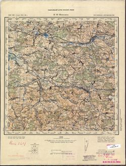
- Description:
- 1896
- Subject:
- Topical Subject: Maps, Topical Subject: Soviet Union, and Geographic Subject: Mościska
- Publisher:
- Генеральный штаб Красной Армии
- Language:
- Russian
- Date Created:
- 1940
- Identifier:
- VAC9619-003018
- Genre:
- Military Maps and Topographic Maps
- Geographic Location:
- Coordinates: 49.667, 23, 50, 23.5
- Related URL:
- Download GeoTIFF: https://drive.google.com/file/d/1kY545RVscWvC3Hu8ZYE51ce4nlHz2vcF/view?usp=sharing and Catalog URL: https://iucat.iu.edu/catalog/5020129
- Abstract:
- Modern area represented: Mościska, Lviv oblast, Ukraine
- Call Number:
- G7000 s100 .S7 sheet M-34-83
- City:
- Мосьциска (Mościska)
- Copyright Holder:
- No Copyright - United States
- Country:
- СССР (USSR)
- State/Province:
- Дрогобычская область (Drohobych oblast), Львовская область (Lviv oblast), and Украинская ССР (Ukrainian Soviet Socialist Republic)
- Physical Description:
- Scale: 1:100,000
- Persistent URL:
- http://purl.dlib.indiana.edu/iudl/images/VAC9619/VAC9619-003018
- Provenance:
- Army Map Service Library, CIA Map Branch -- Received
-
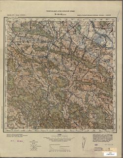
- Description:
- 1900
- Subject:
- Geographic Subject: Dukla, Topical Subject: Maps, and Topical Subject: Soviet Union
- Publisher:
- Генеральный штаб Красной Армии
- Language:
- Russian
- Date Created:
- 1940
- Identifier:
- VAC9619-003026
- Genre:
- Topographic Maps and Military Maps
- Geographic Location:
- Coordinates: 49.333, 21.5, 49.667, 22
- Related URL:
- Catalog URL: https://iucat.iu.edu/catalog/5020129 and Download GeoTIFF: https://drive.google.com/file/d/1e6hl_8RYVtO4gyTqSy4BwZgpUBKrnpPl/view?usp=sharing
- Abstract:
- Modern area represented: Dukla, Subcarpathian province, Poland
- Call Number:
- G7000 s100 .S7 sheet M-34-92
- City:
- Дукля (Dukla)
- Copyright Holder:
- No Copyright - United States
- Country:
- Словакия (Slovakia)
- State/Province:
- Область государственных интересов Германии (Region of German state interests)
- Physical Description:
- Scale: 1:100,000
- Persistent URL:
- http://purl.dlib.indiana.edu/iudl/images/VAC9619/VAC9619-003026
- Provenance:
- DMA Topographic Center, Army Map Service Library, OMAHA
-
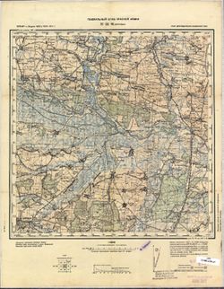
- Description:
- 1875
- Subject:
- Topical Subject: Soviet Union, Geographic Subject: Drohobych, and Topical Subject: Maps
- Publisher:
- Генеральный штаб Красной Армии
- Language:
- Russian
- Date Created:
- 1940
- Identifier:
- VAC9619-003027
- Genre:
- Military Maps and Topographic Maps
- Geographic Location:
- Coordinates: 49.333, 23.5, 49.667, 24
- Related URL:
- Catalog URL: https://iucat.iu.edu/catalog/5020129 and Download GeoTIFF: https://drive.google.com/file/d/10E4Z3oRj75pa2_d4MwidMWMnRE09xm2x/view?usp=sharing
- Abstract:
- Modern area represented: Drohobych, Lviv oblast, Ukraine
- Call Number:
- G7000 s100 .S7 sheet M-34-96
- City:
- Дрогобыч (Drohobych)
- Copyright Holder:
- No Copyright - United States
- Country:
- СССР (USSR)
- State/Province:
- Украинская ССР (Ukrainian Soviet Socialist Republic), Дрогобычская область (Drohobych oblast), and Львовская область (Lviv oblast)
- Physical Description:
- Scale: 1:100,000
- Persistent URL:
- http://purl.dlib.indiana.edu/iudl/images/VAC9619/VAC9619-003027
- Provenance:
- CIA Map Library
-
- Description:
- 1901
- Subject:
- Topical Subject: Maps, Topical Subject: Soviet Union, and Geographic Subject: Myślenice
- Publisher:
- Генеральный штаб Красной Армии
- Language:
- Russian
- Date Created:
- 1940
- Identifier:
- VAC9619-002872
- Genre:
- Topographic Maps and Military Maps
- Geographic Location:
- Coordinates: 49.667, 19.5, 50, 20
- Related URL:
- Download GeoTIFF: https://drive.google.com/file/d/1i8W5Rov2G2PC8B-kAt5IGRNa_NTKCPlr/view?usp=sharing and Catalog URL: https://iucat.iu.edu/catalog/5020129
- Abstract:
- Modern area represented: Myślenice, Lesser Poland province, Poland
- Call Number:
- G7000 s100 .S7 sheet M-34-76
- City:
- Мысьленице (Myślenice)
- Copyright Holder:
- No Copyright - United States
- State/Province:
- Область государственных интересов Германии (Region of German state interests)
- Physical Description:
- Scale: 1:100,000
- Persistent URL:
- http://purl.dlib.indiana.edu/iudl/images/VAC9619/VAC9619-002872
- Provenance:
- DMA Topographic Center, Army Map Service Library, OMAHA
-
- Description:
- 1900
- Subject:
- Topical Subject: Maps, Geographic Subject: Bochnia, and Topical Subject: Soviet Union
- Publisher:
- Генеральный штаб Красной Армии
- Language:
- Russian
- Date Created:
- 1940
- Identifier:
- VAC9619-002873
- Genre:
- Military Maps and Topographic Maps
- Geographic Location:
- Coordinates: 49.667, 20, 50, 20.5
- Related URL:
- Catalog URL: https://iucat.iu.edu/catalog/5020129 and Download GeoTIFF: https://drive.google.com/file/d/1EDzSRqMxPGvslBNvsKXYdyf2xkgptZse/view?usp=sharing
- Abstract:
- Modern area represented: Bochnia, Lesser Poland province, Poland
- Call Number:
- G7000 s100 .S7 sheet M-34-77
- City:
- Бохня (Bochnia)
- Copyright Holder:
- No Copyright - United States
- State/Province:
- Область государственных интересов Германии (Region of German state interests)
- Physical Description:
- Scale: 1:100,000
- Persistent URL:
- http://purl.dlib.indiana.edu/iudl/images/VAC9619/VAC9619-002873
- Provenance:
- DMA Topographic Center, Army Map Service Library, OMAHA, Geographic Names Branch
-
- Description:
- 1896
- Subject:
- Geographic Subject: Lubaczów, Topical Subject: Maps, and Topical Subject: Soviet Union
- Publisher:
- Генеральный штаб Красной Армии
- Language:
- Russian
- Date Created:
- 1940
- Identifier:
- VAC9619-002869
- Genre:
- Military Maps and Topographic Maps
- Geographic Location:
- Coordinates: 50, 23, 50.333, 23.5
- Related URL:
- Catalog URL: https://iucat.iu.edu/catalog/5020129 and Download GeoTIFF: https://drive.google.com/file/d/1LrfPq8nyC_ARr2re7UK6PWr3HSY57xXQ/view?usp=sharing
- Abstract:
- Modern area represented: Lubaczów, Subcarpathian province, Poland
- Call Number:
- G7000 s100 .S7 sheet M-34-71
- City:
- Любачев (Lubaczów)
- Copyright Holder:
- No Copyright - United States
- Country:
- СССР (USSR)
- State/Province:
- Украинская ССР (Ukrainian Soviet Socialist Republic), Львовская область (Lviv oblast), and Область государственных интересов Германии (Region of German state...
- Physical Description:
- Scale: 1:100,000
- Persistent URL:
- http://purl.dlib.indiana.edu/iudl/images/VAC9619/VAC9619-002869
- Provenance:
- DMA Topographic Center, Army Map Service Library, Auswärtiges Amt. Geographischer Dienst
-
- Description:
- 1875
- Subject:
- Topical Subject: Soviet Union, Geographic Subject: Przeworsk, and Topical Subject: Maps
- Publisher:
- Генеральный штаб Красной Армии
- Language:
- Russian
- Date Created:
- 1940
- Identifier:
- VAC9619-002868
- Genre:
- Topographic Maps and Military Maps
- Geographic Location:
- Coordinates: 50, 22, 50.333, 22.5
- Related URL:
- Catalog URL: https://iucat.iu.edu/catalog/5020129 and Download GeoTIFF: https://drive.google.com/file/d/1oCqOtN6Te7oAxQACpnA02llWGY9nkUcN/view?usp=sharing
- Abstract:
- Modern area represented: Przeworsk, Subcarpathian province, Poland
- Call Number:
- G7000 s100 .S7 sheet M-34-69
- City:
- Пшевурск (Przeworsk)
- Copyright Holder:
- No Copyright - United States
- State/Province:
- Область государственных интересов Германии (Region of German state interests)
- Physical Description:
- Scale: 1:100,000
- Persistent URL:
- http://purl.dlib.indiana.edu/iudl/images/VAC9619/VAC9619-002868
- Provenance:
- DMA Topographic Center, Army Map Service Library
-
- Description:
- 1898
- Subject:
- Geographic Subject: Ropczyce, Topical Subject: Maps, and Topical Subject: Soviet Union
- Publisher:
- Генеральный штаб Красной Армии
- Language:
- Russian
- Date Created:
- 1940
- Identifier:
- VAC9619-002867
- Genre:
- Topographic Maps and Military Maps
- Geographic Location:
- Coordinates: 50, 21.5, 50.333, 22
- Related URL:
- Catalog URL: https://iucat.iu.edu/catalog/5020129 and Download GeoTIFF: https://drive.google.com/file/d/19Rh3Ua_G5ljdOoF9neRQsQPqzkNLXgTP/view?usp=sharing
- Abstract:
- Modern area represented: Ropczyce, Subcarpathian province, Poland
- Call Number:
- G7000 s100 .S7 sheet M-34-68
- City:
- Ропчице (Ropczyce)
- Copyright Holder:
- No Copyright - United States
- State/Province:
- Область государственных интересов Германии (Region of German state interests)
- Physical Description:
- Scale: 1:100,000
- Persistent URL:
- http://purl.dlib.indiana.edu/iudl/images/VAC9619/VAC9619-002867
- Provenance:
- DMA Topographic Center, Army Map Service Library
-
- Description:
- 1898
- Subject:
- Topical Subject: Soviet Union, Topical Subject: Maps, and Geographic Subject: Dębica
- Publisher:
- Генеральный штаб Красной Армии
- Language:
- Russian
- Date Created:
- 1940
- Identifier:
- VAC9619-002866
- Genre:
- Topographic Maps and Military Maps
- Geographic Location:
- Coordinates: 50, 21, 50.333, 21.5
- Related URL:
- Catalog URL: https://iucat.iu.edu/catalog/5020129 and Download GeoTIFF: https://drive.google.com/file/d/1Uy6ofukadNUJXLmDEIrhqb_c8F1atEvZ/view?usp=sharing
- Abstract:
- Modern area represented: Dębica, Subcarpathian province, Poland
- Call Number:
- G7000 s100 .S7 sheet M-34-67
- City:
- Дембица (Dembica)
- Copyright Holder:
- No Copyright - United States
- State/Province:
- Область государственных интересов Германии (Region of German state interests)
- Physical Description:
- Scale: 1:100,000
- Persistent URL:
- http://purl.dlib.indiana.edu/iudl/images/VAC9619/VAC9619-002866
- Provenance:
- DMA Topographic Center, Army Map Service Library
-
- Description:
- 1893
- Subject:
- Topical Subject: Maps, Geographic Subject: Tarnów, and Topical Subject: Soviet Union
- Publisher:
- Генеральный штаб Красной Армии
- Language:
- Russian
- Date Created:
- 1940
- Identifier:
- VAC9619-002865
- Genre:
- Military Maps and Topographic Maps
- Geographic Location:
- Coordinates: 50, 20.5, 50.333, 21
- Related URL:
- Download GeoTIFF: https://drive.google.com/file/d/1sfPl4-UBMbIYwVDlMiLFy8Et4a_ZNYE0/view?usp=sharing and Catalog URL: https://iucat.iu.edu/catalog/5020129
- Abstract:
- Modern area represented: Tarnów, Lesser Poland province, Poland
- Call Number:
- G7000 s100 .S7 sheet M-34-66
- City:
- Тарнув (Tarnów)
- Copyright Holder:
- No Copyright - United States
- State/Province:
- Область государственных интересов Германии (Region of German state interests)
- Physical Description:
- Scale: 1:100,000
- Persistent URL:
- http://purl.dlib.indiana.edu/iudl/images/VAC9619/VAC9619-002865
- Provenance:
- DMA Topographic Center, Army Map Service Library
-
- Description:
- 1895
- Subject:
- Topical Subject: Maps, Topical Subject: Soviet Union, and Geographic Subject: Niepołomice
- Publisher:
- Генеральный штаб Красной Армии
- Language:
- Russian
- Date Created:
- 1940
- Identifier:
- VAC9619-002864
- Genre:
- Military Maps and Topographic Maps
- Geographic Location:
- Coordinates: 50, 20, 50.333, 20.5
- Related URL:
- Catalog URL: https://iucat.iu.edu/catalog/5020129 and Download GeoTIFF: https://drive.google.com/file/d/1coFHyZ0WlU2BWdczsQQU63t1T5g7dZTV/view?usp=sharing
- Abstract:
- Modern area represented: Niepołomice, Lesser Poland province, Poland
- Call Number:
- G7000 s100 .S7 sheet M-34-65
- City:
- Неполомице (Niepołomice)
- Copyright Holder:
- No Copyright - United States
- State/Province:
- Область государственных интересов Германии (Region of German state interests)
- Physical Description:
- Scale: 1:100,000
- Persistent URL:
- http://purl.dlib.indiana.edu/iudl/images/VAC9619/VAC9619-002864
- Provenance:
- DMA Topographic Center, Army Map Service Library
-
- Description:
- 1895
- Subject:
- Topical Subject: Maps, Geographic Subject: Krakow, and Topical Subject: Soviet Union
- Publisher:
- Генеральный штаб Красной Армии
- Language:
- Russian
- Date Created:
- 1940
- Identifier:
- VAC9619-002863
- Genre:
- Topographic Maps and Military Maps
- Geographic Location:
- Coordinates: 50, 19.5, 50.333, 20
- Related URL:
- Catalog URL: https://iucat.iu.edu/catalog/5020129 and Download GeoTIFF: https://drive.google.com/file/d/12u_yo99kDUoSZLyDlYIII3Xjrkl0yhgW/view?usp=sharing
- Abstract:
- Modern area represented: Krakow, Lesser Poland province, Poland
- Call Number:
- G7000 s100 .S7 sheet M-34-64
- City:
- Краков (Krakow)
- Copyright Holder:
- No Copyright - United States
- State/Province:
- Область государственных интересов Германии (Region of German state interests)
- Physical Description:
- Scale: 1:100,000
- Persistent URL:
- http://purl.dlib.indiana.edu/iudl/images/VAC9619/VAC9619-002863
- Provenance:
- DMA Topographic Center, Army Map Service Library, Library of Congress Geography & Map Division, Atlasblatt
-
- Description:
- 1896
- Subject:
- Topical Subject: Soviet Union, Geographic Subject: Katowice, and Topical Subject: Maps
- Publisher:
- Генеральный штаб Красной Армии
- Language:
- Russian
- Date Created:
- 1940
- Identifier:
- VAC9619-002862
- Genre:
- Topographic Maps and Military Maps
- Geographic Location:
- Coordinates: 50, 19, 50.333, 19.5
- Related URL:
- Catalog URL: https://iucat.iu.edu/catalog/5020129 and Download GeoTIFF: https://drive.google.com/file/d/1jVwnEnut9hOzj9dvqs5LRp2cJarooOxx/view?usp=sharing
- Abstract:
- Modern area represented: Katowice, Silesian province, Poland
- Call Number:
- G7000 s100 .S7 sheet M-34-63
- City:
- Каттовиц (Kattowitz)
- Copyright Holder:
- No Copyright - United States
- Country:
- Германия (Germany)
- State/Province:
- Область государственных интересов Германии (Region of German state interests)
- Physical Description:
- Scale: 1:100,000
- Persistent URL:
- http://purl.dlib.indiana.edu/iudl/images/VAC9619/VAC9619-002862
- Provenance:
- DMA Topographic Center, Army Map Service Library, Library of Congress Geography & Map Division, Geographic Names Branch
-

- Description:
- 1882
- Subject:
- Geographic Subject: Racibórz, Topical Subject: Soviet Union, and Topical Subject: Maps
- Publisher:
- Генеральный штаб Красной Армии
- Language:
- Russian
- Date Created:
- 1940
- Identifier:
- VAC9619-002860
- Genre:
- Military Maps and Topographic Maps
- Geographic Location:
- Coordinates: 50, 18, 50.333, 18.5
- Related URL:
- Download GeoTIFF: https://drive.google.com/file/d/1XcG44qM_SkibVzjFK8EuHetzDeu3O5g7/view?usp=sharing and Catalog URL: https://iucat.iu.edu/catalog/5020129
- Abstract:
- Modern area represented: Racibórz, Silesian province, Poland
- Call Number:
- G7000 s100 .S7 sheet M-34-61
- City:
- Ратибор (Ratibor)
- Copyright Holder:
- No Copyright - United States
- Country:
- Германия (Germany)
- Physical Description:
- Scale: 1:100,000
- Persistent URL:
- http://purl.dlib.indiana.edu/iudl/images/VAC9619/VAC9619-002860
- Provenance:
- DMA Topographic Center, Army Map Service Library, Library of Congress Geography & Map Division
-
- Description:
- 1883
- Subject:
- Topical Subject: Maps, Topical Subject: Soviet Union, and Geographic Subject: Zabrze
- Publisher:
- Генеральный штаб Красной Армии
- Language:
- Russian
- Date Created:
- 1940
- Identifier:
- VAC9619-002861
- Genre:
- Military Maps and Topographic Maps
- Geographic Location:
- Coordinates: 50, 18.5, 50.333, 19
- Related URL:
- Catalog URL: https://iucat.iu.edu/catalog/5020129 and Download GeoTIFF: https://drive.google.com/file/d/1sDDZR5sQRloUr3WJ3L7tUb7R4IcBSezh/view?usp=sharing
- Abstract:
- Modern area represented: Zabrze, Silesian province, Poland
- Call Number:
- G7000 s100 .S7 sheet M-34-62
- City:
- Гинденбург (Hindenburg)
- Copyright Holder:
- No Copyright - United States
- Country:
- Германия (Germany)
- Physical Description:
- Scale: 1:100,000
- Persistent URL:
- http://purl.dlib.indiana.edu/iudl/images/VAC9619/VAC9619-002861
- Provenance:
- DMA Topographic Center, Army Map Service Library, Library of Congress Geography & Map Division
-
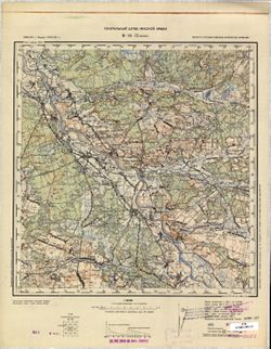
- Description:
- 1892
- Subject:
- Topical Subject: Soviet Union, Topical Subject: Maps, and Geographic Subject: Nisko
- Publisher:
- Генеральный штаб Красной Армии
- Language:
- Russian
- Date Created:
- 1940
- Identifier:
- VAC9619-002858
- Genre:
- Military Maps and Topographic Maps
- Geographic Location:
- Coordinates: 50.333, 22, 50.667, 22.5
- Related URL:
- Catalog URL: https://iucat.iu.edu/catalog/5020129 and Download GeoTIFF: https://drive.google.com/file/d/1d3pXcqZSIlNNtASH5Dg9hJnWboaE_CRO/view?usp=sharing
- Abstract:
- Modern area represented: Nisko, Subcarpathian province, Poland
- Call Number:
- G7000 s100 .S7 sheet M-34-57
- City:
- Ниско (Nisko)
- Copyright Holder:
- No Copyright - United States
- State/Province:
- Область государственных интересов Германии (Region of German state interests)
- Physical Description:
- Scale: 1:100,000
- Persistent URL:
- http://purl.dlib.indiana.edu/iudl/images/VAC9619/VAC9619-002858
- Provenance:
- CIA Map Library, CIA Map Branch -- Received
-
- Description:
- 1893
- Subject:
- Topical Subject: Soviet Union, Geographic Subject: Staszów, and Topical Subject: Maps
- Publisher:
- Генеральный штаб Красной Армии
- Language:
- Russian
- Date Created:
- 1940
- Identifier:
- VAC9619-002856
- Genre:
- Military Maps and Topographic Maps
- Geographic Location:
- Coordinates: 50.333, 21, 50.667, 21.5
- Related URL:
- Download GeoTIFF: https://drive.google.com/file/d/1R2h75uIaVFfookFli0p85iELEPArrEVP/view?usp=sharing and Catalog URL: https://iucat.iu.edu/catalog/5020129
- Abstract:
- Modern area represented: Staszów, Świętokrzyskie province, Poland
- Call Number:
- G7000 s100 .S7 sheet M-34-55
- City:
- Сташув (Staszów)
- Copyright Holder:
- No Copyright - United States
- State/Province:
- Область государственных интересов Германии (Region of German state interests)
- Physical Description:
- Scale: 1:100,000
- Persistent URL:
- http://purl.dlib.indiana.edu/iudl/images/VAC9619/VAC9619-002856
- Provenance:
- DMA Topographic Center, Army Map Service Library, Library of Congress Geography & Map Division
