
Search Constraints
Search Results
-
- Description:
- 1918
- Subject:
- Topical Subject: Maps, Geographic Subject: Humenné, and Topical Subject: Soviet Union
- Publisher:
- Генеральный штаб РККА
- Language:
- Russian
- Date Created:
- 1930
- Identifier:
- VAC9619-003033
- Genre:
- Military Maps and Topographic Maps
- Geographic Location:
- Coordinates: 48.667, 21.5, 49, 22
- Related URL:
- Catalog URL: https://iucat.iu.edu/catalog/5020129 and Download GeoTIFF: https://drive.google.com/file/d/1UfoCS_lkiSzRj7RFBn3W3tTjol7sBXu4/view?usp=sharing
- Abstract:
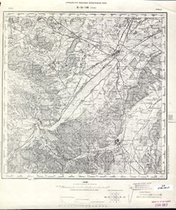
- Modern area represented: Humenné, Prešov region, Slovakia
- Call Number:
- G7000 s100 .S7 sheet M-34-116
- City:
- Гуменне (Humenné)
- Copyright Holder:
- No Copyright - United States
- Country:
- Чехословакия (Czechoslovakia)
- Physical Description:
- Scale: 1:100,000
- Persistent URL:
- http://purl.dlib.indiana.edu/iudl/images/VAC9619/VAC9619-003033
- Provenance:
- DMA Topographic Center, Army Map Service Library, OMAHA
-
- Description:
- 1875
- Subject:
- Topical Subject: Maps, Geographic Subject: Stryi, and Topical Subject: Soviet Union
- Publisher:
- Управление военных топографов РККА
- Language:
- Russian
- Identifier:
- VAC9619-003032
- Genre:
- Topographic Maps and Military Maps
- Geographic Location:
- Coordinates: 49, 23.5, 49.333, 24
- Related URL:
- Download GeoTIFF: https://drive.google.com/file/d/1m69aijWH7x29h9SgndppVfXfVxppcnxQ/view?usp=sharing and Catalog URL: https://iucat.iu.edu/catalog/5020129
- Abstract:
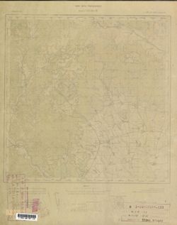
- Modern area represented: Stryi, Lviv oblast, Ukraine
- Call Number:
- G7000 s100 .S7 sheet M-34-108
- City:
- Стрый (Stryi)
- Copyright Holder:
- No Copyright - United States
- Country:
- Польша (Poland)
- Physical Description:
- Scale: 1:100,000
- Persistent URL:
- http://purl.dlib.indiana.edu/iudl/images/VAC9619/VAC9619-003032
- Provenance:
- CIA Map Library
-
- Description:
- 1918
- Subject:
- Topical Subject: Maps, Topical Subject: Soviet Union, and Geographic Subject: Snina
- Publisher:
- Генеральный штаб РККА
- Language:
- Russian
- Date Created:
- 1925
- Identifier:
- VAC9619-003034
- Genre:
- Topographic Maps and Military Maps
- Geographic Location:
- Coordinates: 48.667, 22, 49, 22.5
- Related URL:
- Download GeoTIFF: https://drive.google.com/file/d/1eYLLQmDE0BEdDJTKHZCDTSblgzjcflBF/view?usp=sharing and Catalog URL: https://iucat.iu.edu/catalog/5020129
- Abstract:
- Modern area represented: Snina, Prešov region, Slovakia
- Call Number:
- G7000 s100 .S7 sheet M-34-117
- City:
- Снина (Snina)
- Copyright Holder:
- No Copyright - United States
- Country:
- Чехословакия (Czechoslovakia)
- Physical Description:
- Scale: 1:100,000
- Persistent URL:
- http://purl.dlib.indiana.edu/iudl/images/VAC9619/VAC9619-003034
- Provenance:
- DMA Topographic Center, Army Map Service Library, OMAHA, Library of Congress Geography & Map Division
-
- Description:
- 1894
- Subject:
- Geographic Subject: Trebišov, Topical Subject: Soviet Union, and Topical Subject: Maps
- Publisher:
- Генеральный штаб РККА
- Language:
- Russian
- Date Created:
- 1930
- Identifier:
- VAC9619-003035
- Genre:
- Topographic Maps and Military Maps
- Geographic Location:
- Coordinates: 48.333, 21.5, 48.667, 22
- Related URL:
- Download GeoTIFF: https://drive.google.com/file/d/1LmckQjcnTSlgrhDD_Fg6_PNmOntT-DDS/view?usp=sharing and Catalog URL: https://iucat.iu.edu/catalog/5020129
- Abstract:
- Modern area represented: Trebišov, Slovakia
- Call Number:
- G7000 s100 .S7 sheet M-34-128
- City:
- Требишов (Trebišov)
- Copyright Holder:
- No Copyright - United States
- Country:
- Венгрия (Hungary) and Чехословакия (Czechoslovakia)
- Physical Description:
- Scale: 1:100,000
- Persistent URL:
- http://purl.dlib.indiana.edu/iudl/images/VAC9619/VAC9619-003035
- Provenance:
- DMA Topographic Center, Army Map Service Library, OMAHA, Atlasblatt
-
- Description:
- 1925
- Subject:
- Geographic Subject: Uzhhorod, Topical Subject: Soviet Union, and Topical Subject: Maps
- Publisher:
- Генеральный штаб РККА
- Language:
- Russian
- Date Created:
- 1931
- Identifier:
- VAC9619-003036
- Genre:
- Topographic Maps and Military Maps
- Geographic Location:
- Coordinates: 48.333, 22, 48.667, 22.5
- Related URL:
- Download GeoTIFF: https://drive.google.com/file/d/1DdieUulMtsvn8jRNO_P8TCGdHSITuvCE/view?usp=sharing and Catalog URL: https://iucat.iu.edu/catalog/5020129
- Abstract:
- Modern area represented: Uzhhorod, Zakarpatska oblast, Ukraine
- Call Number:
- G7000 s100 .S7 sheet M-34-129
- City:
- Ужгород (Uzhhorod)
- Copyright Holder:
- No Copyright - United States
- Country:
- Чехословакия (Czechoslovakia)
- Physical Description:
- Scale: 1:100,000
- Persistent URL:
- http://purl.dlib.indiana.edu/iudl/images/VAC9619/VAC9619-003036
- Provenance:
- DMA Topographic Center, Army Map Service Library, Library of Congress Geography & Map Division
-
- Description:
- 1915
- Subject:
- Geographic Subject: Mukachevo, Topical Subject: Soviet Union, and Topical Subject: Maps
- Publisher:
- Генеральный штаб РККА
- Language:
- Russian
- Date Created:
- 1931
- Identifier:
- VAC9619-003037
- Genre:
- Topographic Maps and Military Maps
- Geographic Location:
- Coordinates: 48.333, 22.5, 48.667, 23
- Related URL:
- Catalog URL: https://iucat.iu.edu/catalog/5020129 and Download GeoTIFF: https://drive.google.com/file/d/1eCfewS1HQMYb6NAbk07G9MN9_68zMG0D/view?usp=sharing
- Abstract:
- Modern area represented: Mukachevo, Zakarpattia oblast, Ukraine
- Call Number:
- G7000 s100 .S7 sheet M-34-130
- City:
- Мукачево (Mukachevo)
- Copyright Holder:
- No Copyright - United States
- Country:
- Чехословакия (Czechoslovakia)
- Physical Description:
- Scale: 1:100,000
- Persistent URL:
- http://purl.dlib.indiana.edu/iudl/images/VAC9619/VAC9619-003037
- Provenance:
- Library of Congress G & M Division, Army Map Service Library, Geographic Names Branch
-
- Description:
- 1915
- Subject:
- Topical Subject: Maps, Topical Subject: Soviet Union, and Geographic Subject: Dovhe
- Publisher:
- Генеральный штаб Красной Армии
- Language:
- Russian
- Date Created:
- 1938
- Identifier:
- VAC9619-003038
- Genre:
- Military Maps and Topographic Maps
- Geographic Location:
- Coordinates: 48.333, 23, 48.667, 23.5
- Related URL:
- Catalog URL: https://iucat.iu.edu/catalog/5020129 and Download GeoTIFF: https://drive.google.com/file/d/1Vah3w10ssNOu-oswhVk2lEej6k1722u8/view?usp=sharing
- Abstract:
- Modern area represented: Dovhe, Zakarpattia oblast, Ukraine
- Call Number:
- G7000 s100 .S7 sheet M-34-131
- City:
- Довге (Dovhe)
- Copyright Holder:
- No Copyright - United States
- Country:
- Карпатская Украина (Carpatho-Ukraine) and Венгрия (Hungary)
- Physical Description:
- Scale: 1:100,000
- Persistent URL:
- http://purl.dlib.indiana.edu/iudl/images/VAC9619/VAC9619-003038
- Provenance:
- DMA Topographic Center, Army Map Service Library, OMAHA, Library of Congress Geography & Map Division
-
- Description:
- 1906
- Subject:
- Topical Subject: Maps, Topical Subject: Soviet Union, and Geographic Subject: Sárospatak
- Publisher:
- Генеральный штаб РККА
- Language:
- Russian
- Date Created:
- 1929
- Identifier:
- VAC9619-003040
- Genre:
- Topographic Maps and Military Maps
- Geographic Location:
- Coordinates: 48, 21.5, 48.333, 22
- Related URL:
- Catalog URL: https://iucat.iu.edu/catalog/5020129 and Download GeoTIFF: https://drive.google.com/file/d/1laj3DaHLLjRgi4B0A1p4PGRRtZkriz4h/view?usp=sharing
- Abstract:
- Modern area represented: Sárospatak, Borsod-Abaúj-Zemplén county, Hungary
- Call Number:
- G7000 s100 .S7 sheet M-34-140
- City:
- Шарош-Патак (Sáros-Patak)
- Copyright Holder:
- No Copyright - United States
- Country:
- Чехословакия (Czechoslovakia) and Венгрия (Hungary)
- Physical Description:
- Scale: 1:100,000
- Persistent URL:
- http://purl.dlib.indiana.edu/iudl/images/VAC9619/VAC9619-003040
- Provenance:
- DMA Topographic Center, Army Map Service Library, OMAHA, Library of Congress Geography & Map Division
-
- Description:
- 1924
- Subject:
- Topical Subject: Maps, Geographic Subject: Mizhhirya, and Topical Subject: Soviet Union
- Publisher:
- Генеральный штаб РККА
- Language:
- Russian
- Date Created:
- 1935
- Identifier:
- VAC9619-003039
- Genre:
- Topographic Maps and Military Maps
- Geographic Location:
- Coordinates: 48.333, 23.5, 48.667, 24
- Related URL:
- Catalog URL: https://iucat.iu.edu/catalog/5020129 and Download GeoTIFF: https://drive.google.com/file/d/1yVnWYBItNhx_XHqZ-7kSIPPBjMUlbt22/view?usp=sharing
- Abstract:
- Modern area represented: Mizhhirya, Zakarpattia oblast, Ukraine
- Call Number:
- G7000 s100 .S7 sheet M-34-132
- City:
- Волове (Volové)
- Copyright Holder:
- No Copyright - United States
- Country:
- Чехословакия (Czechoslovakia) and Польша (Poland)
- Physical Description:
- Scale: 1:100,000
- Persistent URL:
- http://purl.dlib.indiana.edu/iudl/images/VAC9619/VAC9619-003039
- Provenance:
- DMA Topographic Center, Army Map Service Library, OMAHA, Library of Congress Geography & Map Division
-

- Description:
- 1908
- Subject:
- Topical Subject: Maps, Topical Subject: Soviet Union, and Geographic Subject: Vásárosnamény
- Publisher:
- Генеральный штаб РККА
- Language:
- Russian
- Date Created:
- 1931
- Identifier:
- VAC9619-003041
- Genre:
- Military Maps and Topographic Maps
- Geographic Location:
- Coordinates: 48, 22, 48.333, 22.5
- Related URL:
- Download GeoTIFF: https://drive.google.com/file/d/1fJ2L085r4a0gnyVd-c_Ch5Lf8tWqS7Dz/view?usp=sharing and Catalog URL: https://iucat.iu.edu/catalog/5020129
- Abstract:
- Modern area represented: Vásárosnamény, Szabolcs-Szatmár-Bereg county, Hungary
- Call Number:
- G7000 s100 .S7 sheet M-34-141
- City:
- Вашарошнамень (Vásárosnamény)
- Copyright Holder:
- No Copyright - United States
- Country:
- Чехословакия (Czechoslovakia) and Венгрия (Hungary)
- Physical Description:
- Scale: 1:100,000
- Persistent URL:
- http://purl.dlib.indiana.edu/iudl/images/VAC9619/VAC9619-003041
- Provenance:
- DMA Topographic Center, Army Map Service Library, OMAHA, Library of Congress Geography & Map Division
