
Search Constraints
« Previous |
1 - 20 of 297
|
Next »
Search Results
-
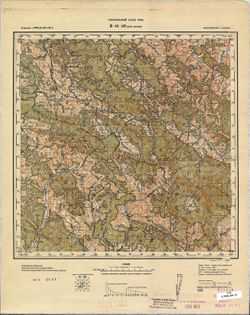
- Description:
- 1853
- Subject:
- Geographic Subject: Laptevo, Topical Subject: Soviet Union, and Topical Subject: Maps
- Publisher:
- Управление военных топографов
- Language:
- Russian
- Date Created:
- 1930
- Identifier:
- VAC9619-001599
- Genre:
- Topographic Maps and Military Maps
- Geographic Location:
- Coordinates: 54.333, 37.573, 54.5, 37.823
- Related URL:
- Catalog URL: http://iucat.iu.edu/catalog/5020131 and Download GeoTIFF: https://drive.google.com/file/d/1aGuqwqLIQb2dh7zU2_a7HtzP9CLQ1XqP/view?usp=sharing
- Abstract:
- Modern area represented: Laptevo, Tula oblast, Russia
- Call Number:
- G7000 s50 .S68 sheet N-37-52-В/Г
- City:
- Ст. Лаптево (Laptevo)
- Copyright Holder:
- No Copyright - United States
- Country:
- СССР (USSR)
- State/Province:
- Московская область (Moscow oblast) and РСФСР (RSFSR)
- Physical Description:
- Scale: 1:50,000
- Persistent URL:
- http://purl.dlib.indiana.edu/iudl/images/VAC9619/VAC9619-001599
- Provenance:
- Army Map Service Library, Library of Congress Geography & Map Division, OMAHA
-
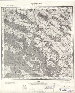
- Description:
- 1929
- Subject:
- Topical Subject: Soviet Union, Geographic Subject: Novyy Barsuk, and Topical Subject: Maps
- Publisher:
- Управление военных топографов
- Language:
- Russian
- Date Created:
- 1930
- Identifier:
- VAC9619-001565
- Genre:
- Military Maps and Topographic Maps
- Geographic Location:
- Coordinates: 52, 30.25, 52.1667, 30.5
- Related URL:
- Download GeoTIFF: https://drive.google.com/open?id=1xAqaU1gE6Y2IhwXoJ_TpZglXYfUyXzwM and Catalog URL: http://iucat.iu.edu/catalog/5020131
- Abstract:
- Modern area represented: Novyy Barsuk, Homyel Voblasc, Belarus
- Call Number:
- G7000 s50 .S68 sheet N-36-133-Г
- Caption:
- Не подлежит оглашению
- City:
- Нов. Барсук (Novyy Barsuk)
- Copyright Holder:
- No Copyright - United States
- Country:
- СССР (USSR)
- State/Province:
- Белорусская ССР (Byelorussian Soviet Socialist Republic)
- Physical Description:
- Scale: 1:50,000
- Persistent URL:
- http://purl.dlib.indiana.edu/iudl/images/VAC9619/VAC9619-001565
- Provenance:
- M. I. Map Library, G000-30
-
- Description:
- 1874
- Subject:
- Topical Subject: Maps, Topical Subject: Soviet Union, and Geographic Subject: Velykyy Bychkiv
- Publisher:
- Генеральный штаб РККА
- Language:
- Russian
- Date Created:
- 1930
- Identifier:
- VAC9619-001463
- Genre:
- Topographic Maps and Military Maps
- Geographic Location:
- Coordinates: 47.6667, 24, 48, 24.5
- Related URL:
- Download GeoTIFF: https://drive.google.com/open?id=1-ZSf5C8bFAhpm68pW7TQgPOdfxwZluL5 and Catalog URL: https://iucat.iu.edu/catalog/5020129
- Abstract:
- Modern area represented: Velykyy Bychkiv, Transcarpathia oblast, Ukraine
- Call Number:
- G7000 s100 .S7 sheet L-35-1
- City:
- Над-Бочко (Nad-Bochko)
- Copyright Holder:
- No Copyright - United States
- Country:
- Чехословакия (Czechoslovakia) and Румыния (Romania)
- Physical Description:
- Scale: 1:100,000
- Persistent URL:
- http://purl.dlib.indiana.edu/iudl/images/VAC9619/VAC9619-001463
- Provenance:
- CIA Map Library
-
- Description:
- 1883
- Subject:
- Topical Subject: Soviet Union, Geographic Subject: Tășnad, and Topical Subject: Maps
- Publisher:
- Генеральный штаб РККА
- Language:
- Russian
- Date Created:
- 1930
- Identifier:
- VAC9619-001461
- Genre:
- Military Maps and Topographic Maps
- Geographic Location:
- Coordinates: 47.3333, 22.5, 47.6667, 23
- Related URL:
- Download GeoTIFF: https://drive.google.com/open?id=1k8qkUtzCZ2Jxn-mGGkXXacO87N-pZgZF and Catalog URL: https://iucat.iu.edu/catalog/5020129
- Abstract:
- Modern area represented: Tășnad, Satu Mare county, Romania
- Call Number:
- G7000 s100 .S7 sheet L-34-22
- City:
- Ташнад (Tășnad)
- Copyright Holder:
- No Copyright - United States
- Country:
- Румыния (Romania)
- Physical Description:
- Scale: 1:100,000
- Persistent URL:
- http://purl.dlib.indiana.edu/iudl/images/VAC9619/VAC9619-001461
- Provenance:
- CIA Map Library, Library of Congress Geography & Map Division
-
- Description:
- 1924
- Subject:
- Topical Subject: Maps, Geographic Subject: Paradino, and Topical Subject: Soviet Union
- Publisher:
- Управление военных топографов
- Language:
- Russian
- Date Created:
- 1930
- Identifier:
- VAC9619-001407
- Genre:
- Topographic Maps and Military Maps
- Geographic Location:
- Coordinates: 53.833, 31.75, 54, 32
- Related URL:
- Download GeoTIFF: https://drive.google.com/open?id=1AhOKXg8J2ZdNFGTxJTkCtYk-xvD_Ga-G and Catalog URL: http://iucat.iu.edu/catalog/5020131
- Abstract:
- Modern area represented: Paradino, Mogilev oblast, Belarus
- Call Number:
- GM G7000 S50 .S68 N-36-76-Б
- Caption:
- Не подлежит оглашению
- City:
- Парадино (Paradino)
- Copyright Holder:
- No Copyright - United States
- Country:
- СССР (USSR)
- State/Province:
- Западная область (Western oblast), Белорусская ССР (Byelorussian Soviet Socialist Republic), and РСФСР (RSFSR)
- Physical Description:
- Scale: 1:50,000
- Persistent URL:
- http://purl.dlib.indiana.edu/iudl/images/VAC9619/VAC9619-001407
- Provenance:
- Library of Congress Geography & Map Division, Army Map Service Library, OMAHA
-
- Description:
- 1924
- Subject:
- Topical Subject: Maps, Topical Subject: Soviet Union, and Geographic Subject: Molyatichi
- Publisher:
- Военно-топографическое управление
- Language:
- Russian
- Date Created:
- 1930
- Identifier:
- VAC9619-001406
- Genre:
- Topographic Maps and Military Maps
- Geographic Location:
- Coordinates: 53.833, 31.5, 54, 31.75
- Related URL:
- Catalog URL: http://iucat.iu.edu/catalog/5020131 and Download GeoTIFF: https://drive.google.com/open?id=1mDv-xjRxQ9MN0tnibRm-9T4vbq1BeRhJ
- Abstract:
- Modern area represented: Molyatichi, Mogilev oblast, Belarus
- Call Number:
- GM G7000 S50 .S68 N-36-76-A
- Caption:
- Не подлежит оглашению
- City:
- Молятичи (Molyatichi)
- Copyright Holder:
- No Copyright - United States
- Country:
- СССР (USSR)
- State/Province:
- Белорусская ССР (Byelorussian Soviet Socialist Republic)
- Physical Description:
- Scale: 1:50,000
- Persistent URL:
- http://purl.dlib.indiana.edu/iudl/images/VAC9619/VAC9619-001406
- Provenance:
- DMA Topographic Center, Army Map Service Library, OMAHA, Library of Congress Geography & Map Division
-
- Description:
- 1929
- Subject:
- Topical Subject: Maps, Geographic Subject: Malodusha, and Topical Subject: Soviet Union
- Publisher:
- Генеральный штаб РККА
- Language:
- Russian
- Date Created:
- 1930
- Identifier:
- VAC9619-004211
- Genre:
- Military Maps and Topographic Maps
- Geographic Location:
- Coordinates: 52, 30, 52.333, 30.5
- Related URL:
- Download GeoTIFF: https://drive.google.com/file/d/1vss8uAeY0wn5MsDvFBZiLPkPyXj1hMDz/view?usp=sharing and Catalog URL: https://iucat.iu.edu/catalog/5020129
- Abstract:
- Modern area represented: Malodusha, Homyel oblast, Belarus
- Call Number:
- G7000 s100 .S7 sheet N-36-133
- Caption:
- Не подлежит оглашению
- City:
- Малодуш (Malodush)
- Copyright Holder:
- No Copyright - United States
- Country:
- СССР (USSR)
- State/Province:
- Белорусская ССР (Byelorussian Soviet Socialist Republic)
- Physical Description:
- Scale: 1:100,000
- Persistent URL:
- http://purl.dlib.indiana.edu/iudl/images/VAC9619/VAC9619-004211
- Provenance:
- DMA Topographic Center, Army Map Service Library, OMAHA, Library of Congress Geography & Map Division
-
- Description:
- 1898
- Subject:
- Topical Subject: Soviet Union, Geographic Subject: Starie Peski, and Topical Subject: Maps
- Publisher:
- Генеральный штаб РККА
- Language:
- Russian
- Date Created:
- 1930
- Identifier:
- VAC9619-004127
- Genre:
- Military Maps and Topographic Maps
- Geographic Location:
- Coordinates: 52.333, 25, 52.667, 25.5
- Related URL:
- Catalog URL: https://iucat.iu.edu/catalog/5020129 and Download GeoTIFF: https://drive.google.com/file/d/1Ieu3hB2w5rZSrBgsB0smd2GsJMhMYPiw/view?usp=sharing
- Abstract:
- Modern area represented: Starie Peski, Brest oblast, Belarus
- Call Number:
- G7000 s100 .S7 sheet N-35-123
- City:
- Пяски Стары (Pyaski Stary)
- Copyright Holder:
- No Copyright - United States
- Country:
- Польша (Poland)
- Physical Description:
- Scale: 1:100,000
- Persistent URL:
- http://purl.dlib.indiana.edu/iudl/images/VAC9619/VAC9619-004127
- Provenance:
- DMA Topographic Center, Army Map Service Library, OMAHA
-
- Description:
- 1883
- Subject:
- Geographic Subject: Kosava, Topical Subject: Soviet Union, and Topical Subject: Maps
- Publisher:
- Генеральный штаб РККА
- Language:
- Russian
- Date Created:
- 1930
- Identifier:
- VAC9619-004115
- Genre:
- Topographic Maps and Military Maps
- Geographic Location:
- Coordinates: 52.667, 25, 53, 25.5
- Related URL:
- Download GeoTIFF: https://drive.google.com/file/d/1TWYz3K6LX5xkvtCmyBqKyZWyLs0_5tEU/view?usp=sharing and Catalog URL: https://iucat.iu.edu/catalog/5020129
- Abstract:
- Modern area represented: Kosava, Brest oblast, Belarus
- Call Number:
- G7000 s100 .S7 sheet N-35-111
- City:
- Косув (Kosuv)
- Copyright Holder:
- No Copyright - United States
- Country:
- СССР (USSR)
- State/Province:
- Белорусская ССР (Byelorussian Soviet Socialist Republic)
- Physical Description:
- Scale: 1:100,000
- Persistent URL:
- http://purl.dlib.indiana.edu/iudl/images/VAC9619/VAC9619-004115
- Provenance:
- DMA Topographic Center, Army Map Service Library, OMAHA
-
- Description:
- 1910
- Subject:
- Topical Subject: Maps, Geographic Subject: Budsław, and Topical Subject: Soviet Union
- Publisher:
- Генеральный штаб РККА
- Language:
- Russian
- Date Created:
- 1930
- Identifier:
- VAC9619-004045
- Genre:
- Military Maps and Topographic Maps
- Geographic Location:
- Coordinates: 54.667, 27, 55, 27.5
- Related URL:
- Catalog URL: https://iucat.iu.edu/catalog/5020129 and Download GeoTIFF: https://drive.google.com/file/d/14qh0_HR2_iLnZGYebT5_sip_B1pLZikd/view?usp=sharing
- Abstract:
- Modern area represented: Budsław, Belarus
- Call Number:
- G7000 s100 .S7 sheet N-35-43
- City:
- Будслав (Budsław)
- Copyright Holder:
- No Copyright - United States
- Country:
- СССР (USSR)
- State/Province:
- Белорусская ССР (Byelorussian Soviet Socialist Republic)
- Physical Description:
- Scale: 1:100,000
- Persistent URL:
- http://purl.dlib.indiana.edu/iudl/images/VAC9619/VAC9619-004045
- Provenance:
- DMA Topographic Center, Army Map Service Library, Auswärtiges Amt. Geographischer Dienst
-
- Description:
- 1916
- Subject:
- Topical Subject: Maps, Topical Subject: Soviet Union, and Geographic Subject: Hlybokaye
- Publisher:
- Генеральный штаб РККА
- Language:
- Russian
- Date Created:
- 1930
- Identifier:
- VAC9619-004035
- Genre:
- Military Maps and Topographic Maps
- Geographic Location:
- Coordinates: 55, 27.5, 55.333, 28
- Related URL:
- Catalog URL: https://iucat.iu.edu/catalog/5020129 and Download GeoTIFF: https://drive.google.com/file/d/1v8yq-tb1ESjZKfTBUaVuwOGTPAQCNjBn/view?usp=sharing
- Abstract:
- Modern area represented: Hlybokaye, Vitebsk oblast, Belarus
- Call Number:
- G7000 s100 .S7 sheet N-35-32
- City:
- Гленбоке (Glębokie)
- Copyright Holder:
- No Copyright - United States
- Country:
- Польша (Poland)
- Physical Description:
- Scale: 1:100,000
- Persistent URL:
- http://purl.dlib.indiana.edu/iudl/images/VAC9619/VAC9619-004035
- Provenance:
- DMA Topographic Center, Army Map Service Library, Geographic Names Branch
-
- Description:
- 1913
- Subject:
- Topical Subject: Maps, Geographic Subject: Krāslava, and Topical Subject: Soviet Union
- Publisher:
- Генеральный штаб РККА
- Language:
- Russian
- Date Created:
- 1930
- Identifier:
- VAC9619-004009
- Genre:
- Topographic Maps and Military Maps
- Geographic Location:
- Coordinates: 55.667, 27, 56, 27.5
- Related URL:
- Catalog URL: https://iucat.iu.edu/catalog/5020129 and Download GeoTIFF: https://drive.google.com/file/d/12N6kf5hWYLgmEFN-uQGVmIYt7tuSBHGk/view?usp=sharing
- Abstract:
- Modern area represented: Krāslava, Krāslavas novads, Latvia
- Call Number:
- G7000 s100 .S7 sheet N-35-7
- City:
- Крааслава (Krāslava)
- Copyright Holder:
- No Copyright - United States
- Country:
- Латвия (Latvia) and Польша (Poland)
- Physical Description:
- Scale: 1:100,000
- Persistent URL:
- http://purl.dlib.indiana.edu/iudl/images/VAC9619/VAC9619-004009
- Provenance:
- DMA Topographic Center, Army Map Service Library, OMAHA, Library of Congress Geography & Map Division
-
- Description:
- 1884
- Subject:
- Geographic Subject: Lomza, Topical Subject: Soviet Union, and Topical Subject: Maps
- Publisher:
- Генеральный штаб РККА
- Language:
- Russian
- Date Created:
- 1930
- Identifier:
- VAC9619-004003
- Genre:
- Military Maps and Topographic Maps
- Geographic Location:
- Coordinates: 53, 22, 53.333, 22.5
- Related URL:
- Download GeoTIFF: https://drive.google.com/file/d/1oIYQOvf9T9bGlBoG0SMFcZh7VIar6p8C/view?usp=sharing and Catalog URL: https://iucat.iu.edu/catalog/5020129
- Abstract:
- Modern area represented: Lomza, Podlaskie Voivodeship, Poland
- Call Number:
- G7000 s100 .S7 sheet N-34-105
- City:
- Ломжа (Lomza)
- Copyright Holder:
- No Copyright - United States
- Country:
- Польша (Poland)
- Physical Description:
- Scale: 1:100,000
- Persistent URL:
- http://purl.dlib.indiana.edu/iudl/images/VAC9619/VAC9619-004003
- Provenance:
- DMA Topographic Center, Army Map Service Library, OMAHA
-
- Description:
- 1874
- Subject:
- Topical Subject: Maps, Geographic Subject: Kuty, and Topical Subject: Soviet Union
- Publisher:
- Генеральный штаб РККА
- Language:
- Russian
- Date Created:
- 1930
- Identifier:
- VAC9619-003250
- Genre:
- Military Maps and Topographic Maps
- Geographic Location:
- Coordinates: 48, 25, 48.333, 25.5
- Related URL:
- Catalog URL: https://iucat.iu.edu/catalog/5020129 and Download GeoTIFF: https://drive.google.com/file/d/1OBM3F_GE0UNZx2WA1df1vLDc0nqmgENq/view?usp=sharing
- Abstract:
- Modern area represented: Kuty, Ivano-Frankivsk oblast, Ukraine
- Call Number:
- G7000 s100 .S7 sheet M-35-135
- City:
- Куты (Kuty)
- Copyright Holder:
- No Copyright - United States
- Country:
- Польша (Poland) and Румыния (Romania)
- Physical Description:
- Scale: 1:100,000
- Persistent URL:
- http://purl.dlib.indiana.edu/iudl/images/VAC9619/VAC9619-003250
- Provenance:
- DMA Topographic Center, Army Map Service Library, OMAHA
-
- Description:
- 1918
- Subject:
- Geographic Subject: Wola Michowa, Topical Subject: Soviet Union, and Topical Subject: Maps
- Publisher:
- Генеральный штаб РККА
- Language:
- Russian
- Date Created:
- 1930
- Identifier:
- VAC9619-003029
- Genre:
- Military Maps and Topographic Maps
- Geographic Location:
- Coordinates: 49, 22, 49.333, 22.5
- Related URL:
- Catalog URL: https://iucat.iu.edu/catalog/5020129 and Download GeoTIFF: https://drive.google.com/file/d/1gIN67lRHUmXMAreXLfv0KuKc2MGQwhLr/view?usp=sharing
- Abstract:
- Modern area represented: Wola Michowa, Subcarpathian province, Poland
- Call Number:
- G7000 s100 .S7 sheet M-34-105
- City:
- Воля Михова (Wola Michowa)
- Copyright Holder:
- No Copyright - United States
- Country:
- Чехословакия (Czechoslovakia) and Польша (Poland)
- Physical Description:
- Scale: 1:100,000
- Persistent URL:
- http://purl.dlib.indiana.edu/iudl/images/VAC9619/VAC9619-003029
- Provenance:
- CIA Map Library
-
- Description:
- 1909
- Subject:
- Geographic Subject: Lutowiska, Topical Subject: Soviet Union, and Topical Subject: Maps
- Publisher:
- Генеральный штаб РККА
- Language:
- Russian
- Date Created:
- 1930
- Identifier:
- VAC9619-003030
- Genre:
- Military Maps and Topographic Maps
- Geographic Location:
- Coordinates: 49, 22.5, 49.333, 23
- Related URL:
- Catalog URL: https://iucat.iu.edu/catalog/5020129 and Download GeoTIFF: https://drive.google.com/file/d/1Krhy099-J2gYbPw-jiaJdVsFpUXCwMvQ/view?usp=sharing
- Abstract:
- Modern area represented: Lutowiska, Subcarpathian province, Poland
- Call Number:
- G7000 s100 .S7 sheet M-34-106
- City:
- Лютовиска (Lutowiska)
- Copyright Holder:
- No Copyright - United States
- Country:
- Чехословакия (Czechoslovakia) and Польша (Poland)
- Physical Description:
- Scale: 1:100,000
- Persistent URL:
- http://purl.dlib.indiana.edu/iudl/images/VAC9619/VAC9619-003030
- Provenance:
- CIA Map Library
-
- Description:
- 1918
- Subject:
- Topical Subject: Maps, Geographic Subject: Humenné, and Topical Subject: Soviet Union
- Publisher:
- Генеральный штаб РККА
- Language:
- Russian
- Date Created:
- 1930
- Identifier:
- VAC9619-003033
- Genre:
- Military Maps and Topographic Maps
- Geographic Location:
- Coordinates: 48.667, 21.5, 49, 22
- Related URL:
- Catalog URL: https://iucat.iu.edu/catalog/5020129 and Download GeoTIFF: https://drive.google.com/file/d/1UfoCS_lkiSzRj7RFBn3W3tTjol7sBXu4/view?usp=sharing
- Abstract:
- Modern area represented: Humenné, Prešov region, Slovakia
- Call Number:
- G7000 s100 .S7 sheet M-34-116
- City:
- Гуменне (Humenné)
- Copyright Holder:
- No Copyright - United States
- Country:
- Чехословакия (Czechoslovakia)
- Physical Description:
- Scale: 1:100,000
- Persistent URL:
- http://purl.dlib.indiana.edu/iudl/images/VAC9619/VAC9619-003033
- Provenance:
- DMA Topographic Center, Army Map Service Library, OMAHA
-
- Description:
- 1894
- Subject:
- Geographic Subject: Trebišov, Topical Subject: Soviet Union, and Topical Subject: Maps
- Publisher:
- Генеральный штаб РККА
- Language:
- Russian
- Date Created:
- 1930
- Identifier:
- VAC9619-003035
- Genre:
- Topographic Maps and Military Maps
- Geographic Location:
- Coordinates: 48.333, 21.5, 48.667, 22
- Related URL:
- Download GeoTIFF: https://drive.google.com/file/d/1LmckQjcnTSlgrhDD_Fg6_PNmOntT-DDS/view?usp=sharing and Catalog URL: https://iucat.iu.edu/catalog/5020129
- Abstract:
- Modern area represented: Trebišov, Slovakia
- Call Number:
- G7000 s100 .S7 sheet M-34-128
- City:
- Требишов (Trebišov)
- Copyright Holder:
- No Copyright - United States
- Country:
- Венгрия (Hungary) and Чехословакия (Czechoslovakia)
- Physical Description:
- Scale: 1:100,000
- Persistent URL:
- http://purl.dlib.indiana.edu/iudl/images/VAC9619/VAC9619-003035
- Provenance:
- DMA Topographic Center, Army Map Service Library, OMAHA, Atlasblatt
-
- Subject:
- Geographic Subject: Kurgolovo, Topical Subject: Maps, and Topical Subject: Soviet Union
- Publisher:
- Управление военных топографов
- Language:
- Russian
- Date Created:
- 1930
- Identifier:
- VAC9619-002643
- Genre:
- Military Maps and Topographic Maps
- Geographic Location:
- Coordinates: 59.667, 28, 59.833, 28.25
- Related URL:
- Catalog URL: http://iucat.iu.edu/catalog/5020131 and Download GeoTIFF: https://drive.google.com/file/d/1TMQIN6mjxb72bXCZWjieR5pgWRwY1VaN/view?usp=sharing
- Abstract:
- Modern area represented: Kurgolovo, Leningrad oblast, Russia
- Call Number:
- GM G7000 s50 .S68 sheet M-35-9-C
- Caption:
- Не подлежит оглашению
- City:
- Курголово (Kurgolovo)
- Copyright Holder:
- No Copyright - United States
- Country:
- СССР (USSR)
- State/Province:
- РСФСР (RSFSR) and Ленинградская область (Leningrad oblast)
- Physical Description:
- Scale: 1:50,000
- Persistent URL:
- http://purl.dlib.indiana.edu/iudl/images/VAC9619/VAC9619-002643
- Provenance:
- Army Map Service Library, OMAHA, Library of Congress Geography & Map Division
-
- Description:
- 1929
- Subject:
- Geographic Subject: Velykyy Buyalyk, Topical Subject: Soviet Union, and Topical Subject: Maps
- Publisher:
- Генеральный штаб РККА
- Language:
- Russian
- Date Created:
- 1930
- Identifier:
- VAC9619-001882
- Genre:
- Military Maps and Topographic Maps
- Geographic Location:
- Coordinates: 46.6667, 30.5, 47, 31
- Related URL:
- Catalog URL: https://iucat.iu.edu/catalog/5020129 and Download GeoTIFF: https://drive.google.com/file/d/1D95GxNaBBveCQQS6T-FYUU94outwvOte/view?usp=sharing
- Abstract:
- Modern area represented: Velykyy Buyalyk, Odessa oblast, Ukraine
- Call Number:
- G7000 s100 .S7 sheet L-36-38
- Caption:
- Не подлежит оглашению
- City:
- Благоево (Blagoyevo)
- Copyright Holder:
- No Copyright - United States
- Country:
- СССР (USSR)
- State/Province:
- Украинская ССР (Ukrainian Soviet Socialist Republic) and Одесская область (Odessa oblast)
- Physical Description:
- Scale: 1:100,000
- Persistent URL:
- http://purl.dlib.indiana.edu/iudl/images/VAC9619/VAC9619-001882
- Provenance:
- DMA Topographic Center, Library of Congress G & M Division
