
Search Constraints
You searched for:
Date Created
1970
Remove constraint Date Created: 1970
Holding Location
B-WELLS
Remove constraint Holding Location: B-WELLS
« Previous |
1 - 10 of 96
|
Next »
Search Results
-
![Area map [map] : Nashville and park entrance](https://iiif.uits.iu.edu/iiif/2/cf95kd75c%2Ffiles%2F50f0a63b-dc6d-4bda-a229-140148a2252e/full/250,/0/default.jpg)
- Subject:
- Geographic Subject: Brown County State Park (Ind.) and Geographic Subject: Nashville (Ind.)
- Publisher:
- [publisher not identified]
- Date Created:
- 1970
- Identifier:
- VAC3073-M-00225
- Genre:
- Maps
- Geographic Location:
- Coordinates: W0861450 W0861220 N0391229 N0391130
- Related URL:
- Catalog URL: https://iucat.iu.edu/catalog/4896982
- Abstract:
- Blue line print. Shows corporate limits of Nashville Indiana, roads, some buildings, Salt Creek, the north entrance to Brown County State Park and distances...
- Call Number:
- G4094 .N25 1970 .A74
- Caption:
- Imprint: [place of publication not identified] : [publisher not identified], [1970?]
- Physical Description:
- Dimensions: 42 x 66 cm and Scale: Scale not given.
- Alternate Identifier:
- Title Control Number: a4896982
- Persistent URL:
- https://purl.dlib.indiana.edu/iudl/images/VAC3073/VAC3073-M-00225
-
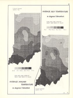
- Subject:
- Topical Subject: SYMAP (Computer program language), Topical Subject: Atmospheric temperature, and Geographic Subject: Indiana
- Creator:
- Kingsbury, Robert C.
- Publisher:
- Indiana University. Department of Geography
- Date Created:
- 1970
- Identifier:
- VAC3073-M-01021
- Genre:
- Thematic maps
- Geographic Location:
- Coordinates: W0880700 W0844500 N0414500 N0374600
- Related URL:
- Catalog URL: https://iucat.iu.edu/catalog/15995455
- Abstract:
- 2 maps on 1 sheet, Average January temperature in degrees Fahrenheit and Average July temperature in degrees Fahrenheit. Computer generated isometric maps ob...
- Call Number:
- G4091.C82 1970 .K57
- Caption:
- Imprint: Bloomington, Indiana : Department of Geography, Indiana University, [1970]
- Physical Description:
- Dimensions: each 26 x 10 cm, on sheet 28 x 21 cm and Scale: Approximately 1:3,000,000
- Alternate Identifier:
- Title Control Number: a15995455 and Alternate ID: 317383IP
- Persistent URL:
- https://purl.dlib.indiana.edu/iudl/images/VAC3073/VAC3073-M-01021
- Provenance:
- An atlas of Indiana / by Robert C. Kingsbury [1970].
-
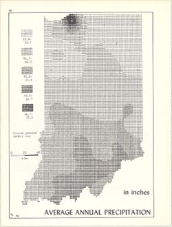
- Subject:
- Topical Subject: Rain and rainfall, Topical Subject: SYMAP (Computer program language), and Geographic Subject: Indiana
- Creator:
- Kingsbury, Robert C. and Indiana University. Research Computing Center
- Publisher:
- Indiana University. Department of Geography
- Date Created:
- 1970
- Identifier:
- VAC3073-M-00141
- Genre:
- Thematic maps
- Geographic Location:
- Coordinates: W0880700 W0844500 N0414500 N0374600
- Related URL:
- Catalog URL: https://iucat.iu.edu/catalog/15995731
- Abstract:
- Computer generated isometric map obtained through use of the facilities of Indiana University's Research Computer Center. ASCII-art map created using SYM...
- Call Number:
- G4091.C883 1970 .K56
- Caption:
- Imprint: Bloomington, Indiana : Department of Geography, Indiana University, [1970]
- Physical Description:
- Dimensions: 26 x 18 cm and Scale: Approximately 1:1,950,000
- Alternate Identifier:
- Title Control Number: a15995731 and Alternate ID: 317383IP
- Persistent URL:
- https://purl.dlib.indiana.edu/iudl/images/VAC3073/VAC3073-M-00141
- Provenance:
- An atlas of Indiana / by Robert C. Kingsbury [1970].
-
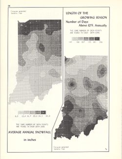
- Subject:
- Geographic Subject: Indiana, Topical Subject: SYMAP (Computer program language), Topical Subject: Phytogeography, and Topical Subject: Snow
- Creator:
- Kingsbury, Robert C. and Indiana University. Research Computing Center
- Publisher:
- Indiana University. Department of Geography
- Date Created:
- 1970
- Identifier:
- VAC3073-M-00043
- Genre:
- Thematic maps
- Geographic Location:
- Coordinates: W0880700 W0844500 N0414500 N0374600
- Related URL:
- Catalog URL: https://iucat.iu.edu/catalog/15998435
- Abstract:
- 2 maps on 1 sheet, Average annual snowfall in inches and Length of the growing season: number of days above 32°F. annually. Computer generated isometric ...
- Call Number:
- G4091.C884 1970 .K56
- Caption:
- Imprint: Bloomington, Indiana : Department of Geography, Indiana University, [1970]
- Physical Description:
- Scale: Approximately 1:3,000,000 and Dimensions: each 26 x 10 cm, on sheet 28 x 21 cm
- Alternate Identifier:
- Alternate ID: 317383IP and Title Control Number: a15998435
- Persistent URL:
- https://purl.dlib.indiana.edu/iudl/images/VAC3073/VAC3073-M-00043
- Provenance:
- An atlas of Indiana / by Robert C. Kingsbury [1970].
-
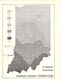
- Subject:
- Topical Subject: SYMAP (Computer program language), Geographic Subject: Indiana, and Topical Subject: Atmospheric temperature
- Creator:
- Indiana University. Research Computing Center and Kingsbury, Robert C.
- Publisher:
- Indiana University. Department of Geography
- Date Created:
- 1970
- Identifier:
- VAC3073-M-00805
- Genre:
- Thematic maps
- Geographic Location:
- Coordinates: W0880700 W0844500 N0414500 N0374600
- Related URL:
- Catalog URL: https://iucat.iu.edu/catalog/15995471
- Abstract:
- Computer generated isometric map obtained through use of the facilities of Indiana University's Research Computer Center. ASCII-art map created using SYM...
- Call Number:
- G4091.C82 1970 .K56
- Caption:
- Imprint: Bloomington, Indiana : Department of Geography, Indiana University, [1970]
- Physical Description:
- Dimensions: 26 x 18 cm and Scale: Approximately 1:1,950,000
- Alternate Identifier:
- Alternate ID: 317383IP and Title Control Number: a15995471
- Persistent URL:
- https://purl.dlib.indiana.edu/iudl/images/VAC3073/VAC3073-M-00805
- Provenance:
- An atlas of Indiana / by Robert C. Kingsbury [1970].
-
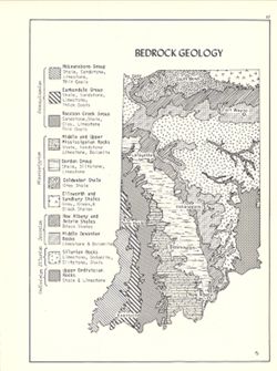
- Subject:
- Topical Subject: Geology, Geographic Subject: Indiana, and Topical Subject: Geology, Structural
- Creator:
- Hollingsworth, John M. and Kingsbury, Robert C.
- Publisher:
- Indiana University. Department of Geography
- Date Created:
- 1970
- Identifier:
- VAC3073-M-00305
- Genre:
- Geological maps
- Geographic Location:
- Coordinates: W0880700 W0844500 N0414500 N0374600
- Related URL:
- Catalog URL: https://iucat.iu.edu/catalog/15939159
- Abstract:
- Includes geological time table. Detached from: An atlas of Indiana / by Robert C. Kingsbury , with contributions from John M. Hollingsworth and others. Bl...
- Call Number:
- G4091.C5 1970 .K57
- Caption:
- Imprint: Bloomington, Indiana : Department of Geography, Indiana University, [1970]
- Physical Description:
- Dimensions: 26 x 18 cm, on sheet 28 x 21 cm and Scale: Approximately 1:2,150,000
- Alternate Identifier:
- Title Control Number: a15939159 and Alternate ID: 317383IP
- Persistent URL:
- https://purl.dlib.indiana.edu/iudl/images/VAC3073/VAC3073-M-00305
- Provenance:
- An atlas of Indiana / by Robert C. Kingsbury [1970].
-
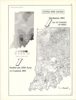
- Subject:
- Topical Subject: SYMAP (Computer program language), Geographic Subject: Indiana, and Topical Subject: Cattle--Geographical distribution
- Creator:
- Hollingsworth, John M., Indiana University. Research Computing Center, and Kingsbury, Robert C.
- Publisher:
- Indiana University. Department of Geography
- Date Created:
- 1970
- Identifier:
- VAC3073-M-00066
- Genre:
- Thematic maps
- Geographic Location:
- Coordinates: W0880700 W0844500 N0414500 N0374600
- Related URL:
- Catalog URL: https://iucat.iu.edu/catalog/15736851
- Abstract:
- Dot distribution map. Includes ancillary computer generated isopleth map Cattle and calves: number per 1,000 acres of cropland, 1964. ASCII-art map created u...
- Call Number:
- G4091.J5 1964 .K56
- Caption:
- Imprint: Bloomington, Indiana : Department of Geography, Indiana University, [1970]
- Physical Description:
- Scale: 1:2,534,400 and Dimensions: 26 x 18 cm
- Alternate Identifier:
- Alternate ID: 317383IP and Title Control Number: a15736851
- Persistent URL:
- https://purl.dlib.indiana.edu/iudl/images/VAC3073/VAC3073-M-00066
- Provenance:
- An atlas of Indiana / by Robert C. Kingsbury [1970].
-
- Subject:
- Topical Subject: Commuters and Geographic Subject: Indiana
- Creator:
- Indiana. Employment Security Division. Research and Statistics Section
- Publisher:
- Indiana. Employment Security Division. Research and Statistics Section
- Date Created:
- 1970
- Identifier:
- VAC3073-M-00354
- Genre:
- Statistical maps and Thematic maps
- Geographic Location:
- Coordinates: W0880500 W0844700 N0414500 N0374600
- Related URL:
- Catalog URL: https://iucat.iu.edu/catalog/1212285
- Abstract:
- "Source: 1970 census." "Counts of under 50 are omitted."
- Call Number:
- G4091 .G8 1970 .I53
- Caption:
- Imprint: [Indianapolis,] : The Research and statistics Section, Indiana Employment Security Division, [1970?]
- Physical Description:
- Dimensions: 25 x 17 cm and Scale: Scale not given.
- Alternate Identifier:
- Title Control Number: AKJ0410BB
- Persistent URL:
- https://purl.dlib.indiana.edu/iudl/images/VAC3073/VAC3073-M-00354
-
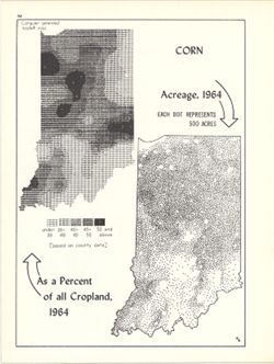
- Subject:
- Topical Subject: SYMAP (Computer program language), Topical Subject: Corn--Geographical distribution, Geographic Subject: Indiana, and Topical Subject: Phyto...
- Creator:
- Hollingsworth, John M., Indiana University. Research Computing Center, and Kingsbury, Robert C.
- Publisher:
- Indiana University. Department of Geography
- Date Created:
- 1970
- Identifier:
- VAC3073-M-00267
- Genre:
- Thematic maps
- Geographic Location:
- Coordinates: W0880700 W0844500 N0414500 N0374600
- Related URL:
- Catalog URL: https://iucat.iu.edu/catalog/15984676
- Abstract:
- Dot distribution map. Includes ancillary computer generated isopleth map Corn as a percent of all cropland, 1964. ASCII-art map created using SYMAP or simila...
- Call Number:
- G4091.J7 1964 .K56
- Caption:
- Imprint: Bloomington, Indiana : Department of Geography, Indiana University, [1970]
- Physical Description:
- Scale: Approximately 1:2,534,400 and Dimensions: 26 x 18 cm, on sheet 28 x 21 cm
- Alternate Identifier:
- Title Control Number: a15984676 and Alternate ID: 317383IP
- Persistent URL:
- https://purl.dlib.indiana.edu/iudl/images/VAC3073/VAC3073-M-00267
- Provenance:
- An atlas of Indiana / by Robert C. Kingsbury [1970].
-
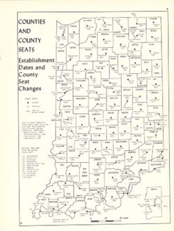
- Subject:
- Topical Subject: Counties, Topical Subject: Cities and towns, Geographic Subject: Indiana, and Topical Subject: Administrative and political divisions
- Creator:
- Hollingsworth, John M. and Kingsbury, Robert C.
- Publisher:
- Indiana University. Department of Geography
- Date Created:
- 1970
- Identifier:
- VAC3073-M-00655
- Genre:
- Thematic maps
- Geographic Location:
- Coordinates: W0880700 W0844500 N0414500 N0374600
- Related URL:
- Catalog URL: https://iucat.iu.edu/catalog/15942435
- Abstract:
- Shows county seat establishment dates and county seat changes. Includes map insert of Martin County, Indiana. Detached from: An atlas of Indiana / by Robe...
- Call Number:
- G4091.F7 1970 .K57
- Caption:
- Imprint: Bloomington, Indiana : Department of Geography, Indiana University, [1970]
- Physical Description:
- Dimensions: 26 x 18 cm, on sheet 28 x 21 cm and Scale: Approximately 1:1,800,000
- Alternate Identifier:
- Alternate ID: 317383IP and Title Control Number: a15942435
- Persistent URL:
- https://purl.dlib.indiana.edu/iudl/images/VAC3073/VAC3073-M-00655
- Provenance:
- An atlas of Indiana / by Robert C. Kingsbury [1970].
