
Search Constraints
Search Results
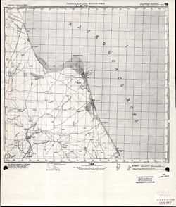
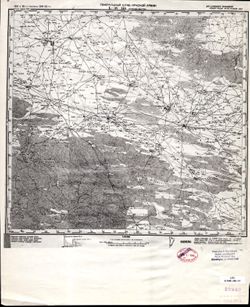
-
- Description:
- 1939
- Subject:
- Geographic Subject: Kamyzyak, Topical Subject: Maps, Topical Subject: Soviet Union, and Geographic Subject: Astrakhan Oblast
- Publisher:
- Наркомрыбпром Главрыбвод
- Language:
- Russian
- Date Created:
- 1940
- Identifier:
- VAC9619-002256
- Genre:
- Military Maps and Topographic Maps
- Geographic Location:
- Coordinates: 46, 48, 46.3333, 48.5
- Related URL:
- Catalog URL: https://iucat.iu.edu/catalog/5020129 and Download GeoTIFF: https://drive.google.com/file/d/1COuEZimX0zDKPsy-a9vlykqgrNjh2Jla/view?usp=sharing
- Abstract:
- Modern area represented: Камызяк (Kamyzyak), Astrakhan Oblast, Russia
- Call Number:
- G7000 s100 .S7 sheet L-39-61
- Caption:
- Рабочий оттиск. Бесплатно. Временное Издание. Для внутреннего использования.
- City:
- Камызяк (Kamyzyak)
- Copyright Holder:
- No Copyright - United States
- Country:
- СССР (USSR)
- State/Province:
- РСФСР (RSFSR) and Сталинградская область (Stalingrad oblast)
- Physical Description:
- Scale: 1:100,000
- Persistent URL:
- http://purl.dlib.indiana.edu/iudl/images/VAC9619/VAC9619-002256
- Provenance:
- DMA Topographic Center, Army Map Service Library
-
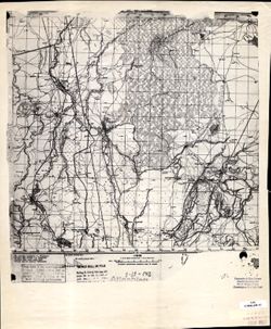
- Description:
- 1939
- Subject:
- Topical Subject: Maps, Geographic Subject: Atyraū, Topical Subject: Soviet Union, and Geographic Subject: Surkhan
- Publisher:
- Наркомрыбпром Главрыбвод
- Language:
- Russian
- Identifier:
- VAC9619-002255
- Genre:
- Topographic Maps and Military Maps
- Geographic Location:
- Coordinates: 46.3333, 49.5, 46.6667, 50
- Related URL:
- Download GeoTIFF: https://drive.google.com/file/d/17dQsDfhKepOgCTMRu9XS9x3X0Ssg7hAK/view?usp=sharing and Catalog URL: https://iucat.iu.edu/catalog/5020129
- Abstract:
- Modern area represented: Сурхан (Surkhan), Atyraū, Kazakhstan
- Call Number:
- G7000 s100 .S7 sheet L-39-52
- Caption:
- Для внутреннего использования. Рабочий оттиск. Бесплатно.
- City:
- Сурхан (Surkhan)
- Copyright Holder:
- No Copyright - United States
- Country:
- СССР (USSR)
- State/Province:
- Казахская ССР (Kazakh Soviet Socialist Republic) and Гуриевская область (Guriev oblast)
- Physical Description:
- Scale: 1:100,000
- Persistent URL:
- http://purl.dlib.indiana.edu/iudl/images/VAC9619/VAC9619-002255
- Provenance:
- DMA Topographic Center, Army Map Service Library
-
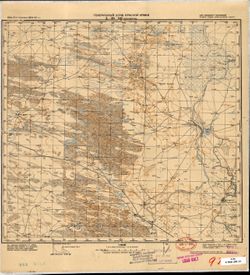
- Description:
- 1939
- Subject:
- Topical Subject: Maps, Geographic Subject: Astrakhan, Topical Subject: Soviet Union, and Geographic Subject: Astrakhan Oblast’
- Publisher:
- Наркомрыбпром Главрыбвод
- Language:
- Russian
- Date Created:
- 1940
- Identifier:
- VAC9619-002254
- Genre:
- Topographic Maps and Military Maps
- Geographic Location:
- Coordinates: 46.3333, 48, 46.6667, 48.5
- Related URL:
- Catalog URL: https://iucat.iu.edu/catalog/5020129 and Download GeoTIFF: https://drive.google.com/file/d/1RCqPg_tDMJxKMYAkWR-P5U_oyqYZuJMF/view?usp=sharing
- Abstract:
- Modern area represented: Астрахань (Astrakhan), Astrakhan Oblast’, Russia
- Call Number:
- G7000 s100 .S7 sheet L-39-49
- City:
- Астрахань (Astrakhan)
- Copyright Holder:
- No Copyright - United States
- Country:
- СССР (USSR)
- State/Province:
- РСФСР (RSFSR), Калмыцкая АССР (Kalmyk Autonomous Soviet Socialist Republic), and Сталинградская область (Stalingrad oblast)
- Physical Description:
- Scale: 1:100,000
- Persistent URL:
- http://purl.dlib.indiana.edu/iudl/images/VAC9619/VAC9619-002254
- Provenance:
- DMA Topographic Center, Army Map Service Library
-
- Description:
- 1939
- Subject:
- Topical Subject: Soviet Union and Topical Subject: Maps
- Publisher:
- Наркомрыбпром Главрыбвод
- Language:
- Russian
- Date Created:
- 1940
- Identifier:
- VAC9619-002253
- Genre:
- Topographic Maps and Military Maps
- Geographic Location:
- Coordinates: 46.6667, 48.5, 47, 49
- Related URL:
- Download GeoTIFF: https://drive.google.com/file/d/12YwoFqwwXRltjU5q71pYY85QKDnbyHn9/view?usp=sharing and Catalog URL: https://iucat.iu.edu/catalog/5020129
- Abstract:
- Modern area represented:
- Call Number:
- G7000 s100 .S7 sheet L-39-38
- Copyright Holder:
- No Copyright - United States
- Country:
- СССР (USSR)
- State/Province:
- РСФСР (RSFSR), Сталинградская область (Stalingrad oblast), Гуриевская область (Guriev oblast), and Казахская ССР (Kazakh Soviet Socialist Republic)
- Physical Description:
- Scale: 1:100,000
- Persistent URL:
- http://purl.dlib.indiana.edu/iudl/images/VAC9619/VAC9619-002253
- Provenance:
- DMA Topographic Center, Army Map Service Library
-
- Description:
- 1939
- Subject:
- Topical Subject: Soviet Union and Topical Subject: Maps
- Publisher:
- Наркомрыбпром Главрыбвод
- Language:
- Russian
- Date Created:
- 1940
- Identifier:
- VAC9619-002252
- Genre:
- Military Maps and Topographic Maps
- Geographic Location:
- Coordinates: 46.6667, 48, 47, 48.5
- Related URL:
- Catalog URL: https://iucat.iu.edu/catalog/5020129 and Download GeoTIFF: https://drive.google.com/file/d/1JEcZSvpfcZHSYq47tULdaaommNe3T6fT/view?usp=sharing
- Abstract:
- Modern area represented:
- Call Number:
- G7000 s100 .S7 sheet L-39-37
- Caption:
- Рабочий оттиск. Бесплатно. Временное издание. Для внутреннего использования.
- City:
- Новая Урусовка (Novaya Urusovka)
- Copyright Holder:
- No Copyright - United States
- Country:
- СССР (USSR)
- State/Province:
- РСФСР (RSFSR) and Сталинградская область (Stalingrad oblast)
- Physical Description:
- Scale: 1:100,000
- Persistent URL:
- http://purl.dlib.indiana.edu/iudl/images/VAC9619/VAC9619-002252
- Provenance:
- DMA Topographic Center, Army Map Service Library
-
- Description:
- 1901
- Subject:
- Geographic Subject: Oguzer, Topical Subject: Soviet Union, and Topical Subject: Maps
- Publisher:
- Генеральный штаб Красной Армии
- Language:
- Russian
- Date Created:
- 1942
- Identifier:
- VAC9619-002251
- Genre:
- Topographic Maps and Military Maps
- Geographic Location:
- Coordinates: 44, 47, 44.3333, 47.5
- Related URL:
- Catalog URL: https://iucat.iu.edu/catalog/5020129 and Download GeoTIFF: https://drive.google.com/file/d/1moC2ogiz5WV2pNVSzg7uRFtGt12SLQWr/view?usp=sharing
- Abstract:
- Modern area represented: Oguzer, Dagestan, Russia
- Call Number:
- G7000 s100 .S7 sheet L-38-143
- Caption:
- Для служебного пользования
- City:
- Огузер (Oguzer)
- Copyright Holder:
- No Copyright - United States
- Country:
- СССР (USSR)
- State/Province:
- Кизлярский округ (Kizlyar district), РСФСР (RSFSR), and Орджоникидзевский край (Ordzhonikidze kray)
- Physical Description:
- Scale: 1:100,000
- Persistent URL:
- http://purl.dlib.indiana.edu/iudl/images/VAC9619/VAC9619-002251
- Provenance:
- CIA Map Library
-
- Subject:
- Topical Subject: Maps, Topical Subject: Soviet Union, and Geographic Subject: Yurkovka
- Language:
- Russian
- Identifier:
- VAC9619-002250
- Genre:
- Military Maps and Topographic Maps
- Geographic Location:
- Coordinates: 44, 46.5, 44.3333, 47
- Related URL:
- Download GeoTIFF: https://drive.google.com/file/d/134DpIYmGWxeCXqKvuRldLLc6BJL2NEO5/view?usp=sharing and Catalog URL: https://iucat.iu.edu/catalog/5020129
- Abstract:
- Modern area represented: Yurkovka, Dagestan, Russia
- Call Number:
- G7000 s100 .S7 sheet L-38-142
- City:
- Юрковка (Yurkovka)
- Copyright Holder:
- No Copyright - United States
- Country:
- СССР (USSR)
- Physical Description:
- Scale: 1:100,000
- Persistent URL:
- http://purl.dlib.indiana.edu/iudl/images/VAC9619/VAC9619-002250
- Provenance:
- CIA Map Library, Atlasblatt
-

- Description:
- 1935
- Subject:
- Topical Subject: Soviet Union, Geographic Subject: Dagestan, Topical Subject: Maps, and Geographic Subject: Chubutla
- Publisher:
- Генеральный штаб Красной Армии
- Language:
- Russian
- Date Created:
- 1942
- Identifier:
- VAC9619-002249
- Genre:
- Topographic Maps and Military Maps
- Geographic Location:
- Coordinates: 44, 46, 44.3333, 46.5
- Related URL:
- Catalog URL: https://iucat.iu.edu/catalog/5020129 and Download GeoTIFF: https://drive.google.com/file/d/1CtOJbTsOR2cKivui8A9rZyUndxVZuweF/view?usp=sharing
- Abstract:
- Modern area represented: Чубутла (Chubutla), Dagestan, Russia
- Call Number:
- G7000 s100 .S7 sheet L-38-141
- Caption:
- Для cлужебного пользования
- City:
- Аул-Чубутла (Aul-Chubutla)
- Copyright Holder:
- No Copyright - United States
- Country:
- СССР (USSR)
- State/Province:
- Кизлярский округ (Kizlyar district), РСФСР (RSFSR), and Орджоникидзевский край (Ordzhonikidze kray)
- Physical Description:
- Scale: 1:100,000
- Persistent URL:
- http://purl.dlib.indiana.edu/iudl/images/VAC9619/VAC9619-002249
- Provenance:
- DMA Topographic Center, Army Map Service Library
-
- Description:
- 1935
- Subject:
- Topical Subject: Soviet Union, Topical Subject: Maps, Geographic Subject: Chubutla, and Geographic Subject: Dagestan
- Publisher:
- Генеральный штаб Красной Армии
- Language:
- Russian
- Date Created:
- 1942
- Identifier:
- VAC9619-002248
- Genre:
- Topographic Maps and Military Maps
- Geographic Location:
- Coordinates: 44, 46, 44.3333, 46.5
- Related URL:
- Catalog URL: https://iucat.iu.edu/catalog/5020129 and Download GeoTIFF: https://drive.google.com/file/d/100QQ5ahXVFMaFSsAM9CrZFGoR3oHOl0l/view?usp=sharing
- Abstract:
- Modern area represented: Чубутла (Chubutla), Dagestan, Russia
- Call Number:
- G7000 s100 .S7 sheet L-38-141
- Caption:
- Для cлужебного пользования
- City:
- Аул-Чубутла (Aul-Chubutla)
- Copyright Holder:
- No Copyright - United States
- Country:
- СССР (USSR)
- State/Province:
- Орджоникидзевский край (Ordzhonikidze kray), Кизлярский округ (Kizlyar district), and РСФСР (RSFSR)
- Physical Description:
- Scale: 1:100,000
- Persistent URL:
- http://purl.dlib.indiana.edu/iudl/images/VAC9619/VAC9619-002248
- Provenance:
- CIA Map Library
-
- Description:
- 1931
- Subject:
- Topical Subject: Soviet Union, Geographic Subject: Terekli-Mekteb, and Topical Subject: Maps
- Publisher:
- Генеральный штаб Красной Армии
- Language:
- Russian
- Date Created:
- 1942
- Identifier:
- VAC9619-002247
- Genre:
- Military Maps and Topographic Maps
- Geographic Location:
- Coordinates: 44, 45.5, 44.3333, 46
- Related URL:
- Download GeoTIFF: https://drive.google.com/file/d/19JNpI44e2BYE9Zig1yM5b4xvbT7XbCN-/view?usp=sharing and Catalog URL: https://iucat.iu.edu/catalog/5020129
- Abstract:
- Modern area represented: Terekli-Mekteb, Dagestan, Russia
- Call Number:
- G7000 s100 .S7 sheet L-38-140
- Caption:
- Для служебного пользования
- City:
- Терекли Мектеб (Terekli Mekteb)
- Copyright Holder:
- No Copyright - United States
- Country:
- СССР (USSR)
- State/Province:
- Орджоникидзевский край (Ordzhonikidze kray), Кизлярский округ (Kizlyar district), and РСФСР (RSFSR)
- Physical Description:
- Scale: 1:100,000
- Persistent URL:
- http://purl.dlib.indiana.edu/iudl/images/VAC9619/VAC9619-002247
- Provenance:
- CIA Map Library, Library of Congress Geography & Map Division
