
Search Constraints
You searched for:
State/Province
РСФСР (RSFSR)
Remove constraint State/Province: РСФСР (RSFSR)
« Previous |
1 - 100 of 1,385
|
Next »
Search Results
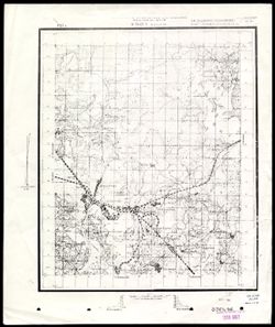
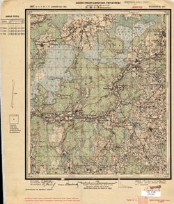
-
- Description:
- 1927
- Subject:
- Geographic Subject: Nelidovo, Topical Subject: Soviet Union, and Topical Subject: Maps
- Publisher:
- Военно-топографическое управление
- Language:
- Russian
- Identifier:
- VAC9619-003499
- Genre:
- Military Maps and Topographic Maps
- Geographic Location:
- Coordinates: 56.167, 32.75, 56.333, 33
- Related URL:
- Download GeoTIFF: https://drive.google.com/file/d/1lyldTXRTAWh4xkvxGY4qHYiAm3I1vIe8/view?usp=sharing and Catalog URL: http://iucat.iu.edu/catalog/5020131
- Abstract:
- Modern area represented: Нелидово (Nelidovo), Tverskaya oblast, Russia
- Call Number:
- G7000 s50 .S68 sheet O-36-138-B
- Caption:
- Секретно
- City:
- Нелидово (Nelidovo)
- Copyright Holder:
- No Copyright - United States
- Country:
- СССР (USSR)
- State/Province:
- РСФСР (RSFSR) and Западная область (Western oblast)
- Physical Description:
- Scale: 1:50,000
- Persistent URL:
- http://purl.dlib.indiana.edu/iudl/images/VAC9619/VAC9619-003499
- Provenance:
- Army Map Service Library, OMAHA, Library of Congress Geography & Map Division
-
- Description:
- 1927
- Subject:
- Topical Subject: Soviet Union, Geographic Subject: Shoptovo, and Topical Subject: Maps
- Publisher:
- Военно-топографическое управление
- Language:
- Russian
- Identifier:
- VAC9619-003504
- Genre:
- Topographic Maps and Military Maps
- Geographic Location:
- Coordinates: 56.0, 33.0, 56.16667, 33.25
- Related URL:
- Catalog URL: http://iucat.iu.edu/catalog/5020131 and Download GeoTIFF: https://drive.google.com/file/d/1jBZ7c8YBwoL20pu6vc6Qs9-_gZvQX4Sd/view?usp=sharing
- Abstract:
- Modern area represented: Шоптово (Shoptovo), Tverskaya oblast, Russia
- Call Number:
- GM G7000 s50 .S68 sheet O-36-139-C
- City:
- Шопотово (Shopotovo)
- Copyright Holder:
- No Copyright - United States
- Country:
- СССР (USSR)
- State/Province:
- РСФСР (RSFSR) and Западная область (Western oblast)
- Physical Description:
- Scale: 1:50,000
- Persistent URL:
- http://purl.dlib.indiana.edu/iudl/images/VAC9619/VAC9619-003504
- Provenance:
- CIA Map Library
-
- Description:
- 1927
- Subject:
- Topical Subject: Maps, Geographic Subject: Tyntsy, and Topical Subject: Soviet Union
- Publisher:
- Управление военных топографов РККА
- Language:
- Russian
- Identifier:
- VAC9619-002272
- Genre:
- Military Maps and Topographic Maps
- Geographic Location:
- Coordinates: 56.3333, 40.5, 56.6667, 41
- Related URL:
- Download GeoTIFF: https://drive.google.com/file/d/102D4vu1uG3HlLnspP2zmEKvXMZnMEkAk/view?usp=sharing and Catalog URL: https://iucat.iu.edu/catalog/5020129
- Abstract:
- Modern area represented: Тынцы (Tyntsy), Vladimirskaya oblast, Russia
- Call Number:
- G7000 s100 .S7 sheet O-37-130
- City:
- Тынцы (Tyntsy)
- Copyright Holder:
- No Copyright - United States
- Country:
- СССР (USSR)
- State/Province:
- РСФСР (RSFSR) and Ивановская область (Ivanovo oblast)
- Physical Description:
- Scale: 1:100,000
- Persistent URL:
- http://purl.dlib.indiana.edu/iudl/images/VAC9619/VAC9619-002272
- Provenance:
- DMA Topographic Center, Army Map Service Library
-
- Description:
- 1927
- Subject:
- Topical Subject: Maps, Topical Subject: Soviet Union, and Geographic Subject: Shchuchye
- Publisher:
- Военно-топографическое управление
- Language:
- Russian
- Identifier:
- VAC9619-001198
- Genre:
- Military Maps and Topographic Maps
- Geographic Location:
- Coordinates: 55.6667, 32, 55.8333, 32.25
- Related URL:
- Download GeoTIFF: https://drive.google.com/open?id=147RGpw0Na2siN-y2rk7SMsc9WXSSvCjn and Catalog URL: http://iucat.iu.edu/catalog/5020131
- Abstract:
- Modern area represented: Shchuchye, Tver oblast, Russia
- Call Number:
- GM G7000 S50 .S68 N-36-5-B
- Caption:
- Секретно
- City:
- Щучье (Shchuchye)
- Copyright Holder:
- No Copyright - United States
- Country:
- СССР (USSR)
- State/Province:
- Западная область (Western oblast) and РСФСР (RSFSR)
- Physical Description:
- Scale: 1:50,000
- Persistent URL:
- http://purl.dlib.indiana.edu/iudl/images/VAC9619/VAC9619-001198
- Provenance:
- Library of Congress Geography & Map Division
-
- Description:
- 1929
- Subject:
- Geographic Subject: Kamenka, Topical Subject: Soviet Union, and Topical Subject: Maps
- Publisher:
- Военно-топографическое управление
- Language:
- Russian
- Identifier:
- VAC9619-003544
- Genre:
- Topographic Maps and Military Maps
- Geographic Location:
- Coordinates: 57.167, 31, 57.333, 31.25
- Related URL:
- Download GeoTIFF: https://drive.google.com/file/d/1lmBNnLm3Poz1CI8n_BfSwm8NcQNlU4M-/view?usp=sharing and Catalog URL: http://iucat.iu.edu/catalog/5020131
- Abstract:
- Modern area represented: Каменка (Kamenka), Novgorodskaya oblast, Russia
- Call Number:
- GM G7000 s50 .S68 sheet O-36-99-A
- Caption:
- Не подлежит оглашению
- City:
- Каменка (Kamenka)
- Copyright Holder:
- No Copyright - United States
- Country:
- СССР (USSR)
- State/Province:
- РСФСР (RSFSR), Западная область (Western oblast), and Ленинградская область (Leningrad oblast)
- Physical Description:
- Scale: 1:50,000
- Persistent URL:
- http://purl.dlib.indiana.edu/iudl/images/VAC9619/VAC9619-003544
- Provenance:
- DMA Topographic Center, Army Map Service Library, Library of Congress Geography & Map Division
-
- Description:
- 1927
- Subject:
- Topical Subject: Soviet Union, Topical Subject: Maps, and Geographic Subject: Tarzhepol'
- Publisher:
- Главное геодезическое управление
- Language:
- Russian
- Identifier:
- VAC9619-002556
- Genre:
- Topographic Maps and Military Maps
- Geographic Location:
- Coordinates: 61, 34, 61.333, 34.5
- Related URL:
- Catalog URL: https://iucat.iu.edu/catalog/5020129 and Download GeoTIFF: https://drive.google.com/file/d/1znEaZC6LKaPd3LRQXlzjNsGvDf9zhkGm/view?usp=sharing
- Abstract:
- Modern area represented: Таржеполь (Tarzhepol’), Republic of Karelia, Russia
- Call Number:
- G7000 s100 .S7 sheet P-36-105
- Caption:
- Не подлежит оглашению
- City:
- Таржеполь (Tarzhepol’)
- Copyright Holder:
- No Copyright - United States
- Country:
- СССР (USSR)
- State/Province:
- Ленинградская область (Leningrad oblast), РСФСР (RSFSR), and Карельская АССР (Karelian Autonomous Soviet Socialist Republic)
- Physical Description:
- Scale: 1:100,000
- Persistent URL:
- http://purl.dlib.indiana.edu/iudl/images/VAC9619/VAC9619-002556
- Provenance:
- DMA Topographic Center, Army Map Service Library, OMAHA
-
- Description:
- 1924
- Subject:
- Topical Subject: Maps, Geographic Subject: Makeyevskaya, and Topical Subject: Soviet Union
- Publisher:
- Генеральный штаб РККА
- Language:
- Russian
- Identifier:
- VAC9619-001307
- Genre:
- Topographic Maps and Military Maps
- Geographic Location:
- Coordinates: 54.833, 32.5, 55, 32.75
- Related URL:
- Download GeoTIFF: https://drive.google.com/open?id=1DEFCkvmGHh4AH9ZIP62l6ti-aIoTcev5 and Catalog URL: http://iucat.iu.edu/catalog/5020131
- Abstract:
- Modern area represented: Makeyevskaya, Smolensk oblast, Russia
- Call Number:
- GM G7000 S50 .S68 N-36-42-A
- Caption:
- Не подлежит оглашению,Рассекречено
- City:
- Макеево (Makeyevo)
- Copyright Holder:
- No Copyright - United States
- Country:
- СССР (USSR)
- State/Province:
- Смоленская область (Smolensk oblast) and РСФСР (RSFSR)
- Physical Description:
- Scale: 1:50,000
- Persistent URL:
- http://purl.dlib.indiana.edu/iudl/images/VAC9619/VAC9619-001307
- Provenance:
- DMA Topographic Center, Army Map Service Library, OMAHA, Library of Congress Geography & Map Division
-
- Description:
- 1924
- Subject:
- Topical Subject: Soviet Union, Topical Subject: Maps, and Geographic Subject: Klemyatino
- Publisher:
- Военно-топографическое управление
- Language:
- Russian
- Identifier:
- VAC9619-001310
- Genre:
- Military Maps and Topographic Maps
- Geographic Location:
- Coordinates: 54.667, 32.75, 54.833, 33
- Related URL:
- Catalog URL: http://iucat.iu.edu/catalog/5020131 and Download GeoTIFF: https://drive.google.com/open?id=1_GQ1ezPewXtI-Cyoge3d6wxuomHbz0i-
- Abstract:
- Modern area represented: Klemyatino, Smolensk oblast, Russia
- Call Number:
- GM G7000 S50 .S68 N-36-42-D
- Caption:
- Секретно
- City:
- Клемятино (Klemyatino)
- Copyright Holder:
- No Copyright - United States
- Country:
- СССР (USSR)
- State/Province:
- Западная область (Western oblast) and РСФСР (RSFSR)
- Physical Description:
- Scale: 1:50,000
- Persistent URL:
- http://purl.dlib.indiana.edu/iudl/images/VAC9619/VAC9619-001310
- Provenance:
- DMA Topographic Center, Army Map Service Library, OMAHA, Library of Congress Geography & Map Division
-
- Description:
- 1924
- Subject:
- Topical Subject: Maps, Topical Subject: Soviet Union, and Geographic Subject: Bologoye
- Publisher:
- Главное геодезическое управление
- Language:
- Russian
- Identifier:
- VAC9619-003526
- Genre:
- Military Maps and Topographic Maps
- Geographic Location:
- Coordinates: 57.83333, 34.0, 58.0, 34.25
- Related URL:
- Download GeoTIFF: https://drive.google.com/file/d/1lKo1upa-fCEH_6HHmrxRE5MEUJX84ipc/view?usp=sharing and Catalog URL: http://iucat.iu.edu/catalog/5020131
- Abstract:
- Modern area represented: Бологое (Bologoye), Tverskaya oblast, Russia
- Call Number:
- GM G7000 s50 .S68 sheet O-36-81-A
- Caption:
- Не подлежит оглашению
- City:
- Бологое (Bologoye)
- Copyright Holder:
- No Copyright - United States
- Country:
- СССР (USSR)
- State/Province:
- РСФСР (RSFSR) and Ленинградская область (Leningrad oblast)
- Physical Description:
- Scale: 1:50,000
- Persistent URL:
- http://purl.dlib.indiana.edu/iudl/images/VAC9619/VAC9619-003526
- Provenance:
- CIA Map Library
-
- Description:
- 1937
- Subject:
- Topical Subject: Maps, Topical Subject: Soviet Union, and Geographic Subject: Chudovo
- Publisher:
- Главное управление государственной съемки и картографии НКВД СССР
- Language:
- Russian
- Identifier:
- VAC9619-003321
- Genre:
- Military Maps and Topographic Maps
- Geographic Location:
- Coordinates: 59, 31.5, 59.167, 31.75
- Related URL:
- Catalog URL: http://iucat.iu.edu/catalog/5020131 and Download GeoTIFF: https://drive.google.com/file/d/1qu9G49EbXKaMk0Aoq4g6yUSWRd9h51WO/view?usp=sharing
- Abstract:
- Modern area represented: Чудово (Chudovo), Novgorodskaya oblast, Russia
- Call Number:
- G7000 s50 .S68 sheet O-36-28-C
- Caption:
- Для служебного пользования and Captured map
- City:
- Чудово (Chudovo)
- Copyright Holder:
- No Copyright - United States
- Country:
- СССР (USSR)
- State/Province:
- РСФСР (RSFSR), Чудовский район (Chudovsky district), and Ленинградская область (Leningrad oblast)
- Physical Description:
- Scale: 1:50,000
- Persistent URL:
- http://purl.dlib.indiana.edu/iudl/images/VAC9619/VAC9619-003321
- Provenance:
- DMA Topographic Center, Army Map Service Library, OMAHA, Library of Congress Geography & Map Division
-
- Subject:
- Geographic Subject: Zarya, Topical Subject: Soviet Union, and Topical Subject: Maps
- Publisher:
- Генеральный штаб РККА
- Language:
- Russian
- Identifier:
- VAC9619-002494
- Genre:
- Topographic Maps and Military Maps
- Geographic Location:
- Coordinates: 62.667, 31.5, 63, 32
- Related URL:
- Catalog URL: https://iucat.iu.edu/catalog/5020129 and Download GeoTIFF: https://drive.google.com/file/d/1rRLTjbTB0wOHfFtdkBF5Ln7yeMTWINlC/view?usp=sharing
- Abstract:
- Modern area represented: Заря (Zarya), Republic of Karelia, Russia
- Call Number:
- G7000 s100 .S7 sheet P-36-40
- Caption:
- Не подлежит оглашению,Captured map
- City:
- Свиная Гора (Svinaya Gora)
- Copyright Holder:
- No Copyright - United States
- Country:
- Финляндия (Finland) and СССР (USSR)
- State/Province:
- РСФСР (RSFSR) and Карельская АССР (Karelian Autonomous Soviet Socialist Republic)
- Physical Description:
- Scale: 1:100,000
- Persistent URL:
- http://purl.dlib.indiana.edu/iudl/images/VAC9619/VAC9619-002494
- Provenance:
- DMA Topographic Center, Army Map Service Library, OMAHA
-
- Description:
- 1937
- Subject:
- Geographic Subject: Menyusha, Topical Subject: Maps, and Topical Subject: Soviet Union
- Publisher:
- Главное управление государственной съемки и картографии НКВД СССР
- Language:
- Russian
- Identifier:
- VAC9619-003364
- Genre:
- Topographic Maps and Military Maps
- Geographic Location:
- Coordinates: 58.333, 30.5, 58.5, 30.75
- Related URL:
- Catalog URL: http://iucat.iu.edu/catalog/5020131 and Download GeoTIFF: https://drive.google.com/file/d/1IDU8_lKnWcG2kljyRcctukOmFczGuoP5/view?usp=sharing
- Abstract:
- Modern area represented: Менюша (Menyusha), Novgorodskaya oblast, Russia
- Call Number:
- G7000 s50 .S68 sheet O-36-50-C
- Caption:
- Captured map and Для служебного пользования
- City:
- Менюши (Menyushi)
- Copyright Holder:
- No Copyright - United States
- Country:
- СССР (USSR)
- State/Province:
- РСФСР (RSFSR), Новгородский район (Novgorod district), Батецкий район (Batetsky district), Ленинградская область (Leningrad oblast), and Шимский район (Shims...
- Physical Description:
- Scale: 1:50,000
- Persistent URL:
- http://purl.dlib.indiana.edu/iudl/images/VAC9619/VAC9619-003364
- Provenance:
- DMA Topographic Center, Army Map Service Library, OMAHA, Library of Congress Geography & Map Division
-
- Description:
- 1927
- Subject:
- Topical Subject: Maps and Topical Subject: Soviet Union
- Publisher:
- Военно-топографическое управление
- Language:
- Russian
- Identifier:
- VAC9619-001194
- Genre:
- Topographic Maps and Military Maps
- Geographic Location:
- Coordinates: 55.6667, 31.5, 55.8333, 31.75
- Related URL:
- Catalog URL: http://iucat.iu.edu/catalog/5020131 and Download GeoTIFF: https://drive.google.com/open?id=18ng3Ha-DW463QtUgByL-39NyU8ttBktM
- Abstract:
- Modern area represented: Tver oblast, Russia
- Call Number:
- GM G7000 S50 .S68 N-36-4-B
- Caption:
- Секретно
- City:
- Березьково (Berezkovo)
- Copyright Holder:
- No Copyright - United States
- Country:
- СССР (USSR)
- State/Province:
- Ленинградская область (Leningrad oblast) and РСФСР (RSFSR)
- Physical Description:
- Scale: 1:50,000
- Persistent URL:
- http://purl.dlib.indiana.edu/iudl/images/VAC9619/VAC9619-001194
- Provenance:
- Geographic Names Branch, Library of Congress Geography & Map Division
-
- Subject:
- Topical Subject: Maps, Geographic Subject: Koskolovo, and Topical Subject: Soviet Union
- Publisher:
- Генеральный штаб РККА
- Language:
- Russian
- Identifier:
- VAC9619-002117
- Genre:
- Topographic Maps and Military Maps
- Geographic Location:
- Coordinates: 59.66667, 28.0, 60.0, 28.5
- Related URL:
- Catalog URL: https://iucat.iu.edu/catalog/5020129 and Download GeoTIFF: https://drive.google.com/open?id=1g9NfQD5xIemlWxnSzIoOSvC68VwCV3ON
- Abstract:
- Modern area represented: Koskolovo, Russia
- Call Number:
- G7000 s100 .S7 sheet O-35-9
- Caption:
- Не подлежит оглашению,Captured map
- City:
- Косколово (Koskolovo)
- Copyright Holder:
- No Copyright - United States
- Country:
- СССР (USSR)
- State/Province:
- РСФСР (RSFSR) and Ленинградская область (Leningrad oblast)
- Physical Description:
- Scale: 1:100,000
- Persistent URL:
- http://purl.dlib.indiana.edu/iudl/images/VAC9619/VAC9619-002117
- Provenance:
- DMA Topographic Center, Library of Congress G & M Division
-
- Description:
- 1937
- Subject:
- Geographic Subject: Pustoshka, Topical Subject: Soviet Union, and Topical Subject: Maps
- Publisher:
- Генеральный штаб РККА
- Language:
- Russian
- Identifier:
- VAC9619-003212
- Genre:
- Military Maps and Topographic Maps
- Geographic Location:
- Coordinates: 56.333, 29, 56.667, 29.5
- Related URL:
- Catalog URL: https://iucat.iu.edu/catalog/5020129 and Download GeoTIFF: https://drive.google.com/file/d/1IvTgPoVX4qW5U4_7tfyvsRijFDiYBQId/view?usp=sharing
- Abstract:
- Modern area represented: Пустошка (Pustoshka), Pskovskaya oblast, Russia
- Call Number:
- G7000 s100 .S7 sheet O-35-131
- Caption:
- Captured map and Не подлежит оглашению
- City:
- Пустошка (Pustoshka)
- Copyright Holder:
- No Copyright - United States
- Country:
- СССР (USSR)
- State/Province:
- Калининская область (Kalinin oblast) and РСФСР (RSFSR)
- Physical Description:
- Scale: 1:100,000
- Persistent URL:
- http://purl.dlib.indiana.edu/iudl/images/VAC9619/VAC9619-003212
- Provenance:
- DMA Topographic Center, Army Map Service Library, OMAHA
-
- Description:
- 1935
- Subject:
- Geographic Subject: Babya Guba, Topical Subject: Soviet Union, and Topical Subject: Maps
- Publisher:
- Itä-Karjalan kartasto
- Language:
- Russian
- Identifier:
- VAC9619-002619
- Genre:
- Military Maps and Topographic Maps
- Geographic Location:
- Coordinates: 64.333, 30, 64.667, 30.5
- Related URL:
- Download GeoTIFF: https://drive.google.com/file/d/1AA7FyE6sffkeuxva0pcxVZ6e1E7qN4hq/view?usp=sharing and Catalog URL: https://iucat.iu.edu/catalog/5020129
- Abstract:
- Modern area represented: Babya Guba, Republic of Karelia, Russia
- Call Number:
- G7000 s100 .S7 sheet Q-36-121
- City:
- Бабья Губа (Babya Guba)
- Copyright Holder:
- No Copyright - United States
- Country:
- СССР (USSR)
- State/Province:
- РСФСР (RSFSR) and Карельская АССР (Karelian Autonomous Soviet Socialist Republic)
- Physical Description:
- Scale: 1:100,000
- Persistent URL:
- http://purl.dlib.indiana.edu/iudl/images/VAC9619/VAC9619-002619
- Provenance:
- DMA Topographic Center, Army Map Service Library, OMAHA
-
- Description:
- 1927
- Subject:
- Geographic Subject: Repino, Topical Subject: Soviet Union, and Topical Subject: Maps
- Publisher:
- Военно-топографическое управление
- Language:
- Russian
- Identifier:
- VAC9619-001237
- Genre:
- Topographic Maps and Military Maps
- Geographic Location:
- Coordinates: 55.333, 32.75, 55.5, 33
- Related URL:
- Download GeoTIFF: https://drive.google.com/open?id=1ZxdMTNgRfAuRlatKqeft1nPgcMH7aszS and Catalog URL: http://iucat.iu.edu/catalog/5020131
- Abstract:
- Modern area represented: Repino, Smolensk oblast, Russia
- Call Number:
- GM G7000 S50 .S68 N-36-18-D
- Caption:
- Секретно
- City:
- Репино (Repino)
- Copyright Holder:
- No Copyright - United States
- Country:
- СССР (USSR)
- State/Province:
- РСФСР (RSFSR) and Западная область (Western oblast)
- Physical Description:
- Scale: 1:50,000
- Persistent URL:
- http://purl.dlib.indiana.edu/iudl/images/VAC9619/VAC9619-001237
- Provenance:
- DMA Topographic Center, Army Map Service Library, Library of Congress Geography & Map Division
-
- Description:
- 1932
- Subject:
- Topical Subject: Soviet Union, Topical Subject: Maps, and Geographic Subject: Zapolye
- Publisher:
- Управление военных топографов
- Language:
- Russian
- Identifier:
- VAC9619-000056
- Genre:
- Topographic Maps and Military Maps
- Geographic Location:
- Coordinates: 57.3333, 30.5, 57.5, 30.75
- Related URL:
- Download GeoTIFF: https://drive.google.com/open?id=17_x28_Z_BDVfOkrBbY4QTkM7htZCIsu8 and Catalog URL: http://iucat.iu.edu/catalog/5020131
- Abstract:
- Modern area represented: Zapolye, Novgorod oblast, Russia
- Call Number:
- G7000 s50 .S68 sheet O-36-86-C
- Caption:
- Не подлежит оглашению
- City:
- Заполье (Zapolye)
- Copyright Holder:
- No Copyright - United States
- Country:
- СССР (USSR)
- State/Province:
- Ленинградская область (Leningrad oblast) and РСФСР (RSFSR)
- Physical Description:
- Scale: 1:50,000
- Persistent URL:
- http://purl.dlib.indiana.edu/iudl/images/VAC9619/VAC9619-000056
- Provenance:
- DMA Topographic Center, Army Map Service Library, OMAHA, Library of Congress Geography & Map Division
-
- Description:
- 1936
- Subject:
- Topical Subject: Maps, Geographic Subject: Novosel'ye, and Topical Subject: Soviet Union
- Publisher:
- Генеральный штаб РККА
- Language:
- Russian
- Identifier:
- VAC9619-002096
- Genre:
- Military Maps and Topographic Maps
- Geographic Location:
- Coordinates: 58, 28.5, 58.3333, 29
- Related URL:
- Catalog URL: https://iucat.iu.edu/catalog/5020129 and Download GeoTIFF: https://drive.google.com/open?id=1TZK4VUwIIVCkEPn2Os1U3q9qu01xXlNy
- Abstract:
- Modern area represented: Новоселье (Novosel'ye), Pskovskaya oblast, Russia
- Call Number:
- G7000 s100 .S7 sheet O-35-70
- Caption:
- Не подлежит оглашению
- City:
- Новоселье (Novosel'ye)
- Copyright Holder:
- No Copyright - United States
- Country:
- СССР (USSR)
- State/Province:
- РСФСР (RSFSR) and Ленинградская область (Leningrad oblast)
- Physical Description:
- Scale: 1:100,000
- Persistent URL:
- http://purl.dlib.indiana.edu/iudl/images/VAC9619/VAC9619-002096
- Provenance:
- DMA Topographic Center, Army Map Service Library, OMAHA, Library of Congress Geography & Map Division, Auswärtiges Amt. Geographischer Dienst
-
- Subject:
- Topical Subject: Maps, Geographic Subject: Kompakovo, and Topical Subject: Soviet Union
- Publisher:
- Itä-Karjalan kartasto
- Language:
- Russian
- Identifier:
- VAC9619-002627
- Genre:
- Military Maps and Topographic Maps
- Geographic Location:
- Coordinates: 64, 33, 64.333, 33.5
- Related URL:
- Catalog URL: https://iucat.iu.edu/catalog/5020129 and Download GeoTIFF: https://drive.google.com/file/d/1JfsOmHZ42nOsXDVN-rgwIAwDgAaX-C-w/view?usp=sharing
- Abstract:
- Modern area represented: Kompakovo, Republic of Karelia, Russia
- Call Number:
- G7000 s100 .S7 sheet Q-36-139
- City:
- Компаково (Kompakovo)
- Copyright Holder:
- No Copyright - United States
- Country:
- СССР (USSR)
- State/Province:
- Карельская АССР (Karelian Autonomous Soviet Socialist Republic) and РСФСР (RSFSR)
- Physical Description:
- Scale: 1:100,000
- Persistent URL:
- http://purl.dlib.indiana.edu/iudl/images/VAC9619/VAC9619-002627
- Provenance:
- DMA Topographic Center, Army Map Service Library, OMAHA
-
- Description:
- 1938
- Subject:
- Topical Subject: Soviet Union, Geographic Subject: Sumskiy Posad, and Topical Subject: Maps
- Publisher:
- Itä-Karjalan kartasto
- Language:
- Russian
- Identifier:
- VAC9619-002628
- Genre:
- Topographic Maps and Military Maps
- Geographic Location:
- Coordinates: 64, 35, 64.333, 35.5
- Related URL:
- Catalog URL: https://iucat.iu.edu/catalog/5020129 and Download GeoTIFF: https://drive.google.com/file/d/1os2-CTkeLt1ja44b0AJXS7uQmKjqEaOF/view?usp=sharing
- Abstract:
- Modern area represented: Sumskiy Posad, Republic of Karelia, Russia
- Call Number:
- G7000 s100 .S7 sheet Q-36-143
- City:
- Сумский Посад (Sumskiy Posad)
- Copyright Holder:
- No Copyright - United States
- Country:
- СССР (USSR)
- State/Province:
- РСФСР (RSFSR), Карельская АССР (Karelian Autonomous Soviet Socialist Republic), and Беломорский район (Belomorskiy district)
- Physical Description:
- Scale: 1:100,000
- Persistent URL:
- http://purl.dlib.indiana.edu/iudl/images/VAC9619/VAC9619-002628
- Provenance:
- DMA Topographic Center, Army Map Service Library, OMAHA, Geographic Names Branch, Atlasblatt
-
- Description:
- 1937
- Subject:
- Geographic Subject: Rusynya, Topical Subject: Soviet Union, and Topical Subject: Maps
- Publisher:
- Генеральный штаб РККА
- Language:
- Russian
- Identifier:
- VAC9619-003358
- Genre:
- Topographic Maps and Military Maps
- Geographic Location:
- Coordinates: 58.5, 30, 58.667, 30.25
- Related URL:
- Catalog URL: http://iucat.iu.edu/catalog/5020131 and Download GeoTIFF: https://drive.google.com/file/d/1y0UWGCUrQHdjLPGe_0L1X40nbLkBnx1V/view?usp=sharing
- Abstract:
- Modern area represented: Русыня (Rusynya), Novgorodskaya oblast, Russia
- Call Number:
- G7000 s50 .S68 sheet O-36-6-B
- Caption:
- Не подлежит оглашению and Captured map
- City:
- Русыня (Rusynya)
- Copyright Holder:
- No Copyright - United States
- Country:
- СССР (USSR)
- State/Province:
- Ленинградская область (Leningrad oblast) and РСФСР (RSFSR)
- Physical Description:
- Scale: 1:50,000
- Persistent URL:
- http://purl.dlib.indiana.edu/iudl/images/VAC9619/VAC9619-003358
- Provenance:
- Army Map Service Library, OMAHA
-
- Description:
- 1935
- Subject:
- Topical Subject: Soviet Union, Geographic Subject: Ondozero, and Topical Subject: Maps
- Publisher:
- Itä-Karjalan kartasto
- Language:
- Russian
- Identifier:
- VAC9619-002474
- Genre:
- Topographic Maps and Military Maps
- Geographic Location:
- Coordinates: 63.667, 33, 64, 33.5
- Related URL:
- Download GeoTIFF: https://drive.google.com/file/d/1G_kLCaKmFqHbXcPnx733qtOiPyZ4YNbr/view?usp=sharing and Catalog URL: https://iucat.iu.edu/catalog/5020129
- Abstract:
- Modern area represented: Ondozero, Republic of Karelia, Russia
- Call Number:
- G7000 s100 .S7 sheet P-36-7
- City:
- Ондозеро (Ondozero)
- Copyright Holder:
- No Copyright - United States
- Country:
- СССР (USSR)
- State/Province:
- Карельская АССР (Karelian Autonomous Soviet Socialist Republic) and РСФСР (RSFSR)
- Physical Description:
- Scale: 1:100,000
- Persistent URL:
- http://purl.dlib.indiana.edu/iudl/images/VAC9619/VAC9619-002474
- Provenance:
- DMA Topographic Center, Army Map Service Library, OMAHA
-
- Description:
- 1926
- Subject:
- Topical Subject: Maps, Topical Subject: Soviet Union, and Geographic Subject: Zubari
- Publisher:
- Военно-топографическое управление
- Language:
- Russian
- Identifier:
- VAC9619-001264
- Genre:
- Topographic Maps and Military Maps
- Geographic Location:
- Coordinates: 55, 31.5, 55.1667, 31.75
- Related URL:
- Download GeoTIFF: https://drive.google.com/open?id=1aYF5UKarF9UXaKGg5aPxZko1gilh3nGB and Catalog URL: http://iucat.iu.edu/catalog/5020131
- Abstract:
- Modern area represented: Zubari, Smolensk oblast, Russia
- Call Number:
- GM G7000 S50 .S68 N-36-28-Б
- Caption:
- Секретно
- City:
- Зубари (Zubari)
- Copyright Holder:
- No Copyright - United States
- Country:
- СССР (USSR)
- State/Province:
- РСФСР (RSFSR) and Западная область (Western oblast)
- Physical Description:
- Scale: 1:50,000
- Persistent URL:
- http://purl.dlib.indiana.edu/iudl/images/VAC9619/VAC9619-001264
- Provenance:
- Army Map Service Library, Library of Congress Geography & Map Division, OMAHA
-
- Description:
- 1936
- Subject:
- Topical Subject: Maps, Geographic Subject: Gverzdon', and Topical Subject: Soviet Union
- Publisher:
- Генеральный штаб РККА
- Language:
- Russian
- Identifier:
- VAC9619-002701
- Genre:
- Topographic Maps and Military Maps
- Geographic Location:
- Coordinates: 58, 28.25, 58.167, 28.5
- Related URL:
- Download GeoTIFF: https://drive.google.com/file/d/1CP-E2i8ApPidjwpZuUS6pyjTpk00XKO4/view?usp=sharing and Catalog URL: http://iucat.iu.edu/catalog/5020131
- Abstract:
- Modern area represented: Гверздонь (Gverzdon'), Псковская область (Pskovskaya oblast), Russia
- Call Number:
- GM G7000 s50 .S68 sheet O-35-69-D
- Caption:
- Не подлежит оглашению and Captured map
- City:
- Гверздонь (Gverzdon')
- Copyright Holder:
- No Copyright - United States
- Country:
- СССР (USSR)
- State/Province:
- Ленинградская область (Leningrad oblast) and РСФСР (RSFSR)
- Physical Description:
- Scale: 1:50,000
- Persistent URL:
- http://purl.dlib.indiana.edu/iudl/images/VAC9619/VAC9619-002701
- Provenance:
- Army Map Service Library, OMAHA, Library of Congress Geography & Map Division
-
- Description:
- 1927
- Subject:
- Topical Subject: Soviet Union, Geographic Subject: Mezheninka, and Topical Subject: Maps
- Publisher:
- Военно-топографическое управление
- Language:
- Russian
- Identifier:
- VAC9619-003502
- Genre:
- Military Maps and Topographic Maps
- Geographic Location:
- Coordinates: 56.16667, 33.0, 56.3333, 33.25
- Related URL:
- Catalog URL: http://iucat.iu.edu/catalog/5020131 and Download GeoTIFF: https://drive.google.com/file/d/1msDwvef1CncSNMwEPY6URhxcHpecNCQ8/view?usp=sharing
- Abstract:
- Modern area represented: Меженинка (Mezheninka), Tverskaya oblast, Russia
- Call Number:
- GM G7000 s50 .S68 sheet O-36-139-A
- City:
- Межененские (Mezhenenskiye)
- Copyright Holder:
- No Copyright - United States
- Country:
- СССР (USSR)
- State/Province:
- РСФСР (RSFSR) and Западная область (Western oblast)
- Physical Description:
- Scale: 1:50,000
- Persistent URL:
- http://purl.dlib.indiana.edu/iudl/images/VAC9619/VAC9619-003502
- Provenance:
- DMA Topographic Center, Army Map Service Library, OMAHA, Library of Congress Geography & Map Division
-
- Description:
- 1937
- Subject:
- Topical Subject: Soviet Union, Geographic Subject: Radocha, and Topical Subject: Maps
- Publisher:
- Главное управление государственной съемки и картографии НКВД СССР
- Language:
- Russian
- Identifier:
- VAC9619-003349
- Genre:
- Military Maps and Topographic Maps
- Geographic Location:
- Coordinates: 58.667, 31.75, 58.833, 32
- Related URL:
- Download GeoTIFF: https://drive.google.com/file/d/1ZNHMDAQawaHv8k6lAQzvW3K6VJoZr6nP/view?usp=sharing and Catalog URL: http://iucat.iu.edu/catalog/5020131
- Abstract:
- Modern area represented: Радоча (Radocha), Novgorodskaya oblast, Russia
- Call Number:
- G7000 s50 .S68 sheet O-36-40-D
- Caption:
- Для служебного пользования
- City:
- Радоча (Radocha)
- Copyright Holder:
- No Copyright - United States
- Country:
- СССР (USSR)
- State/Province:
- Новгородский район (Novgorod district), Ленинградская область (Leningrad oblast), Чудовский район (Chudovsky district), Маловишерский район (Malovishersky di...
- Physical Description:
- Scale: 1:50,000
- Persistent URL:
- http://purl.dlib.indiana.edu/iudl/images/VAC9619/VAC9619-003349
- Provenance:
- Army Map Service Library, Library of Congress Geography & Map Division
-
- Description:
- 1937
- Subject:
- Topical Subject: Maps, Topical Subject: Soviet Union, and Geographic Subject: Karamyshevo
- Publisher:
- Генеральный штаб РККА
- Language:
- Russian
- Identifier:
- VAC9619-002809
- Genre:
- Military Maps and Topographic Maps
- Geographic Location:
- Coordinates: 57.667, 28.75, 57.833, 29
- Related URL:
- Catalog URL: http://iucat.iu.edu/catalog/5020131 and Download GeoTIFF: https://drive.google.com/file/d/1JImzUSmwzN59vUFeQ-Jrq0P4f-x20KsC/view?usp=sharing
- Abstract:
- Modern area represented: Карамышево (Karamyshevo), Псковская область (Pskovskaya oblast), Russia
- Call Number:
- GM G7000 s50 .S68 sheet O-35-82-D
- Caption:
- Не подлежит оглашению and Captured map
- City:
- Карамышево (Karamyshevo)
- Copyright Holder:
- No Copyright - United States
- Country:
- СССР (USSR)
- State/Province:
- РСФСР (RSFSR) and Ленинградская область (Leningrad oblast)
- Physical Description:
- Scale: 1:50,000
- Persistent URL:
- http://purl.dlib.indiana.edu/iudl/images/VAC9619/VAC9619-002809
- Provenance:
- Army Map Service Library, OMAHA, Library of Congress Geography & Map Division
-
- Description:
- 1934
- Subject:
- Topical Subject: Soviet Union, Topical Subject: Maps, and Geographic Subject: Semchozero
- Publisher:
- Itä-Karjalan kartasto
- Language:
- Russian
- Identifier:
- VAC9619-002498
- Genre:
- Military Maps and Topographic Maps
- Geographic Location:
- Coordinates: 62.667, 33.5, 63, 34
- Related URL:
- Catalog URL: https://iucat.iu.edu/catalog/5020129 and Download GeoTIFF: https://drive.google.com/file/d/1oN694nczXdITJS_gTb_BqX-r1cs9UY6u/view?usp=sharing
- Abstract:
- Modern area represented: Semchozero, Republic of Karelia, Russia
- Call Number:
- G7000 s100 .S7 sheet P-36-44
- City:
- Семчозеро (Semchozero)
- Copyright Holder:
- No Copyright - United States
- Country:
- СССР (USSR)
- State/Province:
- Карельская АССР (Karelian Autonomous Soviet Socialist Republic) and РСФСР (RSFSR)
- Physical Description:
- Scale: 1:100,000
- Persistent URL:
- http://purl.dlib.indiana.edu/iudl/images/VAC9619/VAC9619-002498
- Provenance:
- DMA Topographic Center, Army Map Service Library, OMAHA
-
- Description:
- 1927
- Subject:
- Topical Subject: Soviet Union, Geographic Subject: Kovali, and Topical Subject: Maps
- Publisher:
- Управление военных топографов
- Language:
- Russian
- Identifier:
- VAC9619-003494
- Genre:
- Topographic Maps and Military Maps
- Geographic Location:
- Coordinates: 56.0, 31.75, 56.16667, 32.0
- Related URL:
- Download GeoTIFF: https://drive.google.com/file/d/1aUs01744U8z9WJUyVwJHJ7uEfI1G5EIX/view?usp=sharing and Catalog URL: http://iucat.iu.edu/catalog/5020131
- Abstract:
- Modern area represented: Ковали (Kovali), Tverskaya oblast, Russia
- Call Number:
- G7000 s50 .S68 sheet O-36-136-D
- Caption:
- Не подлежит оглашению
- City:
- Ковали (Kovali)
- Copyright Holder:
- No Copyright - United States
- Country:
- СССР (USSR)
- State/Province:
- РСФСР (RSFSR) and Западная область (Western oblast)
- Physical Description:
- Scale: 1:50,000
- Persistent URL:
- http://purl.dlib.indiana.edu/iudl/images/VAC9619/VAC9619-003494
- Provenance:
- M. I. Map Library
-
- Description:
- 1941
- Subject:
- Topical Subject: Soviet Union, Geographic Subject: Ostrogozhsk, and Topical Subject: Maps
- Publisher:
- Генеральный штаб Красной Армии
- Language:
- Russian
- Identifier:
- VAC9619-003384
- Genre:
- Topographic Maps and Military Maps
- Geographic Location:
- Coordinates: 50.667, 39, 51, 39.5
- Related URL:
- Catalog URL: https://iucat.iu.edu/catalog/5020129 and Download GeoTIFF: https://drive.google.com/file/d/1mEa6VsLQ-QS3Ro98p9AFIYAvBABMRTLL/view?usp=sharing
- Abstract:
- Modern area represented: Ostrogozhsk, Voronezh oblast, Russia
- Call Number:
- G7000 s100 .S7 sheet M-37-43
- Caption:
- Для служебного пользования
- City:
- Острогожск (Ostrogozhsk)
- Copyright Holder:
- No Copyright - United States
- Country:
- СССР (USSR)
- State/Province:
- РСФСР (RSFSR) and Воронежская область (Voronezh oblast)
- Physical Description:
- Scale: 1:100,000
- Persistent URL:
- http://purl.dlib.indiana.edu/iudl/images/VAC9619/VAC9619-003384
- Provenance:
- DMA Topographic Center, Army Map Service Library, OMAHA, Library of Congress Geography & Map Division
-
- Description:
- 1935
- Subject:
- Geographic Subject: Novaya Tayga, Topical Subject: Maps, and Topical Subject: Soviet Union
- Publisher:
- Управление военных топографов РККА
- Language:
- Russian
- Identifier:
- VAC9619-002582
- Genre:
- Military Maps and Topographic Maps
- Geographic Location:
- Coordinates: 44.333, 135, 44.667, 135.5
- Related URL:
- Catalog URL: https://iucat.iu.edu/catalog/5020129 and Download GeoTIFF: https://drive.google.com/file/d/1RIcE94wbwyxP1PKoJIbffVis3GXkqE93/view?usp=sharing
- Abstract:
- Modern area represented: Novaya Tayga, Primorsky kray, Russia
- Call Number:
- G7000 s100 .S7 sheet L-53-127
- Caption:
- Не подлежит оглашению
- City:
- Новая Тайга (Novaya Tayga)
- Copyright Holder:
- No Copyright - United States
- Country:
- СССР (USSR)
- State/Province:
- РСФСР (RSFSR) and Дальневосточный край (Far Eastern kray)
- Physical Description:
- Scale: 1:100,000
- Persistent URL:
- http://purl.dlib.indiana.edu/iudl/images/VAC9619/VAC9619-002582
- Provenance:
- CIA Map Library, Library of Congress Geography & Map Division, Atlasblatt
-
- Description:
- 1929
- Subject:
- Geographic Subject: Krasnyy Bor, Topical Subject: Maps, and Topical Subject: Soviet Union
- Publisher:
- Военно-топографическое управление
- Language:
- Russian
- Identifier:
- VAC9619-002878
- Genre:
- Military Maps and Topographic Maps
- Geographic Location:
- Coordinates: 56.833, 30.75, 57, 31
- Related URL:
- Download GeoTIFF: https://drive.google.com/file/d/1tRP6vA30sltgAeBoQYIW9qfHTR-CT4XL/view?usp=sharing and Catalog URL: http://iucat.iu.edu/catalog/5020131
- Abstract:
- Modern area represented: Красный Бор (Krasnyy Bor), Novgorodskaya oblast, Russia
- Call Number:
- GM G7000 s50 .S68 sheet O-36-100-B
- City:
- Поколоты (Pokoloty)
- Copyright Holder:
- No Copyright - United States
- Country:
- СССР (USSR)
- State/Province:
- Западная область (Western oblast) and РСФСР (RSFSR)
- Physical Description:
- Scale: 1:50,000
- Persistent URL:
- http://purl.dlib.indiana.edu/iudl/images/VAC9619/VAC9619-002878
- Provenance:
- DMA Topographic Center, Army Map Service Library, OMAHA, Library of Congress Geography & Map Division
-
- Description:
- 1941
- Subject:
- Topical Subject: Maps, Topical Subject: Soviet Union, and Geographic Subject: Krasnoye
- Publisher:
- Генеральный штаб Красной Армии
- Language:
- Russian
- Identifier:
- VAC9619-003069
- Genre:
- Topographic Maps and Military Maps
- Geographic Location:
- Coordinates: 52.667, 38.5, 53, 39
- Related URL:
- Download GeoTIFF: https://drive.google.com/file/d/1gGtaMimC-5weHvo8Mw1g8v9DgorhzlVf/view?usp=sharing and Catalog URL: https://iucat.iu.edu/catalog/5020129
- Abstract:
- Modern area represented: Красное (Krasnoye), Lipetskaya oblast, Russia
- Call Number:
- G7000 s100 .S7 sheet N-37-114
- City:
- Красное (Krasnoye)
- Copyright Holder:
- No Copyright - United States
- Country:
- СССР (USSR)
- State/Province:
- Тульская область (Tula oblast), РСФСР (RSFSR), Орловская область (Oryol oblast), Воронежская область (Voronezh oblast), and Рязанская область (Ryazan oblast)
- Physical Description:
- Scale: 1:100,000
- Persistent URL:
- http://purl.dlib.indiana.edu/iudl/images/VAC9619/VAC9619-003069
- Provenance:
- Army Map Service Library, Library of Congress G & M Division
-
- Subject:
- Topical Subject: Maps, Geographic Subject: Pazhilo, and Topical Subject: Soviet Union
- Language:
- Russian
- Identifier:
- VAC9619-000066
- Genre:
- Topographic Maps and Military Maps
- Geographic Location:
- Coordinates: 61.667, 32.25, 61.833, 32.5
- Related URL:
- Download GeoTIFF: https://drive.google.com/open?id=11OfMCa_E44TFwpGOdRsRl1d9twyoNcZQ and Catalog URL: http://iucat.iu.edu/catalog/5020131
- Abstract:
- Modern area represented: Pazhilo, Republic of Karelia, Russia
- Call Number:
- G7000 s50 .S68 sheet P-36-77-G
- City:
- Пажило (Pazhilo)
- Copyright Holder:
- No Copyright - United States
- Country:
- СССР (USSR)
- State/Province:
- Карельская АССР (Karelian Autonomous Soviet Socialist Republic) and РСФСР (RSFSR)
- Physical Description:
- Scale: 1:50,000
- Persistent URL:
- http://purl.dlib.indiana.edu/iudl/images/VAC9619/VAC9619-000066
- Provenance:
- DMA Topographic Center, Army Map Service Library, Library of Congress Geography & Map Division
-
- Description:
- 1937
- Subject:
- Topical Subject: Soviet Union, Topical Subject: Maps, and Geographic Subject: Opukhliki
- Publisher:
- Генеральный штаб РККА
- Language:
- Russian
- Identifier:
- VAC9619-003484
- Genre:
- Topographic Maps and Military Maps
- Geographic Location:
- Coordinates: 56, 30, 56.167, 30.25
- Related URL:
- Download GeoTIFF: https://drive.google.com/file/d/1_e8VIv6WFrIfxi_kOo7Bc_5Tsq8Ppw_P/view?usp=sharing and Catalog URL: http://iucat.iu.edu/catalog/5020131
- Abstract:
- Modern area represented: Опухлики (Opukhliki), Pskovskaya oblast, Russia
- Call Number:
- G7000 s50 .S68 sheet O-36-133-C
- Caption:
- Не подлежит оглашению and Captured map
- City:
- Опухлики (Opukhliki)
- Copyright Holder:
- No Copyright - United States
- Country:
- СССР (USSR)
- State/Province:
- Калининская область (Kalinin oblast) and РСФСР (RSFSR)
- Physical Description:
- Scale: 1:50,000
- Persistent URL:
- http://purl.dlib.indiana.edu/iudl/images/VAC9619/VAC9619-003484
- Provenance:
- Army Map Service Library, OMAHA, Library of Congress Geography & Map Division
-
- Description:
- 1924
- Subject:
- Topical Subject: Maps, Geographic Subject: Novoseltsy, and Topical Subject: Soviet Union
- Publisher:
- Военно-топографическое управление
- Language:
- Russian
- Identifier:
- VAC9619-001298
- Genre:
- Topographic Maps and Military Maps
- Geographic Location:
- Coordinates: 54.833, 31.25, 55, 31.5
- Related URL:
- Download GeoTIFF: https://drive.google.com/open?id=1siLHSbgMm3qfJZoApwmmSp21L-m2P5Qs and Catalog URL: http://iucat.iu.edu/catalog/5020131
- Abstract:
- Modern area represented: Novoseltsy, Smolensk oblast, Russia
- Call Number:
- GM G7000 S50 .S68 N-36-39-Б
- Caption:
- Секретно
- City:
- Новосельцы (Novoseltsy)
- Copyright Holder:
- No Copyright - United States
- Country:
- СССР (USSR)
- State/Province:
- Западная область (Western oblast) and РСФСР (RSFSR)
- Physical Description:
- Scale: 1:50,000
- Persistent URL:
- http://purl.dlib.indiana.edu/iudl/images/VAC9619/VAC9619-001298
- Provenance:
- DMA Topographic Center, Army Map Service Library, OMAHA, Library of Congress Geography & Map Division
-
- Description:
- 1937
- Subject:
- Topical Subject: Maps, Topical Subject: Soviet Union, and Geographic Subject: Olomna
- Publisher:
- Главное управление государственной съемки и картографии НКВД СССР
- Language:
- Russian
- Identifier:
- VAC9619-003011
- Genre:
- Topographic Maps and Military Maps
- Geographic Location:
- Coordinates: 59.5, 31.75, 59.667, 32
- Related URL:
- Download GeoTIFF: https://drive.google.com/file/d/1KLZhvz4VV7m4MqP7OxUfyZwY0ynP_hzS/view?usp=sharing and Catalog URL: http://iucat.iu.edu/catalog/5020131
- Abstract:
- Modern area represented: Olomna, Leningrad oblast, Russia
- Call Number:
- G7000 s50 .S68 sheet O-36-16-B
- Caption:
- Для служебного пользования,Captured map
- City:
- Оломна (Olomna)
- Copyright Holder:
- No Copyright - United States
- Country:
- СССР (USSR)
- State/Province:
- РСФСР (RSFSR), Мгинский район (Mginsky district), Киришский район (Kirishsky district), and Ленинградская область (Leningrad oblast)
- Physical Description:
- Scale: 1:50,000
- Persistent URL:
- http://purl.dlib.indiana.edu/iudl/images/VAC9619/VAC9619-003011
- Provenance:
- DMA Topographic Center, Army Map Service Library, Library of Congress Geography & Map Division
-

- Description:
- 1936
- Subject:
- Geographic Subject: Akhobe, Topical Subject: Maps, and Topical Subject: Soviet Union
- Publisher:
- Управление военных топографов РККА
- Language:
- Russian
- Identifier:
- VAC9619-002591
- Genre:
- Topographic Maps and Military Maps
- Geographic Location:
- Coordinates: 47, 138, 47.333, 138.5
- Related URL:
- Download GeoTIFF: https://drive.google.com/file/d/11zScXf4PWIJnNDJt2g9dgJ4MeiDc8cwa/view?usp=sharing and Catalog URL: https://iucat.iu.edu/catalog/5020129
- Abstract:
- Modern area represented: Akhobe, Primorskiy kray, Russia
- Call Number:
- G7000 s100 .S7 sheet L-54-25
- Caption:
- Не подлежит оглашению
- City:
- Ахобе (Akhobe)
- Copyright Holder:
- No Copyright - United States
- Country:
- СССР (USSR)
- State/Province:
- РСФСР (RSFSR) and Дальневосточный край (Far Eastern kray)
- Physical Description:
- Scale: 1:100,000
- Persistent URL:
- http://purl.dlib.indiana.edu/iudl/images/VAC9619/VAC9619-002591
- Provenance:
- Army Map Service Library
-

- Subject:
- Topical Subject: Soviet Union, Geographic Subject: Zakharovo, and Topical Subject: Maps
- Publisher:
- Управление военных топографов РККА
- Language:
- Russian
- Identifier:
- VAC9619-003479
- Genre:
- Military Maps and Topographic Maps
- Geographic Location:
- Coordinates: 56.167, 30, 56.333, 30.25
- Related URL:
- Download GeoTIFF: https://drive.google.com/file/d/18qVdwAsXlKVJqWQ87u7VFZ3iwvTgaxI9/view?usp=sharing and Catalog URL: http://iucat.iu.edu/catalog/5020131
- Abstract:
- Modern area represented: Захарово (Zakharovo), Tverskaya oblast, Russia
- Call Number:
- G7000 s50 .S68 sheet O-36-133-A
- Caption:
- Не подлежит оглашению
- City:
- Захарова (Zakharova)
- Copyright Holder:
- No Copyright - United States
- Country:
- СССР (USSR)
- State/Province:
- Калининская область (Kalinin oblast) and РСФСР (RSFSR)
- Physical Description:
- Scale: 1:50,000
- Persistent URL:
- http://purl.dlib.indiana.edu/iudl/images/VAC9619/VAC9619-003479
- Provenance:
- M. I. Map Library
-
- Description:
- 1936
- Subject:
- Topical Subject: Maps, Topical Subject: Soviet Union, and Geographic Subject: Novlyanka
- Publisher:
- Управление военных топографов РККА
- Language:
- Russian
- Identifier:
- VAC9619-003071
- Genre:
- Topographic Maps and Military Maps
- Geographic Location:
- Coordinates: 55.667, 41.5, 56, 42
- Related URL:
- Catalog URL: https://iucat.iu.edu/catalog/5020129 and Download GeoTIFF: https://drive.google.com/file/d/1vYAF9-OGoq-YzohM4unbcu0E3ACo48hA/view?usp=sharing
- Abstract:
- Modern area represented: Novlyanka, Vladimir oblast, Russia
- Call Number:
- G7000 s100 .S7 sheet N-37-12
- City:
- Новлянка (Novlyanka)
- Copyright Holder:
- No Copyright - United States
- Country:
- СССР (USSR)
- State/Province:
- РСФСР (RSFSR), Горьковский край (Gorky kray), and Ивановская область (Ivanovo oblast)
- Physical Description:
- Scale: 1:100,000
- Persistent URL:
- http://purl.dlib.indiana.edu/iudl/images/VAC9619/VAC9619-003071
-

- Description:
- 1939
- Subject:
- Topical Subject: Maps, Geographic Subject: Mezhetchina, and Topical Subject: Soviet Union
- Publisher:
- Главное Управление Геодезии и Картографии при СНК СССР
- Language:
- Russian
- Identifier:
- VAC9619-001287
- Genre:
- Topographic Maps and Military Maps
- Geographic Location:
- Coordinates: 55.1667, 35.25, 55.3333, 35.5
- Related URL:
- Download GeoTIFF: https://drive.google.com/open?id=1VS_zfoXjVOcxrcy_I8gzTCE8syzPyL3N and Catalog URL: http://iucat.iu.edu/catalog/5020131
- Abstract:
- Modern area represented: Mezhetchina, Kaluga oblast, Russia
- Call Number:
- GM G7000 S50 .S68 N-36-35-Б
- City:
- Межетчина (Mezhetchina)
- Copyright Holder:
- No Copyright - United States
- Country:
- СССР (USSR)
- State/Province:
- Смоленская область (Smolensk oblast), Московская область (Moscow oblast), and РСФСР (RSFSR)
- Physical Description:
- Scale: 1:50,000
- Persistent URL:
- http://purl.dlib.indiana.edu/iudl/images/VAC9619/VAC9619-001287
- Provenance:
- DMA Topographic Center, Army Map Service Library, OMAHA, Library of Congress Geography & Map Division
-
- Description:
- 1932
- Subject:
- Topical Subject: Soviet Union, Topical Subject: Maps, and Geographic Subject: Sosnitsa
- Publisher:
- Управление военных топографов
- Language:
- Russian
- Identifier:
- VAC9619-003527
- Genre:
- Topographic Maps and Military Maps
- Geographic Location:
- Coordinates: 57.5, 30.25, 57.66667, 30.5
- Related URL:
- Download GeoTIFF: https://drive.google.com/file/d/1otfh7tEJGovjTG1kBgOUSPykGF2A9kj3/view?usp=sharing and Catalog URL: http://iucat.iu.edu/catalog/5020131
- Abstract:
- Modern area represented: Сосница (Sosnitsa), Pskovskaya oblast, Russia
- Call Number:
- GM G7000 s50 .S68 sheet O-36-85-B
- Caption:
- Не подлежит оглашению and Captured map
- City:
- Сосницы (Sosnitsy)
- Copyright Holder:
- No Copyright - United States
- Country:
- СССР (USSR)
- State/Province:
- Ленинградская область (Leningrad oblast) and РСФСР (RSFSR)
- Physical Description:
- Scale: 1:50,000
- Persistent URL:
- http://purl.dlib.indiana.edu/iudl/images/VAC9619/VAC9619-003527
- Provenance:
- Army Map Service Library, OMAHA
-
- Description:
- 1939
- Subject:
- Topical Subject: Soviet Union, Geographic Subject: Vorobyevo, and Topical Subject: Maps
- Publisher:
- Управление военных топографов
- Language:
- Russian
- Identifier:
- VAC9619-001284
- Genre:
- Military Maps and Topographic Maps
- Geographic Location:
- Coordinates: 55.1667, 34.75, 55.3333, 35
- Related URL:
- Download GeoTIFF: https://drive.google.com/open?id=1LayhulUP8SrFFvp-1eSPl0T8NZqOu58p and Catalog URL: http://iucat.iu.edu/catalog/5020131
- Abstract:
- Modern area represented: Vorobyevo, Smolensk oblast, Russia
- Call Number:
- GM G7000 S50 .S68 N-36-34-Б
- City:
- Воробьево (Vorobyevo)
- Copyright Holder:
- No Copyright - United States
- Country:
- СССР (USSR)
- State/Province:
- РСФСР (RSFSR) and Смоленская область (Smolensk oblast)
- Physical Description:
- Scale: 1:50,000
- Persistent URL:
- http://purl.dlib.indiana.edu/iudl/images/VAC9619/VAC9619-001284
- Provenance:
- DMA Topographic Center, Army Map Service Library, Library of Congress Geography & Map Division
-
- Subject:
- Geographic Subject: Krasnapolle, Topical Subject: Soviet Union, and Topical Subject: Maps
- Publisher:
- Генеральный штаб РККА
- Language:
- Russian
- Identifier:
- VAC9619-000428
- Genre:
- Topographic Maps and Military Maps
- Geographic Location:
- Coordinates: 55.6667, 29.25, 55.8333, 29.5
- Related URL:
- Catalog URL: http://iucat.iu.edu/catalog/5020131 and Download GeoTIFF: https://drive.google.com/open?id=1lnFFPfIgSAAmfNYy3K1v2DcWEbI3vPvP
- Abstract:
- Modern area represented: Krasnapolle, Vitebsk oblast, Belarus
- Call Number:
- G7000 s50 .S68 sheet N-35-11-D
- Caption:
- Не подлежит оглашению
- City:
- Краснополье (Krasnopolye)
- Copyright Holder:
- No Copyright - United States
- Country:
- СССР (USSR)
- State/Province:
- РСФСР (RSFSR), Калининская область (Kalinin oblast), Витебская область (Vitebsk oblast), and Белорусская ССР (Byelorussian Soviet Socialist Republic)
- Physical Description:
- Scale: 1:50,000
- Persistent URL:
- http://purl.dlib.indiana.edu/iudl/images/VAC9619/VAC9619-000428
- Provenance:
- M. I. Map Library, G000-30, GS, RA
-
- Description:
- 1937
- Subject:
- Geographic Subject: Koshelevo, Topical Subject: Soviet Union, and Topical Subject: Maps
- Publisher:
- Генеральный штаб РККА
- Language:
- Russian
- Identifier:
- VAC9619-001180
- Genre:
- Topographic Maps and Military Maps
- Geographic Location:
- Coordinates: 55.8333, 30, 56, 30.25
- Related URL:
- Catalog URL: http://iucat.iu.edu/catalog/5020131 and Download GeoTIFF: https://drive.google.com/open?id=1fvQPflRZMi0_C7WOT511XnuTxVOZrbYm
- Abstract:
- Modern area represented: Koshelevo, Russia
- Call Number:
- GM G7000 S50 .S68 N-36-1-A
- Caption:
- Не подлежит оглашению
- City:
- Кошелево (Koshelevo)
- Copyright Holder:
- No Copyright - United States
- Country:
- СССР (USSR)
- State/Province:
- Витебская область (Vitebsk oblast), РСФСР (RSFSR), Калининская область (Kalinin oblast), and Белорусская ССР (Byelorussian Soviet Socialist Republic)
- Physical Description:
- Scale: 1:50,000
- Persistent URL:
- http://purl.dlib.indiana.edu/iudl/images/VAC9619/VAC9619-001180
- Provenance:
- M. I. Map Library, G000-30
-
- Description:
- 1936
- Subject:
- Topical Subject: Soviet Union, Topical Subject: Maps, and Geographic Subject: Tikhtozero
- Publisher:
- Itä-Karjalan kartasto
- Language:
- Russian
- Identifier:
- VAC9619-002574
- Genre:
- Military Maps and Topographic Maps
- Geographic Location:
- Coordinates: 65.333, 30.5, 65.667, 31
- Related URL:
- Catalog URL: https://iucat.iu.edu/catalog/5020129 and Download GeoTIFF: https://drive.google.com/file/d/1XOiOrP8V36vocBzW7JEvzK3UL7qMOvFp/view?usp=sharing
- Abstract:
- Modern area represented: Tikhtozero, Republic of Karelia, Russia
- Call Number:
- G7000 s100 .S7 sheet Q-36-86
- Caption:
- Captured map
- City:
- Тихтозеро (Tikhtozero)
- Copyright Holder:
- No Copyright - United States
- Country:
- СССР (USSR)
- State/Province:
- Карельская АССР (Karelian Autonomous Soviet Socialist Republic) and РСФСР (RSFSR)
- Physical Description:
- Scale: 1:100,000
- Persistent URL:
- http://purl.dlib.indiana.edu/iudl/images/VAC9619/VAC9619-002574
- Provenance:
- DMA Topographic Center, Army Map Service Library, OMAHA
-
- Description:
- 1935
- Subject:
- Topical Subject: Maps, Topical Subject: Soviet Union, and Geographic Subject: Padany
- Publisher:
- Itä-Karjalan kartasto
- Language:
- Russian
- Identifier:
- VAC9619-002488
- Genre:
- Topographic Maps and Military Maps
- Geographic Location:
- Coordinates: 63, 33, 63.333, 33.5
- Related URL:
- Download GeoTIFF: https://drive.google.com/file/d/1ELfZz5Mv4EtVLDL9gWj4lqRIsRE1Kzj_/view?usp=sharing and Catalog URL: https://iucat.iu.edu/catalog/5020129
- Abstract:
- Modern area represented: Padany, Republic of Karelia, Russia
- Call Number:
- G7000 s100 .S7 sheet P-36-31
- City:
- Паданы (Padany)
- Copyright Holder:
- No Copyright - United States
- Country:
- СССР (USSR)
- State/Province:
- Карельская АССР (Karelian Autonomous Soviet Socialist Republic) and РСФСР (RSFSR)
- Physical Description:
- Scale: 1:100,000
- Persistent URL:
- http://purl.dlib.indiana.edu/iudl/images/VAC9619/VAC9619-002488
- Provenance:
- DMA Topographic Center, Army Map Service Library, OMAHA
-
- Subject:
- Topical Subject: Maps, Geographic Subject: Zasitino, and Topical Subject: Soviet Union
- Publisher:
- Генеральный штаб РККА
- Language:
- Russian
- Identifier:
- VAC9619-003209
- Genre:
- Topographic Maps and Military Maps
- Geographic Location:
- Coordinates: 56.333, 28, 56.667, 28.5
- Related URL:
- Catalog URL: https://iucat.iu.edu/catalog/5020129 and Download GeoTIFF: https://drive.google.com/file/d/1AOAQLCULXQvqbLdxrG2nd3LND1exNaLn/view?usp=sharing
- Abstract:
- Modern area represented: Заситино (Zasitino), Pskovskaya oblast, Russia
- Call Number:
- G7000 s100 .S7 sheet O-35-129
- Caption:
- Не подлежит оглашению and Captured map
- City:
- Заситино (Zasitino)
- Copyright Holder:
- No Copyright - United States
- Country:
- СССР (USSR) and Латвия (Latvia)
- State/Province:
- Калининская область (Kalinin oblast) and РСФСР (RSFSR)
- Physical Description:
- Scale: 1:100,000
- Persistent URL:
- http://purl.dlib.indiana.edu/iudl/images/VAC9619/VAC9619-003209
- Provenance:
- DMA Topographic Center, Army Map Service Library, OMAHA
-
- Description:
- 1935
- Subject:
- Topical Subject: Maps, Geographic Subject: Lazarevo, and Topical Subject: Soviet Union
- Publisher:
- Itä-Karjalan kartasto
- Language:
- Russian
- Identifier:
- VAC9619-002483
- Genre:
- Military Maps and Topographic Maps
- Geographic Location:
- Coordinates: 63.333, 32.5, 63.667, 33
- Related URL:
- Download GeoTIFF: https://drive.google.com/file/d/13NDXL86dRmNN6HivyuvijTV38_C-gn9E/view?usp=sharing and Catalog URL: https://iucat.iu.edu/catalog/5020129
- Abstract:
- Modern area represented: Lazarevo, Republic of Karelia, Russia
- Call Number:
- G7000 s100 .S7 sheet P-36-18
- City:
- Лазарево (Lazarevo)
- Copyright Holder:
- No Copyright - United States
- Country:
- СССР (USSR)
- State/Province:
- Карельская АССР (Karelian Autonomous Soviet Socialist Republic) and РСФСР (RSFSR)
- Physical Description:
- Scale: 1:100,000
- Persistent URL:
- http://purl.dlib.indiana.edu/iudl/images/VAC9619/VAC9619-002483
- Provenance:
- DMA Topographic Center, Army Map Service Library, OMAHA
-
- Description:
- 1932
- Subject:
- Topical Subject: Maps, Geographic Subject: Vidzha, and Topical Subject: Soviet Union
- Publisher:
- Управление военных топографов
- Language:
- Russian
- Identifier:
- VAC9619-003524
- Genre:
- Military Maps and Topographic Maps
- Geographic Location:
- Coordinates: 57.66667, 31.0, 57.83333, 31.25
- Related URL:
- Download GeoTIFF: https://drive.google.com/file/d/1HLU6T17I6ZF-MnPAtxH0sQA-VXBqJxji/view?usp=sharing and Catalog URL: http://iucat.iu.edu/catalog/5020131
- Abstract:
- Modern area represented: Виджа (Vidzha), Novgorodskaya oblast, Russia
- Call Number:
- GM G7000 s50 .S68 sheet O-36-75-C
- Caption:
- Не подлежит оглашению and Captured map
- City:
- Виджа (Vidzha)
- Copyright Holder:
- No Copyright - United States
- Country:
- СССР (USSR)
- State/Province:
- Ленинградская область (Leningrad oblast) and РСФСР (RSFSR)
- Physical Description:
- Scale: 1:50,000
- Persistent URL:
- http://purl.dlib.indiana.edu/iudl/images/VAC9619/VAC9619-003524
- Provenance:
- DMA Topographic Center, Army Map Service Library, OMAHA, Library of Congress Geography & Map Division
-
- Description:
- 1936
- Subject:
- Geographic Subject: Innokentyevskiy, Topical Subject: Maps, and Topical Subject: Soviet Union
- Publisher:
- Управление военных топографов РККА
- Language:
- Russian
- Identifier:
- VAC9619-003558
- Genre:
- Topographic Maps and Military Maps
- Geographic Location:
- Coordinates: 48.333, 140, 48.667, 140.5
- Related URL:
- Download GeoTIFF: https://drive.google.com/file/d/1jImq4VNtOBm6f1osXZuu2L9XIv1bwqy8/view?usp=sharing and Catalog URL: https://iucat.iu.edu/catalog/5020129
- Abstract:
- Modern area represented: Innokentyevskiy, Khabarovsk kray, Russia
- Call Number:
- G7000 s100 .S7 sheet M-54-125
- Caption:
- Не подлежит оглашению
- City:
- Иннокентьевская (Innokentyevskaya)
- Copyright Holder:
- No Copyright - United States
- Country:
- СССР (USSR)
- State/Province:
- Дальневосточный край (Far Eastern kray) and РСФСР (RSFSR)
- Physical Description:
- Scale: 1:100,000
- Persistent URL:
- http://purl.dlib.indiana.edu/iudl/images/VAC9619/VAC9619-003558
- Provenance:
- Army Map Service Library, Library of Congress G & M Division, Atlasblatt
-
- Description:
- 1937
- Subject:
- Geographic Subject: Lyady, Topical Subject: Soviet Union, and Topical Subject: Maps
- Publisher:
- Генеральный штаб РККА
- Language:
- Russian
- Identifier:
- VAC9619-002084
- Genre:
- Military Maps and Topographic Maps
- Geographic Location:
- Coordinates: 58.3333, 28.5, 58.6667, 29
- Related URL:
- Catalog URL: https://iucat.iu.edu/catalog/5020129 and Download GeoTIFF: https://drive.google.com/open?id=1EyfLM1dH1AU3OL6IrLtuMcKoelyDCY8f
- Abstract:
- Modern area represented: Ляды (Lyady), Pskovskaya oblast, Russia
- Call Number:
- G7000 s100 .S7 sheet O-35-58
- Caption:
- Не подлежит оглашению and Captured map
- City:
- Ляды (Lyady)
- Copyright Holder:
- No Copyright - United States
- Country:
- СССР (USSR)
- State/Province:
- РСФСР (RSFSR) and Ленинградская область (Leningrad oblast)
- Physical Description:
- Scale: 1:100,000
- Persistent URL:
- http://purl.dlib.indiana.edu/iudl/images/VAC9619/VAC9619-002084
- Provenance:
- DMA Topographic Center, Army Map Service Library, OMAHA, Library of Congress Geography & Map Division
-
- Description:
- 1932
- Subject:
- Geographic Subject: Soltsy, Topical Subject: Maps, and Topical Subject: Soviet Union
- Publisher:
- Управление военных топографов
- Language:
- Russian
- Identifier:
- VAC9619-000050
- Genre:
- Military Maps and Topographic Maps
- Geographic Location:
- Coordinates: 58, 30.25, 58.1667, 30.5
- Related URL:
- Download GeoTIFF: https://drive.google.com/open?id=1aCY_0sUJK5QGDTJ4vTdtMjEjlQPQo3PE and Catalog URL: http://iucat.iu.edu/catalog/5020131
- Abstract:
- Modern area represented: Soltsy, Novgorod oblast, Russia
- Call Number:
- G7000 s50 .S68 sheet O-36-61-D
- Caption:
- Не подлежит оглашению
- City:
- Сольцы (Soltsy)
- Copyright Holder:
- No Copyright - United States
- Country:
- СССР (USSR)
- State/Province:
- Ленинградская область (Leningrad oblast) and РСФСР (RSFSR)
- Physical Description:
- Scale: 1:50,000
- Persistent URL:
- http://purl.dlib.indiana.edu/iudl/images/VAC9619/VAC9619-000050
- Provenance:
- Army Map Service Library, OMAHA, Library of Congress Geography & Map Division
-
- Description:
- 1929
- Subject:
- Geographic Subject: Gorodnya, Topical Subject: Soviet Union, and Topical Subject: Maps
- Publisher:
- Военно-топографическое управление
- Language:
- Russian
- Identifier:
- VAC9619-003545
- Genre:
- Topographic Maps and Military Maps
- Geographic Location:
- Coordinates: 57.167, 31.25, 57.333, 31.5
- Related URL:
- Download GeoTIFF: https://drive.google.com/file/d/1FjmwidqkMb6yWwdQL_V2TgFIfjKpzItG/view?usp=sharing and Catalog URL: http://iucat.iu.edu/catalog/5020131
- Abstract:
- Modern area represented: Городня (Gorodnya), Novgorodskaya oblast, Russia
- Call Number:
- GM G7000 s50 .S68 sheet O-36-99-B
- Caption:
- Не подлежит оглашению and Captured map
- City:
- Городня (Gorodnya)
- Copyright Holder:
- No Copyright - United States
- Country:
- СССР (USSR)
- State/Province:
- Западная область (Western oblast), Ленинградская область (Leningrad oblast), and РСФСР (RSFSR)
- Physical Description:
- Scale: 1:50,000
- Persistent URL:
- http://purl.dlib.indiana.edu/iudl/images/VAC9619/VAC9619-003545
- Provenance:
- Army Map Service Library, OMAHA, Library of Congress Geography & Map Division
-
- Description:
- 1934
- Subject:
- Topical Subject: Soviet Union, Topical Subject: Maps, and Geographic Subject: Gilkozha
- Language:
- Russian
- Identifier:
- VAC9619-000067
- Genre:
- Topographic Maps and Military Maps
- Geographic Location:
- Coordinates: 61.5, 32, 61.667, 32.25
- Related URL:
- Download GeoTIFF: https://drive.google.com/open?id=1LMufJbthe1GpqewHgRmjdB4VosK-WtJK and Catalog URL: http://iucat.iu.edu/catalog/5020131
- Abstract:
- Modern area represented: Gilkozha, Republic of Karelia, Russia
- Call Number:
- G7000 s50 .S68 sheet P-36-89-A
- City:
- Ювенсу (Yuvensu)
- Copyright Holder:
- No Copyright - United States
- Country:
- СССР (USSR)
- State/Province:
- РСФСР (RSFSR) and Карельская АССР (Karelian Autonomous Soviet Socialist Republic)
- Physical Description:
- Scale: 1:50,000
- Persistent URL:
- http://purl.dlib.indiana.edu/iudl/images/VAC9619/VAC9619-000067
- Provenance:
- M. I. Map Library, G000-30, GS, RA, Atlasblatt
-
- Description:
- 1937
- Subject:
- Geographic Subject: Vypush, Topical Subject: Soviet Union, and Topical Subject: Maps
- Publisher:
- Генеральный штаб РККА
- Language:
- Russian
- Identifier:
- VAC9619-000432
- Genre:
- Topographic Maps and Military Maps
- Geographic Location:
- Coordinates: 55.6667, 29.5, 55.8333, 29.75
- Related URL:
- Catalog URL: http://iucat.iu.edu/catalog/5020131 and Download GeoTIFF: https://drive.google.com/open?id=1SLX1MIVRQSAGqoHdUivrMkMO70pMHy7r
- Abstract:
- Modern area represented: abandoned populated place Vypush, Vitebsk oblast, Belarus
- Call Number:
- G7000 s50 .S68 sheet N-35-12-C
- Caption:
- Не подлежит оглашению
- City:
- Выпуш (Vypush)
- Copyright Holder:
- No Copyright - United States
- Country:
- СССР (USSR)
- State/Province:
- Белорусская ССР (Byelorussian Soviet Socialist Republic), РСФСР (RSFSR), Витебская область (Vitebsk oblast), and Калининская область (Kalinin oblast)
- Physical Description:
- Scale: 1:50,000
- Persistent URL:
- http://purl.dlib.indiana.edu/iudl/images/VAC9619/VAC9619-000432
- Provenance:
- M. I. Map Library, Reichsamt für Landesaufnahme, Kartensammlung, GS, RA, G000-30
-
- Description:
- 1937
- Subject:
- Topical Subject: Soviet Union, Topical Subject: Maps, and Geographic Subject: Rudnya
- Publisher:
- Генеральный штаб РККА
- Language:
- Russian
- Identifier:
- VAC9619-000433
- Genre:
- Military Maps and Topographic Maps
- Geographic Location:
- Coordinates: 55.6667, 29.75, 55.8333, 30
- Related URL:
- Download GeoTIFF: https://drive.google.com/open?id=1pjBbMvMADu6X1fhFqKNsAViSBd9R1ZK8 and Catalog URL: http://iucat.iu.edu/catalog/5020131
- Abstract:
- Modern area represented: abandoned populated place Rudnya, Vitebskaya oblast, Belarus
- Call Number:
- G7000 s50 .S68 sheet N-35-12-D
- Caption:
- Не подлежит оглашению
- City:
- Рудня (Rudnya)
- Copyright Holder:
- No Copyright - United States
- Country:
- СССР (USSR)
- State/Province:
- РСФСР (RSFSR), Белорусская ССР (Byelorussian Soviet Socialist Republic), Витебская область (Vitebsk oblast), and Калининская область (Kalinin oblast)
- Physical Description:
- Scale: 1:50,000
- Persistent URL:
- http://purl.dlib.indiana.edu/iudl/images/VAC9619/VAC9619-000433
- Provenance:
- M. I. Map Library, G000-30
-
- Description:
- 1937
- Subject:
- Topical Subject: Soviet Union, Topical Subject: Maps, and Geographic Subject: Yegoryevsk
- Publisher:
- Генеральный штаб Красной Армии
- Language:
- Russian
- Identifier:
- VAC9619-003081
- Genre:
- Military Maps and Topographic Maps
- Geographic Location:
- Coordinates: 55.333, 39, 55.667, 39.5
- Related URL:
- Download GeoTIFF: https://drive.google.com/file/d/1gSGOXwOwahHPWMXiuXF5ndk1eRHwg7mL/view?usp=sharing and Catalog URL: https://iucat.iu.edu/catalog/5020129
- Abstract:
- Modern area represented: Yegoryevsk, Moscow oblast, Russia
- Call Number:
- G7000 s100 .S7 sheet N-37-19
- Caption:
- Для служебного пользования
- City:
- Егорьевск (Yegoryevsk)
- Copyright Holder:
- No Copyright - United States
- Country:
- СССР (USSR)
- State/Province:
- РСФСР (RSFSR) and Московская область (Moscow oblast)
- Physical Description:
- Scale: 1:100,000
- Persistent URL:
- http://purl.dlib.indiana.edu/iudl/images/VAC9619/VAC9619-003081
- Provenance:
- DMA Topographic Center, Army Map Service Library, OMAHA, Library of Congress Geography & Map Division
-
- Subject:
- Geographic Subject: Kiverichi, Topical Subject: Maps, and Topical Subject: Soviet Union
- Publisher:
- Генеральный штаб Красной Армии
- Language:
- Russian
- Identifier:
- VAC9619-002237
- Genre:
- Topographic Maps and Military Maps
- Geographic Location:
- Coordinates: 57.3333, 36.5, 57.6667, 37
- Related URL:
- Download GeoTIFF: https://drive.google.com/file/d/1v4oJMzHPOesY-n00JBo42Z30ca_zYwxc/view?usp=sharing and Catalog URL: https://iucat.iu.edu/catalog/5020129
- Abstract:
- Modern area represented: Киверичи (Kiverichi), Tverskaya oblast, Russia
- Call Number:
- G7000 s100 .S7 sheet O-37-86
- City:
- Киверичи (Kiverichi)
- Copyright Holder:
- No Copyright - United States
- Country:
- СССР (USSR)
- State/Province:
- Калининская область (Kalinin oblast) and РСФСР (RSFSR)
- Physical Description:
- Scale: 1:100,000
- Persistent URL:
- http://purl.dlib.indiana.edu/iudl/images/VAC9619/VAC9619-002237
- Provenance:
- DMA Topographic Center, Army Map Service Library, University of Kansas Map Library
-
- Description:
- 1924
- Subject:
- Geographic Subject: Dorogobuzh, Topical Subject: Soviet Union, and Topical Subject: Maps
- Publisher:
- Военно-топографическое управление
- Language:
- Russian
- Identifier:
- VAC9619-001312
- Genre:
- Topographic Maps and Military Maps
- Geographic Location:
- Coordinates: 54.833, 33.25, 55, 33.5
- Related URL:
- Catalog URL: http://iucat.iu.edu/catalog/5020131 and Download GeoTIFF: https://drive.google.com/open?id=1eto04OOmqw3shQNlkBzkSF72_NUzOuji
- Abstract:
- Modern area represented: Dorogobuzh, Smolensk oblast, Russia
- Call Number:
- GM G7000 S50 .S68 N-36-43-B
- Caption:
- Секретно
- City:
- Дорогобуж (Dorogobuzh)
- Copyright Holder:
- No Copyright - United States
- Country:
- СССР (USSR)
- State/Province:
- Западная область (Western oblast) and РСФСР (RSFSR)
- Physical Description:
- Scale: 1:50,000
- Persistent URL:
- http://purl.dlib.indiana.edu/iudl/images/VAC9619/VAC9619-001312
- Provenance:
- DMA Topographic Center, Army Map Service Library, Library of Congress Geography & Map Division, OMAHA
-
- Description:
- 1929
- Subject:
- Topical Subject: Maps, Topical Subject: Soviet Union, and Geographic Subject: Kakachevo
- Publisher:
- Военно-топографическое управление
- Language:
- Russian
- Identifier:
- VAC9619-003542
- Genre:
- Military Maps and Topographic Maps
- Geographic Location:
- Coordinates: 57.167, 30.75, 57.333, 31
- Related URL:
- Download GeoTIFF: https://drive.google.com/file/d/1YT8nZVeHKlhrNeoy8rtiqLf1NAd8Sj-v/view?usp=sharing and Catalog URL: http://iucat.iu.edu/catalog/5020131
- Abstract:
- Modern area represented: Какачево (Kakachevo), Novgorodskaya oblast, Russia
- Call Number:
- GM G7000 s50 .S68 sheet O-36-98-B
- Caption:
- Не подлежит оглашению and Captured map
- City:
- Какачево (Kakachevo)
- Copyright Holder:
- No Copyright - United States
- Country:
- СССР (USSR)
- State/Province:
- Западная область (Western oblast), РСФСР (RSFSR), and Ленинградская область (Leningrad oblast)
- Physical Description:
- Scale: 1:50,000
- Persistent URL:
- http://purl.dlib.indiana.edu/iudl/images/VAC9619/VAC9619-003542
- Provenance:
- Army Map Service Library, OMAHA, Library of Congress Geography & Map Division
-
- Description:
- 1932
- Subject:
- Geographic Subject: Belebelka, Topical Subject: Maps, and Topical Subject: Soviet Union
- Publisher:
- Управление военных топографов
- Language:
- Russian
- Identifier:
- VAC9619-000055
- Genre:
- Topographic Maps and Military Maps
- Geographic Location:
- Coordinates: 57.5, 30.75, 57.6667, 31
- Related URL:
- Catalog URL: http://iucat.iu.edu/catalog/5020131 and Download GeoTIFF: https://drive.google.com/open?id=1C6Cj-kxR2Y0hfswiLv4YWUg4X6cHeUB1
- Abstract:
- Modern area represented: Belebelka, Novgorod oblast, Russia
- Call Number:
- G7000 s50 .S68 sheet O-36-86-B
- Caption:
- Не подлежит оглашению,Captured map
- City:
- Белебелка (Belebelka)
- Copyright Holder:
- No Copyright - United States
- Country:
- СССР (USSR)
- State/Province:
- РСФСР (RSFSR) and Ленинградская область (Leningrad oblast)
- Physical Description:
- Scale: 1:50,000
- Persistent URL:
- http://purl.dlib.indiana.edu/iudl/images/VAC9619/VAC9619-000055
- Provenance:
- DMA Topographic Center, Army Map Service Library, OMAHA, Library of Congress Geography & Map Division
-
- Description:
- 1936
- Subject:
- Topical Subject: Soviet Union, Geographic Subject: Stavotino, and Topical Subject: Maps
- Publisher:
- Генеральный штаб РККА
- Language:
- Russian
- Identifier:
- VAC9619-002034
- Genre:
- Topographic Maps and Military Maps
- Geographic Location:
- Coordinates: 58.6667, 28.5, 59, 29
- Related URL:
- Download GeoTIFF: https://drive.google.com/open?id=1ztfHOxxp-ytLkfhVqr9y21jcepA867L4 and Catalog URL: https://iucat.iu.edu/catalog/5020129
- Abstract:
- Modern area represented: Stavotino, Russia
- Call Number:
- G7000 s100 .S7 sheet O-35-46
- Caption:
- Не подлежит оглашению,Captured map
- City:
- Ставотино (Stavotino)
- Copyright Holder:
- No Copyright - United States
- Country:
- СССР (USSR)
- State/Province:
- Ленинградская область (Leningrad oblast) and РСФСР (RSFSR)
- Physical Description:
- Scale: 1:100,000
- Persistent URL:
- http://purl.dlib.indiana.edu/iudl/images/VAC9619/VAC9619-002034
- Provenance:
- Army Map Service Library, Library of Congress Map Division
-
- Description:
- 1937
- Subject:
- Topical Subject: Maps, Topical Subject: Soviet Union, and Geographic Subject: Proletariy
- Publisher:
- Главное управление государственной съемки и картографии НКВД СССР
- Language:
- Russian
- Identifier:
- VAC9619-003368
- Genre:
- Military Maps and Topographic Maps
- Geographic Location:
- Coordinates: 58.333, 31.5, 58.5, 31.75
- Related URL:
- Catalog URL: http://iucat.iu.edu/catalog/5020131 and Download GeoTIFF: https://drive.google.com/file/d/1HoQwgwLFHAlNPLb-BINjNfKyIBLypAFN/view?usp=sharing
- Abstract:
- Modern area represented: Пролетарий (Proletariy), Novgorodskaya oblast, Russia
- Call Number:
- G7000 s50 .S68 sheet O-36-52-C
- Caption:
- Captured map and Для служебного пользования
- City:
- Проолетарский (Proletarskiy)
- Copyright Holder:
- No Copyright - United States
- Country:
- СССР (USSR)
- State/Province:
- Новгородский район (Novgorod district), Ленинградская область (Leningrad oblast), and РСФСР (RSFSR)
- Physical Description:
- Scale: 1:50,000
- Persistent URL:
- http://purl.dlib.indiana.edu/iudl/images/VAC9619/VAC9619-003368
- Provenance:
- DMA Topographic Center, Army Map Service Library, OMAHA, Library of Congress Geography & Map Division
-
- Description:
- 1936
- Subject:
- Topical Subject: Maps, Geographic Subject: Zakhozha, and Topical Subject: Soviet Union
- Publisher:
- Главное управление государственной съемки и картографии НКВД СССР
- Language:
- Russian
- Identifier:
- VAC9619-003311
- Genre:
- Topographic Maps and Military Maps
- Geographic Location:
- Coordinates: 59.333, 33.25, 59.5, 33.5
- Related URL:
- Download GeoTIFF: https://drive.google.com/file/d/10xKMpdEyacPjuYafvI__E45cLN6-gRh8/view?usp=sharing and Catalog URL: http://iucat.iu.edu/catalog/5020131
- Abstract:
- Modern area represented: Zakhozha, Leningrad oblast, Russia
- Call Number:
- GM G7000 s50 .S68 sheet O-36-19-D
- Caption:
- Для служебного пользования
- Copyright Holder:
- No Copyright - United States
- Country:
- СССР (USSR)
- State/Province:
- Дрегельский район (Dregelsky district), РСФСР (RSFSR), Тихвинский район (Tikhvin district), and Ленинградская область (Leningrad oblast)
- Physical Description:
- Scale: 1:50,000
- Persistent URL:
- http://purl.dlib.indiana.edu/iudl/images/VAC9619/VAC9619-003311
- Provenance:
- DMA Topographic Center, Army Map Service Library, OMAHA, Library of Congress Geography & Map Division
-
- Description:
- 1927
- Subject:
- Geographic Subject: Shaytrovshchina, Topical Subject: Soviet Union, and Topical Subject: Maps
- Publisher:
- Военно-топографическое управление
- Language:
- Russian
- Identifier:
- VAC9619-001206
- Genre:
- Topographic Maps and Military Maps
- Geographic Location:
- Coordinates: 55.6667, 33, 55.8333, 33.25
- Related URL:
- Download GeoTIFF: https://drive.google.com/open?id=1v7xtck4SjDHVMdSzWheHHM0G5DfPbPQr and Catalog URL: http://iucat.iu.edu/catalog/5020131
- Abstract:
- Modern area represented: Shaytrovshchina, Tver oblast, Russia
- Call Number:
- GM G7000 S50 .S68 N-36-7-B
- Caption:
- Секретно
- City:
- Шайтровщина (Shaytrovshchina)
- Copyright Holder:
- No Copyright - United States
- Country:
- СССР (USSR)
- State/Province:
- Западная область (Western oblast) and РСФСР (RSFSR)
- Physical Description:
- Scale: 1:50,000
- Persistent URL:
- http://purl.dlib.indiana.edu/iudl/images/VAC9619/VAC9619-001206
- Provenance:
- Army Map Service Library, Library of Congress Geography & Map Division, OMAHA
-
- Description:
- 1936
- Subject:
- Topical Subject: Soviet Union, Topical Subject: Maps, and Geographic Subject: Khilino
- Publisher:
- Главное управление государственной съемки и картографии НКВД СССР
- Language:
- Russian
- Identifier:
- VAC9619-003333
- Genre:
- Military Maps and Topographic Maps
- Geographic Location:
- Coordinates: 59, 33, 59.167, 33.25
- Related URL:
- Download GeoTIFF: https://drive.google.com/file/d/1XQaTiCC0CG_eNUL1VAEp_ndEYAPm0eXP/view?usp=sharing and Catalog URL: http://iucat.iu.edu/catalog/5020131
- Abstract:
- Modern area represented: Хилино (Khilino), Novgorodskaya oblast, Russia
- Call Number:
- G7000 s50 .S68 sheet O-36-31-C
- Caption:
- Для служебного пользования
- City:
- Хилино (Khilino)
- Copyright Holder:
- No Copyright - United States
- Country:
- СССР (USSR)
- State/Province:
- Ленинградская область (Leningrad oblast), РСФСР (RSFSR), Дрегельский район (Dregelsky district), and Любытинский район (Lyubytinsky district)
- Physical Description:
- Scale: 1:50,000
- Persistent URL:
- http://purl.dlib.indiana.edu/iudl/images/VAC9619/VAC9619-003333
- Provenance:
- DMA Topographic Center, Army Map Service Library, OMAHA, Library of Congress Geography & Map Division
-
- Description:
- 1935
- Subject:
- Topical Subject: Soviet Union, Topical Subject: Maps, and Geographic Subject: Sergeyevka
- Publisher:
- Управление военных топографов РККА
- Language:
- Russian
- Identifier:
- VAC9619-000822
- Genre:
- Military Maps and Topographic Maps
- Geographic Location:
- Coordinates: 43.3333, 133, 43.6667, 133.5
- Related URL:
- Download GeoTIFF: https://drive.google.com/open?id=1CRxpKntUT0SQjGYFGsZAgqrl0lOMN9eg and Catalog URL: https://iucat.iu.edu/catalog/5020129
- Abstract:
- Modern area represented: Sergeyevka, Primorskiy (Maritime) kray, Russia
- Call Number:
- G7000 s100 .S7 sheet K-53-15
- Caption:
- Не подлежит оглашению
- City:
- Сергеевка (Sergeyevka)
- Copyright Holder:
- No Copyright - United States
- Country:
- СССР (USSR)
- State/Province:
- РСФСР (RSFSR) and Дальневосточный край (Far Eastern kray)
- Physical Description:
- Scale: 1:100,000
- Persistent URL:
- http://purl.dlib.indiana.edu/iudl/images/VAC9619/VAC9619-000822
- Provenance:
- DMA Topographic Center, Library of Congress G & M Division, Army Map Service Library, Atlasblatt
-
- Description:
- 1938
- Subject:
- Geographic Subject: Loknya, Topical Subject: Maps, and Topical Subject: Soviet Union
- Publisher:
- Генеральный штаб РККА
- Language:
- Russian
- Identifier:
- VAC9619-002194
- Genre:
- Military Maps and Topographic Maps
- Geographic Location:
- Coordinates: 56.6667, 30, 57, 30.5
- Related URL:
- Download GeoTIFF: https://drive.google.com/open?id=1SB416KwfxIGQEwekfYVmvJgtz9aHVxmc and Catalog URL: https://iucat.iu.edu/catalog/5020129
- Abstract:
- Modern area represented: Локня (Loknya), Pskovskaya oblast, Russia
- Call Number:
- G7000 s100 .S7 sheet O-36-109
- Caption:
- Captured map and Не подлежит оглашению
- City:
- Локня (Loknya)
- Copyright Holder:
- No Copyright - United States
- Country:
- СССР (USSR)
- State/Province:
- Калининская область (Kalinin oblast) and РСФСР (RSFSR)
- Physical Description:
- Scale: 1:100,000
- Persistent URL:
- http://purl.dlib.indiana.edu/iudl/images/VAC9619/VAC9619-002194
- Provenance:
- DMA Topographic Center, Army Map Service Library, OMAHA, Library of Congress Geography & Map Division
-
- Description:
- 1938
- Subject:
- Topical Subject: Maps, Geographic Subject: Shoyvany, and Topical Subject: Soviet Union
- Publisher:
- Itä-Karjalan kartasto
- Language:
- Russian
- Identifier:
- VAC9619-002501
- Genre:
- Topographic Maps and Military Maps
- Geographic Location:
- Coordinates: 62.667, 35, 63, 35.5
- Related URL:
- Catalog URL: https://iucat.iu.edu/catalog/5020129 and Download GeoTIFF: https://drive.google.com/file/d/1ljwJ_IlQ2_SjFi4dxgBZn_8y6wDU7smH/view?usp=sharing
- Abstract:
- Modern area represented: Шойваны (Shoyvany), Медвежьегорский район (Medvezh’yegorskiy District), Republic of Karelia, Russia
- Call Number:
- G7000 s100 .S7 sheet P-36-47
- City:
- Шойваны (Shoyvany)
- Copyright Holder:
- No Copyright - United States
- Country:
- СССР (USSR)
- State/Province:
- Медвежьегорский район (Medvezhyegorsk district), Карельская АССР (Karelian Autonomous Soviet Socialist Republic), and РСФСР (RSFSR)
- Physical Description:
- Scale: 1:100,000
- Persistent URL:
- http://purl.dlib.indiana.edu/iudl/images/VAC9619/VAC9619-002501
- Provenance:
- DMA Topographic Center, Army Map Service Library, OMAHA
-
- Subject:
- Topical Subject: Soviet Union, Geographic Subject: Samolva, and Topical Subject: Maps
- Publisher:
- Генеральный штаб РККА
- Language:
- Russian
- Identifier:
- VAC9619-002094
- Genre:
- Topographic Maps and Military Maps
- Geographic Location:
- Coordinates: 58, 27.5, 58.3333, 28
- Related URL:
- Catalog URL: https://iucat.iu.edu/catalog/5020129 and Download GeoTIFF: https://drive.google.com/open?id=1A0IwvNJM18m_EJFGMmbAI79CqeaCFfXV
- Abstract:
- Modern area represented: Самолва (Samolva), Псковская область (Pskovskaya oblast), Russia
- Call Number:
- G7000 s100 .S7 sheet O-35-68
- City:
- Самолва (Samolva)
- Copyright Holder:
- No Copyright - United States
- Country:
- СССР (USSR) and Эстония (Estonia)
- State/Province:
- РСФСР (RSFSR) and Ленинградская область (Leningrad oblast)
- Physical Description:
- Scale: 1:100,000
- Persistent URL:
- http://purl.dlib.indiana.edu/iudl/images/VAC9619/VAC9619-002094
- Provenance:
- DMA Topographic Center, Army Map Service Library, OMAHA, Library of Congress Geography & Map Division
-
- Description:
- 1941
- Subject:
- Geographic Subject: Kozlovka, Topical Subject: Soviet Union, and Topical Subject: Maps
- Publisher:
- Генеральный штаб Красной Армии
- Language:
- Russian
- Identifier:
- VAC9619-003385
- Genre:
- Military Maps and Topographic Maps
- Geographic Location:
- Coordinates: 50.667, 40, 51, 40.5
- Related URL:
- Catalog URL: https://iucat.iu.edu/catalog/5020129 and Download GeoTIFF: https://drive.google.com/file/d/1hWvnSROOL1RA_xlQgCjrKpD6rtltfTed/view?usp=sharing
- Abstract:
- Modern area represented: Kozlovka, Voronezh oblast, Russia
- Call Number:
- G7000 s100 .S7 sheet M-37-45
- Caption:
- Для служебного пользования
- City:
- Козловка (Kozlovka)
- Copyright Holder:
- No Copyright - United States
- Country:
- СССР (USSR)
- State/Province:
- РСФСР (RSFSR) and Воронежская область (Voronezh oblast)
- Physical Description:
- Scale: 1:100,000
- Persistent URL:
- http://purl.dlib.indiana.edu/iudl/images/VAC9619/VAC9619-003385
- Provenance:
- DMA Topographic Center, Army Map Service Library, Library of Congress Geography & Map Division
-

- Description:
- 1941
- Subject:
- Geographic Subject: Gavrilov-Yam, Topical Subject: Maps, and Topical Subject: Soviet Union
- Publisher:
- Генеральный штаб Красной Армии
- Language:
- Russian
- Identifier:
- VAC9619-002259
- Genre:
- Topographic Maps and Military Maps
- Geographic Location:
- Coordinates: 57, 39.5, 57.3333, 40
- Related URL:
- Catalog URL: https://iucat.iu.edu/catalog/5020129 and Download GeoTIFF: https://drive.google.com/file/d/1ULQwkv4HdL36FK4OZ1g8DeSUnHJozPzo/view?usp=sharing
- Abstract:
- Modern area represented: Gavrilov-Yam, Yaroslavl oblast, Russia
- Call Number:
- G7000 s100 .S7 sheet O-37-104
- Caption:
- Captured map
- City:
- Гаврилов-Ям (Gavrilov-Yam)
- Copyright Holder:
- No Copyright - United States
- Country:
- СССР (USSR)
- State/Province:
- Ивановская область (Ivanovo oblast), Ярославская область (Yaroslavl oblast), and РСФСР (RSFSR)
- Physical Description:
- Scale: 1:100,000
- Persistent URL:
- http://purl.dlib.indiana.edu/iudl/images/VAC9619/VAC9619-002259
- Provenance:
- DMA Topographic Center, Army Map Service Library
-
- Description:
- 1937
- Subject:
- Geographic Subject: Ostrov, Topical Subject: Maps, and Topical Subject: Soviet Union
- Publisher:
- Главное управление государственной съемки и картографии НКВД СССР
- Language:
- Russian
- Identifier:
- VAC9619-003362
- Genre:
- Military Maps and Topographic Maps
- Geographic Location:
- Coordinates: 58.5, 30.5, 58.667, 30.75
- Related URL:
- Download GeoTIFF: https://drive.google.com/file/d/13LX8EyiqOj0sl16DafCY3HH7ggfcsfqX/view?usp=sharing and Catalog URL: http://iucat.iu.edu/catalog/5020131
- Abstract:
- Modern area represented: Остров (Ostrov), Novgorodskaya oblast, Russia
- Call Number:
- G7000 s50 .S68 sheet O-36-50-A
- Caption:
- Для служебного пользования
- City:
- Остров (Ostrov)
- Copyright Holder:
- No Copyright - United States
- Country:
- СССР (USSR)
- State/Province:
- Батецкий район (Batetsky district), Ленинградская область (Leningrad oblast), РСФСР (RSFSR), and Новгородский район (Novgorod district)
- Physical Description:
- Scale: 1:50,000
- Persistent URL:
- http://purl.dlib.indiana.edu/iudl/images/VAC9619/VAC9619-003362
- Provenance:
- Army Map Service Library, OMAHA, Library of Congress Geography & Map Division
-
- Description:
- 1935
- Subject:
- Topical Subject: Maps, Geographic Subject: Reboly, and Topical Subject: Soviet Union
- Publisher:
- Itä-Karjalan kartasto
- Language:
- Russian
- Identifier:
- VAC9619-002420
- Genre:
- Topographic Maps and Military Maps
- Geographic Location:
- Coordinates: 63.667, 30.5, 64, 31
- Related URL:
- Download GeoTIFF: https://drive.google.com/file/d/1144PrQObO8xx9yKTOc0RWeOqGBS8wLKJ/view?usp=sharing and Catalog URL: https://iucat.iu.edu/catalog/5020129
- Abstract:
- Modern area represented: Reboly, Republic of Karelia, Russia
- Call Number:
- G7000 s100 .S7 sheet P-36-2
- City:
- Реболы (Reboly)
- Copyright Holder:
- No Copyright - United States
- Country:
- СССР (USSR)
- State/Province:
- Карельская АССР (Karelian Autonomous Soviet Socialist Republic) and РСФСР (RSFSR)
- Physical Description:
- Scale: 1:100,000
- Persistent URL:
- http://purl.dlib.indiana.edu/iudl/images/VAC9619/VAC9619-002420
- Provenance:
- DMA Topographic Center, Army Map Service Library, OMAHA
-
- Description:
- 1937
- Subject:
- Topical Subject: Maps, Geographic Subject: Idritsa, and Topical Subject: Soviet Union
- Publisher:
- Генеральный штаб РККА
- Language:
- Russian
- Identifier:
- VAC9619-003220
- Genre:
- Military Maps and Topographic Maps
- Geographic Location:
- Coordinates: 56, 28.5, 56.333, 29
- Related URL:
- Download GeoTIFF: https://drive.google.com/file/d/1QGjeHN5NpWevuyhhfqebnmkcCOcFj-fx/view?usp=sharing and Catalog URL: https://iucat.iu.edu/catalog/5020129
- Abstract:
- Modern area represented: Идрица (Idritsa), Pskovskaya oblast, Russia
- Call Number:
- G7000 s100 .S7 sheet O-35-142
- Caption:
- Не подлежит оглашению
- City:
- Идрица (Idritsa)
- Copyright Holder:
- No Copyright - United States
- Country:
- СССР (USSR)
- State/Province:
- Белорусская ССР (Byelorussian Soviet Socialist Republic), Витебская область (Vitebsk oblast), Калининская область (Kalinin oblast), and РСФСР (RSFSR)
- Physical Description:
- Scale: 1:100,000
- Persistent URL:
- http://purl.dlib.indiana.edu/iudl/images/VAC9619/VAC9619-003220
- Provenance:
- DMA Topographic Center, Army Map Service Library, OMAHA
-
- Description:
- 1927
- Subject:
- Topical Subject: Maps, Topical Subject: Soviet Union, and Geographic Subject: Beresnevo
- Publisher:
- Военно-топографическое управление
- Language:
- Russian
- Identifier:
- VAC9619-001233
- Genre:
- Topographic Maps and Military Maps
- Geographic Location:
- Coordinates: 55.333, 32.25, 55.5, 32.5
- Related URL:
- Catalog URL: http://iucat.iu.edu/catalog/5020131 and Download GeoTIFF: https://drive.google.com/open?id=18cpgXoHmk1SFioC4RSSmRGMt-IIxdnex
- Abstract:
- Modern area represented: Beresnevo, Smolensk oblast, Russia
- Call Number:
- GM G7000 S50 .S68 N-36-17-D
- Caption:
- Секретно
- City:
- Береснево (Beresnevo)
- Copyright Holder:
- No Copyright - United States
- Country:
- СССР (USSR)
- State/Province:
- РСФСР (RSFSR) and Западная область (Western oblast)
- Physical Description:
- Scale: 1:50,000
- Persistent URL:
- http://purl.dlib.indiana.edu/iudl/images/VAC9619/VAC9619-001233
- Provenance:
- DMA Topographic Center, Army Map Service Library, OMAHA, Library of Congress Geography & Map Division
-
- Subject:
- Topical Subject: Soviet Union, Geographic Subject: Byeglitskaya Spit, and Topical Subject: Maps
- Publisher:
- Генеральный штаб Красной Армии
- Language:
- Russian
- Identifier:
- VAC9619-000126
- Genre:
- Topographic Maps and Military Maps
- Geographic Location:
- Coordinates: 47, 38.5, 47.1667, 38.75
- Related URL:
- Catalog URL: http://iucat.iu.edu/catalog/5020131 and Download GeoTIFF: https://drive.google.com/open?id=1v122mO_SmKQSM5zBex63FJBogjJZ8VRs
- Abstract:
- Modern area represented: Byeglitskaya Spit, Rostov oblast, Russia
- Call Number:
- G7000 s50 .S68 sheet L-37-30-B
- Caption:
- Для служебного пользования
- City:
- Хутора Беглицкая Коса (Khutora Byeglitskaya Kosa)
- Copyright Holder:
- No Copyright - United States
- Country:
- СССР (USSR)
- State/Province:
- РСФСР (RSFSR) and Ростовская область (Rostov oblast)
- Physical Description:
- Scale: 1:50,000
- Persistent URL:
- http://purl.dlib.indiana.edu/iudl/images/VAC9619/VAC9619-000126
- Provenance:
- DMA Topographic Center, Army Map Service Library, Library of Congress Geography & Map Division
-
- Description:
- 1941
- Subject:
- Geographic Subject: Nikovets, Topical Subject: Maps, and Topical Subject: Soviet Union
- Publisher:
- Генеральный штаб Красной Армии
- Language:
- Russian
- Identifier:
- VAC9619-003262
- Genre:
- Topographic Maps and Military Maps
- Geographic Location:
- Coordinates: 51.667, 35.5, 52, 36
- Related URL:
- Catalog URL: https://iucat.iu.edu/catalog/5020129 and Download GeoTIFF: https://drive.google.com/file/d/1lJCfkRvzfDjumyrGaqDjpMtAMSCaWT0p/view?usp=sharing
- Abstract:
- Modern area represented: Nikovets, Kursk oblast, Russia
- Call Number:
- G7000 s100 .S7 sheet M-36-12
- City:
- Никовец (Nikovets)
- Copyright Holder:
- No Copyright - United States
- Country:
- СССР (USSR)
- State/Province:
- Курская область (Kursk oblast) and РСФСР (RSFSR)
- Physical Description:
- Scale: 1:100,000
- Persistent URL:
- http://purl.dlib.indiana.edu/iudl/images/VAC9619/VAC9619-003262
- Provenance:
- DMA Topographic Center, Army Map Service Library, OMAHA, Atlasblatt, Geographic Names Branch
-
- Description:
- 1936
- Subject:
- Geographic Subject: Bay Bystraya, Topical Subject: Maps, and Topical Subject: Soviet Union
- Publisher:
- Управление военных топографов РККА
- Language:
- Russian
- Identifier:
- VAC9619-002586
- Genre:
- Topographic Maps and Military Maps
- Geographic Location:
- Coordinates: 47.667, 139, 48, 139.5
- Related URL:
- Catalog URL: https://iucat.iu.edu/catalog/5020129 and Download GeoTIFF: https://drive.google.com/file/d/1RQ7T3eiV6FOOEPLEgsALnfRraxYPSjby/view?usp=sharing
- Abstract:
- Modern area represented: Bay Bystraya, Primorskiy kray, Russia
- Call Number:
- G7000 s100 .S7 sheet L-54-3
- Caption:
- Не подлежит оглашению
- City:
- Быстрая (Bystraya)
- Copyright Holder:
- No Copyright - United States
- Country:
- СССР (USSR)
- State/Province:
- Дальневосточный край (Far Eastern kray) and РСФСР (RSFSR)
- Physical Description:
- Scale: 1:100,000
- Persistent URL:
- http://purl.dlib.indiana.edu/iudl/images/VAC9619/VAC9619-002586
- Provenance:
- Army Map Service Library
-
- Subject:
- Topical Subject: Soviet Union, Topical Subject: Maps, and Geographic Subject: Kudamaguba
- Publisher:
- Генеральный штаб РККА
- Language:
- Russian
- Identifier:
- VAC9619-002495
- Genre:
- Topographic Maps and Military Maps
- Geographic Location:
- Coordinates: 62.667, 32, 63, 32.5
- Related URL:
- Catalog URL: https://iucat.iu.edu/catalog/5020129 and Download GeoTIFF: https://drive.google.com/file/d/14w8TatKIneRMB5MLlEQl6TMSlO9spc5F/view?usp=sharing
- Abstract:
- Modern area represented: Кудамагуба (Kudamaguba) or Кудамгуба (Kudamguba)
- Call Number:
- G7000 s100 .S7 sheet P-36-41
- Caption:
- Не подлежит оглашению,Captured map
- City:
- Кудом-Губа (Kudom-Guba)
- Copyright Holder:
- No Copyright - United States
- Country:
- Финляндия (Finland) and СССР (USSR)
- State/Province:
- Карельская АССР (Karelian Autonomous Soviet Socialist Republic) and РСФСР (RSFSR)
- Physical Description:
- Scale: 1:100,000
- Persistent URL:
- http://purl.dlib.indiana.edu/iudl/images/VAC9619/VAC9619-002495
- Provenance:
- DMA Topographic Center, Army Map Service Library, OMAHA
-
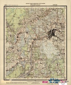
- Description:
- 1926
- Subject:
- Geographic Subject: Velizh, Topical Subject: Soviet Union, and Topical Subject: Maps
- Publisher:
- Военно-топографическое управление
- Language:
- Russian
- Identifier:
- VAC9619-001222
- Genre:
- Topographic Maps and Military Maps
- Geographic Location:
- Coordinates: 55.5, 31, 55.6667, 31.25
- Related URL:
- Catalog URL: http://iucat.iu.edu/catalog/5020131 and Download GeoTIFF: https://drive.google.com/open?id=1J6hNpeoiw5pxXOf4w-lPlsgnoJdwxh2N
- Abstract:
- Modern area represented: Velizh, Smolensk oblast, Russia
- Call Number:
- GM G7000 S50 .S68 N-36-15-A
- Caption:
- Секретно
- City:
- Велиж (Velizh)
- Copyright Holder:
- No Copyright - United States
- Country:
- СССР (USSR)
- State/Province:
- Западная область (Western oblast) and РСФСР (RSFSR)
- Physical Description:
- Scale: 1:50,000
- Persistent URL:
- http://purl.dlib.indiana.edu/iudl/images/VAC9619/VAC9619-001222
- Provenance:
- M. I. Map Library, G000-30, GS, RA
-
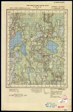
- Description:
- 1937
- Subject:
- Topical Subject: Maps, Topical Subject: Soviet Union, and Geographic Subject: Zenino
- Publisher:
- Главное управление государственной съемки и картографии НКВД СССР
- Language:
- Russian
- Identifier:
- VAC9619-003012
- Genre:
- Military Maps and Topographic Maps
- Geographic Location:
- Coordinates: 59.333, 31.5, 59.5, 31.75
- Related URL:
- Download GeoTIFF: https://drive.google.com/file/d/1jQcCmrOddHVgk6gEwdGWG0-JCsxASGdI/view?usp=sharing and Catalog URL: http://iucat.iu.edu/catalog/5020131
- Abstract:
- Modern area represented: Zenino, Leningrad oblast, Russia
- Call Number:
- G7000 s50 .S68 sheet O-36-16-C
- Caption:
- Для служебного пользования
- City:
- Зенино (Zenino)
- Copyright Holder:
- No Copyright - United States
- Country:
- СССР (USSR)
- State/Province:
- Киришский район (Kirishsky district), РСФСР (RSFSR), Чудовский район (Chudovsky district), Ленинградская область (Leningrad oblast), and Тосненский район (To...
- Physical Description:
- Scale: 1:50,000
- Persistent URL:
- http://purl.dlib.indiana.edu/iudl/images/VAC9619/VAC9619-003012
- Provenance:
- M. I. Map Library, Atlasblatt
-
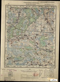
- Description:
- 1936
- Subject:
- Topical Subject: Maps, Geographic Subject: Kryakusha, and Topical Subject: Soviet Union
- Publisher:
- Управление военных топографов РККА
- Language:
- Russian
- Identifier:
- VAC9619-002807
- Genre:
- Military Maps and Topographic Maps
- Geographic Location:
- Coordinates: 57.667, 28.5, 57.833, 28.75
- Related URL:
- Catalog URL: http://iucat.iu.edu/catalog/5020131 and Download GeoTIFF: https://drive.google.com/file/d/1DXiqfT3K8Ch29aROKepDdUq69Q2mvw7F/view?usp=sharing
- Abstract:
- Modern area represented: Крякуша (Kryakusha), Псковская область (Pskovskaya oblast), Russia
- Call Number:
- GM G7000 s50 .S68 sheet O-35-82-C
- Caption:
- Не подлежит оглашению and Captured map
- City:
- Крякуша (Kryakusha)
- Copyright Holder:
- No Copyright - United States
- Country:
- СССР (USSR)
- State/Province:
- РСФСР (RSFSR) and Ленинградская область (Leningrad oblast)
- Physical Description:
- Scale: 1:50,000
- Persistent URL:
- http://purl.dlib.indiana.edu/iudl/images/VAC9619/VAC9619-002807
- Provenance:
- Army Map Service Library, Library of Congress G & M Division
-
- Subject:
- Geographic Subject: Naro-Fominsk, Topical Subject: Soviet Union, and Topical Subject: Maps
- Publisher:
- Генеральный штаб Красной Армии
- Language:
- Russian
- Identifier:
- VAC9619-003076
- Genre:
- Topographic Maps and Military Maps
- Geographic Location:
- Coordinates: 55.333, 36.5, 55.667, 37
- Related URL:
- Download GeoTIFF: https://drive.google.com/file/d/1-AjlHfuf7chz099YGfAVBKwIGFHbA7cN/view?usp=sharing and Catalog URL: https://iucat.iu.edu/catalog/5020129
- Abstract:
- Modern area represented: Naro-Fominsk, Moscow oblast, Russia
- Call Number:
- G7000 s100 .S7 sheet N-37-14
- Caption:
- Для служебного пользования
- City:
- Наро-Фоминск (Naro-Fominsk)
- Copyright Holder:
- No Copyright - United States
- Country:
- СССР (USSR)
- State/Province:
- РСФСР (RSFSR) and Московская область (Moscow oblast)
- Physical Description:
- Scale: 1:100,000
- Persistent URL:
- http://purl.dlib.indiana.edu/iudl/images/VAC9619/VAC9619-003076
- Provenance:
- DMA Topographic Center, Army Map Service Library, OMAHA, Library of Congress Geography & Map Division, Geographic Names Branch
-
- Description:
- 1937
- Subject:
- Topical Subject: Soviet Union, Topical Subject: Maps, and Geographic Subject: Mayevo
- Publisher:
- Генеральный штаб РККА
- Language:
- Russian
- Identifier:
- VAC9619-003213
- Genre:
- Topographic Maps and Military Maps
- Geographic Location:
- Coordinates: 56.333, 29.5, 56.667, 30
- Related URL:
- Catalog URL: https://iucat.iu.edu/catalog/5020129 and Download GeoTIFF: https://drive.google.com/file/d/1zj5gMT2nZnbyRd5xi88MhCYOPVGv6zI-/view?usp=sharing
- Abstract:
- Modern area represented: Маево (Mayevo), Pskovskaya oblast, Russia
- Call Number:
- G7000 s100 .S7 sheet O-35-132
- Caption:
- Для служебного пользования
- City:
- Маево (Mayevo)
- Copyright Holder:
- No Copyright - United States
- Country:
- СССР (USSR)
- State/Province:
- РСФСР (RSFSR) and Калининская область (Kalinin oblast)
- Physical Description:
- Scale: 1:100,000
- Persistent URL:
- http://purl.dlib.indiana.edu/iudl/images/VAC9619/VAC9619-003213
- Provenance:
- DMA Topographic Center, Army Map Service Library, OMAHA, Reichsamt für Landesaufnahme, Kartensammlung
-
- Description:
- 1937
- Subject:
- Topical Subject: Soviet Union, Geographic Subject: Plyussa, and Topical Subject: Maps
- Publisher:
- Генеральный штаб РККА
- Language:
- Russian
- Identifier:
- VAC9619-000030
- Genre:
- Topographic Maps and Military Maps
- Geographic Location:
- Coordinates: 58.333, 29.25, 58.5, 29.5
- Related URL:
- Catalog URL: http://iucat.iu.edu/catalog/5020131 and Download GeoTIFF: https://drive.google.com/open?id=1OP_m9uayq_QWeJiS3O7i54yLcEGmsrUr
- Abstract:
- Modern area represented: Plyussa, Pskov oblast, Russia
- Call Number:
- G7000 s50 .S68 sheet O-35-59-D
- Caption:
- Не подлежит оглашению,Captured map
- City:
- Плюсса (Plyussa)
- Copyright Holder:
- No Copyright - United States
- Country:
- СССР (USSR)
- State/Province:
- РСФСР (RSFSR) and Ленинградская область (Leningrad oblast)
- Physical Description:
- Scale: 1:50,000
- Persistent URL:
- http://purl.dlib.indiana.edu/iudl/images/VAC9619/VAC9619-000030
- Provenance:
- Army Map Service Library, OMAHA, Library of Congress Geography & Map Division
-
- Description:
- 1941
- Subject:
- Topical Subject: Maps, Topical Subject: Soviet Union, and Geographic Subject: Chaplygin
- Publisher:
- Генеральный штаб Красной Армии
- Language:
- Russian
- Identifier:
- VAC9619-003064
- Genre:
- Military Maps and Topographic Maps
- Geographic Location:
- Coordinates: 53, 39.5, 53.333, 40
- Related URL:
- Catalog URL: https://iucat.iu.edu/catalog/5020129 and Download GeoTIFF: https://drive.google.com/file/d/1O91xuuaERd2HtVZWSxZEz_WX8uwgxZnF/view?usp=sharing
- Abstract:
- Modern area represented: Чаплыгин (Chaplygin), Lipetskaya oblast, Russia
- Call Number:
- G7000 s100 .S7 sheet N-37-104
- City:
- Раненбург (Ranenburg)
- Copyright Holder:
- No Copyright - United States
- Country:
- СССР (USSR)
- State/Province:
- РСФСР (RSFSR) and Рязанская область (Ryazan oblast)
- Physical Description:
- Scale: 1:100,000
- Persistent URL:
- http://purl.dlib.indiana.edu/iudl/images/VAC9619/VAC9619-003064
- Provenance:
- Army Map Service Library, Library of Congress G & M Division
-
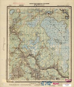
- Description:
- 1927
- Subject:
- Geographic Subject: Ordynka, Topical Subject: Soviet Union, and Topical Subject: Maps
- Publisher:
- Военно-топографическое управление
- Language:
- Russian
- Identifier:
- VAC9619-001196
- Genre:
- Military Maps and Topographic Maps
- Geographic Location:
- Coordinates: 55.8333, 32, 56, 32.25
- Related URL:
- Download GeoTIFF: https://drive.google.com/open?id=1AbPgfYMrmpfstQexUb-V9LxNOUkAC9_X and Catalog URL: http://iucat.iu.edu/catalog/5020131
- Abstract:
- Modern area represented: Ordynka, Tver oblast, Russia
- Call Number:
- GM G7000 S50 .S68 N-36-5-A
- Caption:
- Секретно
- City:
- Ордынка (Ordynka)
- Copyright Holder:
- No Copyright - United States
- Country:
- СССР (USSR)
- State/Province:
- РСФСР (RSFSR) and Западная область (Western oblast)
- Physical Description:
- Scale: 1:50,000
- Persistent URL:
- http://purl.dlib.indiana.edu/iudl/images/VAC9619/VAC9619-001196
- Provenance:
- M. I. Map Library, G000-30, GS, RA, Atlasblatt
-
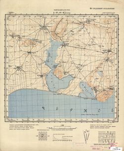
- Subject:
- Topical Subject: Maps, Topical Subject: Soviet Union, and Geographic Subject: Marivka
- Publisher:
- Генеральный штаб РККА
- Language:
- Russian
- Identifier:
- VAC9619-000135
- Genre:
- Military Maps and Topographic Maps
- Geographic Location:
- Coordinates: 45, 36, 45.1667, 36.25
- Related URL:
- Catalog URL: http://iucat.iu.edu/catalog/5020131 and Download GeoTIFF: https://drive.google.com/open?id=1PT8SdyXHcahebOwNRwqtocvV-yNJmkwb
- Abstract:
- Modern area represented: Marivka, Republic of Crimea, Ukraine
- Call Number:
- G7000 s50 .S68 sheet L-37-97-C
- Caption:
- Не подлежит оглашению
- City:
- Марьевка (Maryevka)
- Copyright Holder:
- No Copyright - United States
- Country:
- СССР (USSR)
- State/Province:
- РСФСР (RSFSR) and Крымская АССР (Crimean Autonomous Soviet Socialist Republic)
- Physical Description:
- Scale: 1:50,000
- Persistent URL:
- http://purl.dlib.indiana.edu/iudl/images/VAC9619/VAC9619-000135
- Provenance:
- CIA Map Branch -- Received, G000-30
-
- Description:
- 1938
- Subject:
- Topical Subject: Maps, Geographic Subject: Bol'shiye Ugorody, and Topical Subject: Soviet Union
- Publisher:
- Генеральный штаб РККА
- Language:
- Russian
- Identifier:
- VAC9619-003361
- Genre:
- Military Maps and Topographic Maps
- Geographic Location:
- Coordinates: 58.333, 30.25, 58.5, 30.5
- Related URL:
- Catalog URL: http://iucat.iu.edu/catalog/5020131 and Download GeoTIFF: https://drive.google.com/file/d/1EZ1YTAeis-FusH7NbN3tGkJQdrFqgnVf/view?usp=sharing
- Abstract:
- Modern area represented: Большие Угороды (Bol'shiye Ugorody), Novgorodskaya oblast, Russia
- Call Number:
- G7000 s50 .S68 sheet O-36-49-D
- Caption:
- Не подлежит оглашению
- City:
- Большие Угороды (Bol'shiye Ugorody)
- Copyright Holder:
- No Copyright - United States
- Country:
- СССР (USSR)
- State/Province:
- РСФСР (RSFSR) and Ленинградская область (Leningrad oblast)
- Physical Description:
- Scale: 1:50,000
- Persistent URL:
- http://purl.dlib.indiana.edu/iudl/images/VAC9619/VAC9619-003361
- Provenance:
- Army Map Service Library, OMAHA
-
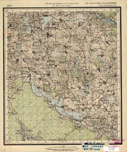
- Description:
- 1926
- Subject:
- Geographic Subject: Pukhnovo, Topical Subject: Soviet Union, and Topical Subject: Maps
- Publisher:
- Управление военных топографов РККА
- Language:
- Russian
- Identifier:
- VAC9619-001188
- Genre:
- Military Maps and Topographic Maps
- Geographic Location:
- Coordinates: 55.8333, 31, 56, 31.25
- Related URL:
- Download GeoTIFF: https://drive.google.com/open?id=1NABJEth3rjI2iCLt9qSEOmI3AvkryE_A and Catalog URL: http://iucat.iu.edu/catalog/5020131
- Abstract:
- Modern area represented: Pukhnovo, Pskov oblast, Russia
- Call Number:
- GM G7000 S50 .S68 N-36-3-A
- Caption:
- Не подлежит оглашению
- City:
- Пухново (Pukhnovo)
- Copyright Holder:
- No Copyright - United States
- Country:
- СССР (USSR)
- State/Province:
- Западная область (Western oblast) and РСФСР (RSFSR)
- Physical Description:
- Scale: 1:50,000
- Persistent URL:
- http://purl.dlib.indiana.edu/iudl/images/VAC9619/VAC9619-001188
- Provenance:
- M. I. Map Library
-
- Description:
- 1926
- Subject:
- Topical Subject: Maps and Topical Subject: Soviet Union
- Publisher:
- Военно-топографическое управление
- Language:
- Russian
- Identifier:
- VAC9619-001269
- Genre:
- Topographic Maps and Military Maps
- Geographic Location:
- Coordinates: 55, 32.25, 55.1667, 32.5
- Related URL:
- Catalog URL: http://iucat.iu.edu/catalog/5020131 and Download GeoTIFF: https://drive.google.com/open?id=1t4OhII8iHo20yjaTax69QMCIzL9m4cu_
- Abstract:
- Modern area represented: Smolensk oblast, Russia
- Call Number:
- GM G7000 S50 .S68 N-36-29-Г
- Caption:
- Секретно
- City:
- Барсуки (Barsuki)
- Copyright Holder:
- No Copyright - United States
- Country:
- СССР (USSR)
- State/Province:
- РСФСР (RSFSR) and Западная область (Western oblast)
- Physical Description:
- Scale: 1:50,000
- Persistent URL:
- http://purl.dlib.indiana.edu/iudl/images/VAC9619/VAC9619-001269
- Provenance:
- DMA Topographic Center, Army Map Service Library, OMAHA, Library of Congress Geography & Map Division
-
- Description:
- 1937
- Subject:
- Geographic Subject: Bezhanitsy, Topical Subject: Soviet Union, and Topical Subject: Maps
- Publisher:
- Генеральный штаб РККА
- Language:
- Russian
- Identifier:
- VAC9619-003206
- Genre:
- Military Maps and Topographic Maps
- Geographic Location:
- Coordinates: 56.667, 29.5, 57, 30
- Related URL:
- Catalog URL: https://iucat.iu.edu/catalog/5020129 and Download GeoTIFF: https://drive.google.com/file/d/1KZ2suBAjRLkeNDlzWBKJckSPiz9pTs6B/view?usp=sharing
- Abstract:
- Modern area represented: Бежаницы (Bezhanitsy), Pskovskaya oblast, Russia
- Call Number:
- G7000 s100 .S7 sheet O-35-120
- Caption:
- Не подлежит оглашению and Captured map
- City:
- Бежаницы (Bezhanitsy)
- Copyright Holder:
- No Copyright - United States
- Country:
- СССР (USSR)
- State/Province:
- Калининская область (Kalinin oblast) and РСФСР (RSFSR)
- Physical Description:
- Scale: 1:100,000
- Persistent URL:
- http://purl.dlib.indiana.edu/iudl/images/VAC9619/VAC9619-003206
- Provenance:
- DMA Topographic Center, Army Map Service Library, OMAHA
-
- Description:
- 1935
- Subject:
- Topical Subject: Maps, Topical Subject: Soviet Union, and Geographic Subject: Yevzhozero
- Publisher:
- Itä-Karjalan kartasto
- Language:
- Russian
- Identifier:
- VAC9619-002473
- Genre:
- Military Maps and Topographic Maps
- Geographic Location:
- Coordinates: 63.667, 32.5, 64, 33
- Related URL:
- Download GeoTIFF: https://drive.google.com/file/d/1HE4XTpQ9Cmd_SgHBh0J3YdxC4mBmhxBx/view?usp=sharing and Catalog URL: https://iucat.iu.edu/catalog/5020129
- Abstract:
- Modern area represented: Yevzhozero, Republic of Karelia, Russia
- Call Number:
- G7000 s100 .S7 sheet P-36-6
- Caption:
- Captured map
- City:
- Евжозеро (Yevzhozero)
- Copyright Holder:
- No Copyright - United States
- Country:
- СССР (USSR)
- State/Province:
- РСФСР (RSFSR) and Карельская АССР (Karelian Autonomous Soviet Socialist Republic)
- Physical Description:
- Scale: 1:100,000
- Persistent URL:
- http://purl.dlib.indiana.edu/iudl/images/VAC9619/VAC9619-002473
- Provenance:
- DMA Topographic Center, Army Map Service Library, OMAHA
-
- Description:
- 1936
- Subject:
- Topical Subject: Soviet Union, Geographic Subject: Motokhovo, and Topical Subject: Maps
- Publisher:
- Главное управление государственной съемки и картографии НКВД СССР
- Language:
- Russian
- Identifier:
- VAC9619-003055
- Genre:
- Topographic Maps and Military Maps
- Geographic Location:
- Coordinates: 59.5, 32.25, 59.667, 32.5
- Related URL:
- Download GeoTIFF: https://drive.google.com/file/d/1OSXXWrNmak2flUfvvQS3WZsIMOH68RHQ/view?usp=sharing and Catalog URL: http://iucat.iu.edu/catalog/5020131
- Abstract:
- Modern area represented: Motokhovo, Leningrad oblast, Russia
- Call Number:
- GM G7000 s50 .S68 sheet O-36-17-B
- Caption:
- Для служебного пользования,Captured map
- City:
- Мотохово (Motokhovo)
- Copyright Holder:
- No Copyright - United States
- Country:
- СССР (USSR)
- State/Province:
- Киришский район (Kirishsky district), Ленинградская область (Leningrad oblast), Волховский район (Volkhov district), and РСФСР (RSFSR)
- Physical Description:
- Scale: 1:50,000
- Persistent URL:
- http://purl.dlib.indiana.edu/iudl/images/VAC9619/VAC9619-003055
- Provenance:
- Army Map Service Library, OMAHA, Library of Congress Geography & Map Division
-

- Description:
- 1941
- Subject:
- Topical Subject: Soviet Union, Topical Subject: Maps, and Geographic Subject: Kletsko-Pochtovskiy
- Publisher:
- Генеральный штаб Красной Армии
- Language:
- Russian
- Identifier:
- VAC9619-003417
- Genre:
- Topographic Maps and Military Maps
- Geographic Location:
- Coordinates: 49.333, 43, 49.667, 43.5
- Related URL:
- Download GeoTIFF: https://drive.google.com/file/d/1c6rqPfzZXBYfj--aE1lsJHK0reAcVVfc/view?usp=sharing and Catalog URL: https://iucat.iu.edu/catalog/5020129
- Abstract:
- Modern area represented: Kletsko-Pochtovskiy, Volgograd oblast, Russia
- Call Number:
- G7000 s100 .S7 sheet M-38-87
- Caption:
- Для служебного пользования
- City:
- Клетско-Почтовский (Kletsko-Pochtovskiy)
- Copyright Holder:
- No Copyright - United States
- Country:
- СССР (USSR)
- State/Province:
- РСФСР (RSFSR) and Сталинградская область (Stalingrad oblast)
- Physical Description:
- Scale: 1:100,000
- Persistent URL:
- http://purl.dlib.indiana.edu/iudl/images/VAC9619/VAC9619-003417
- Provenance:
- Army Map Service Library, Library of Congress G & M Division, Geographic Names Branch
-
- Description:
- 1932
- Subject:
- Topical Subject: Soviet Union, Geographic Subject: Lyubyn, and Topical Subject: Maps
- Publisher:
- Управление военных топографов
- Language:
- Russian
- Identifier:
- VAC9619-002906
- Genre:
- Military Maps and Topographic Maps
- Geographic Location:
- Coordinates: 58, 30.5, 58.167, 30.75
- Related URL:
- Download GeoTIFF: https://drive.google.com/file/d/128ujqRn1-NJT7mXO6X6FxWTV2RPADtWI/view?usp=sharing and Catalog URL: http://iucat.iu.edu/catalog/5020131
- Abstract:
- Modern area represented: Lyubyn, Leningrad oblast, Russia
- Call Number:
- GM G7000 s50 .S68 sheet O-36-62-С
- Caption:
- Не подлежит оглашению,Captured map
- City:
- Любынь (Lyubyn)
- Copyright Holder:
- No Copyright - United States
- Country:
- СССР (USSR)
- State/Province:
- Ленинградская область (Leningrad oblast) and РСФСР (RSFSR)
- Physical Description:
- Scale: 1:50,000
- Persistent URL:
- http://purl.dlib.indiana.edu/iudl/images/VAC9619/VAC9619-002906
- Provenance:
- DMA Topographic Center, Army Map Service Library, OMAHA, Library of Congress Geography & Map Division
-
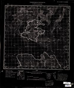
- Description:
- 1936
- Subject:
- Topical Subject: Maps, Geographic Subject: Mount Konskaya Golova, and Topical Subject: Soviet Union
- Publisher:
- Управление военных топографов РККА
- Language:
- Russian
- Identifier:
- VAC9619-002584
- Genre:
- Military Maps and Topographic Maps
- Geographic Location:
- Coordinates: 47.667, 138.5, 48, 139
- Related URL:
- Download GeoTIFF: https://drive.google.com/file/d/1hh1M1a9FQWxe9zRW0GYu74bta20N3WMJ/view?usp=sharing and Catalog URL: https://iucat.iu.edu/catalog/5020129
- Abstract:
- Modern area represented: Mount Konskaya Golova, Russia
- Call Number:
- G7000 s100 .S7 sheet L-54-2
- Caption:
- Не подлежит оглашению
- City:
- Гора Конская Голова (Mount Konskaya Golova)
- Copyright Holder:
- No Copyright - United States
- Country:
- СССР (USSR)
- State/Province:
- РСФСР (RSFSR) and Дальневосточный край (Far Eastern kray)
- Physical Description:
- Scale: 1:100,000
- Persistent URL:
- http://purl.dlib.indiana.edu/iudl/images/VAC9619/VAC9619-002584
- Provenance:
- Army Map Service Library
