
Search Constraints
You searched for:
Provenance
DMA Topographic Center, Army Map Service Library, OMAHA, Library of Congress Geography & Map Division
Remove constraint Provenance: DMA Topographic Center, Army Map Service Library, OMAHA, Library of Congress Geography & Map Division
Publisher
Главное управление геодезии и картографии при СНК СССР
Remove constraint Publisher: Главное управление геодезии и картографии при СНК СССР
State
deposited
Remove constraint State: deposited
Search Results
-

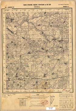
- Description:
- 1939
- Subject:
- Geographic Subject: Felistovo, Topical Subject: Maps, and Topical Subject: Soviet Union
- Publisher:
- Главное управление геодезии и картографии при СНК СССР
- Language:
- Russian
- Date Created:
- 1941
- Identifier:
- VAC9619-002894
- Genre:
- Military Maps and Topographic Maps
- Geographic Location:
- Coordinates: 56.667, 33.25, 56.833, 33.5
- Related URL:
- DataCORE Dataset Download: https://datacore.iu.edu/concern/data_sets/7p88ch47f
- Abstract:
- Modern area represented: Фелистово (Felistovo), Tverskaya oblast, Russia
- Call Number:
- GM G7000 s50 .S68 sheet O-36-115-D
- Caption:
- Для служебного пользования
- City:
- Фелистово (Felistovo)
- Copyright Holder:
- No Copyright - United States
- Country:
- СССР (USSR)
- State/Province:
- Кировский район (Kirov district) and Калининская область (Kalinin oblast)
- Physical Description:
- Scale: 1:50,000
- Persistent URL:
- http://purl.dlib.indiana.edu/iudl/images/VAC9619/VAC9619-002894
- Provenance:
- DMA Topographic Center, Army Map Service Library, OMAHA, Library of Congress Geography & Map Division
-
- Description:
- 1939
- Subject:
- Topical Subject: Maps, Topical Subject: Soviet Union, and Geographic Subject: Berezug
- Publisher:
- Главное управление геодезии и картографии при СНК СССР
- Language:
- Russian
- Date Created:
- 1941
- Identifier:
- VAC9619-002895
- Genre:
- Topographic Maps and Military Maps
- Geographic Location:
- Coordinates: 56.833, 33.5, 57, 33.75
- Related URL:
- DataCORE Dataset Download: https://datacore.iu.edu/concern/data_sets/1j92g833z
- Abstract:
- Modern area represented: Березуг (Berezug), Tverskaya oblast, Russia
- Call Number:
- GM G7000 s50 .S68 sheet O-36-116-A
- Caption:
- Для служебного пользования
- City:
- Березуг (Berezug)
- Copyright Holder:
- No Copyright - United States
- Country:
- СССР (USSR)
- State/Province:
- Кировский район (Kirov district) and Калининская область (Kalinin oblast)
- Physical Description:
- Scale: 1:50,000
- Persistent URL:
- http://purl.dlib.indiana.edu/iudl/images/VAC9619/VAC9619-002895
- Provenance:
- DMA Topographic Center, Army Map Service Library, OMAHA, Library of Congress Geography & Map Division
-
- Description:
- 1939
- Subject:
- Geographic Subject: Dubrovki, Topical Subject: Maps, and Topical Subject: Soviet Union
- Publisher:
- Главное управление геодезии и картографии при СНК СССР
- Language:
- Russian
- Date Created:
- 1941
- Identifier:
- VAC9619-002893
- Genre:
- Military Maps and Topographic Maps
- Geographic Location:
- Coordinates: 56.667, 33, 56.833, 33.25
- Related URL:
- DataCORE Dataset Download: https://datacore.iu.edu/concern/data_sets/cr56n1737
- Abstract:
- Modern area represented: Дубровки (Dubrovki), Tverskaya oblast, Russia
- Call Number:
- GM G7000 s50 .S68 sheet O-36-115-C
- Caption:
- Для служебного пользования
- City:
- Дубровки (Dubrovki)
- Copyright Holder:
- No Copyright - United States
- Country:
- СССР (USSR)
- State/Province:
- Пеновский район (Penovsky district), Калининская область (Kalinin oblast), and Кировский район (Kirov district)
- Physical Description:
- Scale: 1:50,000
- Persistent URL:
- http://purl.dlib.indiana.edu/iudl/images/VAC9619/VAC9619-002893
- Provenance:
- DMA Topographic Center, Army Map Service Library, OMAHA, Library of Congress Geography & Map Division
-
- Description:
- 1939
- Subject:
- Topical Subject: Soviet Union, Geographic Subject: Selekhovo, and Topical Subject: Maps
- Publisher:
- Главное управление геодезии и картографии при СНК СССР
- Language:
- Russian
- Date Created:
- 1941
- Identifier:
- VAC9619-002892
- Genre:
- Military Maps and Topographic Maps
- Geographic Location:
- Coordinates: 56.667, 32.75, 56.833, 33
- Related URL:
- DataCORE Dataset Download: https://datacore.iu.edu/concern/data_sets/zg64tm65s
- Abstract:
- Modern area represented: Селехово (Selekhovo), Tverskaya oblast, Russia
- Call Number:
- GM G7000 s50 .S68 sheet O-36-114-D
- Caption:
- Для служебного пользования
- City:
- Селехово (Selekhovo)
- Copyright Holder:
- No Copyright - United States
- Country:
- СССР (USSR)
- State/Province:
- Пеновский район (Penovsky district), Калининская область (Kalinin oblast), and Леновский район (Lenovsky district)
- Physical Description:
- Scale: 1:50,000
- Persistent URL:
- http://purl.dlib.indiana.edu/iudl/images/VAC9619/VAC9619-002892
- Provenance:
- DMA Topographic Center, Army Map Service Library, OMAHA, Library of Congress Geography & Map Division
-
- Description:
- 1939
- Subject:
- Topical Subject: Soviet Union, Topical Subject: Maps, and Geographic Subject: Shuvayevo
- Publisher:
- Главное управление геодезии и картографии при СНК СССР
- Language:
- Russian
- Date Created:
- 1941
- Identifier:
- VAC9619-002891
- Genre:
- Topographic Maps and Military Maps
- Geographic Location:
- Coordinates: 56.833, 33, 57, 33.25
- Related URL:
- DataCORE Dataset Download: https://datacore.iu.edu/concern/data_sets/gf06g3520
- Abstract:
- Modern area represented: Шуваево (Shuvayevo), Tverskaya oblast, Russia
- Call Number:
- GM G7000 s50 .S68 sheet O-36-115-A
- Caption:
- Для служебного пользования
- City:
- Шуваево (Shuvayevo)
- Copyright Holder:
- No Copyright - United States
- Country:
- СССР (USSR)
- State/Province:
- Калининская область (Kalinin oblast) and РСФСР (RSFSR)
- Physical Description:
- Scale: 1:50,000
- Persistent URL:
- http://purl.dlib.indiana.edu/iudl/images/VAC9619/VAC9619-002891
- Provenance:
- DMA Topographic Center, Army Map Service Library, OMAHA, Library of Congress Geography & Map Division
-
- Subject:
- Topical Subject: Soviet Union, Geographic Subject: Toropatsa, and Topical Subject: Maps
- Publisher:
- Главное управление геодезии и картографии при СНК СССР
- Language:
- Russian
- Date Created:
- 1941
- Identifier:
- VAC9619-002886
- Genre:
- Military Maps and Topographic Maps
- Geographic Location:
- Coordinates: 56.667, 31.75, 56.833, 32
- Related URL:
- DataCORE Dataset Download: https://datacore.iu.edu/concern/data_sets/9p290b09p
- Abstract:
- Modern area represented: Торопаца (Toropatsa), Tverskaya oblast, Russia
- Call Number:
- GM G7000 s50 .S68 sheet O-36-112-D
- City:
- Торопацы (Toropatsy)
- Copyright Holder:
- No Copyright - United States
- Country:
- СССР (USSR)
- State/Province:
- Сережинский район (Serezhinsky district), Ленинский район (Leninsky district), Калининская область (Kalinin oblast), and Торопецкий район (Toropetsky district)
- Physical Description:
- Scale: 1:50,000
- Persistent URL:
- http://purl.dlib.indiana.edu/iudl/images/VAC9619/VAC9619-002886
- Provenance:
- DMA Topographic Center, Army Map Service Library, OMAHA, Library of Congress Geography & Map Division
-
- Subject:
- Topical Subject: Soviet Union, Geographic Subject: Bologovo, and Topical Subject: Maps
- Publisher:
- Главное управление геодезии и картографии при СНК СССР
- Language:
- Russian
- Date Created:
- 1941
- Identifier:
- VAC9619-002885
- Genre:
- Topographic Maps and Military Maps
- Geographic Location:
- Coordinates: 56.833, 31.5, 57, 31.75
- Related URL:
- DataCORE Dataset Download: https://datacore.iu.edu/concern/data_sets/sf2685977
- Abstract:
- Modern area represented: Бологово (Bologovo), Tverskaya oblast, Russia
- Call Number:
- GM G7000 s50 .S68 sheet O-36-112-A
- Caption:
- Для служебного пользования
- City:
- Сережино (Serezhino)
- Copyright Holder:
- No Copyright - United States
- Country:
- СССР (USSR)
- State/Province:
- Сережинский район (Serezhinsky district) and Калининская область (Kalinin oblast)
- Physical Description:
- Scale: 1:50,000
- Persistent URL:
- http://purl.dlib.indiana.edu/iudl/images/VAC9619/VAC9619-002885
- Provenance:
- DMA Topographic Center, Army Map Service Library, OMAHA, Library of Congress Geography & Map Division
-
- Description:
- 1938
- Subject:
- Topical Subject: Soviet Union, Topical Subject: Maps, and Geographic Subject: Bol’shoye Ploskoye
- Publisher:
- Главное управление геодезии и картографии при СНК СССР
- Language:
- Russian
- Date Created:
- 1941
- Identifier:
- VAC9619-002850
- Genre:
- Topographic Maps and Military Maps
- Geographic Location:
- Coordinates: 57.167, 35.25, 57.333, 35.5
- Related URL:
- DataCORE Dataset Download: https://datacore.iu.edu/concern/data_sets/w6634440t
- Abstract:
- Modern area represented: Большое Плоское (Bol’shoye Ploskoye), Тверская область (Tverskaya oblast), Russia
- Call Number:
- GM G7000 s50 .S68 sheet O-36-107-B
- Caption:
- Captured map
- City:
- Большое Плоское (Bol’shoye Ploskoye)
- Copyright Holder:
- No Copyright - United States
- Country:
- СССР (USSR)
- State/Province:
- Новоторжский район (Novotorzhsky district), Лихославльский район (Likhoslavlsky district), and Калининская область (Kalinin oblast)
- Physical Description:
- Scale: 1:50,000
- Persistent URL:
- http://purl.dlib.indiana.edu/iudl/images/VAC9619/VAC9619-002850
- Provenance:
- DMA Topographic Center, Army Map Service Library, OMAHA, Library of Congress Geography & Map Division
-
- Description:
- 1938
- Subject:
- Geographic Subject: Torzhok, Topical Subject: Soviet Union, and Topical Subject: Maps
- Publisher:
- Главное управление геодезии и картографии при СНК СССР
- Language:
- Russian
- Identifier:
- VAC9619-002849
- Genre:
- Military Maps and Topographic Maps
- Geographic Location:
- Coordinates: 57, 34.75, 57.167, 35
- Related URL:
- DataCORE Dataset Download: https://datacore.iu.edu/concern/data_sets/1544bp89m
- Abstract:
- Modern area represented: Торжок (Torzhok), Тверская область (Tverskaya oblast), Russia
- Call Number:
- GM G7000 s50 .S68 sheet O-36-106-D
- Caption:
- Для служебного пользования
- City:
- Торжок (Torzhok)
- Copyright Holder:
- No Copyright - United States
- Country:
- СССР (USSR)
- State/Province:
- Калининская область (Kalinin oblast) and Новоторжский район (Novotorzhsky district)
- Physical Description:
- Scale: 1:50,000
- Persistent URL:
- http://purl.dlib.indiana.edu/iudl/images/VAC9619/VAC9619-002849
- Provenance:
- DMA Topographic Center, Army Map Service Library, OMAHA, Library of Congress Geography & Map Division
-
- Description:
- 1938
- Subject:
- Topical Subject: Soviet Union, Geographic Subject: Tysyatskoye, and Topical Subject: Maps
- Publisher:
- Главное управление геодезии и картографии при СНК СССР
- Language:
- Russian
- Date Created:
- 1941
- Identifier:
- VAC9619-002848
- Genre:
- Topographic Maps and Military Maps
- Geographic Location:
- Coordinates: 57, 34.25, 57.167, 34.5
- Related URL:
- DataCORE Dataset Download: https://datacore.iu.edu/concern/data_sets/bg257f87z
- Abstract:
- Modern area represented: Тысяцкое (Tysyatskoye), Тверская область (Tverskaya oblast), Russia
- Call Number:
- GM G7000 s50 .S68 sheet O-36-105-D
- Caption:
- Для служебного пользования and Captured map
- City:
- Тысяцкое (Tysyatskoye)
- Copyright Holder:
- No Copyright - United States
- Country:
- СССР (USSR)
- State/Province:
- Есеновичский район (Yesenovichsky district), Каменский район (Kamensky district), Новоторжский район (Novotorzhsky district), and Калининская область (Kalini...
- Physical Description:
- Scale: 1:50,000
- Persistent URL:
- http://purl.dlib.indiana.edu/iudl/images/VAC9619/VAC9619-002848
- Provenance:
- DMA Topographic Center, Army Map Service Library, OMAHA, Library of Congress Geography & Map Division
