
Search Constraints
You searched for:
Publisher
Indiana. Geological Survey
Remove constraint Publisher: Indiana. Geological Survey
Subject
Topical Subject: IGS Annual Reports
Remove constraint Subject: Topical Subject: IGS Annual Reports
« Previous |
1 - 10 of 32
|
Next »
Search Results
-
- Subject:
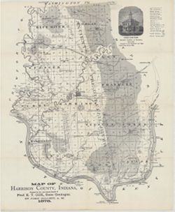
- Topical Subject: Mines and mineral resources, Topical Subject: IGS Annual Reports, Geographic Subject: Harrison County (Ind.), Topical Subject: Corydon Capit...
- Creator:
- Collett, John, 1828-1899
- Publisher:
- Indiana. Geological Survey
- Date Created:
- 1879
- Identifier:
- VAC3073-M-01554
- Genre:
- Geological maps
- Geographic Location:
- Coordinates: W0861951 W0855359 N0382520 N0375731
- Related URL:
- Catalog URL: https://iucat.iu.edu/catalog/18363798
- Abstract:
- Prepared for the 10th annual report of Prof. E.T. Cox, State Geologist by John Collett, 1878. Relief shown by hachures. Shows cities and towns, railroads, sp...
- Call Number:
- G4093.H4C5 1878 .C6
- Caption:
- Imprint: [Indianapolis] : [Geological Survey of Indiana], [1879] and Imprint: [Indianapolis] : [Indianapolis Journal Company, State printers], [1879]
- Physical Description:
- Dimensions: on sheet 44 x 36 cm and Scale: Approximately 1:130,000
- Alternate Identifier:
- Alternate ID: 390723IP and Title Control Number: a18363798
- Persistent URL:
- https://purl.dlib.indiana.edu/iudl/images/VAC3073/VAC3073-M-01554
- Provenance:
- 8th, 9th, and 10th Annual Reports (1876, 1877, 1878) / Indiana. Geological Survey.
-
- Subject:
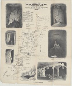
- Topical Subject: Caves, Topical Subject: IGS Annual Reports, Topical Subject: Speleothems, and Geographic Subject: Wyandotte Cave (Ind.)
- Creator:
- Collett, John, 1828-1899
- Publisher:
- Indiana. Geological Survey
- Date Created:
- 1879
- Identifier:
- VAC3073-M-01552
- Genre:
- Drawings, Pictorial works, Tables (Data), and Thematic maps
- Geographic Location:
- Coordinates: W0861746 W0861746 N0381341 N0381341
- Related URL:
- Catalog URL: https://iucat.iu.edu/catalog/18372653
- Abstract:
- Prepared for the 10th Annual Report of Prof. E. T. Cox, State Geologist, by John Collett, A. M. Relief shown by hachures. Includes sketches of some cave feat...
- Call Number:
- G4093.C7C23 1878 .C6
- Caption:
- Imprint: [Indianapolis] : [Indianapolis Journal Company, State printers], [1879] and Imprint: [Indianapolis] : [Geological Survey of Indiana], [1879]
- Physical Description:
- Dimensions: on sheet 54 x 46 cm and Scale: Approximately 1:11,000
- Alternate Identifier:
- Alternate ID: 390723IP and Title Control Number: a18372653
- Persistent URL:
- https://purl.dlib.indiana.edu/iudl/images/VAC3073/VAC3073-M-01552
- Provenance:
- 8th, 9th, and 10th Annual Reports (1876, 1877, 1878) / Indiana. Geological Survey.
-
- Subject:
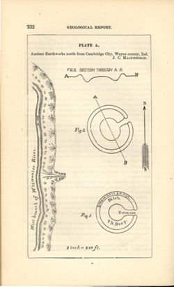
- Geographic Subject: Cambridge City (Ind.), Topical Subject: Henges, and Topical Subject: IGS Annual Reports
- Creator:
- Macpherson, J. C. (John C.)
- Publisher:
- Indiana. Geological Survey
- Date Created:
- 1879
- Identifier:
- VAC3073-M-01551
- Genre:
- Pictorial maps
- Geographic Location:
- Coordinates: W0851016 W0851004 N0395012 N0395001
- Related URL:
- Catalog URL: https://iucat.iu.edu/catalog/18387638
- Abstract:
- At head of title: Plate A. Relief shown by profile and spot heights. Includes pictorial map of west branch of Whitewater River and three figures showing heig...
- Call Number:
- G4094.C15E15 1878 .M33
- Caption:
- Imprint: [Indianapolis] : [Indianapolis Journal Company, State printers], [1879] and Imprint: [Indianapolis] : [Geological Survey of Indiana], [1879]
- Physical Description:
- Dimensions: on sheet 22 x 13 cm and Scale: Approximately 1:2,400. 1 inch = 200 ft.
- Alternate Identifier:
- Alternate ID: 390723IP and Title Control Number: a18387638
- Persistent URL:
- https://purl.dlib.indiana.edu/iudl/images/VAC3073/VAC3073-M-01551
- Provenance:
- 8th, 9th, and 10th Annual Reports (1876, 1877, 1878) / Indiana. Geological Survey.
-
- Subject:
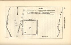
- Geographic Subject: New Garden (Ind. : Township), Topical Subject: Earthworks (Archaeology), and Topical Subject: IGS Annual Reports
- Creator:
- Macpherson, J. C. (John C.)
- Publisher:
- Indiana. Geological Survey
- Date Created:
- 1879
- Identifier:
- VAC3073-M-01550
- Genre:
- Pictorial maps
- Geographic Location:
- Coordinates: W0845400 W0845300 N0395800 N0395700
- Related URL:
- Catalog URL: https://iucat.iu.edu/catalog/18387636
- Abstract:
- At head of title: Plate C. Shows streams, pits, and earthwork [Indiana Adena Square?] with measurements. Detached from: Eighth, ninth, and tenth annual re...
- Call Number:
- G4094.N438 1978 .M33
- Caption:
- Imprint: [Indianapolis] : [Indianapolis Journal Company, State printers], [1879] and Imprint: [Indianapolis] : [Geological Survey of Indiana], [1879]
- Physical Description:
- Dimensions: on sheet 14 x 21 cm and Scale: Approximately 1:6,000. 1 inch = 500 ft.
- Alternate Identifier:
- Alternate ID: 390723IP and Title Control Number: a18387636
- Persistent URL:
- https://purl.dlib.indiana.edu/iudl/images/VAC3073/VAC3073-M-01550
- Provenance:
- 8th, 9th, and 10th Annual Reports (1876, 1877, 1878) / Indiana. Geological Survey.
-
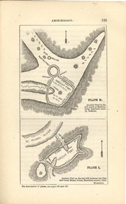
- Subject:
- Topical Subject: IGS Annual Reports, Topical Subject: Mounds, Topical Subject: Fortification, Prehistoric, Topical Subject: Indians of North America, Geograp...
- Creator:
- Morrison, Samuel (Civil engineer)
- Publisher:
- Indiana. Geological Survey
- Date Created:
- 1879
- Identifier:
- VAC3073-M-01548
- Genre:
- Pictorial maps
- Geographic Location:
- Coordinates: W0850758 W0844909 N0391829 N0385607
- Related URL:
- Catalog URL: https://iucat.iu.edu/catalog/18387663
- Abstract:
- At head of first title: Plate H , At head of second title: Plate I. Relief shown by hachures and spot heights. Shows prehistoric forts [Miami Fort and Oberti...
- Call Number:
- QE109 .A2
- Caption:
- Imprint: [Indianapolis] : [Geological Survey of Indiana], [1879] and Imprint: [Indianapolis] : [Indianapolis Journal Company, State printers], [1879]
- Physical Description:
- Dimensions: 22 x 14 cm and Scale: Scale not given.
- Alternate Identifier:
- Title Control Number: a18387663 and Alternate ID: 390723IP
- Persistent URL:
- https://purl.dlib.indiana.edu/iudl/images/VAC3073/VAC3073-M-01548
- Provenance:
- 8th, 9th, and 10th Annual Reports (1876, 1877, 1878) / Indiana. Geological Survey.
-
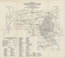
- Subject:
- Topical Subject: IGS Annual Reports, Topical Subject: Coal mines and mining, Geographic Subject: Crawford County (Ind.), Geographic Subject: Wyandotte Cave (...
- Creator:
- Collett, John, 1828-1899
- Publisher:
- Indiana. Geological Survey
- Date Created:
- 1879
- Identifier:
- VAC3073-M-01546
- Genre:
- Thematic maps
- Geographic Location:
- Coordinates: W0863746 W0861445 N0382324 N0380600
- Related URL:
- Catalog URL: https://iucat.iu.edu/catalog/18349479
- Abstract:
- Prepared for 10th annual report of Prof. E.T. Cox, State Geologist by John Collett, 1878. Relief shown by hachures. Shows cities and towns, railroads, cavern...
- Call Number:
- G4093.C7C5 1878 .C6
- Caption:
- Imprint: [Indianapolis] : [Geological Survey of Indiana], [1879] and Imprint: [Indianapolis] : [Indianapolis Journal Company, State printers], [1879]
- Physical Description:
- Scale: Approximately 1:125,000 and Dimensions: on sheet 39 x 44 cm
- Alternate Identifier:
- Title Control Number: a18349479 and Alternate ID: 390723IP
- Persistent URL:
- https://purl.dlib.indiana.edu/iudl/images/VAC3073/VAC3073-M-01546
- Provenance:
- 8th, 9th, and 10th Annual Reports (1876, 1877, 1878) / Indiana. Geological Survey.
-
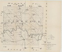
- Subject:
- Topical Subject: Mines and mineral resources, Topical Subject: Caves, Geographic Subject: Lawrence County (Ind.), Topical Subject: Geology, and Topical Subje...
- Creator:
- Collett, John, 1828-1899 and Cox, E. T. (Edward Travers), 1821-1907
- Publisher:
- Indiana. Geological Survey
- Date Created:
- 1874
- Identifier:
- VAC3073-M-01544
- Genre:
- Thematic maps
- Geographic Location:
- Coordinates: W0864107 W0861630 N0385938 N0384112
- Related URL:
- Catalog URL: https://iucat.iu.edu/catalog/18318621
- Abstract:
- Prepared for the 5th Annual Report of Prof. E.T. Cox. 1873. Geology by John Collett. Relief shown by hachures. Shows cities and towns, railroads, mills, cave...
- Call Number:
- G4093.L5C5 1873 .C6
- Caption:
- Imprint: [Indianapolis] : [Sentinel Co., printers], [1874] and Imprint: [Indianapolis] : [Geological Survey of Indiana], [1874]
- Physical Description:
- Scale: Approximately 1:120,000 and Dimensions: on sheet 37 x 44 cm
- Alternate Identifier:
- Title Control Number: a18318621 and Alternate ID: 390723IP
- Persistent URL:
- https://purl.dlib.indiana.edu/iudl/images/VAC3073/VAC3073-M-01544
- Provenance:
- 5th Annual Report (1873) / Indiana. Geological Survey.
-
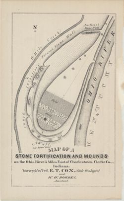
- Subject:
- Geographic Subject: Ohio River, Topical Subject: IGS Annual Reports, Topical Subject: Rivers, Topical Subject: Mounds, Topical Subject: Fortification, Geogra...
- Creator:
- Cox, E. T. (Edward Travers), 1821-1907 and Borden, W. W. (William Wesley), 1823-1906
- Publisher:
- Indiana. Geological Survey
- Date Created:
- 1873
- Identifier:
- VAC3073-M-01542
- Genre:
- Pictorial maps
- Geographic Location:
- Coordinates: W0853723 W0853635 N0382605 N0382513
- Related URL:
- Catalog URL: https://iucat.iu.edu/catalog/18318556
- Abstract:
- Surveyed by Prof. E. T. Cox and W. W. Borden. Pictorial map showing natural and artificial stone walls surrounding fields, timber, and mounds between the Ohi...
- Call Number:
- G4093.C4R4 1873 .C69
- Caption:
- Imprint: Indianapolis : Braden & Burford, Steam Lith., [1873] and Imprint: [Indianapolis] : [Geological Survey of Indiana], [1874]
- Physical Description:
- Dimensions: on sheet 22 x 14 cm and Scale: Scale not given.
- Alternate Identifier:
- Title Control Number: a18318556 and Alternate ID: 390723IP
- Persistent URL:
- https://purl.dlib.indiana.edu/iudl/images/VAC3073/VAC3073-M-01542
- Provenance:
- 5th Annual Report (1873) / Indiana. Geological Survey.
-
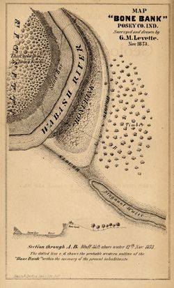
- Subject:
- Geographic Subject: Bone Bank Site (Ind.), Topical Subject: IGS Annual Reports, Geographic Subject: Posey County (Ind.), Topical Subject: Mississippian cultu...
- Creator:
- Levette, G. M. (Gilbert M.)
- Publisher:
- Indiana. Geological Survey
- Date Created:
- 1874
- Identifier:
- VAC3073-M-01540
- Genre:
- Pictorial maps and Geological cross-sections
- Geographic Location:
- Coordinates: W0880126 W0880126 N0374955 N0374955
- Related URL:
- Catalog URL: https://iucat.iu.edu/catalog/18308000
- Abstract:
- 1 map and 1 section on 1 sheet. Surveyed and drawn by G.M. Levette Nov. 1873. Shows the "probable western outline of the 'Bone Bank' within the ...
- Call Number:
- G4093.P6E15 1873 .L48
- Caption:
- Imprint: Inds. : Braden & Burford Steam Lith. [1874] and Imprint: [Indianapolis] : [Geological Survey of Indiana], [1874]
- Physical Description:
- Scale: Not drawn to scale. and Dimensions: on sheet 20 x 12 cm
- Alternate Identifier:
- Alternate ID: 390723IP and Title Control Number: a18308000
- Persistent URL:
- https://purl.dlib.indiana.edu/iudl/images/VAC3073/VAC3073-M-01540
- Provenance:
- 5th Annual Report (1873) / Indiana. Geological Survey.
-
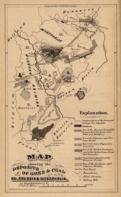
- Subject:
- Geographic Subject: North Rhine-Westphalia (Germany), Topical Subject: IGS Annual Reports, and Topical Subject: Mines and mineral resources
- Creator:
- Hartmann, Hugh
- Publisher:
- Indiana. Geological Survey
- Date Created:
- 1873
- Identifier:
- VAC3073-M-01541
- Genre:
- Geological maps
- Geographic Location:
- Coordinates: E0053400 E0095500 N0522700 N0485600
- Related URL:
- Catalog URL: https://iucat.iu.edu/catalog/18422455
- Abstract:
- Other title: Map showing the deposits of ores and coal in Rhineland Prussia and Westphalia. Shows coal beds and ore deposits by period as well as railroads, ...
- Call Number:
- G6361.H1 1873 .H3
- Caption:
- Imprint: [Indianapolis] [Geological Survey of Indiana], [1873]
- Physical Description:
- Scale: Approximately 1:3,352,800 and Dimensions: 18 x 11 cm
- Alternate Identifier:
- Alternate ID: 390723IP and Title Control Number: a18422455
- Persistent URL:
- https://purl.dlib.indiana.edu/iudl/images/VAC3073/VAC3073-M-01541
- Provenance:
- 5th Annual Report (1873) / Indiana. Geological Survey.

- « Previous
- Next »
- 1
- 2
- 3
- 4