
Search Constraints
You searched for:
Country
СССР (USSR)
Remove constraint Country: СССР (USSR)
Date Created
1933
Remove constraint Date Created: 1933
Publisher
Генеральный штаб РККА
Remove constraint Publisher: Генеральный штаб РККА
1 - 5 of 5
Search Results
-
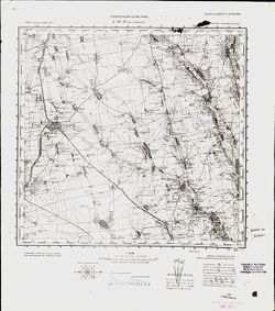
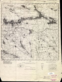
- Description:
- 1929
- Subject:
- Topical Subject: Maps, Topical Subject: Soviet Union, and Geographic Subject: Kopatkevichi
- Publisher:
- Генеральный штаб РККА
- Language:
- Russian
- Date Created:
- 1933
- Identifier:
- VAC9619-004143
- Genre:
- Topographic Maps and Military Maps
- Geographic Location:
- Coordinates: 52, 28.5, 52.333, 29
- Related URL:
- Download GeoTIFF: https://drive.google.com/file/d/1vFmkpV4uQzJmBBUY9p8FqhxDZL8iaKel/view?usp=sharing and Catalog URL: https://iucat.iu.edu/catalog/5020129
- Abstract:
- Modern area represented: Kopatkevichi, Homyel oblast, Belarus
- Call Number:
- G7000 s100 .S7 sheet N-35-142
- Caption:
- Не подлежит оглашению
- City:
- Копаткевичи (Kopatkevichi)
- Copyright Holder:
- No Copyright - United States
- Country:
- СССР (USSR)
- State/Province:
- Белорусская ССР (Byelorussian Soviet Socialist Republic)
- Physical Description:
- Scale: 1:100,000
- Persistent URL:
- http://purl.dlib.indiana.edu/iudl/images/VAC9619/VAC9619-004143
- Provenance:
- DMA Topographic Center, Army Map Service Library, OMAHA
-
- Description:
- 1908
- Subject:
- Topical Subject: Soviet Union, Topical Subject: Maps, and Geographic Subject: Dzyarzhynsk
- Publisher:
- Генеральный штаб РККА
- Language:
- Russian
- Date Created:
- 1933
- Identifier:
- VAC9619-004079
- Genre:
- Military Maps and Topographic Maps
- Geographic Location:
- Coordinates: 53.667, 27, 54, 27.5
- Related URL:
- Catalog URL: https://iucat.iu.edu/catalog/5020129 and Download GeoTIFF: https://drive.google.com/file/d/1tjboYSTp1DC-Rdz2djVaRt-RniRow98d/view?usp=sharing
- Abstract:
- Modern area represented: Dzyarzhynsk, Belarus
- Call Number:
- G7000 s100 .S7 sheet N-35-79
- Caption:
- Не подлежит оглашению
- City:
- Дзержинск (Dzyarzhynsk)
- Copyright Holder:
- No Copyright - United States
- Country:
- Польша (Poland) and СССР (USSR)
- State/Province:
- Белорусская ССР (Byelorussian Soviet Socialist Republic)
- Physical Description:
- Scale: 1:100,000
- Persistent URL:
- http://purl.dlib.indiana.edu/iudl/images/VAC9619/VAC9619-004079
- Provenance:
- DMA Topographic Center, Army Map Service Library, OMAHA
-
- Description:
- 1932
- Subject:
- Geographic Subject: Ovruch, Topical Subject: Soviet Union, and Topical Subject: Maps
- Publisher:
- Генеральный штаб РККА
- Language:
- Russian
- Date Created:
- 1933
- Identifier:
- VAC9619-003112
- Genre:
- Military Maps and Topographic Maps
- Geographic Location:
- Coordinates: 51, 28.5, 51.333, 29
- Related URL:
- Catalog URL: https://iucat.iu.edu/catalog/5020129 and Download GeoTIFF: https://drive.google.com/file/d/1Ux4iL3wR3fHhjgZHVXpIrMLVmUdCl5KE/view?usp=sharing
- Abstract:
- Modern area represented: Ovruch, Ukraine
- Call Number:
- G7000 s100 .S7 sheet M-35-34
- Caption:
- Не подлежит оглашению
- City:
- Овруч (Ovruch)
- Copyright Holder:
- No Copyright - United States
- Country:
- СССР (USSR)
- State/Province:
- Украинская ССР (Ukrainian Soviet Socialist Republic) and Житомирская область (Zhytomyr oblast)
- Physical Description:
- Scale: 1:100,000
- Persistent URL:
- http://purl.dlib.indiana.edu/iudl/images/VAC9619/VAC9619-003112
- Provenance:
- DMA Topographic Center, Army Map Service Library, OMAHA, Library of Congress Geography & Map Division
-
- Description:
- 1929
- Subject:
- Topical Subject: Soviet Union, Topical Subject: Maps, and Geographic Subject: Rozdilna
- Publisher:
- Генеральный штаб РККА
- Language:
- Russian
- Date Created:
- 1933
- Identifier:
- VAC9619-001880
- Genre:
- Topographic Maps and Military Maps
- Geographic Location:
- Coordinates: 46.6667, 30, 47, 30.5
- Related URL:
- Download GeoTIFF: https://drive.google.com/open?id=1UoKPXAXBoUbctkfHhw7v09vU6GsKNUFp and Catalog URL: https://iucat.iu.edu/catalog/5020129
- Abstract:
- Modern area represented: Rozdilna, Odessa oblast, Ukraine
- Call Number:
- G7000 s100 .S7 sheet L-36-37
- Caption:
- Не подлежит оглашению
- City:
- Пос. Раздельная (Posad Pazdelnaya)
- Copyright Holder:
- No Copyright - United States
- Country:
- СССР (USSR)
- State/Province:
- Молдавская АССР (Moldavian Autonomous Soviet Socialist Republic) and Одесская область (Odessa oblast)
- Physical Description:
- Scale: 1:100,000
- Persistent URL:
- http://purl.dlib.indiana.edu/iudl/images/VAC9619/VAC9619-001880
- Provenance:
- CIA Map Library
-
- Description:
- 1927
- Subject:
- Topical Subject: Soviet Union, Topical Subject: Maps, and Geographic Subject: Kryve Ozero
- Publisher:
- Генеральный штаб РККА
- Language:
- Russian
- Date Created:
- 1933
- Identifier:
- VAC9619-001860
- Genre:
- Topographic Maps and Military Maps
- Geographic Location:
- Coordinates: 47.6667, 30, 48, 30.5
- Related URL:
- Catalog URL: https://iucat.iu.edu/catalog/5020129 and Download GeoTIFF: https://drive.google.com/open?id=1hbij6lPaIDBZ6sv_u07NP2w2I0N9ow8M
- Abstract:
- Modern area represented: Kryve Ozero, Mykolaiv oblast, Ukraine
- Call Number:
- G7000 s100 .S7 sheet L-36-1
- Caption:
- Не подлежит оглашению
- City:
- Кривое Озеро (Kryve Ozero)
- Copyright Holder:
- No Copyright - United States
- Country:
- СССР (USSR)
- State/Province:
- Украинская ССР (Ukrainian Soviet Socialist Republic), Одесская область (Odessa oblast), and Молдавская АССР (Moldavian Autonomous Soviet Socialist Republic)
- Physical Description:
- Scale: 1:100,000
- Persistent URL:
- http://purl.dlib.indiana.edu/iudl/images/VAC9619/VAC9619-001860
- Provenance:
- CIA Map Library, Atlasblatt
