
Search Constraints
Search Results
-
![Vanderburgh County [Indiana] preliminary land use map](https://iiif.uits.iu.edu/iiif/2/qf85pf475%2Ffiles%2F018f45ab-c6b4-40b1-9e75-dc08e8ae02ae/full/250,/0/default.jpg)
- Subject:
- Geographic Subject: Vanderburgh County (Ind.) and Topical Subject: Land use
- Creator:
- Vanderburgh County (Ind.). Land Use Planning Committee
- Publisher:
- Vanderburgh County (Ind.). Land Use Planning Committee
- Date Created:
- 1940
- Identifier:
- VAC3073-M-00328
- Genre:
- Thematic maps
- Geographic Location:
- Coordinates: W0874202 W0872657 N0381006 N0374932
- Related URL:
- Catalog URL: https://iucat.iu.edu/catalog/5126629
- Abstract:
- Includes chart showing type of land use, acreage, and recommended use.
- Call Number:
- G4093.V3G4 1940 .V36
- Caption:
- Imprint: [Evansville, Ind.?] : The Committee, [1940?]
- Physical Description:
- Scale: Scale not given. and Dimensions: 26 x 14 cm, on sheet 39 x 28 cm
- Alternate Identifier:
- Title Control Number: a5126629
- Persistent URL:
- https://purl.dlib.indiana.edu/iudl/images/VAC3073/VAC3073-M-00328
-
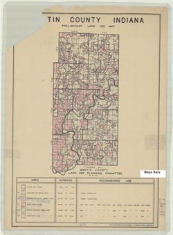
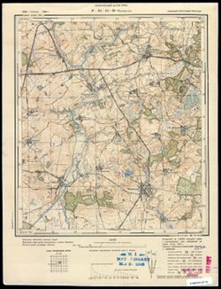
- Subject:
- Geographic Subject: Martin County (Ind.) and Topical Subject: Land use
- Creator:
- Martin County (Ind.). Land Use Planning Committee
- Publisher:
- United States. Bureau of Agricultural Economics
- Date Created:
- 1940
- Identifier:
- VAC3073-M-00782
- Genre:
- Thematic maps
- Geographic Location:
- Coordinates: W0865527 W0864056 N0385416 N0382941
- Related URL:
- Catalog URL: https://iucat.iu.edu/catalog/5126476
- Abstract:
- "Color reproduction by Bureau of Agricultural Economics, U.S.D.A." "8-31-40." Includes chart showing type of land use, acreage, and recom...
- Call Number:
- G4093.M5G4 1940 .M37
- Caption:
- Imprint: [Washington, D.C.?] : U.S. Bureau of Agricultural Economics, [1940]
- Physical Description:
- Scale: Scale not given. and Dimensions: 25 x 12 cm, on sheet 39 x 28 cm
- Alternate Identifier:
- Title Control Number: a5126476
- Persistent URL:
- https://purl.dlib.indiana.edu/iudl/images/VAC3073/VAC3073-M-00782
-
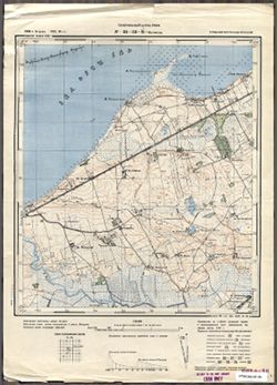
![Harrison County [Indiana] land use map : preliminary](https://iiif.uits.iu.edu/iiif/2/fb495d293%2Ffiles%2Fa6215f59-e4a8-4559-b192-18779587518f/full/250,/0/default.jpg)
- Subject:
- Topical Subject: Land use and Geographic Subject: Harrison County (Ind.)
- Creator:
- Harrison County (Ind.). Land Use Planning Committee
- Publisher:
- Harrison County (Ind.). Land Use Planning Committee
- Date Created:
- 1940
- Identifier:
- VAC3073-M-00901
- Genre:
- Thematic maps
- Geographic Location:
- Coordinates: W0861947 W0855402 N0382521 N0375728
- Related URL:
- Catalog URL: https://iucat.iu.edu/catalog/5126325
- Abstract:
- Includes chart showing type of land use, acreage, and recommended use.
- Call Number:
- G4093.H4G4 1940 .H37
- Caption:
- Imprint: [Corydon, Ind.?] : The Committee, [1940?]
- Physical Description:
- Scale: Scale not given. and Dimensions: 28 x 21 cm, on sheet 39 x 28 cm
- Alternate Identifier:
- Title Control Number: a5126325
- Persistent URL:
- https://purl.dlib.indiana.edu/iudl/images/VAC3073/VAC3073-M-00901
-

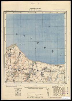
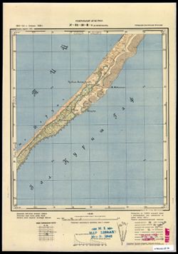
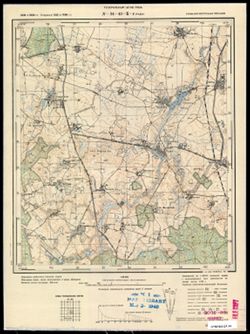
- Description:
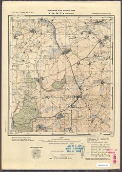
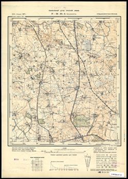
- 1926
- Subject:
- Geographic Subject: Wieleń, Topical Subject: Soviet Union, and Topical Subject: Maps
- Publisher:
- Генеральный штаб Красной Армии
- Language:
- Russian
- Date Created:
- 1940
- Identifier:
- VAC9619-003881
- Genre:
- Topographic Maps and Military Maps
- Geographic Location:
- Coordinates: 52.667, 16, 53, 16.5
- Related URL:
- Catalog URL: https://iucat.iu.edu/catalog/5020129 and Download GeoTIFF: https://drive.google.com/file/d/1e0l5gZYZYukW5-SA95MhoYhbK0LMtX5h/view?usp=sharing
- Abstract:
- Modern area represented: Wieleń, Greater Poland, Poland
- Call Number:
- G7000 s100 .S7 sheet N-33-117
- City:
- Филене (Filehne)
- Copyright Holder:
- No Copyright - United States
- Country:
- Германия (Germany)
- Physical Description:
- Scale: 1:100,000
- Persistent URL:
- http://purl.dlib.indiana.edu/iudl/images/VAC9619/VAC9619-003881
- Provenance:
- DMA Topographic Center, Army Map Service Library, OMAHA, Library of Congress Geography & Map Division
-
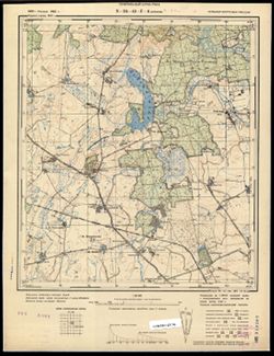
- Description:
- 1893
- Subject:
- Geographic Subject: Ostrowiec Świętokrzyski, Topical Subject: Soviet Union, and Topical Subject: Maps
- Publisher:
- Генеральный штаб Красной Армии
- Language:
- Russian
- Date Created:
- 1940
- Identifier:
- VAC9619-002824
- Genre:
- Topographic Maps and Military Maps
- Geographic Location:
- Coordinates: 50.667, 21, 51, 21.5
- Related URL:
- Download GeoTIFF: https://drive.google.com/file/d/1dCs56aJfHbIoqFvjV3G6y_azZfMDjo25/view?usp=sharing and Catalog URL: https://iucat.iu.edu/catalog/5020129
- Abstract:
- Modern area represented: Ostrowiec Świętokrzyski, Świętokrzyskie province, Poland
- Call Number:
- G7000 s100 .S7 sheet M-34-43
- City:
- Островец (Ostrowiec)
- Copyright Holder:
- No Copyright - United States
- State/Province:
- Область государственных интересов Германии (Region of German state interests)
- Physical Description:
- Scale: 1:100,000
- Persistent URL:
- http://purl.dlib.indiana.edu/iudl/images/VAC9619/VAC9619-002824
- Provenance:
- DMA Topographic Center, OMAHA
-
- Subject:
- Geographic Subject: Gastellovo, Topical Subject: Maps, and Topical Subject: Soviet Union
- Publisher:
- Генеральный штаб Красной Армии
- Language:
- Russian
- Date Created:
- 1940
- Identifier:
- VAC9619-003608
- Genre:
- Military Maps and Topographic Maps
- Geographic Location:
- Coordinates: 55, 21.5, 55.083, 21.625
- Related URL:
- Download GeoTIFF: https://drive.google.com/file/d/1MZqo3Hsc5RDE9S6gTO-v8LULaYz-h7eG/view?usp=sharing and Catalog URL: https://iucat.iu.edu/catalog/14701157
- Abstract:
- Modern area represented: Гастеллово (Gastellovo), Kaliningradskaya oblast, Russia
- Call Number:
- G7063.K2 s25 .S6 sheet N-34-32-C-c
- City:
- Гросс Фридрихсдорф (Gross-Friedrichsdorf)
- Copyright Holder:
- No Copyright - United States
- Country:
- Германия (Восточная Пруссия) (Germany (East Prussia))
- Physical Description:
- Scale: 1:25,000
- Persistent URL:
- http://purl.dlib.indiana.edu/iudl/images/VAC9619/VAC9619-003608
- Provenance:
- M. I. Map Library
-

- Subject:
- Geographic Subject: Pravdino, Topical Subject: Maps, and Topical Subject: Soviet Union
- Publisher:
- Генеральный штаб Красной Армии
- Language:
- Russian
- Date Created:
- 1940
- Identifier:
- VAC9619-003716
- Genre:
- Military Maps and Topographic Maps
- Geographic Location:
- Coordinates: 54.833, 22.5, 54.913, 22.625
- Related URL:
- Download GeoTIFF: https://drive.google.com/file/d/1Pj1DR5fQarxZS6xEnJBWhxqS5OgD1i5X/view?usp=sharing and Catalog URL: https://iucat.iu.edu/catalog/14701157
- Abstract:
- Modern area represented: Правдино (Pravdino), Kaliningradskaya oblast, Russia
- Call Number:
- G7063.K2 s25 .S6 sheet N-34-46-A-c
- City:
- Грумбковсфельде (Grumbkowsfelde)
- Copyright Holder:
- No Copyright - United States
- Country:
- Германия (Восточная Пруссия) (Germany (East Prussia))
- Physical Description:
- Scale: 1:25,000
- Persistent URL:
- http://purl.dlib.indiana.edu/iudl/images/VAC9619/VAC9619-003716
- Provenance:
- CIA Map Branch -- Received
-
- Subject:
- Topical Subject: Maps, Topical Subject: Soviet Union, and Geographic Subject: Vesnovo
- Publisher:
- Генеральный штаб Красной Армии
- Language:
- Russian
- Date Created:
- 1940
- Identifier:
- VAC9619-003711
- Genre:
- Military Maps and Topographic Maps
- Geographic Location:
- Coordinates: 54.75, 22.25, 54.833, 22.375
- Related URL:
- Catalog URL: https://iucat.iu.edu/catalog/14701157 and Download GeoTIFF: https://drive.google.com/file/d/10sCgRzFJLnu0eF0GiQnWqBfZ8ZsS4sKw/view?usp=sharing
- Abstract:
- Modern area represented: Весново (Vesnovo), Kaliningradskaya oblast, Russia
- Call Number:
- G7063.K2 s25 .S6 sheet N-34-45-D-а
- City:
- Куссен (Kussen)
- Copyright Holder:
- No Copyright - United States
- Country:
- Германия (Восточная Пруссия) (Germany (East Prussia))
- Physical Description:
- Scale: 1:25,000
- Persistent URL:
- http://purl.dlib.indiana.edu/iudl/images/VAC9619/VAC9619-003711
- Provenance:
- M. I. Map Library
-

- Subject:
- Topical Subject: Soviet Union, Topical Subject: Maps, and Geographic Subject: Novo-Biyskoye
- Publisher:
- Генеральный штаб РККА
- Language:
- Russian
- Date Created:
- 1940
- Identifier:
- VAC9619-003763
- Genre:
- Military Maps and Topographic Maps
- Geographic Location:
- Coordinates: 54.416667, 21.25, 54.5, 21.375
- Related URL:
- Download GeoTIFF: https://drive.google.com/file/d/12ADQ-KwvRsbz_NrkgrhOE6_uEKunq8Ac/view?usp=sharing and Catalog URL: https://iucat.iu.edu/catalog/14701157
- Abstract:
- Modern area represented: Ново-Бийское (Novo-Biyskoye), Kaliningradskaya oblast, Russia
- Call Number:
- G7063.K2 s25 .S6 sheet N-34-55-D-а
- Caption:
- Captured map
- City:
- Фридрихсвальде (Friedrichswalde)
- Copyright Holder:
- No Copyright - United States
- Country:
- Германия (Восточная Пруссия) (Germany (East Prussia))
- Physical Description:
- Scale: 1:25,000
- Persistent URL:
- http://purl.dlib.indiana.edu/iudl/images/VAC9619/VAC9619-003763
- Provenance:
- Army Map Service Library, OMAHA, Library of Congress Geography & Map Division
-
- Subject:
- Geographic Subject: Zaostrov’ye, Topical Subject: Soviet Union, and Topical Subject: Maps
- Publisher:
- Генеральный штаб РККА
- Language:
- Russian
- Date Created:
- 1940
- Identifier:
- VAC9619-003644
- Genre:
- Military Maps and Topographic Maps
- Geographic Location:
- Coordinates: 54.913, 20.25, 55, 20.375
- Related URL:
- Download GeoTIFF: https://drive.google.com/file/d/1_Rfi01p_uZbHxyLfwbvN0caeO3xUwMzh/view?usp=sharing and Catalog URL: https://iucat.iu.edu/catalog/14701157
- Abstract:
- Modern area represented: Заостровье (Zaostrov’ye), Kaliningradskaya oblast, Russia
- Call Number:
- G7063.K2 s25 .S6 sheet N-34-41-B-a
- City:
- Рантау (Rantau)
- Copyright Holder:
- No Copyright - United States
- Country:
- Германия (Восточная Пруссия) (Germany (East Prussia))
- Physical Description:
- Scale: 1:25,000
- Persistent URL:
- http://purl.dlib.indiana.edu/iudl/images/VAC9619/VAC9619-003644
- Provenance:
- CIA Map Branch -- Received
-
- Subject:
- Topical Subject: Soviet Union, Topical Subject: Maps, and Geographic Subject: Dorozhnyy
- Publisher:
- Генеральный штаб РККА
- Language:
- Russian
- Date Created:
- 1940
- Identifier:
- VAC9619-003653
- Genre:
- Military Maps and Topographic Maps
- Geographic Location:
- Coordinates: 54.75, 20.375, 54.833, 20.5
- Related URL:
- Download GeoTIFF: https://drive.google.com/file/d/1O9LWLzbW4TC8Jmx1-arl8hWMH0L5TBPK/view?usp=sharing and Catalog URL: https://iucat.iu.edu/catalog/14701157
- Abstract:
- Modern area represented: Дорожный (Dorozhnyy), Kaliningradskaya oblast, Russia
- Call Number:
- G7063.K2 s25 .S6 sheet N-34-41-D-b
- City:
- Нойхоф (Neuhof)
- Copyright Holder:
- No Copyright - United States
- Country:
- Германия (Восточная Пруссия) (Germany (East Prussia))
- Physical Description:
- Scale: 1:25,000
- Persistent URL:
- http://purl.dlib.indiana.edu/iudl/images/VAC9619/VAC9619-003653
- Provenance:
- CIA Map Branch -- Received
-
- Description:
- 1891
- Subject:
- Topical Subject: Soviet Union, Topical Subject: Maps, and Geographic Subject: Dragomireşti
- Publisher:
- Генеральный штаб Красной Армии
- Language:
- Russian
- Date Created:
- 1940
- Identifier:
- VAC9619-001755
- Genre:
- Military Maps and Topographic Maps
- Geographic Location:
- Coordinates: 46.3333, 27, 46.6667, 27.5
- Related URL:
- Download GeoTIFF: https://drive.google.com/file/d/1hCPO_hgwRlOoKYWPQdYYSitq_p-y_Ezx/view?usp=sharing and Catalog URL: https://iucat.iu.edu/catalog/5020129
- Abstract:
- Modern area represented: Dragomireşti, Vaslui county, Romania
- Call Number:
- G7000 s100 .S7 sheet L-35-55
- City:
- Драгомирешти (Dragomireşti)
- Copyright Holder:
- No Copyright - United States
- Country:
- Румыния (Romania)
- Physical Description:
- Scale: 1:100,000
- Persistent URL:
- http://purl.dlib.indiana.edu/iudl/images/VAC9619/VAC9619-001755
- Provenance:
- CIA Map Library
-

- Description:
- 1882
- Subject:
- Geographic Subject: Racibórz, Topical Subject: Soviet Union, and Topical Subject: Maps
- Publisher:
- Генеральный штаб Красной Армии
- Language:
- Russian
- Date Created:
- 1940
- Identifier:
- VAC9619-002860
- Genre:
- Military Maps and Topographic Maps
- Geographic Location:
- Coordinates: 50, 18, 50.333, 18.5
- Related URL:
- Download GeoTIFF: https://drive.google.com/file/d/1XcG44qM_SkibVzjFK8EuHetzDeu3O5g7/view?usp=sharing and Catalog URL: https://iucat.iu.edu/catalog/5020129
- Abstract:
- Modern area represented: Racibórz, Silesian province, Poland
- Call Number:
- G7000 s100 .S7 sheet M-34-61
- City:
- Ратибор (Ratibor)
- Copyright Holder:
- No Copyright - United States
- Country:
- Германия (Germany)
- Physical Description:
- Scale: 1:100,000
- Persistent URL:
- http://purl.dlib.indiana.edu/iudl/images/VAC9619/VAC9619-002860
- Provenance:
- DMA Topographic Center, Army Map Service Library, Library of Congress Geography & Map Division
-

- Description:
- 1890
- Subject:
- Topical Subject: Maps, Geographic Subject: Merkinė, and Topical Subject: Soviet Union
- Publisher:
- Генеральный штаб Красной Армии
- Language:
- Russian
- Date Created:
- 1940
- Identifier:
- VAC9619-004062
- Genre:
- Military Maps and Topographic Maps
- Geographic Location:
- Coordinates: 54, 24, 54.333, 24.5
- Related URL:
- Download GeoTIFF: https://drive.google.com/file/d/1y93Q-evfnuFOv1Y5G5Dz9TqcZre99-Eq/view?usp=sharing and Catalog URL: https://iucat.iu.edu/catalog/5020129
- Abstract:
- Modern area represented: Merkinė, Lithuania
- Call Number:
- G7000 s100 .S7 sheet N-35-61
- Caption:
- Для служебного пользования
- City:
- Меречь (Merecz)
- Copyright Holder:
- No Copyright - United States
- Country:
- СССР (USSR)
- State/Province:
- Литовская ССР (Lithuanian Soviet Socialist Republic)
- Physical Description:
- Scale: 1:100,000
- Persistent URL:
- http://purl.dlib.indiana.edu/iudl/images/VAC9619/VAC9619-004062
- Provenance:
- DMA Topographic Center, Army Map Service Library
-
- Description:
- 1891
- Subject:
- Topical Subject: Maps, Topical Subject: Soviet Union, and Geographic Subject: Piotrków Trybunalski
- Publisher:
- Генеральный штаб Красной Армии
- Language:
- Russian
- Date Created:
- 1940
- Identifier:
- VAC9619-002750
- Genre:
- Military Maps and Topographic Maps
- Geographic Location:
- Coordinates: 51.333, 19.5, 51.667, 20
- Related URL:
- Download GeoTIFF: https://drive.google.com/file/d/1wRwSFQwGKu57AUm2kuh8MYECeZZYxWlG/view?usp=sharing and Catalog URL: https://iucat.iu.edu/catalog/5020129
- Abstract:
- Modern area represented: Piotrków Trybunalski, Łódź province, Poland
- Call Number:
- G7000 s100 .S7 sheet M-34-16
- City:
- Пиотркув (Piotrków)
- Copyright Holder:
- No Copyright - United States
- State/Province:
- Область государственных интересов Германии (Region of German state interests)
- Physical Description:
- Scale: 1:100,000
- Persistent URL:
- http://purl.dlib.indiana.edu/iudl/images/VAC9619/VAC9619-002750
- Provenance:
- DMA Topographic Center, Library of Congress Geography & Map Division, Army Map Service Library, Geographic Names Branch, OMAHA
-
- Subject:
- Topical Subject: Soviet Union, Geographic Subject: Mys Ptichiy, and Topical Subject: Maps
- Publisher:
- Генеральный штаб РККА
- Language:
- Russian
- Date Created:
- 1940
- Identifier:
- VAC9619-003589
- Genre:
- Topographic Maps and Military Maps
- Geographic Location:
- Coordinates: 55, 20.625, 55.083, 20.75
- Related URL:
- Catalog URL: https://iucat.iu.edu/catalog/14701157 and Download GeoTIFF: https://drive.google.com/file/d/15WicBKNE8MRo4-2lVtS2fC8rJy6hMY_M/view?usp=sharing
- Abstract:
- Modern area represented: Mys Ptichiy, Kaliningrad oblast, Russia
- Call Number:
- G7063.K2 s25 .S6 sheet N-34-30-C-d
- City:
- Мевенхакен
- Copyright Holder:
- No Copyright - United States
- Country:
- Восточная Пруссия (East Prussia) and Германия (Germany)
- Physical Description:
- Scale: 1:25,000
- Persistent URL:
- http://purl.dlib.indiana.edu/iudl/images/VAC9619/VAC9619-003589
- Provenance:
- M. I. Map Library, G000-30, GS, RA
-

- Description:
- 1938
- Subject:
- Topical Subject: Soviet Union, Geographic Subject: Menyusha, and Topical Subject: Maps
- Publisher:
- Главное управление геодезии и картографии при СНК СССР
- Language:
- Russian
- Date Created:
- 1940
- Identifier:
- VAC9619-002141
- Genre:
- Topographic Maps and Military Maps
- Geographic Location:
- Coordinates: 58.3333, 30.5, 58.6667, 31
- Related URL:
- Download GeoTIFF: https://drive.google.com/open?id=1rAh5vxs28ciqg8ypvRJQ83miA2yO8NTU and Catalog URL: https://iucat.iu.edu/catalog/5020129
- Abstract:
- Modern area represented: Менюша (Menyusha), Novgorodskaya oblast, Russia
- Call Number:
- G7000 s100 .S7 sheet O-36-50
- Caption:
- Captured map and Для служебного пользования
- City:
- Менюши (Menyushi)
- Copyright Holder:
- No Copyright - United States
- Country:
- СССР (USSR)
- State/Province:
- Ленинградская область (Leningrad oblast), Новгородский район (Novgorod district), РСФСР (RSFSR), Батецкий район (Batetsky district), and Шимский район (Shims...
- Physical Description:
- Scale: 1:100,000
- Persistent URL:
- http://purl.dlib.indiana.edu/iudl/images/VAC9619/VAC9619-002141
- Provenance:
- DMA Topographic Center, Army Map Service Library, Library of Congress G & M Division
-
- Description:
- 1939
- Subject:
- Geographic Subject: Əbrəqunus, Topical Subject: Soviet Union, and Topical Subject: Maps
- Publisher:
- Генеральный штаб РККА
- Language:
- Russian
- Date Created:
- 1940
- Identifier:
- VAC9619-000079
- Genre:
- Military Maps and Topographic Maps
- Geographic Location:
- Coordinates: 39, 45.5, 39.1667, 45.75
- Related URL:
- Download GeoTIFF: https://drive.google.com/open?id=1998swVPJ9QtnYo-IMWGIfroqvaOTFJb9 and Catalog URL: http://iucat.iu.edu/catalog/5020131
- Abstract:
- Modern area represented: Əbrəqunus, Azerbaijan
- Call Number:
- G7000 s50 .S68 sheet J-38-32-C
- Caption:
- Не подлежит оглашению
- City:
- Абракунис
- Copyright Holder:
- No Copyright - United States
- Country:
- СССР (USSR)
- State/Province:
- Нахичеванская АССР (Nakhichevan Autonomous Soviet Socialist Republic)
- Physical Description:
- Scale: 1:50,000
- Persistent URL:
- http://purl.dlib.indiana.edu/iudl/images/VAC9619/VAC9619-000079
- Provenance:
- CIA Map Library
-
- Description:
- 1888
- Subject:
- Topical Subject: Maps, Topical Subject: Soviet Union, and Geographic Subject: Głogów
- Publisher:
- Генеральный штаб Красной Армии
- Language:
- Russian
- Date Created:
- 1940
- Identifier:
- VAC9619-002604
- Genre:
- Topographic Maps and Military Maps
- Geographic Location:
- Coordinates: 51.333, 16, 51.667, 16.5
- Related URL:
- Catalog URL: https://iucat.iu.edu/catalog/5020129 and Download GeoTIFF: https://drive.google.com/file/d/132tQw59_UVYPpS2FHIo-f3fPW2xHrIyq/view?usp=sharing
- Abstract:
- Modern area represented: Głogów, Lower Silesian province, Poland
- Call Number:
- G7000 s100 .S7 sheet M-33-21
- City:
- Глогау (Głogów)
- Copyright Holder:
- No Copyright - United States
- Country:
- Германия (Germany)
- Physical Description:
- Scale: 1:100,000
- Persistent URL:
- http://purl.dlib.indiana.edu/iudl/images/VAC9619/VAC9619-002604
- Provenance:
- DMA Topographic Center, Library of Congress G & M Division, Army Map Service Library, OMAHA
-
- Description:
- 1928
- Subject:
- Topical Subject: Soviet Union, Geographic Subject: Chodzież, and Topical Subject: Maps
- Publisher:
- Генеральный штаб Красной Армии
- Language:
- Russian
- Date Created:
- 1940
- Identifier:
- VAC9619-003882
- Genre:
- Topographic Maps and Military Maps
- Geographic Location:
- Coordinates: 52.667, 16.5, 53, 17
- Related URL:
- Catalog URL: https://iucat.iu.edu/catalog/5020129 and Download GeoTIFF: https://drive.google.com/file/d/1mbXeTAsLJggkazCWMm7_Z3Ds-FAy7vz-/view?usp=sharing
- Abstract:
- Modern area represented: Chodzież, Greater Poland, Poland
- Call Number:
- G7000 s100 .S7 sheet N-33-118
- City:
- Кольмар (Kolmar)
- Copyright Holder:
- No Copyright - United States
- Country:
- Германия (Germany)
- Physical Description:
- Scale: 1:100,000
- Persistent URL:
- http://purl.dlib.indiana.edu/iudl/images/VAC9619/VAC9619-003882
- Provenance:
- DMA Topographic Center, Atlasblatt, Army Map Service Library
-
- Description:
- 1894
- Subject:
- Topical Subject: Soviet Union, Topical Subject: Maps, and Geographic Subject: Šilutė
- Publisher:
- Генеральный штаб РККА
- Language:
- Russian
- Date Created:
- 1940
- Identifier:
- VAC9619-003900
- Genre:
- Military Maps and Topographic Maps
- Geographic Location:
- Coordinates: 55.333, 21, 55.667, 21.5
- Related URL:
- Download GeoTIFF: https://drive.google.com/file/d/1RE5ztvBFBVzWdrQ615UuvzpQTXcB95Eb/view?usp=sharing and Catalog URL: https://iucat.iu.edu/catalog/5020129
- Abstract:
- Modern area represented: Šilutė, Klaipėda County, Lithuania
- Call Number:
- G7000 s100 .S7 sheet N-34-19
- City:
- Шилутэ (Šilutė)
- Copyright Holder:
- No Copyright - United States
- Country:
- Германия (Germany) and Литва (Lithuania)
- Physical Description:
- Scale: 1:100,000
- Persistent URL:
- http://purl.dlib.indiana.edu/iudl/images/VAC9619/VAC9619-003900
- Provenance:
- DMA Topographic Center, Army Map Service Library, OMAHA, Geographic Names Branch
-
- Description:
- 1903
- Subject:
- Geographic Subject: Brześć Kujawski, Topical Subject: Soviet Union, and Topical Subject: Maps
- Publisher:
- Генеральный штаб Красной Армии
- Language:
- Russian
- Date Created:
- 1940
- Identifier:
- VAC9619-003986
- Genre:
- Military Maps and Topographic Maps
- Geographic Location:
- Coordinates: 52.333, 18.5, 52.667, 19
- Related URL:
- Download GeoTIFF: https://drive.google.com/file/d/1ePKtNsR6U-PtjSqLwG7MH3wV0p2A9pRF/view?usp=sharing and Catalog URL: https://iucat.iu.edu/catalog/5020129
- Abstract:
- Modern area represented: Brześć Kujawski, Kuyavian-Pomeranian Voivodeship, Poland
- Call Number:
- G7000 s100 .S7 sheet N-34-122
- City:
- Бжесьць Куявски (Brześć Kujawski)
- Copyright Holder:
- No Copyright - United States
- State/Province:
- Область государственных интересов Германии (Region of German state interests)
- Physical Description:
- Scale: 1:100,000
- Persistent URL:
- http://purl.dlib.indiana.edu/iudl/images/VAC9619/VAC9619-003986
- Provenance:
- DMA Topographic Center, Army Map Service Library, OMAHA
-

- Description:
- 1896
- Subject:
- Topical Subject: Soviet Union, Topical Subject: Maps, and Geographic Subject: Târgovişte
- Publisher:
- Генеральный штаб РККА
- Language:
- Russian
- Date Created:
- 1940
- Identifier:
- VAC9619-001699
- Genre:
- Military Maps and Topographic Maps
- Geographic Location:
- Coordinates: 44.6667, 25, 45, 25.5
- Related URL:
- Catalog URL: https://iucat.iu.edu/catalog/5020129 and Download GeoTIFF: https://drive.google.com/open?id=1gMse-lAECHRdjGB57_UtvfIaN-GdoIs9
- Abstract:
- Modern area represented: Târgovişte, Dâmboviţa county, Romania
- Call Number:
- G7000 s100 .S7 sheet L-35-111
- City:
- Тырговиште (Târgovişte)
- Copyright Holder:
- No Copyright - United States
- Country:
- Румыния (Romania)
- Physical Description:
- Scale: 1:100,000
- Persistent URL:
- http://purl.dlib.indiana.edu/iudl/images/VAC9619/VAC9619-001699
- Provenance:
- DMA Topographic Center, Army Map Service Library, OMAHA, Atlasblatt, Library of Congress Geography & Map Division
-
- Description:
- 1885
- Subject:
- Geographic Subject: Milicz, Topical Subject: Soviet Union, and Topical Subject: Maps
- Publisher:
- Генеральный штаб Красной Армии
- Language:
- Russian
- Date Created:
- 1940
- Identifier:
- VAC9619-002606
- Genre:
- Topographic Maps and Military Maps
- Geographic Location:
- Coordinates: 51.333, 17, 51.667, 17.5
- Related URL:
- Download GeoTIFF: https://drive.google.com/file/d/11cAPL6zvsZLMCrE0g3mRTOEqO4lK5fuh/view?usp=sharing and Catalog URL: https://iucat.iu.edu/catalog/5020129
- Abstract:
- Modern area represented: Milicz, Lower Silesian province, Poland
- Call Number:
- G7000 s100 .S7 sheet M-33-23
- City:
- Милич (Milicz)
- Copyright Holder:
- No Copyright - United States
- Country:
- Германия (Germany)
- Physical Description:
- Scale: 1:100,000
- Persistent URL:
- http://purl.dlib.indiana.edu/iudl/images/VAC9619/VAC9619-002606
- Provenance:
- DMA Topographic Center, Library of Congress G & M Division, Army Map Service Library, OMAHA
-

- Description:
- 1890
- Subject:
- Topical Subject: Soviet Union, Topical Subject: Maps, and Geographic Subject: Slonim
- Publisher:
- Генеральный штаб Красной Армии
- Language:
- Russian
- Date Created:
- 1940
- Identifier:
- VAC9619-004100
- Genre:
- Military Maps and Topographic Maps
- Geographic Location:
- Coordinates: 53, 25, 53.333, 25.5
- Related URL:
- Download GeoTIFF: https://drive.google.com/file/d/11uIlcuAi2jRjN2zbDtSfPdBrUot13QKy/view?usp=sharing and Catalog URL: https://iucat.iu.edu/catalog/5020129
- Abstract:
- Modern area represented: Slonim, Belarus
- Call Number:
- G7000 s100 .S7 sheet N-35-99
- City:
- Слоним (Slonim)
- Copyright Holder:
- No Copyright - United States
- Country:
- СССР (USSR)
- State/Province:
- Белорусская ССР (Byelorussian Soviet Socialist Republic) and Барановичская область (Baranavichy oblast)
- Physical Description:
- Scale: 1:100,000
- Persistent URL:
- http://purl.dlib.indiana.edu/iudl/images/VAC9619/VAC9619-004100
- Provenance:
- DMA Topographic Center, Army Map Service Library
-
- Description:
- 1888
- Subject:
- Topical Subject: Soviet Union, Geographic Subject: Września, and Topical Subject: Maps
- Publisher:
- Генеральный штаб Красной Армии
- Language:
- Russian
- Date Created:
- 1940
- Identifier:
- VAC9619-003894
- Genre:
- Topographic Maps and Military Maps
- Geographic Location:
- Coordinates: 52, 17.5, 52.333, 18
- Related URL:
- Download GeoTIFF: https://drive.google.com/file/d/1jINk3uZ8cYVXyvOJ9dmpKF5_AzgIjxmD/view?usp=sharing and Catalog URL: https://iucat.iu.edu/catalog/5020129
- Abstract:
- Modern area represented: Września, Greater Poland, Poland
- Call Number:
- G7000 s100 .S7 sheet N-33-144
- City:
- Врешен (Wreschen)
- Copyright Holder:
- No Copyright - United States
- Country:
- Германия (Germany)
- State/Province:
- Область государственных интересов Германии (Region of German state interests)
- Physical Description:
- Scale: 1:100,000
- Persistent URL:
- http://purl.dlib.indiana.edu/iudl/images/VAC9619/VAC9619-003894
- Provenance:
- DMA Topographic Center, Atlasblatt, Army Map Service Library
-
- Subject:
- Topical Subject: Maps, Geographic Subject: Yudino, and Topical Subject: Soviet Union
- Publisher:
- Генеральный штаб Красной Армии
- Language:
- Russian
- Date Created:
- 1940
- Identifier:
- VAC9619-003771
- Genre:
- Military Maps and Topographic Maps
- Geographic Location:
- Coordinates: 54.625, 21.75, 54.5, 21.875
- Related URL:
- Catalog URL: https://iucat.iu.edu/catalog/14701157 and Download GeoTIFF: https://drive.google.com/file/d/1HICKS0mJ8K-6du3h6Y7YHP-tA74L8hg5/view?usp=sharing
- Abstract:
- Modern area represented: Юдинo (Yudino), Kaliningradskaya oblast, Russia
- Call Number:
- G7063.K2 s25 .S6 sheet N-34-56-D-а
- City:
- Йургайтшен (Jurgaitschen)
- Copyright Holder:
- No Copyright - United States
- Country:
- Германия (Восточная Пруссия) (Germany (East Prussia))
- Physical Description:
- Scale: 1:25,000
- Persistent URL:
- http://purl.dlib.indiana.edu/iudl/images/VAC9619/VAC9619-003771
- Provenance:
- M. I. Map Library
-
- Description:
- 1896
- Subject:
- Topical Subject: Maps, Geographic Subject: Częstochowa, and Topical Subject: Soviet Union
- Publisher:
- Генеральный штаб Красной Армии
- Language:
- Russian
- Date Created:
- 1940
- Identifier:
- VAC9619-002785
- Genre:
- Topographic Maps and Military Maps
- Geographic Location:
- Coordinates: 50.667, 19, 51, 19.5
- Related URL:
- Download GeoTIFF: https://drive.google.com/file/d/1JSRUFZZT-T_7vFoWYJDHWjtDgb0QJurL/view?usp=sharing and Catalog URL: https://iucat.iu.edu/catalog/5020129
- Abstract:
- Modern area represented: Częstochowa, Silesia province, Poland
- Call Number:
- G7000 s100 .S7 sheet M-34-39
- City:
- Ченстохова (Częstochowa)
- Copyright Holder:
- No Copyright - United States
- State/Province:
- Область государственных интересов Германии (Region of German state interests)
- Physical Description:
- Scale: 1:100,000
- Persistent URL:
- http://purl.dlib.indiana.edu/iudl/images/VAC9619/VAC9619-002785
- Provenance:
- DMA Topographic Center, Army Map Service Library, OMAHA
-
- Subject:
- Geographic Subject: Ushakovo, Topical Subject: Soviet Union, and Topical Subject: Maps
- Publisher:
- Генеральный штаб РККА
- Language:
- Russian
- Date Created:
- 1940
- Identifier:
- VAC9619-003736
- Genre:
- Military Maps and Topographic Maps
- Geographic Location:
- Coordinates: 54.583333, 20.25, 54.6667, 20.375
- Related URL:
- Download GeoTIFF: https://drive.google.com/file/d/1PMPgJ10b_4v4k-6FjGMUeU0Jthiq58VT/view?usp=sharing and Catalog URL: https://iucat.iu.edu/catalog/14701157
- Abstract:
- Modern area represented: not marked on the map and the nearest populated place is Ушаково (Ushakovo), former Brandenburg, Kaliningradskaya oblast, Russia
- Call Number:
- G7063.K2 s25 .S6 sheet N-34-53-B-а
- City:
- Тенген (Tengen)
- Copyright Holder:
- No Copyright - United States
- Country:
- Германия (Восточная Пруссия) (Germany (East Prussia))
- Physical Description:
- Scale: 1:25,000
- Persistent URL:
- http://purl.dlib.indiana.edu/iudl/images/VAC9619/VAC9619-003736
- Provenance:
- CIA Map Library
-
- Subject:
- Geographic Subject: Logvino, Topical Subject: Soviet Union, and Topical Subject: Maps
- Publisher:
- Генеральный штаб РККА
- Language:
- Russian
- Date Created:
- 1940
- Identifier:
- VAC9619-003649
- Genre:
- Military Maps and Topographic Maps
- Geographic Location:
- Coordinates: 54.75, 20.125, 54.833, 20.25
- Related URL:
- Catalog URL: https://iucat.iu.edu/catalog/14701157 and Download GeoTIFF: https://drive.google.com/file/d/12OQeiAz__vleYTE7RvBg_NYIOGYf9Qhg/view?usp=sharing
- Abstract:
- Modern area represented: Логвино (Logvino), Kaliningradskaya oblast, Russia
- Call Number:
- G7063.K2 s25 .S6 sheet N-34-41-C-b
- City:
- Меденау (Medenau)
- Copyright Holder:
- No Copyright - United States
- Country:
- Германия (Восточная Пруссия) (Germany (East Prussia))
- Physical Description:
- Scale: 1:25,000
- Persistent URL:
- http://purl.dlib.indiana.edu/iudl/images/VAC9619/VAC9619-003649
- Provenance:
- M. I. Map Library
-
- Subject:
- Geographic Subject: Mel’nikovo, Topical Subject: Soviet Union, and Topical Subject: Maps
- Publisher:
- Генеральный штаб РККА
- Language:
- Russian
- Date Created:
- 1940
- Identifier:
- VAC9619-003647
- Genre:
- Military Maps and Topographic Maps
- Geographic Location:
- Coordinates: 54.833, 20.375, 54.913, 20.5
- Related URL:
- Download GeoTIFF: https://drive.google.com/file/d/1ajWxPW6SILzy7kmX1R-tGPfH470kaeN_/view?usp=sharing and Catalog URL: https://iucat.iu.edu/catalog/14701157
- Abstract:
- Modern area represented: Мельниково (Mel’nikovo), Kaliningradskaya oblast, Russia
- Call Number:
- G7063.K2 s25 .S6 sheet N-34-41-B-d
- City:
- Рудау (Рудау)
- Copyright Holder:
- No Copyright - United States
- Country:
- Германия (Восточная Пруссия) (Germany (East Prussia))
- Physical Description:
- Scale: 1:25,000
- Persistent URL:
- http://purl.dlib.indiana.edu/iudl/images/VAC9619/VAC9619-003647
- Provenance:
- M. I. Map Library
-
- Description:
- 1939
- Subject:
- Geographic Subject: Kamyzyak, Topical Subject: Maps, Topical Subject: Soviet Union, and Geographic Subject: Astrakhan Oblast
- Publisher:
- Наркомрыбпром Главрыбвод
- Language:
- Russian
- Date Created:
- 1940
- Identifier:
- VAC9619-002256
- Genre:
- Military Maps and Topographic Maps
- Geographic Location:
- Coordinates: 46, 48, 46.3333, 48.5
- Related URL:
- Catalog URL: https://iucat.iu.edu/catalog/5020129 and Download GeoTIFF: https://drive.google.com/file/d/1COuEZimX0zDKPsy-a9vlykqgrNjh2Jla/view?usp=sharing
- Abstract:
- Modern area represented: Камызяк (Kamyzyak), Astrakhan Oblast, Russia
- Call Number:
- G7000 s100 .S7 sheet L-39-61
- Caption:
- Рабочий оттиск. Бесплатно. Временное Издание. Для внутреннего использования.
- City:
- Камызяк (Kamyzyak)
- Copyright Holder:
- No Copyright - United States
- Country:
- СССР (USSR)
- State/Province:
- РСФСР (RSFSR) and Сталинградская область (Stalingrad oblast)
- Physical Description:
- Scale: 1:100,000
- Persistent URL:
- http://purl.dlib.indiana.edu/iudl/images/VAC9619/VAC9619-002256
- Provenance:
- DMA Topographic Center, Army Map Service Library
-
- Description:
- 1935
- Subject:
- Topical Subject: Maps, Topical Subject: Soviet Union, and Geographic Subject: Kamyshevatskaya
- Publisher:
- Главное управление геодезии и картографии при СНК СССР
- Language:
- Russian
- Date Created:
- 1940
- Identifier:
- VAC9619-002469
- Genre:
- Topographic Maps and Military Maps
- Geographic Location:
- Coordinates: 46.333, 37.5, 46.667, 38
- Related URL:
- Catalog URL: https://iucat.iu.edu/catalog/5020129 and Download GeoTIFF: https://drive.google.com/file/d/1FZNP0AszmtgO2r8VCGGm5F4L25pPyivc/view?usp=sharing
- Abstract:
- Modern area represented: Kamyshevatskaya, Russia
- Call Number:
- G7000 s100 .S7 sheet L-37-52
- Caption:
- Для служебного пользования
- City:
- Станница Камышеватская (Kamyshevatskaya)
- Copyright Holder:
- No Copyright - United States
- Country:
- СССР (USSR)
- State/Province:
- Краснодарский край (Krasnodar kray) and РСФСР (RSFSR)
- Physical Description:
- Scale: 1:100,000
- Persistent URL:
- http://purl.dlib.indiana.edu/iudl/images/VAC9619/VAC9619-002469
- Provenance:
- DMA Topographic Center, Library of Congress G & M Division, OMAHA, Army Map Service Library
-
- Description:
- 1881
- Subject:
- Topical Subject: Soviet Union, Geographic Subject: Międzyrzec Podlaski, and Topical Subject: Maps
- Publisher:
- Генеральный штаб Красной Армии
- Language:
- Russian
- Date Created:
- 1940
- Identifier:
- VAC9619-002737
- Genre:
- Topographic Maps and Military Maps
- Geographic Location:
- Coordinates: 51.667, 22.5, 52, 23
- Related URL:
- Catalog URL: https://iucat.iu.edu/catalog/5020129 and Download GeoTIFF: https://drive.google.com/file/d/1SNjEsGdllkgt7h9Jz9huDKoA8nylO0H5/view?usp=sharing
- Abstract:
- Modern area represented: Międzyrzec Podlaski, Lublin province, Poland
- Call Number:
- G7000 s100 .S7 sheet M-34-10
- City:
- Мендзыжец (Międzyrzec)
- Copyright Holder:
- No Copyright - United States
- State/Province:
- Область государственных интересов Германии (Region of German state interests)
- Physical Description:
- Scale: 1:100,000
- Persistent URL:
- http://purl.dlib.indiana.edu/iudl/images/VAC9619/VAC9619-002737
- Provenance:
- DMA Topographic Center, Library of Congress Geography & Map Division, Army Map Service Library, Auswärtiges Amt. Geographischer Dienst, OMAHA
-
- Description:
- 1895
- Subject:
- Topical Subject: Soviet Union, Topical Subject: Maps, and Geographic Subject: Novaya Mysh
- Publisher:
- Генеральный штаб Красной Армии
- Language:
- Russian
- Date Created:
- 1940
- Identifier:
- VAC9619-004101
- Genre:
- Military Maps and Topographic Maps
- Geographic Location:
- Coordinates: 53, 25.5, 53.333, 26
- Related URL:
- Download GeoTIFF: https://drive.google.com/file/d/1_U9Fewzw-xMN9DAHx9Kbxa5wSIBHdFy_/view?usp=sharing and Catalog URL: https://iucat.iu.edu/catalog/5020129
- Abstract:
- Modern area represented: Novaya Mysh, Brest oblast, Belarus
- Call Number:
- G7000 s100 .S7 sheet N-35-100
- City:
- Новая Мышь (Novaya Mysh)
- Copyright Holder:
- No Copyright - United States
- Country:
- СССР (USSR)
- State/Province:
- Барановичская область (Baranavichy oblast) and Белорусская ССР (Byelorussian Soviet Socialist Republic)
- Physical Description:
- Scale: 1:100,000
- Persistent URL:
- http://purl.dlib.indiana.edu/iudl/images/VAC9619/VAC9619-004101
- Provenance:
- DMA Topographic Center, Army Map Service Library, OMAHA, Atlasblatt
-

- Description:
- 1938
- Subject:
- Geographic Subject: Nalyuchi, Topical Subject: Soviet Union, and Topical Subject: Maps
- Publisher:
- Главное управление геодезии и картографии при СНК СССР
- Language:
- Russian
- Date Created:
- 1940
- Identifier:
- VAC9619-003525
- Genre:
- Military Maps and Topographic Maps
- Geographic Location:
- Coordinates: 57.66667, 31.75, 57.83333, 32.0
- Related URL:
- Download GeoTIFF: https://drive.google.com/file/d/1sFselxWPujPodWUqJlqPIV8m91n3gL0P/view?usp=sharing and Catalog URL: http://iucat.iu.edu/catalog/5020131
- Abstract:
- Modern area represented: Налючи (Nalyuchi), Novgorodskaya oblast, Russia
- Call Number:
- GM G7000 s50 .S68 sheet O-36-76-D
- Caption:
- Для служебного пользования
- City:
- Налючи (Nalyuchi)
- Copyright Holder:
- No Copyright - United States
- Country:
- СССР (USSR)
- State/Province:
- Лычковский район (Lychkovsky district), Старорусский район (Starorussky district), Демянский район (Demyansky district), Ленинградская область (Leningrad obl...
- Physical Description:
- Scale: 1:50,000
- Persistent URL:
- http://purl.dlib.indiana.edu/iudl/images/VAC9619/VAC9619-003525
- Provenance:
- DMA Topographic Center, Army Map Service Library, OMAHA, Library of Congress Geography & Map Division
-
- Description:
- 1888
- Subject:
- Topical Subject: Soviet Union, Topical Subject: Maps, and Geographic Subject: Hrubieszów
- Publisher:
- Генеральный штаб Красной Армии
- Language:
- Russian
- Date Created:
- 1940
- Identifier:
- VAC9619-002828
- Genre:
- Topographic Maps and Military Maps
- Geographic Location:
- Coordinates: 50.667, 23.5, 51, 24
- Related URL:
- Catalog URL: https://iucat.iu.edu/catalog/5020129 and Download GeoTIFF: https://drive.google.com/file/d/1MtYYusftksd1g2h3UGfdgt847CDumZ60/view?usp=sharing
- Abstract:
- Modern area represented: Hrubieszów, Lublin province, Poland
- Call Number:
- G7000 s100 .S7 sheet M-34-48
- City:
- Грубешув (Hrubieszów)
- Copyright Holder:
- No Copyright - United States
- State/Province:
- Область государственных интересов Германии (Region of German state interests), Волынская область (Volyn oblast), and Украинская ССР (Ukrainian Soviet Sociali...
- Physical Description:
- Scale: 1:100,000
- Persistent URL:
- http://purl.dlib.indiana.edu/iudl/images/VAC9619/VAC9619-002828
- Provenance:
- DMA Topographic Center, Army Map Service Library, OMAHA
-
- Description:
- 1889
- Subject:
- Topical Subject: Soviet Union, Geographic Subject: Leba, and Topical Subject: Maps
- Publisher:
- Генеральный штаб Красной Армии
- Language:
- Russian
- Date Created:
- 1940
- Identifier:
- VAC9619-003562
- Genre:
- Topographic Maps and Military Maps
- Geographic Location:
- Coordinates: 54.667, 17.5, 55, 18
- Related URL:
- Catalog URL: https://iucat.iu.edu/catalog/5020129 and Download GeoTIFF: https://drive.google.com/file/d/1yf4uFfcHKh3Kooi-on2xUzOsWHbfo8jL/view?usp=sharing
- Abstract:
- Modern area represented: Leba, Pomerania province, Poland
- Call Number:
- G7000 s100 .S7 sheet N-33-48
- City:
- Леба (Leba)
- Copyright Holder:
- No Copyright - United States
- Country:
- Германия (Germany)
- Physical Description:
- Scale: 1:100,000
- Persistent URL:
- http://purl.dlib.indiana.edu/iudl/images/VAC9619/VAC9619-003562
- Provenance:
- DMA Topographic Center, Army Map Service Library, Geographic Names Branch
-
- Description:
- 1901
- Subject:
- Topical Subject: Maps, Topical Subject: Soviet Union, and Geographic Subject: Myślenice
- Publisher:
- Генеральный штаб Красной Армии
- Language:
- Russian
- Date Created:
- 1940
- Identifier:
- VAC9619-002872
- Genre:
- Topographic Maps and Military Maps
- Geographic Location:
- Coordinates: 49.667, 19.5, 50, 20
- Related URL:
- Download GeoTIFF: https://drive.google.com/file/d/1i8W5Rov2G2PC8B-kAt5IGRNa_NTKCPlr/view?usp=sharing and Catalog URL: https://iucat.iu.edu/catalog/5020129
- Abstract:
- Modern area represented: Myślenice, Lesser Poland province, Poland
- Call Number:
- G7000 s100 .S7 sheet M-34-76
- City:
- Мысьленице (Myślenice)
- Copyright Holder:
- No Copyright - United States
- State/Province:
- Область государственных интересов Германии (Region of German state interests)
- Physical Description:
- Scale: 1:100,000
- Persistent URL:
- http://purl.dlib.indiana.edu/iudl/images/VAC9619/VAC9619-002872
- Provenance:
- DMA Topographic Center, Army Map Service Library, OMAHA
-
- Description:
- 1938
- Subject:
- Topical Subject: Maps, Topical Subject: Soviet Union, and Geographic Subject: Jurbarkas
- Publisher:
- Генеральный штаб Красной Армии
- Language:
- Russian
- Date Created:
- 1940
- Identifier:
- VAC9619-003909
- Genre:
- Topographic Maps and Military Maps
- Geographic Location:
- Coordinates: 55, 22.5, 55.333, 23
- Related URL:
- Download GeoTIFF: https://drive.google.com/file/d/1NwE6VH28Ue5fWFANc_OUQxYnVn_b62dY/view?usp=sharing and Catalog URL: https://iucat.iu.edu/catalog/5020129
- Abstract:
- Modern area represented: Jurbarkas, Tauragė County, Lithuania
- Call Number:
- G7000 s100 .S7 sheet N-34-34
- Caption:
- Не подлежит оглашению
- City:
- Юрбург (Eurburg)
- Copyright Holder:
- No Copyright - United States
- Country:
- СССР (USSR) and Германия (Germany)
- State/Province:
- Литовская ССР (Lithuanian Soviet Socialist Republic)
- Physical Description:
- Scale: 1:100,000
- Persistent URL:
- http://purl.dlib.indiana.edu/iudl/images/VAC9619/VAC9619-003909
- Provenance:
- DMA Topographic Center, Army Map Service Library, OMAHA, Reichsamt für Landesaufnahme, Kartensammlung
-

- Subject:
- Geographic Subject: Juodkrantė, Topical Subject: Maps, and Topical Subject: Soviet Union
- Publisher:
- Генеральный штаб Красной Армии
- Language:
- Russian
- Date Created:
- 1940
- Identifier:
- VAC9619-003576
- Genre:
- Topographic Maps and Military Maps
- Geographic Location:
- Coordinates: 55.5, 21, 55.583, 21.125
- Related URL:
- Download GeoTIFF: https://drive.google.com/file/d/1cpl0xjbpMukwN0OEFIfjfUMfjJhidcFq/view?usp=sharing and Catalog URL: https://iucat.iu.edu/catalog/14701157
- Abstract:
- Modern area represented: Juodkrantė, Lithuania
- Call Number:
- G7063.K2 s25 .S6 sheet N-34-19-A-c
- City:
- Шварцорт (Shvartsort/Schwarzort)
- Copyright Holder:
- No Copyright - United States
- Country:
- Германия (Восточная Пруссия) (Germany (East Prussia))
- Physical Description:
- Scale: 1:25,000
- Persistent URL:
- http://purl.dlib.indiana.edu/iudl/images/VAC9619/VAC9619-003576
- Provenance:
- M. I. Map Library
-
- Subject:
- Topical Subject: Maps, Geographic Subject: Pamidžio Kopa, and Topical Subject: Soviet Union
- Publisher:
- Генеральный штаб Красной Армии
- Language:
- Russian
- Date Created:
- 1940
- Identifier:
- VAC9619-003584
- Genre:
- Topographic Maps and Military Maps
- Geographic Location:
- Coordinates: 55.25, 20.875, 55.333, 21
- Related URL:
- Catalog URL: https://iucat.iu.edu/catalog/14701157 and Download GeoTIFF: https://drive.google.com/file/d/1m1V0SGipIy0sho-kOLoS7Kg7F_lr0UDu/view?usp=sharing
- Abstract:
- Modern area represented: Pamidžio Kopa, Lithuania
- Call Number:
- G7063.K2 s25 .S6 sheet N-34-30-B-b
- City:
- Парниденер-Берг (Parnidener-Berg)
- Copyright Holder:
- No Copyright - United States
- Country:
- Германия (Восточная Пруссия) (Germany (East Prussia))
- Physical Description:
- Scale: 1:25,000
- Persistent URL:
- http://purl.dlib.indiana.edu/iudl/images/VAC9619/VAC9619-003584
- Provenance:
- M. I. Map Library
-
- Subject:
- Topical Subject: Soviet Union, Topical Subject: Maps, and Geographic Subject: Levoberezhnoye
- Publisher:
- Генеральный штаб Красной Армии
- Language:
- Russian
- Date Created:
- 1940
- Identifier:
- VAC9619-003596
- Genre:
- Military Maps and Topographic Maps
- Geographic Location:
- Coordinates: 55.167, 21.375, 55.25, 21.5
- Related URL:
- Download GeoTIFF: https://drive.google.com/file/d/1dvlY0f2u3s9DuxAwvSM6kSiwi08WRsQD/view?usp=sharing and Catalog URL: https://iucat.iu.edu/catalog/14701157
- Abstract:
- Modern area represented: Левобережное (Levoberezhnoye), Kaliningradskaya oblast, Russia
- Call Number:
- G7063.K2 s25 .S6 sheet N-34-31-B-d
- City:
- Шакунен (Shakunen)
- Copyright Holder:
- No Copyright - United States
- Country:
- Германия (Восточная Пруссия) (Germany (East Prussia))
- Physical Description:
- Scale: 1:25,000
- Persistent URL:
- http://purl.dlib.indiana.edu/iudl/images/VAC9619/VAC9619-003596
- Provenance:
- CIA Map Branch -- Received
-
- Description:
- 1874
- Subject:
- Geographic Subject: Lohja, Topical Subject: Maps, and Topical Subject: Soviet Union
- Publisher:
- Генеральный штаб РККА
- Language:
- Russian
- Date Created:
- 1940
- Identifier:
- VAC9619-002410
- Genre:
- Topographic Maps and Military Maps
- Geographic Location:
- Coordinates: 60, 24, 60.333, 24.5
- Related URL:
- Download GeoTIFF: https://drive.google.com/file/d/1dnOxu46MWpKbH_21PZWbd5RxMkTkgYmo/view?usp=sharing and Catalog URL: https://iucat.iu.edu/catalog/5020129
- Abstract:
- Modern area represented: Lohja, Finland
- Call Number:
- G7000 s100 .S7 sheet P-35-133
- City:
- Лохья (Lohja)
- Copyright Holder:
- No Copyright - United States
- Country:
- Финляндия (Finland)
- Physical Description:
- Scale: 1:100,000
- Persistent URL:
- http://purl.dlib.indiana.edu/iudl/images/VAC9619/VAC9619-002410
- Provenance:
- DMA Topographic Center, Army Map Service Library, Auswärtiges Amt. Geographischer Dienst
-
- Subject:
- Topical Subject: Maps, Topical Subject: Soviet Union, and Geographic Subject: Lunino
- Publisher:
- Генеральный штаб Красной Армии
- Language:
- Russian
- Date Created:
- 1940
- Identifier:
- VAC9619-003699
- Genre:
- Military Maps and Topographic Maps
- Geographic Location:
- Coordinates: 54.913, 22, 55, 22.125
- Related URL:
- Download GeoTIFF: https://drive.google.com/file/d/1bHNg9FqA6f7LENY0S9sIpet530SECyBY/view?usp=sharing and Catalog URL: https://iucat.iu.edu/catalog/14701157
- Abstract:
- Modern area represented: Лунино (Lunino), Kaliningradskaya oblast, Russia
- Call Number:
- G7063.K2 s25 .S6 sheet N-34-45-A-а
- City:
- Ленгветен (Lengwethen)
- Copyright Holder:
- No Copyright - United States
- Country:
- Германия (Восточная Пруссия) (Germany (East Prussia))
- Physical Description:
- Scale: 1:25,000
- Persistent URL:
- http://purl.dlib.indiana.edu/iudl/images/VAC9619/VAC9619-003699
- Provenance:
- CIA Map Branch -- Received
-
- Description:
- 1899
- Subject:
- Geographic Subject: Jasło, Topical Subject: Maps, and Topical Subject: Soviet Union
- Publisher:
- Генеральный штаб Красной Армии
- Language:
- Russian
- Date Created:
- 1940
- Identifier:
- VAC9619-003015
- Genre:
- Topographic Maps and Military Maps
- Geographic Location:
- Coordinates: 49.667, 21, 50, 21.5
- Related URL:
- Download GeoTIFF: https://drive.google.com/file/d/1QZb3K1YAe8pH1CvLkhggtJc4ubWnCekj/view?usp=sharing and Catalog URL: https://iucat.iu.edu/catalog/5020129
- Abstract:
- Modern area represented: Jasło, Subcarpathian province, Poland
- Call Number:
- G7000 s100 .S7 sheet M-34-79
- City:
- Ясло (Jasło)
- Copyright Holder:
- No Copyright - United States
- State/Province:
- Область государственных интересов Германии (Region of German state interests)
- Physical Description:
- Scale: 1:100,000
- Persistent URL:
- http://purl.dlib.indiana.edu/iudl/images/VAC9619/VAC9619-003015
- Provenance:
- DMA Topographic Center, Army Map Service Library, OMAHA
-
- Description:
- 1892
- Subject:
- Geographic Subject: Zielona Góra, Topical Subject: Maps, and Topical Subject: Soviet Union
- Publisher:
- Генеральный штаб Красной Армии
- Language:
- Russian
- Date Created:
- 1940
- Identifier:
- VAC9619-002598
- Genre:
- Topographic Maps and Military Maps
- Geographic Location:
- Coordinates: 51.667, 15.5, 52, 16
- Related URL:
- Catalog URL: https://iucat.iu.edu/catalog/5020129 and Download GeoTIFF: https://drive.google.com/file/d/1YDXCIuxj72uPvn2owXZ5x27Al5Zrrwzp/view?usp=sharing
- Abstract:
- Modern area represented: Zielona Góra, Lubusz province, Poland
- Call Number:
- G7000 s100 .S7 sheet M-33-8
- City:
- Грюнберг (Grünberg)
- Copyright Holder:
- No Copyright - United States
- Country:
- Германия (Germany)
- Physical Description:
- Scale: 1:100,000
- Persistent URL:
- http://purl.dlib.indiana.edu/iudl/images/VAC9619/VAC9619-002598
- Provenance:
- DMA Topographic Center, Library of Congress G & M Division, Army Map Service Library, OMAHA
-
- Description:
- 1880
- Subject:
- Geographic Subject: Gmina Jadów, Topical Subject: Soviet Union, and Topical Subject: Maps
- Publisher:
- Генеральный штаб Красной Армии
- Language:
- Russian
- Date Created:
- 1940
- Identifier:
- VAC9619-003991
- Genre:
- Topographic Maps and Military Maps
- Geographic Location:
- Coordinates: 52.333, 21.5, 52.667, 22
- Related URL:
- Download GeoTIFF: https://drive.google.com/file/d/1mtSm9PaMfrTfFHwbr9CyBuoRcAWPtvuV/view?usp=sharing and Catalog URL: https://iucat.iu.edu/catalog/5020129
- Abstract:
- Modern area represented: Gmina Jadów, Masovian Voivodeship, Poland
- Call Number:
- G7000 s100 .S7 sheet N-34-128
- City:
- Ядув (Jadów)
- Copyright Holder:
- No Copyright - United States
- State/Province:
- Область государственных интересов Германии (Region of German state interests)
- Physical Description:
- Scale: 1:100,000
- Persistent URL:
- http://purl.dlib.indiana.edu/iudl/images/VAC9619/VAC9619-003991
- Provenance:
- DMA Topographic Center, Army Map Service Library
-
- Description:
- 1884
- Subject:
- Geographic Subject: Garwolin, Topical Subject: Soviet Union, and Topical Subject: Maps
- Publisher:
- Генеральный штаб Красной Армии
- Language:
- Russian
- Date Created:
- 1940
- Identifier:
- VAC9619-002735
- Genre:
- Military Maps and Topographic Maps
- Geographic Location:
- Coordinates: 51.667, 21.5, 52, 22
- Related URL:
- Catalog URL: https://iucat.iu.edu/catalog/5020129 and Download GeoTIFF: https://drive.google.com/file/d/1Vk4qvBdMGSUWWSywvNV7pqV9F--mv7L6/view?usp=sharing
- Abstract:
- Modern area represented: Garwolin, Mazovia province, Poland
- Call Number:
- G7000 s100 .S7 sheet M-34-8
- City:
- Гарволин (Garwolin)
- Copyright Holder:
- No Copyright - United States
- State/Province:
- Область государственных интересов Германии (Region of German state interests)
- Physical Description:
- Scale: 1:100,000
- Persistent URL:
- http://purl.dlib.indiana.edu/iudl/images/VAC9619/VAC9619-002735
- Provenance:
- DMA Topographic Center, Library of Congress Geography & Map Division, Army Map Service Library, OMAHA
-
- Description:
- 1886
- Subject:
- Topical Subject: Maps, Geographic Subject: Bialystok, and Topical Subject: Soviet Union
- Publisher:
- Генеральный штаб РККА
- Language:
- Russian
- Date Created:
- 1940
- Identifier:
- VAC9619-003972
- Genre:
- Topographic Maps and Military Maps
- Geographic Location:
- Coordinates: 53, 23, 53.333, 23.5
- Related URL:
- Catalog URL: https://iucat.iu.edu/catalog/5020129 and Download GeoTIFF: https://drive.google.com/file/d/1or9XENpi_EE2ArngZQ57HYq1cIvvkkug/view?usp=sharing
- Abstract:
- Modern area represented: Bialystok, Podlaskie Voivodeship, Poland
- Call Number:
- G7000 s100 .S7 sheet N-34-107
- City:
- Белосток (Bialystok)
- Copyright Holder:
- No Copyright - United States
- Country:
- СССР (USSR)
- State/Province:
- Белостокская область (Belastok oblast) and Белорусская ССР (Byelorussian Soviet Socialist Republic)
- Physical Description:
- Scale: 1:100,000
- Persistent URL:
- http://purl.dlib.indiana.edu/iudl/images/VAC9619/VAC9619-003972
- Provenance:
- DMA Topographic Center, Army Map Service Library, Auswärtiges Amt. Geographischer Dienst
-
- Description:
- 1906
- Subject:
- Geographic Subject: Kwidzyn, Topical Subject: Maps, and Topical Subject: Soviet Union
- Publisher:
- Генеральный штаб Красной Армии
- Language:
- Russian
- Date Created:
- 1940
- Identifier:
- VAC9619-003942
- Genre:
- Military Maps and Topographic Maps
- Geographic Location:
- Coordinates: 53.667, 18.5, 54, 19
- Related URL:
- Catalog URL: https://iucat.iu.edu/catalog/5020129 and Download GeoTIFF: https://drive.google.com/file/d/1-5kDJDDNJLlI47BNm9MrRQ7Mg5I3rMnI/view?usp=sharing
- Abstract:
- Modern area represented: Kwidzyn, Pomeranian voivodeship, Poland
- Call Number:
- G7000 s100 .S7 sheet N-34-74
- City:
- Мариенвердер (Marienwerder)
- Copyright Holder:
- No Copyright - United States
- Country:
- Германия (Germany)
- Physical Description:
- Scale: 1:100,000
- Persistent URL:
- http://purl.dlib.indiana.edu/iudl/images/VAC9619/VAC9619-003942
- Provenance:
- DMA Topographic Center, Army Map Service Library
-

- Subject:
- Geographic Subject: Znamensk, Topical Subject: Soviet Union, and Topical Subject: Maps
- Publisher:
- Генеральный штаб РККА
- Language:
- Russian
- Date Created:
- 1940
- Identifier:
- VAC9619-003752
- Genre:
- Military Maps and Topographic Maps
- Geographic Location:
- Coordinates: 54.583333.21.125, 54.66667, 21.25
- Related URL:
- Catalog URL: https://iucat.iu.edu/catalog/14701157 and Download GeoTIFF: https://drive.google.com/file/d/1Z7tlYRGDlqOydlvt9TBgXz9ShcoNbKej/view?usp=sharing
- Abstract:
- Modern area represented: Знаменск (Znamensk), Kaliningradskaya oblast, Russia
- Call Number:
- G7063.K2 s25 .S6 sheet N-34-55-A-b
- Caption:
- Captured map
- City:
- Велау (Wehlau)
- Copyright Holder:
- No Copyright - United States
- Country:
- Германия (Восточная Пруссия) (Germany (East Prussia))
- Physical Description:
- Scale: 1:25,000
- Persistent URL:
- http://purl.dlib.indiana.edu/iudl/images/VAC9619/VAC9619-003752
- Provenance:
- DMA Topographic Center, Army Map Service Library, Library of Congress Geography & Map Division
-
- Description:
- 1881
- Subject:
- Topical Subject: Soviet Union, Topical Subject: Maps, and Geographic Subject: Czeremcha
- Publisher:
- Генеральный штаб Красной Армии
- Language:
- Russian
- Date Created:
- 1940
- Identifier:
- VAC9619-003993
- Genre:
- Military Maps and Topographic Maps
- Geographic Location:
- Coordinates: 52.333, 23, 52.667, 23.5
- Related URL:
- Download GeoTIFF: https://drive.google.com/file/d/1kPiXT7F_LZnyau0SUjehrYKXx17IX5X1/view?usp=sharing and Catalog URL: https://iucat.iu.edu/catalog/5020129
- Abstract:
- Modern area represented: Czeremcha, Podlaskie Voivodeship, Poland
- Call Number:
- G7000 s100 .S7 sheet N-34-131
- City:
- Черемха (Czeremcha)
- Copyright Holder:
- No Copyright - United States
- Country:
- СССР (USSR)
- State/Province:
- Область государственных интересов Германии (Region of German state interests), Белостокская область (Belastok oblast), Белорусская ССР (Byelorussian Soviet S...
- Physical Description:
- Scale: 1:100,000
- Persistent URL:
- http://purl.dlib.indiana.edu/iudl/images/VAC9619/VAC9619-003993
- Provenance:
- DMA Topographic Center, Army Map Service Library, OMAHA, Library of Congress Geography & Map Division
-
- Description:
- 1887
- Subject:
- Topical Subject: Soviet Union, Geographic Subject: Chełm, and Topical Subject: Maps
- Publisher:
- Генеральный штаб Красной Армии
- Language:
- Russian
- Date Created:
- 1940
- Identifier:
- VAC9619-002782
- Genre:
- Military Maps and Topographic Maps
- Geographic Location:
- Coordinates: 51, 23, 51.333, 23.5
- Related URL:
- Catalog URL: https://iucat.iu.edu/catalog/5020129 and Download GeoTIFF: https://drive.google.com/file/d/1Y9V-_cytuvhxmcWxqlf1B2I7byIrmTaA/view?usp=sharing
- Abstract:
- Modern area represented: Chełm, Lublin province, Poland
- Call Number:
- G7000 s100 .S7 sheet M-34-35
- City:
- Холм (Chełm)
- Copyright Holder:
- No Copyright - United States
- State/Province:
- Область государственных интересов Германии (Region of German state interests)
- Physical Description:
- Scale: 1:100,000
- Persistent URL:
- http://purl.dlib.indiana.edu/iudl/images/VAC9619/VAC9619-002782
- Provenance:
- DMA Topographic Center, Army Map Service Library, OMAHA
-
- Description:
- 1895
- Subject:
- Topical Subject: Soviet Union, Topical Subject: Maps, and Geographic Subject: Jędrzejów
- Publisher:
- Генеральный штаб Красной Армии
- Language:
- Russian
- Date Created:
- 1940
- Identifier:
- VAC9619-002854
- Genre:
- Military Maps and Topographic Maps
- Geographic Location:
- Coordinates: 50.333, 20, 50.667, 20.5
- Related URL:
- Catalog URL: https://iucat.iu.edu/catalog/5020129 and Download GeoTIFF: https://drive.google.com/file/d/1a3ZFZV7QLg3yM0GPS100bYjRs810vrlM/view?usp=sharing
- Abstract:
- Modern area represented: Jędrzejów, Świętokrzyskie province, Poland
- Call Number:
- G7000 s100 .S7 sheet M-34-53
- City:
- Енджеюв (Jędrzejów)
- Copyright Holder:
- No Copyright - United States
- State/Province:
- Область государственных интересов Германии (Region of German state interests)
- Physical Description:
- Scale: 1:100,000
- Persistent URL:
- http://purl.dlib.indiana.edu/iudl/images/VAC9619/VAC9619-002854
- Provenance:
- DMA Topographic Center, Army Map Service Library, Library of Congress Geography & Map Division
-

- Description:
- 1875
- Subject:
- Geographic Subject: Wałcz, Topical Subject: Soviet Union, and Topical Subject: Maps
- Publisher:
- Генеральный штаб Красной Армии
- Language:
- Russian
- Date Created:
- 1940
- Identifier:
- VAC9619-003876
- Genre:
- Military Maps and Topographic Maps
- Geographic Location:
- Coordinates: 53, 16, 53.333, 16.5
- Related URL:
- Catalog URL: https://iucat.iu.edu/catalog/5020129 and Download GeoTIFF: https://drive.google.com/file/d/17jp6fvywukLboFVsZaDUzlXEFduC8Ega/view?usp=sharing
- Abstract:
- Modern area represented: Wałcz, West Pomerania, Poland
- Call Number:
- G7000 s100 .S7 sheet N-33-105
- City:
- Дейч-Кроне (Deutsch Krone)
- Copyright Holder:
- No Copyright - United States
- Country:
- Германия (Germany)
- Physical Description:
- Scale: 1:100,000
- Persistent URL:
- http://purl.dlib.indiana.edu/iudl/images/VAC9619/VAC9619-003876
- Provenance:
- DMA Topographic Center, Auswärtiges Amt. Geographischer Dienst, Army Map Service Library
-
- Description:
- 1924
- Subject:
- Geographic Subject: Szczecinek, Topical Subject: Maps, and Topical Subject: Soviet Union
- Publisher:
- Генеральный штаб Красной Армии
- Language:
- Russian
- Date Created:
- 1940
- Identifier:
- VAC9619-003868
- Genre:
- Military Maps and Topographic Maps
- Geographic Location:
- Coordinates: 53.667, 16.5, 54, 17
- Related URL:
- Catalog URL: https://iucat.iu.edu/catalog/5020129 and Download GeoTIFF: https://drive.google.com/file/d/1snQO_DflCq0ZOLTkYKf6cgtYce4EtyDM/view?usp=sharing
- Abstract:
- Modern area represented: Szczecinek, West Pomerania, Poland
- Call Number:
- G7000 s100 .S7 sheet N-33-82
- City:
- Нойштеттин (Neustettin)
- Copyright Holder:
- No Copyright - United States
- Country:
- Германия (Germany)
- Physical Description:
- Scale: 1:100,000
- Persistent URL:
- http://purl.dlib.indiana.edu/iudl/images/VAC9619/VAC9619-003868
- Provenance:
- DMA Topographic Center, Army Map Service Library, Auswärtiges Amt. Geographischer Dienst
-

- Subject:
- Geographic Subject: Gvardeysk, Topical Subject: Soviet Union, and Topical Subject: Maps
- Publisher:
- Генеральный штаб РККА
- Language:
- Russian
- Date Created:
- 1940
- Identifier:
- VAC9619-003751
- Genre:
- Topographic Maps and Military Maps
- Geographic Location:
- Coordinates: 54.58333, 21.0, 54.6667, 21.125
- Related URL:
- Download GeoTIFF: https://drive.google.com/file/d/1e74kGDF5qBgQZxesWsztwpgEImRgJpYi/view?usp=sharing and Catalog URL: https://iucat.iu.edu/catalog/14701157
- Abstract:
- Modern area represented: Гвардейск (Gvardeysk), Kaliningradskaya oblast, Russia
- Call Number:
- G7063.K2 s25 .S6 sheet N-34-55-A-а
- City:
- Тапиау (Tapiau)
- Copyright Holder:
- No Copyright - United States
- Country:
- Германия (Восточная Пруссия) (Germany (East Prussia))
- Physical Description:
- Scale: 1:25,000
- Persistent URL:
- http://purl.dlib.indiana.edu/iudl/images/VAC9619/VAC9619-003751
- Provenance:
- Army Map Service Library, OMAHA, Library of Congress Geography & Map Division
-
- Description:
- 1876
- Subject:
- Geographic Subject: Kalush, Topical Subject: Soviet Union, and Topical Subject: Maps
- Publisher:
- Генеральный штаб Красной Армии
- Language:
- Russian
- Date Created:
- 1940
- Identifier:
- VAC9619-003240
- Genre:
- Topographic Maps and Military Maps
- Geographic Location:
- Coordinates: 49, 24, 49.333, 24.5
- Related URL:
- Download GeoTIFF: https://drive.google.com/file/d/1pwyJ2a_XgKQaMoiMGPeZCxAByaHD7tMj/view?usp=sharing and Catalog URL: https://iucat.iu.edu/catalog/5020129
- Abstract:
- Modern area represented: Kalush, Ivano-Frankivsk oblast, Ukraine
- Call Number:
- G7000 s100 .S7 sheet M-35-97
- City:
- Калуш (Kalush)
- Copyright Holder:
- No Copyright - United States
- Country:
- СССР (USSR)
- State/Province:
- Львовская область (Lviv oblast), Станиславская область (Stanislav oblast), Украинская ССР (Ukrainian Soviet Socialist Republic), and Дрогобычская область (Dr...
- Physical Description:
- Scale: 1:100,000
- Persistent URL:
- http://purl.dlib.indiana.edu/iudl/images/VAC9619/VAC9619-003240
- Provenance:
- DMA Topographic Center, Army Map Service Library, OMAHA, Atlasblatt
-
- Description:
- 1925
- Subject:
- Topical Subject: Maps, Geographic Subject: Tczew, and Topical Subject: Soviet Union
- Publisher:
- Генеральный штаб Красной Армии
- Language:
- Russian
- Date Created:
- 1940
- Identifier:
- VAC9619-003931
- Genre:
- Military Maps and Topographic Maps
- Geographic Location:
- Coordinates: 54, 18.5, 54.333, 19
- Related URL:
- Download GeoTIFF: https://drive.google.com/file/d/1wmiOysBOQ7SxeeFdFDA7blujWD0900wC/view?usp=sharing and Catalog URL: https://iucat.iu.edu/catalog/5020129
- Abstract:
- Modern area represented: Tczew, Pomerania, Poland
- Call Number:
- G7000 s100 .S7 sheet N-34-62
- City:
- Диршау (Dirschau)
- Copyright Holder:
- No Copyright - United States
- Country:
- Германия (Germany)
- Physical Description:
- Scale: 1:100,000
- Persistent URL:
- http://purl.dlib.indiana.edu/iudl/images/VAC9619/VAC9619-003931
- Provenance:
- DMA Topographic Center, Army Map Service Library, OMAHA
-

- Subject:
- Geographic Subject: Sukhodol’ye, Topical Subject: Soviet Union, and Topical Subject: Maps
- Publisher:
- Генеральный штаб РККА
- Language:
- Russian
- Date Created:
- 1940
- Identifier:
- VAC9619-003757
- Genre:
- Topographic Maps and Military Maps
- Geographic Location:
- Coordinates: 54.5, 21.25, 54.583333, 21.375
- Related URL:
- Download GeoTIFF: https://drive.google.com/file/d/14jGcncKoDrk02oM3Vjf7feRtsNIx-vFJ/view?usp=sharing and Catalog URL: https://iucat.iu.edu/catalog/14701157
- Abstract:
- Modern area represented: Суходолье (Sukhodol’ye), Kaliningradskaya oblast, Russia
- Call Number:
- G7063.K2 s25 .S6 sheet N-34-55-B-c
- City:
- Клайн Нур (Klein Nuhr)
- Copyright Holder:
- No Copyright - United States
- Country:
- Германия (Восточная Пруссия) (Germany (East Prussia))
- Physical Description:
- Scale: 1:25,000
- Persistent URL:
- http://purl.dlib.indiana.edu/iudl/images/VAC9619/VAC9619-003757
- Provenance:
- Army Map Service Library, OMAHA, Library of Congress Geography & Map Division
-
- Description:
- 1899
- Subject:
- Topical Subject: Maps, Topical Subject: Soviet Union, and Geographic Subject: Wieluń
- Publisher:
- Генеральный штаб Красной Армии
- Language:
- Russian
- Date Created:
- 1940
- Identifier:
- VAC9619-002765
- Genre:
- Topographic Maps and Military Maps
- Geographic Location:
- Coordinates: 51, 18.5, 51.333, 19
- Related URL:
- Download GeoTIFF: https://drive.google.com/file/d/1tJFdMQQyPUMK8BZ64oesijhKjBaKF3qZ/view?usp=sharing and Catalog URL: https://iucat.iu.edu/catalog/5020129
- Abstract:
- Modern area represented: Wieluń, Łódź province, Poland
- Call Number:
- G7000 s100 .S7 sheet M-34-26
- City:
- Велюнь (Wieluń)
- Copyright Holder:
- No Copyright - United States
- Country:
- Германия (Germany)
- State/Province:
- Область государственных интересов Германии (Region of German state interests)
- Physical Description:
- Scale: 1:100,000
- Persistent URL:
- http://purl.dlib.indiana.edu/iudl/images/VAC9619/VAC9619-002765
- Provenance:
- DMA Topographic Center, Army Map Service Library, Library of Congress Geography & Map Division, Geographic Names Branch, OMAHA
-
- Subject:
- Topical Subject: Soviet Union, Topical Subject: Maps, and Geographic Subject: Kolno
- Publisher:
- Генеральный штаб Красной Армии
- Language:
- Russian
- Date Created:
- 1940
- Identifier:
- VAC9619-003847
- Genre:
- Military Maps and Topographic Maps
- Geographic Location:
- Coordinates: 53.913, 20.875, 54, 21
- Related URL:
- Download GeoTIFF: https://drive.google.com/file/d/1uStdeTNr1-57qca3X-EimLVaT_kNL9eV/view?usp=sharing and Catalog URL: https://iucat.iu.edu/catalog/14701157
- Abstract:
- Modern area represented: Kolno, Poland
- Call Number:
- G7063.K2 s25 .S6 sheet N-34-78-B-b
- City:
- Гросс Кёллен (Gross Köllen)
- Copyright Holder:
- No Copyright - United States
- Country:
- Германия (Восточная Пруссия) (Germany (East Prussia))
- Physical Description:
- Scale: 1:25,000
- Persistent URL:
- http://purl.dlib.indiana.edu/iudl/images/VAC9619/VAC9619-003847
- Provenance:
- Army Map Service Library, OMAHA, Library of Congress Geography & Map Division
-

- Description:
- 1891
- Subject:
- Topical Subject: Soviet Union, Topical Subject: Maps, and Geographic Subject: Lentvaris
- Publisher:
- Генеральный штаб Красной Армии
- Language:
- Russian
- Date Created:
- 1940
- Identifier:
- VAC9619-004053
- Genre:
- Military Maps and Topographic Maps
- Geographic Location:
- Coordinates: 54.333, 25, 54.667, 25.5
- Related URL:
- Catalog URL: https://iucat.iu.edu/catalog/5020129 and Download GeoTIFF: https://drive.google.com/file/d/1pGDy3t6VgddIj8je6N5NWJd-o0jXgLYB/view?usp=sharing
- Abstract:
- Modern area represented: Lentvaris, Lithuania
- Call Number:
- G7000 s100 .S7 sheet N-35-51
- City:
- Ландворово (Landwarów)
- Copyright Holder:
- No Copyright - United States
- Country:
- СССР (USSR)
- State/Province:
- Белорусская ССР (Byelorussian Soviet Socialist Republic), Барановичская область (Baranavichy oblast), and Литовская ССР (Lithuanian Soviet Socialist Republic)
- Physical Description:
- Scale: 1:100,000
- Persistent URL:
- http://purl.dlib.indiana.edu/iudl/images/VAC9619/VAC9619-004053
- Provenance:
- DMA Topographic Center, Army Map Service Library
-
- Description:
- 1936
- Subject:
- Topical Subject: Maps, Topical Subject: Soviet Union, and Geographic Subject: Alytus
- Publisher:
- Генеральный штаб Красной Армии
- Language:
- Russian
- Date Created:
- 1940
- Identifier:
- VAC9619-004051
- Genre:
- Military Maps and Topographic Maps
- Geographic Location:
- Coordinates: 54.333, 24, 54.667, 24.5
- Related URL:
- Catalog URL: https://iucat.iu.edu/catalog/5020129 and Download GeoTIFF: https://drive.google.com/file/d/1SK5CcJX29MGKemDK61RBn0cUadvQKRN3/view?usp=sharing
- Abstract:
- Modern area represented: Alytus, Lithuania
- Call Number:
- G7000 s100 .S7 sheet N-35-49
- Caption:
- Не подлежит оглашению
- City:
- Алитус (Alytus)
- Copyright Holder:
- No Copyright - United States
- Country:
- СССР (USSR)
- State/Province:
- Литовская ССР (Lithuanian Soviet Socialist Republic)
- Physical Description:
- Scale: 1:100,000
- Persistent URL:
- http://purl.dlib.indiana.edu/iudl/images/VAC9619/VAC9619-004051
- Provenance:
- DMA Topographic Center, Army Map Service Library, OMAHA, Library of Congress Geography & Map Division
-
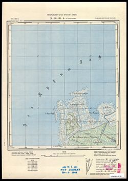
- Description:
- 1911
- Subject:
- Topical Subject: Maps, Topical Subject: Soviet Union, and Geographic Subject: Zaliv Kamyshevyy
- Publisher:
- Генеральный штаб Красной Армии
- Language:
- Russian
- Date Created:
- 1940
- Identifier:
- VAC9619-003592
- Genre:
- Topographic Maps and Military Maps
- Geographic Location:
- Coordinates: 55.167, 21.125, 55.25, 21.25
- Related URL:
- Download GeoTIFF: https://drive.google.com/file/d/1USuVWHSq1lIB27tE-c2qFifs6AeAOsHG/view?usp=sharing and Catalog URL: https://iucat.iu.edu/catalog/14701157
- Abstract:
- Modern area represented: Залив Камышевый (Zaliv Kamyshevyy_, Kaliningraskaya oblast, Russia
- Call Number:
- G7063.K2 s25 .S6 sheet N-34-31-A-d
- City:
- Залив Гаурин (Gaurine)
- Copyright Holder:
- No Copyright - United States
- Country:
- Германия (Восточная Пруссия) (Germany (East Prussia))
- Physical Description:
- Scale: 1:25,000
- Persistent URL:
- http://purl.dlib.indiana.edu/iudl/images/VAC9619/VAC9619-003592
- Provenance:
- M. I. Map Library
-
- Description:
- 1921
- Subject:
- Topical Subject: Maps, Topical Subject: Soviet Union, and Geographic Subject: Pomeranian Voivodeship
- Publisher:
- Генеральный штаб РККА
- Language:
- Russian
- Date Created:
- 1940
- Identifier:
- VAC9619-003869
- Genre:
- Topographic Maps and Military Maps
- Geographic Location:
- Coordinates: 53.667, 17, 54, 17.5
- Related URL:
- Download GeoTIFF: https://drive.google.com/file/d/1ECQb8yIcYW04beF4Fx_4EfgbRIo6n1fH/view?usp=sharing and Catalog URL: https://iucat.iu.edu/catalog/5020129
- Abstract:
- Modern area represented: Pomeranian Voivodeship, Poland
- Call Number:
- G7000 s100 .S7 sheet N-33-83
- City:
- Прехлау (Priechlau)
- Copyright Holder:
- No Copyright - United States
- Country:
- Германия (Germany)
- Physical Description:
- Scale: 1:100,000
- Persistent URL:
- http://purl.dlib.indiana.edu/iudl/images/VAC9619/VAC9619-003869
- Provenance:
- DMA Topographic Center, Army Map Service Library
-
- Subject:
- Geographic Subject: Kamennogorsk, Topical Subject: Soviet Union, and Topical Subject: Maps
- Publisher:
- Генеральный штаб Красной Армии
- Language:
- Russian
- Date Created:
- 1940
- Identifier:
- VAC9619-002396
- Genre:
- Topographic Maps and Military Maps
- Geographic Location:
- Coordinates: 60.667, 29, 61, 29.5
- Related URL:
- Catalog URL: https://iucat.iu.edu/catalog/5020129 and Download GeoTIFF: https://drive.google.com/file/d/1qwxTvuQqhw-LhbzC_Qa27F8g2pcnK7Zs/view?usp=sharing
- Abstract:
- Modern area represented: Каменногорск (Kamennogorsk), Leningradskaya oblast, Russia.
- Call Number:
- G7000 s100 .S7 sheet P-35-119
- Caption:
- Для служебного пользования
- City:
- Антреа (Antrea)
- Copyright Holder:
- No Copyright - United States
- Country:
- СССР (USSR)
- State/Province:
- Карело-Финская ССР (Karelo-Finnish Soviet Socialist Republic)
- Physical Description:
- Scale: 1:100,000
- Persistent URL:
- http://purl.dlib.indiana.edu/iudl/images/VAC9619/VAC9619-002396
- Provenance:
- DMA Topographic Center, Army Map Service Library, OMAHA
-
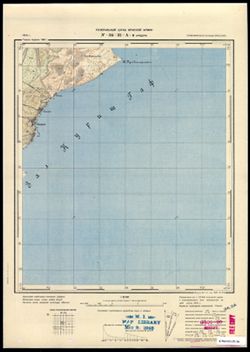
- Description:
- 1910
- Subject:
- Topical Subject: Soviet Union, Topical Subject: Maps, and Geographic Subject: Nida
- Publisher:
- Генеральный штаб Красной Армии
- Language:
- Russian
- Date Created:
- 1940
- Identifier:
- VAC9619-003591
- Genre:
- Topographic Maps and Military Maps
- Geographic Location:
- Coordinates: 55.25, 21, 55.333, 21.125
- Related URL:
- Catalog URL: https://iucat.iu.edu/catalog/14701157 and Download GeoTIFF: https://drive.google.com/file/d/1N5effyxaL1laqoIKkl4KqUYUAqu8zFP5/view?usp=sharing
- Abstract:
- Modern area represented: Nida, Lithuania
- Call Number:
- G7063.K2 s25 .S6 sheet N-34-31-A-a
- City:
- Нидден (Nidden)
- Copyright Holder:
- No Copyright - United States
- Country:
- Германия (Восточная Пруссия) (Germany (East Prussia))
- Physical Description:
- Scale: 1:25,000
- Persistent URL:
- http://purl.dlib.indiana.edu/iudl/images/VAC9619/VAC9619-003591
- Provenance:
- M. I. Map Library
-
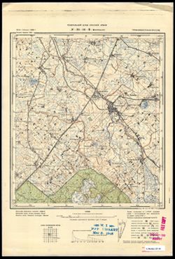
- Subject:
- Topical Subject: Maps, Topical Subject: Soviet Union, and Geographic Subject: Vysokoye
- Publisher:
- Генеральный штаб Красной Армии
- Language:
- Russian
- Date Created:
- 1940
- Identifier:
- VAC9619-003691
- Genre:
- Topographic Maps and Military Maps
- Geographic Location:
- Coordinates: 54.75, 21.5, 54.833, 21.625
- Related URL:
- Catalog URL: https://iucat.iu.edu/catalog/14701157 and Download GeoTIFF: https://drive.google.com/file/d/14U5BZW6jKRHB4242zwUgLBkbVkNZuj46/view?usp=sharing
- Abstract:
- Modern area represented: Высокое (Vysokoye), Kaliningradskaya oblast, Russia
- Call Number:
- G7063.K2 s25 .S6 sheet N-34-44-C-а
- City:
- Попелькен (Popelken)
- Copyright Holder:
- No Copyright - United States
- Country:
- Германия (Восточная Пруссия) (Germany (East Prussia))
- Physical Description:
- Scale: 1:25,000
- Persistent URL:
- http://purl.dlib.indiana.edu/iudl/images/VAC9619/VAC9619-003691
- Provenance:
- M. I. Map Library
-
- Description:
- 1901
- Subject:
- Topical Subject: Soviet Union, Topical Subject: Maps, and Geographic Subject: Lipno
- Publisher:
- Генеральный штаб Красной Армии
- Language:
- Russian
- Date Created:
- 1940
- Identifier:
- VAC9619-003975
- Genre:
- Military Maps and Topographic Maps
- Geographic Location:
- Coordinates: 52.667, 19, 53, 19.5
- Related URL:
- Download GeoTIFF: https://drive.google.com/file/d/1vIfASC507Jo9afctWNeELpAO5bDsfxh8/view?usp=sharing and Catalog URL: https://iucat.iu.edu/catalog/5020129
- Abstract:
- Modern area represented: Lipno, Kuyavian-Pomeranian Voivodeship, Poland
- Call Number:
- G7000 s100 .S7 sheet N-34-111
- City:
- Липно (Lipno)
- Copyright Holder:
- No Copyright - United States
- State/Province:
- Область государственных интересов Германии (Region of German state interests)
- Physical Description:
- Scale: 1:100,000
- Persistent URL:
- http://purl.dlib.indiana.edu/iudl/images/VAC9619/VAC9619-003975
- Provenance:
- DMA Topographic Center, Army Map Service Library
-
- Description:
- 1928
- Subject:
- Topical Subject: Soviet Union, Topical Subject: Maps, and Geographic Subject: Poznań
- Publisher:
- Генеральный штаб Красной Армии
- Language:
- Russian
- Date Created:
- 1940
- Identifier:
- VAC9619-003887
- Genre:
- Military Maps and Topographic Maps
- Geographic Location:
- Coordinates: 52.333, 16.5, 52.667, 17
- Related URL:
- Catalog URL: https://iucat.iu.edu/catalog/5020129 and Download GeoTIFF: https://drive.google.com/file/d/1-CXqNvgO4w50aEz_zTLUOE7uxaKnzQ1m/view?usp=sharing
- Abstract:
- Modern area represented: Poznań, Greater Poland, Poland
- Call Number:
- G7000 s100 .S7 sheet N-33-130
- City:
- Познань (Poznań)
- Copyright Holder:
- No Copyright - United States
- Country:
- Германия (Germany)
- Physical Description:
- Scale: 1:100,000
- Persistent URL:
- http://purl.dlib.indiana.edu/iudl/images/VAC9619/VAC9619-003887
- Provenance:
- DMA Topographic Center, Army Map Service Library, Auswärtiges Amt. Geographischer Dienst
-
- Description:
- 1900
- Subject:
- Geographic Subject: Piteşti, Topical Subject: Soviet Union, and Topical Subject: Maps
- Publisher:
- Генеральный штаб РККА
- Language:
- Russian
- Date Created:
- 1940
- Identifier:
- VAC9619-001691
- Genre:
- Military Maps and Topographic Maps
- Geographic Location:
- Coordinates: 44.6667, 24.5, 45, 25
- Related URL:
- Catalog URL: https://iucat.iu.edu/catalog/5020129 and Download GeoTIFF: https://drive.google.com/open?id=1p0QpTmFIG_U0Hb_evN49aBe5qjLuUXm5
- Abstract:
- Modern area represented: Piteşti, Argeş county, Romania
- Call Number:
- G7000 s100 .S7 sheet L-35-110
- City:
- Питешти (Piteşti)
- Copyright Holder:
- No Copyright - United States
- Country:
- Румыния (Romania)
- Physical Description:
- Scale: 1:100,000
- Persistent URL:
- http://purl.dlib.indiana.edu/iudl/images/VAC9619/VAC9619-001691
- Provenance:
- DMA Topographic Center, Army Map Service Library, Library of Congress Geography & Map Division, Atlasblatt
-
- Description:
- 1932
- Subject:
- Topical Subject: Maps, Geographic Subject: Bondarivka, and Topical Subject: Soviet Union
- Publisher:
- Генеральный штаб РККА
- Language:
- Russian
- Date Created:
- 1940
- Identifier:
- VAC9619-003118
- Genre:
- Military Maps and Topographic Maps
- Geographic Location:
- Coordinates: 50.667, 28, 51, 28.5
- Related URL:
- Download GeoTIFF: https://drive.google.com/file/d/1K11mFVkk-iq0dafstl-xc8YcchJ2tvCC/view?usp=sharing and Catalog URL: https://iucat.iu.edu/catalog/5020129
- Abstract:
- Modern area represented: Bondarivka, Zhytomyr oblast, Ukraine
- Call Number:
- G7000 s100 .S7 sheet M-35-45
- Caption:
- Не подлежит оглашению
- City:
- Бондаревка (Bondarivka)
- Copyright Holder:
- No Copyright - United States
- Country:
- СССР (USSR)
- State/Province:
- Украинская ССР (Ukrainian Soviet Socialist Republic) and Житомирская область (Zhytomyr oblast)
- Physical Description:
- Scale: 1:100,000
- Persistent URL:
- http://purl.dlib.indiana.edu/iudl/images/VAC9619/VAC9619-003118
- Provenance:
- DMA Topographic Center, Army Map Service Library, OMAHA
-
- Description:
- 1889
- Subject:
- Topical Subject: Maps, Topical Subject: Soviet Union, and Geographic Subject: Leszno
- Publisher:
- Генеральный штаб Красной Армии
- Language:
- Russian
- Date Created:
- 1940
- Identifier:
- VAC9619-002600
- Genre:
- Topographic Maps and Military Maps
- Geographic Location:
- Coordinates: 51.667, 16.5, 52, 17
- Related URL:
- Download GeoTIFF: https://drive.google.com/file/d/1qcz3KhHAqPFsX6CtdfiqqCVVuuFvfkOb/view?usp=sharing and Catalog URL: https://iucat.iu.edu/catalog/5020129
- Abstract:
- Modern area represented: Leszno, Greater Poland province, Poland
- Call Number:
- G7000 s100 .S7 sheet M-33-10
- City:
- Лисса (Lissa)
- Copyright Holder:
- No Copyright - United States
- Country:
- Германия (Germany)
- Physical Description:
- Scale: 1:100,000
- Persistent URL:
- http://purl.dlib.indiana.edu/iudl/images/VAC9619/VAC9619-002600
- Provenance:
- DMA Topographic Center, Library of Congress G & M Division, Army Map Service Library, OMAHA
-
- Description:
- 1935
- Subject:
- Topical Subject: Soviet Union, Geographic Subject: Yasenskaya, and Topical Subject: Maps
- Publisher:
- Генеральный штаб Красной Армии
- Language:
- Russian
- Date Created:
- 1940
- Identifier:
- VAC9619-002320
- Genre:
- Military Maps and Topographic Maps
- Geographic Location:
- Coordinates: 46.3333, 38, 46.6667, 38.5
- Related URL:
- Catalog URL: https://iucat.iu.edu/catalog/5020129 and Download GeoTIFF: https://drive.google.com/file/d/1ANfBQuPlscLZ3TLWYKArV4_UX4oV-Ab6/view?usp=sharing
- Abstract:
- Modern area represented: Yasenskaya, Russia
- Call Number:
- G7000 s100 .S7 sheet L-37-53
- Caption:
- Для служебного пользования
- City:
- Ст-ца Ясенская (Yasenskaya)
- Copyright Holder:
- No Copyright - United States
- Country:
- СССР (USSR)
- State/Province:
- РСФСР (RSFSR) and Краснодарский край (Krasnodar kray)
- Physical Description:
- Scale: 1:100,000
- Persistent URL:
- http://purl.dlib.indiana.edu/iudl/images/VAC9619/VAC9619-002320
- Provenance:
- DMA Topographic Center, Army Map Service Library
-
- Description:
- 1881
- Subject:
- Topical Subject: Soviet Union, Topical Subject: Maps, and Geographic Subject: Bielsk Podlaski
- Publisher:
- Генеральный штаб Красной Армии
- Language:
- Russian
- Date Created:
- 1940
- Identifier:
- VAC9619-003984
- Genre:
- Topographic Maps and Military Maps
- Geographic Location:
- Coordinates: 52.66667, 23.0, 53.0, 23.5
- Related URL:
- Download GeoTIFF: https://drive.google.com/file/d/1A86JaHQlP2KHS39WU0mYi8KFpIIv5SCy/view?usp=sharing and Catalog URL: https://iucat.iu.edu/catalog/5020129
- Abstract:
- Modern area represented: Bielsk Podlaski, Podlaskie Voivodeship, Poland
- Call Number:
- G7000 s100 .S7 sheet N-34-119
- City:
- Бельск (Bielsk)
- Copyright Holder:
- No Copyright - United States
- Country:
- СССР (USSR)
- State/Province:
- Белостокская область (Belastok oblast) and Белорусская ССР (Byelorussian Soviet Socialist Republic)
- Physical Description:
- Scale: 1:100,000
- Persistent URL:
- http://purl.dlib.indiana.edu/iudl/images/VAC9619/VAC9619-003984
- Provenance:
- DMA Topographic Center, Army Map Service Library, OMAHA
-
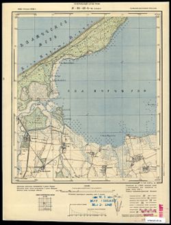
- Subject:
- Topical Subject: Maps, Geographic Subject: Sosnovka, and Topical Subject: Soviet Union
- Publisher:
- Генеральный штаб РККА
- Language:
- Russian
- Date Created:
- 1940
- Identifier:
- VAC9619-003655
- Genre:
- Topographic Maps and Military Maps
- Geographic Location:
- Coordinates: 54.913, 20.5, 55, 20.625
- Related URL:
- Download GeoTIFF: https://drive.google.com/file/d/1UX9Y1lBzSE1zpYf770mAiH2euyoXxO6f/view?usp=sharing and Catalog URL: https://iucat.iu.edu/catalog/14701157
- Abstract:
- Modern area represented: Сосновка (Sosnovka), Kaliningradskaya oblast, Russia
- Call Number:
- G7063.K2 s25 .S6 sheet N-34-42-A-a
- City:
- Бледау (Bledau)
- Copyright Holder:
- No Copyright - United States
- Country:
- Германия (Восточная Пруссия) (Germany (East Prussia))
- Physical Description:
- Scale: 1:25,000
- Persistent URL:
- http://purl.dlib.indiana.edu/iudl/images/VAC9619/VAC9619-003655
- Provenance:
- M. I. Map Library
-
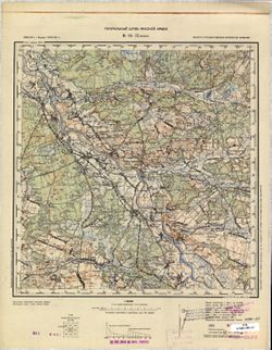
- Description:
- 1892
- Subject:
- Topical Subject: Soviet Union, Topical Subject: Maps, and Geographic Subject: Nisko
- Publisher:
- Генеральный штаб Красной Армии
- Language:
- Russian
- Date Created:
- 1940
- Identifier:
- VAC9619-002858
- Genre:
- Military Maps and Topographic Maps
- Geographic Location:
- Coordinates: 50.333, 22, 50.667, 22.5
- Related URL:
- Catalog URL: https://iucat.iu.edu/catalog/5020129 and Download GeoTIFF: https://drive.google.com/file/d/1d3pXcqZSIlNNtASH5Dg9hJnWboaE_CRO/view?usp=sharing
- Abstract:
- Modern area represented: Nisko, Subcarpathian province, Poland
- Call Number:
- G7000 s100 .S7 sheet M-34-57
- City:
- Ниско (Nisko)
- Copyright Holder:
- No Copyright - United States
- State/Province:
- Область государственных интересов Германии (Region of German state interests)
- Physical Description:
- Scale: 1:100,000
- Persistent URL:
- http://purl.dlib.indiana.edu/iudl/images/VAC9619/VAC9619-002858
- Provenance:
- CIA Map Library, CIA Map Branch -- Received
-
- Description:
- 1938
- Subject:
- Topical Subject: Soviet Union, Topical Subject: Maps, and Geographic Subject: Seredyna-Buda
- Publisher:
- Генеральный штаб Красной Армии
- Language:
- Russian
- Date Created:
- 1940
- Identifier:
- VAC9619-004217
- Genre:
- Military Maps and Topographic Maps
- Geographic Location:
- Coordinates: 52, 34, 52.333, 34.5
- Related URL:
- Download GeoTIFF: https://drive.google.com/file/d/12CMl-5dr0jrOhTKQkJToT1jgUDsmInld/view?usp=sharing and Catalog URL: https://iucat.iu.edu/catalog/5020129
- Abstract:
- Modern area represented: Seredyna-Buda, Sumy oblast, Ukraine
- Call Number:
- G7000 s100 .S7 sheet N-36-141
- City:
- Середина-Буда (Seredyna-Buda)
- Copyright Holder:
- No Copyright - United States
- Country:
- СССР (USSR)
- State/Province:
- РСФСР (RSFSR) and Украинская ССР (Ukrainian Soviet Socialist Republic)
- Physical Description:
- Scale: 1:100,000
- Persistent URL:
- http://purl.dlib.indiana.edu/iudl/images/VAC9619/VAC9619-004217
- Provenance:
- Army Map Service Library, Library of Congress G & M Division
-
- Description:
- 1888
- Subject:
- Geographic Subject: Kościan, Topical Subject: Maps, and Topical Subject: Soviet Union
- Publisher:
- Генеральный штаб Красной Армии
- Language:
- Russian
- Date Created:
- 1940
- Identifier:
- VAC9619-003892
- Genre:
- Military Maps and Topographic Maps
- Geographic Location:
- Coordinates: 52, 16.5, 52.333, 17
- Related URL:
- Catalog URL: https://iucat.iu.edu/catalog/5020129 and Download GeoTIFF: https://drive.google.com/file/d/1mznGLi02tFSckz2sIq8iklzRvm94fNfY/view?usp=sharing
- Abstract:
- Modern area represented: Kościan, Greater Poland, Poland
- Call Number:
- G7000 s100 .S7 sheet N-33-142
- City:
- Костен (Kosten)
- Copyright Holder:
- No Copyright - United States
- Country:
- Германия (Germany)
- Physical Description:
- Scale: 1:100,000
- Persistent URL:
- http://purl.dlib.indiana.edu/iudl/images/VAC9619/VAC9619-003892
- Provenance:
- DMA Topographic Center, Army Map Service Library
-
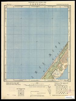
- Description:
- 1910
- Subject:
- Geographic Subject: Gora Vyshka, Topical Subject: Soviet Union, and Topical Subject: Maps
- Publisher:
- Генеральный штаб Красной Армии
- Language:
- Russian
- Date Created:
- 1940
- Identifier:
- VAC9619-003585
- Genre:
- Topographic Maps and Military Maps
- Geographic Location:
- Coordinates: 55.167, 20.75, 55.25, 20.875
- Related URL:
- Download GeoTIFF: https://drive.google.com/file/d/1Kewy2gfGiTYuXyDWBAycNeLEZU9U5CiW/view?usp=sharing and Catalog URL: https://iucat.iu.edu/catalog/14701157
- Abstract:
- Modern area represented: Gora Vyshka, Kaliningrad oblast, Russia
- Call Number:
- G7063.K2 s25 .S6 sheet N-34-30-B-c
- City:
- Предин-Берг (Predinberg)
- Copyright Holder:
- No Copyright - United States
- Country:
- Германия (Germany) and Восточная Пруссия (East Prussia)
- Physical Description:
- Scale: 1:25,000
- Persistent URL:
- http://purl.dlib.indiana.edu/iudl/images/VAC9619/VAC9619-003585
- Provenance:
- CIA Map Branch -- Received, G000-30
-
- Subject:
- Topical Subject: Soviet Union, Geographic Subject: Urochishche Rakitino, and Topical Subject: Maps
- Publisher:
- Генеральный штаб РККА
- Language:
- Russian
- Date Created:
- 1940
- Identifier:
- VAC9619-003638
- Genre:
- Topographic Maps and Military Maps
- Geographic Location:
- Coordinates: 54.75, 19.875, 54.833, 20
- Related URL:
- Catalog URL: https://iucat.iu.edu/catalog/14701157 and Download GeoTIFF: https://drive.google.com/file/d/1FEk7tYmp_00J8YHN6z2jA8d3qQ8A9xzA/view?usp=sharing
- Abstract:
- Modern area represented: Урочище Ракитино (Urochishche Rakitino), Kaliningradskaya oblast, Russia
- Call Number:
- G7063.K2 s25 .S6 sheet N-34-40-D-b
- City:
- Ротенен (Rothenen)
- Copyright Holder:
- No Copyright - United States
- Country:
- Германия (Восточная Пруссия) (Germany (East Prussia))
- Physical Description:
- Scale: 1:25,000
- Persistent URL:
- http://purl.dlib.indiana.edu/iudl/images/VAC9619/VAC9619-003638
- Provenance:
- Army Map Service Library, OMAHA, Library of Congress Geography & Map Division
-
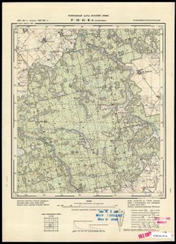
- Subject:
- Geographic Subject: Zagor’yevka, Topical Subject: Soviet Union, and Topical Subject: Maps
- Publisher:
- Генеральный штаб Красной Армии
- Language:
- Russian
- Date Created:
- 1940
- Identifier:
- VAC9619-003709
- Genre:
- Military Maps and Topographic Maps
- Geographic Location:
- Coordinates: 54.667, 22, 54.75, 22.125
- Related URL:
- Download GeoTIFF: https://drive.google.com/file/d/1tFpqXNSPwxaWDfTeqBPRyt2loP85b3bV/view?usp=sharing and Catalog URL: https://iucat.iu.edu/catalog/14701157
- Abstract:
- Modern area represented: not marked on the map. The nearest populated place: Zagor’yevka, Kaliningradskaya oblast, Russia
- Call Number:
- G7063.K2 s25 .S6 sheet N-34-45-C-c
- City:
- Пиллупенен (Pillupöhnen)
- Copyright Holder:
- No Copyright - United States
- Country:
- Германия (Восточная Пруссия) (Germany (East Prussia))
- Physical Description:
- Scale: 1:25,000
- Persistent URL:
- http://purl.dlib.indiana.edu/iudl/images/VAC9619/VAC9619-003709
- Provenance:
- M. I. Map Library
-
- Description:
- 1936
- Subject:
- Topical Subject: Maps, Topical Subject: Soviet Union, and Geographic Subject: Marijampolė
- Publisher:
- Генеральный штаб Красной Армии
- Language:
- Russian
- Date Created:
- 1940
- Identifier:
- VAC9619-003928
- Genre:
- Military Maps and Topographic Maps
- Geographic Location:
- Coordinates: 54.333, 23, 54.667, 23.5
- Related URL:
- Catalog URL: https://iucat.iu.edu/catalog/5020129 and Download GeoTIFF: https://drive.google.com/file/d/1Hz6ITSJfEmKl39IP38wb16C_UiIax_ag/view?usp=sharing
- Abstract:
- Modern area represented: Marijampolė, Marijampolė county, Lithuania
- Call Number:
- G7000 s100 .S7 sheet N-34-59
- Caption:
- Не подлежит оглашению
- City:
- Мариамполь (Marijampolė)
- Copyright Holder:
- No Copyright - United States
- Country:
- СССР (USSR)
- State/Province:
- Литовская ССР (Lithuanian Soviet Socialist Republic) and Область государственных интересов Германии (Region of German state interests)
- Physical Description:
- Scale: 1:100,000
- Persistent URL:
- http://purl.dlib.indiana.edu/iudl/images/VAC9619/VAC9619-003928
- Provenance:
- DMA Topographic Center, Army Map Service Library, OMAHA
-
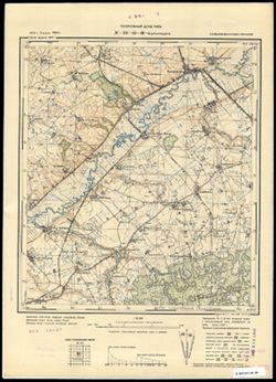
- Subject:
- Topical Subject: Maps, Geographic Subject: Ul'yanovo, and Topical Subject: Soviet Union
- Publisher:
- Генеральный штаб РККА
- Language:
- Russian
- Date Created:
- 1940
- Identifier:
- VAC9619-003707
- Genre:
- Topographic Maps and Military Maps
- Geographic Location:
- Coordinates: 54.75, 22, 54.667, 22.125
- Related URL:
- Catalog URL: https://iucat.iu.edu/catalog/14701157 and Download GeoTIFF: https://drive.google.com/file/d/1qWWDG_2LfmQlhTcUx_rkIBWRT1IzZDhT/view?usp=sharing
- Abstract:
- Modern area represented: Ульяново (Ul'yanovo), Kaliningradskaya oblast, Russia
- Call Number:
- G7063.K2 s25 .S6 sheet N-34-45-C-a
- City:
- Краупишкен (Kraupischken)
- Copyright Holder:
- No Copyright - United States
- Country:
- Германия (Восточная Пруссия) (Germany (East Prussia))
- Physical Description:
- Scale: 1:25,000
- Persistent URL:
- http://purl.dlib.indiana.edu/iudl/images/VAC9619/VAC9619-003707
- Provenance:
- CIA Map Branch -- Received
-
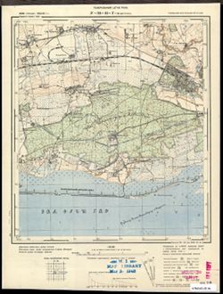
- Subject:
- Topical Subject: Soviet Union, Geographic Subject: Aleksandra Kosmodem’yanskogo, and Topical Subject: Maps
- Publisher:
- Генеральный штаб РККА
- Language:
- Russian
- Date Created:
- 1940
- Identifier:
- VAC9619-003654
- Genre:
- Topographic Maps and Military Maps
- Geographic Location:
- Coordinates: 54.667, 20.25, 54.75, 20.375
- Related URL:
- Catalog URL: https://iucat.iu.edu/catalog/14701157 and Download GeoTIFF: https://drive.google.com/file/d/193K35AFpNdsmNuzDzsY9x3iaQ82U50mL/view?usp=sharing
- Abstract:
- Modern area represented: Александра Космодемьянского (Aleksandra Kosmodem’yanskogo), Kaliningradskaya oblast, Russia
- Call Number:
- G7063.K2 s25 .S6 sheet N-34-41-D-c
- City:
- Метгетен (Metgethen)
- Copyright Holder:
- No Copyright - United States
- Country:
- Германия (Восточная Пруссия) (Germany (East Prussia))
- Physical Description:
- Scale: 1:25,000
- Persistent URL:
- http://purl.dlib.indiana.edu/iudl/images/VAC9619/VAC9619-003654
- Provenance:
- M. I. Map Library
-
- Subject:
- Topical Subject: Maps, Topical Subject: Soviet Union, and Geographic Subject: Rusnė
- Publisher:
- Генеральный штаб Красной Армии
- Language:
- Russian
- Date Created:
- 1940
- Identifier:
- VAC9619-003594
- Genre:
- Military Maps and Topographic Maps
- Geographic Location:
- Coordinates: 55.25, 21.375, 55.333, 21.5
- Related URL:
- Catalog URL: https://iucat.iu.edu/catalog/14701157 and Download GeoTIFF: https://drive.google.com/file/d/1BGNTZ7bt691Ez1fNfdmM-B8Ajhd9kJCT/view?usp=sharing
- Abstract:
- Modern area represented: Rusnė, Lithuania
- Call Number:
- G7063.K2 s25 .S6 sheet N-34-31-B-b
- City:
- Рус (Rus)
- Copyright Holder:
- No Copyright - United States
- Country:
- Германия (Восточная Пруссия) (Germany (East Prussia))
- Physical Description:
- Scale: 1:25,000
- Persistent URL:
- http://purl.dlib.indiana.edu/iudl/images/VAC9619/VAC9619-003594
- Provenance:
- M. I. Map Library
-
- Description:
- 1893
- Subject:
- Topical Subject: Maps, Topical Subject: Soviet Union, and Geographic Subject: Lisichansk
- Publisher:
- Генеральный штаб Красной Армии
- Language:
- Russian
- Date Created:
- 1940
- Identifier:
- VAC9619-003401
- Genre:
- Topographic Maps and Military Maps
- Related URL:
- Catalog URL: https://iucat.iu.edu/catalog/5020129
- Abstract:
- Modern area represented: Lisichansk, Luhansk oblast, Ukraine
- Call Number:
- G7000 s100 .S7 sheet M-37-113
- Caption:
- Для служебного пользования
- City:
- Лисичанск (Lisichansk)
- Copyright Holder:
- No Copyright - United States
- Country:
- СССР (USSR)
- State/Province:
- Сталинская область (Stalino oblast), Украинская ССР (Ukrainian Soviet Socialist Republic), and Ворошиловградская область (Voroshilovgrad oblast)
- Physical Description:
- Scale: 1:100,000
- Persistent URL:
- http://purl.dlib.indiana.edu/iudl/images/VAC9619/VAC9619-003401
- Provenance:
- Army Map Service Library, Library of Congress G & M Division
-
- Description:
- 1928
- Subject:
- Topical Subject: Maps, Geographic Subject: Lębork, and Topical Subject: Soviet Union
- Publisher:
- Генеральный штаб Красной Армии
- Language:
- Russian
- Date Created:
- 1940
- Identifier:
- VAC9619-003566
- Genre:
- Topographic Maps and Military Maps
- Geographic Location:
- Coordinates: 54.333, 17.5, 54.667, 18
- Related URL:
- Catalog URL: https://iucat.iu.edu/catalog/5020129 and Download GeoTIFF: https://drive.google.com/file/d/1r1a8qnvqecdrpNkvLNXWBuPqx767gqkt/view?usp=sharing
- Abstract:
- Modern area represented: Lębork, Pomerania province, Poland
- Call Number:
- G7000 s100 .S7 sheet N-33-60
- City:
- Лауенбург (Lauenburg)
- Copyright Holder:
- No Copyright - United States
- Country:
- Германия (Germany)
- Physical Description:
- Scale: 1:100,000
- Persistent URL:
- http://purl.dlib.indiana.edu/iudl/images/VAC9619/VAC9619-003566
- Provenance:
- DMA Topographic Center, Army Map Service Library, University of Kansas Map Library, Auswärtiges Amt. Geographischer Dienst
-
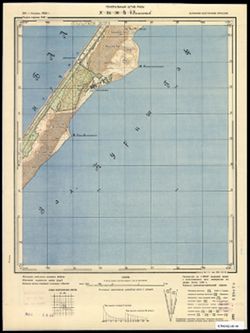
- Subject:
- Topical Subject: Soviet Union, Topical Subject: Maps, and Geographic Subject: Morskoye
- Publisher:
- Генеральный штаб РККА
- Language:
- Russian
- Date Created:
- 1940
- Identifier:
- VAC9619-003586
- Genre:
- Military Maps and Topographic Maps
- Geographic Location:
- Coordinates: 55.167, 20.875, 55.25, 21
- Related URL:
- Catalog URL: https://iucat.iu.edu/catalog/14701157 and Download GeoTIFF: https://drive.google.com/file/d/1Rsb9vB0P3JuEDMdk-KNbVt1oSoBEfUAp/view?usp=sharing
- Abstract:
- Modern area represented: Morskoye, Kaliningrad oblast, Russia
- Call Number:
- G7063.K2 s25 .S6 sheet N-34-30-B-d
- City:
- Пиллкоппен (Pillkoppen)
- Copyright Holder:
- No Copyright - United States
- Country:
- Восточная Пруссия (East Prussia) and Германия (Germany)
- Physical Description:
- Scale: 1:25,000
- Persistent URL:
- http://purl.dlib.indiana.edu/iudl/images/VAC9619/VAC9619-003586
- Provenance:
- CIA Map Branch -- Received, G000-30
-
- Description:
- 1926
- Subject:
- Geographic Subject: Azov, Geographic Subject: Rostov oblast, Topical Subject: Soviet Union, and Topical Subject: Maps
- Publisher:
- Главное управление геодезии и картографии при СНК СССР
- Language:
- Russian
- Date Created:
- 1940
- Identifier:
- VAC9619-002285
- Genre:
- Topographic Maps and Military Maps
- Geographic Location:
- Coordinates: 47, 39, 47.3333, 39.5
- Related URL:
- Download GeoTIFF: https://drive.google.com/file/d/1ZVtvAnypf4ZFXI2NppFs0SerXf00lb1Z/view?usp=sharing and Catalog URL: https://iucat.iu.edu/catalog/5020129
- Abstract:
- Modern area represented: Azov, Russia
- Call Number:
- G7000 s100 .S7 sheet L-37-31
- Caption:
- Для служебного пользования
- City:
- Азов (Azov)
- Copyright Holder:
- No Copyright - United States
- Country:
- СССР (USSR)
- State/Province:
- Ростовская область (Rostov oblast) and РСФСР (RSFSR)
- Physical Description:
- Scale: 1:100,000
- Persistent URL:
- http://purl.dlib.indiana.edu/iudl/images/VAC9619/VAC9619-002285
- Provenance:
- Geographic Names Branch, Heeresplankammer 1. Abt. (Pl. A.) Auslandskartenarchiv
-
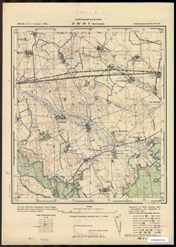
- Subject:
- Geographic Subject: Antonovka, Topical Subject: Soviet Union, and Topical Subject: Maps
- Publisher:
- Генеральный штаб РККА
- Language:
- Russian
- Date Created:
- 1940
- Identifier:
- VAC9619-003665
- Genre:
- Topographic Maps and Military Maps
- Geographic Location:
- Coordinates: 54.75, 20.75, 54.833, 20.875
- Related URL:
- Download GeoTIFF: https://drive.google.com/file/d/1lFS1j0naiFdHz1U8_1wl3dLK_vlNVIQy/view?usp=sharing and Catalog URL: https://iucat.iu.edu/catalog/14701157
- Abstract:
- Modern area represented: Антоновка (Antonovka), Kaliningradskaya oblast, Russia
- Call Number:
- G7063.K2 s25 .S6 sheet N-34-42-D-а
- City:
- Брасдорф (Brasdorf)
- Copyright Holder:
- No Copyright - United States
- Country:
- Германия (Восточная Пруссия) (Germany (East Prussia))
- Physical Description:
- Scale: 1:25,000
- Persistent URL:
- http://purl.dlib.indiana.edu/iudl/images/VAC9619/VAC9619-003665
- Provenance:
- CIA Map Branch -- Received
-
- Description:
- 1874
- Subject:
- Topical Subject: Soviet Union, Topical Subject: Maps, and Geographic Subject: Pyhäjärvi
- Publisher:
- Генеральный штаб РККА
- Language:
- Russian
- Date Created:
- 1940
- Identifier:
- VAC9619-002398
- Genre:
- Military Maps and Topographic Maps
- Geographic Location:
- Coordinates: 60.333, 24, 60.667, 24.5
- Related URL:
- Catalog URL: https://iucat.iu.edu/catalog/5020129 and Download GeoTIFF: https://drive.google.com/file/d/1p9Hzn25uuQJERMheFKeOroS1ZGe_nXsS/view?usp=sharing
- Abstract:
- Modern area represented: Pyhäjärvi, Finland
- Call Number:
- G7000 s100 .S7 sheet P-35-121
- City:
- Пюхяярви (Pyhäjärvi)
- Copyright Holder:
- No Copyright - United States
- Country:
- Финляндия (Finland)
- Physical Description:
- Scale: 1:100,000
- Persistent URL:
- http://purl.dlib.indiana.edu/iudl/images/VAC9619/VAC9619-002398
- Provenance:
- DMA Topographic Center, Army Map Service Library, OMAHA
-
- Subject:
- Topical Subject: Soviet Union, Geographic Subject: Stankiškiai, and Topical Subject: Maps
- Publisher:
- Генеральный штаб Красной Армии
- Language:
- Russian
- Date Created:
- 1940
- Identifier:
- VAC9619-003581
- Genre:
- Military Maps and Topographic Maps
- Geographic Location:
- Coordinates: 55.333, 21.125, 55.417, 21.25
- Related URL:
- Download GeoTIFF: https://drive.google.com/file/d/1WzLj-J4h1Zg1dRJmjt0QaBh4uQl8gFRm/view?usp=sharing and Catalog URL: https://iucat.iu.edu/catalog/14701157
- Abstract:
- Modern area represented: Stankiškiai, Lithuania
- Call Number:
- G7063.K2 s25 .S6 sheet N-34-19-C-d
- Caption:
- Captured map
- City:
- Станкишкен (Stankishken)
- Copyright Holder:
- No Copyright - United States
- Country:
- Германия (Восточная Пруссия) (Germany (East Prussia))
- Physical Description:
- Scale: 1:25,000
- Persistent URL:
- http://purl.dlib.indiana.edu/iudl/images/VAC9619/VAC9619-003581
- Provenance:
- Army Map Service Library
-
- Subject:
- Topical Subject: Soviet Union, Geographic Subject: Prokhladnoye, and Topical Subject: Maps
- Publisher:
- Генеральный штаб Красной Армии
- Language:
- Russian
- Date Created:
- 1940
- Identifier:
- VAC9619-003599
- Genre:
- Topographic Maps and Military Maps
- Geographic Location:
- Coordinates: 55.083, 21.25, 55.167, 21.375
- Related URL:
- Catalog URL: https://iucat.iu.edu/catalog/14701157 and Download GeoTIFF: https://drive.google.com/file/d/1YKY74-2xF2oLvrxWPb4HoNkvYfD7rrvV/view?usp=sharing
- Abstract:
- Modern area represented: Прохладное (Prokhladnoye), Kaliningradskaya oblast, Russia
- Call Number:
- G7063.K2 s25 .S6 sheet N-34-31-D-a
- City:
- Каллнингкен (Kallningken)
- Copyright Holder:
- No Copyright - United States
- Country:
- Германия (Восточная Пруссия) (Germany (East Prussia))
- Physical Description:
- Scale: 1:25,000
- Persistent URL:
- http://purl.dlib.indiana.edu/iudl/images/VAC9619/VAC9619-003599
- Provenance:
- M. I. Map Library
-
- Description:
- 1891
- Subject:
- Topical Subject: Soviet Union, Topical Subject: Maps, and Geographic Subject: Bucharest
- Publisher:
- Генеральный штаб Красной Армии
- Language:
- Russian
- Date Created:
- 1940
- Identifier:
- VAC9619-001794
- Genre:
- Military Maps and Topographic Maps
- Geographic Location:
- Coordinates: 44.3333, 26, 44.6667, 26.5
- Related URL:
- Catalog URL: https://iucat.iu.edu/catalog/5020129 and Download GeoTIFF: https://drive.google.com/open?id=1Qp3MYlVquPkot6GrpfLeHpxTWY4p62PS
- Abstract:
- Modern area represented: Bucharest, Bucureşti county, Romania
- Call Number:
- G7000 s100 .S7 sheet L-35-125
- City:
- Бухарест (Bucharest)
- Copyright Holder:
- No Copyright - United States
- Country:
- Румыния (Romania)
- Physical Description:
- Scale: 1:100,000
- Persistent URL:
- http://purl.dlib.indiana.edu/iudl/images/VAC9619/VAC9619-001794
- Provenance:
- DMA Topographic Center, Army Map Service Library, OMAHA, Library of Congress Geography & Map Division
-
- Subject:
- Topical Subject: Soviet Union, Topical Subject: Maps, and Geographic Subject: Miejska Wieś
- Publisher:
- Генеральный штаб Красной Армии
- Language:
- Russian
- Date Created:
- 1940
- Identifier:
- VAC9619-003846
- Genre:
- Topographic Maps and Military Maps
- Geographic Location:
- Coordinates: 53.913, 20.75, 54, 20.875
- Related URL:
- Catalog URL: https://iucat.iu.edu/catalog/14701157 and Download GeoTIFF: https://drive.google.com/file/d/1WqkOKwlyd7YOTSbtD8mkzjtOpQ3Qs4Dy/view?usp=sharing
- Abstract:
- Modern area represented: Miejska Wieś, Poland
- Call Number:
- G7063.K2 s25 .S6 sheet N-34-78-B-а
- City:
- Бюргерсдорф (Bürgerdorf)
- Copyright Holder:
- No Copyright - United States
- Country:
- Германия (Восточная Пруссия) (Germany (East Prussia))
- Physical Description:
- Scale: 1:25,000
- Persistent URL:
- http://purl.dlib.indiana.edu/iudl/images/VAC9619/VAC9619-003846
- Provenance:
- Army Map Service Library, OMAHA, Library of Congress Geography & Map Division
-
- Subject:
- Topical Subject: Soviet Union, Geographic Subject: Zalivnoye, and Topical Subject: Maps
- Publisher:
- Генеральный штаб РККА
- Language:
- Russian
- Date Created:
- 1940
- Identifier:
- VAC9619-003660
- Genre:
- Military Maps and Topographic Maps
- Geographic Location:
- Coordinates: 54.833, 20.75, 54.913, 20.875
- Related URL:
- Catalog URL: https://iucat.iu.edu/catalog/14701157 and Download GeoTIFF: https://drive.google.com/file/d/1xH82dsY0fzs2LsfQM3IduqqoYKbdHXmu/view?usp=sharing
- Abstract:
- Modern area represented: Заливное (Zalivnoye), Kaliningradskaya oblast, Russia
- Call Number:
- G7063.K2 s25 .S6 sheet N-34-42-B-c
- City:
- Постниккен (Postincken)
- Copyright Holder:
- No Copyright - United States
- Country:
- Германия (Восточная Пруссия) (Germany (East Prussia))
- Physical Description:
- Scale: 1:25,000
- Persistent URL:
- http://purl.dlib.indiana.edu/iudl/images/VAC9619/VAC9619-003660
- Provenance:
- Army Map Service Library, OMAHA, Library of Congress Geography & Map Division
-
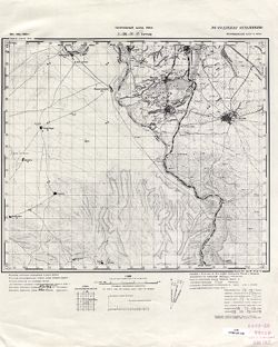
- Subject:
- Geographic Subject: Nehrəm, Topical Subject: Maps, and Topical Subject: Soviet Union
- Publisher:
- Генеральный штаб РККА
- Language:
- Russian
- Date Created:
- 1940
- Identifier:
- VAC9619-000076
- Genre:
- Military Maps and Topographic Maps
- Geographic Location:
- Coordinates: 39, 45.25, 39.1667, 45.5
- Related URL:
- Download GeoTIFF: https://drive.google.com/open?id=1mM1VIpCbqqPPt0FAbm9talybksIlvehj and Catalog URL: http://iucat.iu.edu/catalog/5020131
- Abstract:
- Modern area represented: Nehrəm, Azerbaijan
- Call Number:
- G7000 s50 .S68 sheet J-38-31-D
- Caption:
- Не подлежит оглашению
- City:
- Неграм (Negram)
- Copyright Holder:
- No Copyright - United States
- Country:
- Иран (Iran) and СССР (USSR)
- State/Province:
- Нахичеванская АССР (Nakhichevan Autonomous Soviet Socialist Republic)
- Physical Description:
- Scale: 1:50,000
- Persistent URL:
- http://purl.dlib.indiana.edu/iudl/images/VAC9619/VAC9619-000076
- Provenance:
- CIA Map Library
