
Search Constraints
You searched for:
Publisher
Генеральный штаб Красной Армии
Remove constraint Publisher: Генеральный штаб Красной Армии
State/Province
Область государственных интересов Германии (Region of German state interests)
Remove constraint State/Province: Область государственных интересов Германии (Region of German state interests)
Search Results
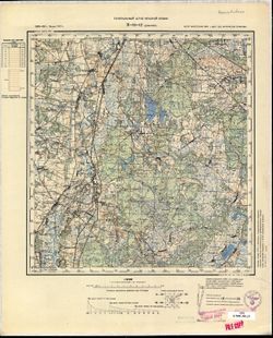
-
- Description:
- 1899
- Subject:
- Topical Subject: Maps, Geographic Subject: Zduńska Wola, and Topical Subject: Soviet Union
- Publisher:
- Генеральный штаб Красной Армии
- Language:
- Russian
- Date Created:
- 1940
- Identifier:
- VAC9619-002746
- Genre:
- Topographic Maps and Military Maps
- Geographic Location:
- Coordinates: 51.333, 18.5, 51.667, 19
- Related URL:
- Catalog URL: https://iucat.iu.edu/catalog/5020129 and Download GeoTIFF: https://drive.google.com/file/d/1-oxgl5dtb6oMWfpmPH_SyUc6lUKKVX_4/view?usp=sharing
- Abstract:
- Modern area represented: Zduńska Wola, Łódź province, Poland
- Call Number:
- G7000 s100 .S7 sheet M-34-14
- City:
- Здуньска Воля (Zduńska Wola)
- Copyright Holder:
- No Copyright - United States
- State/Province:
- Область государственных интересов Германии (Region of German state interests)
- Physical Description:
- Scale: 1:100,000
- Persistent URL:
- http://purl.dlib.indiana.edu/iudl/images/VAC9619/VAC9619-002746
- Provenance:
- DMA Topographic Center, Library of Congress Geography & Map Division, Army Map Service Library, Geographic Names Branch, OMAHA
-
- Description:
- 1888
- Subject:
- Topical Subject: Maps, Geographic Subject: Gmina Błaszki, and Topical Subject: Soviet Union
- Publisher:
- Генеральный штаб Красной Армии
- Language:
- Russian
- Date Created:
- 1940
- Identifier:
- VAC9619-002744
- Genre:
- Military Maps and Topographic Maps
- Geographic Location:
- Coordinates: 51.333, 18, 51.667, 18.5
- Related URL:
- Download GeoTIFF: https://drive.google.com/file/d/1SQp0BLc72f55Sm9zQeg72FX3ionw7K2R/view?usp=sharing and Catalog URL: https://iucat.iu.edu/catalog/5020129
- Abstract:
- Modern area represented: Gmina Błaszki, Łódź province, Poland
- Call Number:
- G7000 s100 .S7 sheet M-34-13
- City:
- Блашки (Błaszki)
- Copyright Holder:
- No Copyright - United States
- Country:
- Германия (Germany)
- State/Province:
- Область государственных интересов Германии (Region of German state interests)
- Physical Description:
- Scale: 1:100,000
- Persistent URL:
- http://purl.dlib.indiana.edu/iudl/images/VAC9619/VAC9619-002744
- Provenance:
- DMA Topographic Center, Library of Congress Geography & Map Division, Army Map Service Library
-
- Description:
- 1886
- Subject:
- Geographic Subject: Damachava, Topical Subject: Soviet Union, and Topical Subject: Maps
- Publisher:
- Генеральный штаб Красной Армии
- Language:
- Russian
- Date Created:
- 1931
- Identifier:
- VAC9619-002741
- Genre:
- Military Maps and Topographic Maps
- Geographic Location:
- Coordinates: 51.667, 23.5, 52, 24
- Related URL:
- Download GeoTIFF: https://drive.google.com/file/d/1-Trah_-vgFFtif-3WIcNxEdhNsP33Yim/view?usp=sharing and Catalog URL: https://iucat.iu.edu/catalog/5020129
- Abstract:
- Modern area represented: Damachava, Brest oblast, Belarus
- Call Number:
- G7000 s100 .S7 sheet M-34-12
- City:
- Домачево (Damachava)
- Copyright Holder:
- No Copyright - United States
- Country:
- СССР (USSR)
- State/Province:
- Брестская область (Brest oblast), Белорусская ССР (Byelorussian Soviet Socialist Republic), and Область государственных интересов Германии (Region of German ...
- Physical Description:
- Scale: 1:100,000
- Persistent URL:
- http://purl.dlib.indiana.edu/iudl/images/VAC9619/VAC9619-002741
- Provenance:
- CIA Map Library, Geographisches Institut der Universität Bonn
-
- Description:
- 1881
- Subject:
- Topical Subject: Maps, Topical Subject: Soviet Union, and Geographic Subject: Łomazy
- Publisher:
- Генеральный штаб Красной Армии
- Language:
- Russian
- Date Created:
- 1940
- Identifier:
- VAC9619-002740
- Genre:
- Topographic Maps and Military Maps
- Geographic Location:
- Coordinates: 51.667, 23, 52, 23.5
- Related URL:
- Catalog URL: https://iucat.iu.edu/catalog/5020129 and Download GeoTIFF: https://drive.google.com/file/d/1NYJuKuKXvTpdnFOtntPApVPL0rrD_A59/view?usp=sharing
- Abstract:
- Modern area represented: Łomazy, Lublin province, Poland
- Call Number:
- G7000 s100 .S7 sheet M-34-11
- City:
- Ломазы (Łomazy)
- Copyright Holder:
- No Copyright - United States
- State/Province:
- Область государственных интересов Германии (Region of German state interests)
- Physical Description:
- Scale: 1:100,000
- Persistent URL:
- http://purl.dlib.indiana.edu/iudl/images/VAC9619/VAC9619-002740
- Provenance:
- DMA Topographic Center, Library of Congress Geography & Map Division, Army Map Service Library, OMAHA
-
- Description:
- 1881
- Subject:
- Topical Subject: Soviet Union, Geographic Subject: Międzyrzec Podlaski, and Topical Subject: Maps
- Publisher:
- Генеральный штаб Красной Армии
- Language:
- Russian
- Date Created:
- 1940
- Identifier:
- VAC9619-002737
- Genre:
- Topographic Maps and Military Maps
- Geographic Location:
- Coordinates: 51.667, 22.5, 52, 23
- Related URL:
- Catalog URL: https://iucat.iu.edu/catalog/5020129 and Download GeoTIFF: https://drive.google.com/file/d/1SNjEsGdllkgt7h9Jz9huDKoA8nylO0H5/view?usp=sharing
- Abstract:
- Modern area represented: Międzyrzec Podlaski, Lublin province, Poland
- Call Number:
- G7000 s100 .S7 sheet M-34-10
- City:
- Мендзыжец (Międzyrzec)
- Copyright Holder:
- No Copyright - United States
- State/Province:
- Область государственных интересов Германии (Region of German state interests)
- Physical Description:
- Scale: 1:100,000
- Persistent URL:
- http://purl.dlib.indiana.edu/iudl/images/VAC9619/VAC9619-002737
- Provenance:
- DMA Topographic Center, Library of Congress Geography & Map Division, Army Map Service Library, Auswärtiges Amt. Geographischer Dienst, OMAHA
-
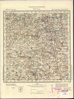
- Description:
- 1884
- Subject:
- Topical Subject: Maps, Geographic Subject: Łuków, and Topical Subject: Soviet Union
- Publisher:
- Генеральный штаб Красной Армии
- Language:
- Russian
- Date Created:
- 1940
- Identifier:
- VAC9619-002736
- Genre:
- Military Maps and Topographic Maps
- Geographic Location:
- Coordinates: 51.667, 22, 52, 22.5
- Related URL:
- Catalog URL: https://iucat.iu.edu/catalog/5020129 and Download GeoTIFF: https://drive.google.com/file/d/18zTskT-MXt6Id-RtE8KmLmcEK9fm9rFJ/view?usp=sharing
- Abstract:
- Modern area represented: Łuków, Lublin province, Poland
- Call Number:
- G7000 s100 .S7 sheet M-34-9
- City:
- Луков (Łuków)
- Copyright Holder:
- No Copyright - United States
- State/Province:
- Область государственных интересов Германии (Region of German state interests)
- Physical Description:
- Scale: 1:100,000
- Persistent URL:
- http://purl.dlib.indiana.edu/iudl/images/VAC9619/VAC9619-002736
- Provenance:
- DMA Topographic Center, Library of Congress Geography & Map Division, Army Map Service Library, OMAHA
-
- Description:
- 1884
- Subject:
- Geographic Subject: Garwolin, Topical Subject: Soviet Union, and Topical Subject: Maps
- Publisher:
- Генеральный штаб Красной Армии
- Language:
- Russian
- Date Created:
- 1940
- Identifier:
- VAC9619-002735
- Genre:
- Military Maps and Topographic Maps
- Geographic Location:
- Coordinates: 51.667, 21.5, 52, 22
- Related URL:
- Catalog URL: https://iucat.iu.edu/catalog/5020129 and Download GeoTIFF: https://drive.google.com/file/d/1Vk4qvBdMGSUWWSywvNV7pqV9F--mv7L6/view?usp=sharing
- Abstract:
- Modern area represented: Garwolin, Mazovia province, Poland
- Call Number:
- G7000 s100 .S7 sheet M-34-8
- City:
- Гарволин (Garwolin)
- Copyright Holder:
- No Copyright - United States
- State/Province:
- Область государственных интересов Германии (Region of German state interests)
- Physical Description:
- Scale: 1:100,000
- Persistent URL:
- http://purl.dlib.indiana.edu/iudl/images/VAC9619/VAC9619-002735
- Provenance:
- DMA Topographic Center, Library of Congress Geography & Map Division, Army Map Service Library, OMAHA
-
- Description:
- 1884
- Subject:
- Topical Subject: Soviet Union, Topical Subject: Maps, and Geographic Subject: Warka
- Publisher:
- Генеральный штаб Красной Армии
- Language:
- Russian
- Date Created:
- 1940
- Identifier:
- VAC9619-002733
- Genre:
- Military Maps and Topographic Maps
- Geographic Location:
- Coordinates: 51.667, 21, 52, 21.5
- Related URL:
- Download GeoTIFF: https://drive.google.com/file/d/1TnP2gB4Bp_1jV1xJygiCFbrril0IM_3m/view?usp=sharing and Catalog URL: https://iucat.iu.edu/catalog/5020129
- Abstract:
- Modern area represented: Warka, Mazovia province, Poland
- Call Number:
- G7000 s100 .S7 sheet M-34-7
- City:
- Варка (Warka)
- Copyright Holder:
- No Copyright - United States
- State/Province:
- Область государственных интересов Германии (Region of German state interests)
- Physical Description:
- Scale: 1:100,000
- Persistent URL:
- http://purl.dlib.indiana.edu/iudl/images/VAC9619/VAC9619-002733
- Provenance:
- DMA Topographic Center, Library of Congress Geography & Map Division, Army Map Service Library, OMAHA
-
- Description:
- 1885
- Subject:
- Geographic Subject: Grójec, Topical Subject: Soviet Union, and Topical Subject: Maps
- Publisher:
- Генеральный штаб Красной Армии
- Language:
- Russian
- Date Created:
- 1940
- Identifier:
- VAC9619-002731
- Genre:
- Military Maps and Topographic Maps
- Geographic Location:
- Coordinates: 51.667, 20.5, 52, 21
- Related URL:
- Catalog URL: https://iucat.iu.edu/catalog/5020129 and Download GeoTIFF: https://drive.google.com/file/d/1i_lJbq58CgA05IljNSqtprbs7tfDowEI/view?usp=sharing
- Abstract:
- Modern area represented: Grójec, Mazovia province, Poland
- Call Number:
- G7000 s100 .S7 sheet M-34-6
- City:
- Груйец (Grójec)
- Copyright Holder:
- No Copyright - United States
- State/Province:
- Область государственных интересов Германии (Region of German state interests)
- Physical Description:
- Scale: 1:100,000
- Persistent URL:
- http://purl.dlib.indiana.edu/iudl/images/VAC9619/VAC9619-002731
- Provenance:
- CIA Map Library, CIA Map Branch -- Received
-
- Description:
- 1888
- Subject:
- Geographic Subject: Skierniewice, Topical Subject: Maps, and Topical Subject: Soviet Union
- Publisher:
- Генеральный штаб Красной Армии
- Language:
- Russian
- Date Created:
- 1940
- Identifier:
- VAC9619-002728
- Genre:
- Military Maps and Topographic Maps
- Geographic Location:
- Coordinates: 51.667, 20, 52, 20.5
- Related URL:
- Download GeoTIFF: https://drive.google.com/file/d/1fwNMQzrTwEv1xJWQzr37FrX9hA6AyOVl/view?usp=sharing and Catalog URL: https://iucat.iu.edu/catalog/5020129
- Abstract:
- Modern area presented: Skierniewice, Łódź province, Poland
- Call Number:
- G7000 s100 .S7 sheet M-34-5
- City:
- Скерневицэ (Skierniewice)
- Copyright Holder:
- No Copyright - United States
- State/Province:
- Область государственных интересов Германии (Region of German state interests)
- Physical Description:
- Scale: 1:100,000
- Persistent URL:
- http://purl.dlib.indiana.edu/iudl/images/VAC9619/VAC9619-002728
- Provenance:
- DMA Topographic Center, Library of Congress Geography & Map Division, Army Map Service Library, OMAHA
