
Search Constraints
You searched for:
Publisher
Главное управление геодезии и картографии при СНК СССР
Remove constraint Publisher: Главное управление геодезии и картографии при СНК СССР
State/Province
Ленинградская область (Leningrad oblast)
Remove constraint State/Province: Ленинградская область (Leningrad oblast)
« Previous |
1 - 10 of 65
|
Next »
Search Results
-
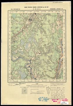
- Description:
- 1938
- Subject:
- Geographic Subject: Dvorishchi, Topical Subject: Soviet Union, and Topical Subject: Maps
- Publisher:
- Главное управление геодезии и картографии при СНК СССР
- Language:
- Russian
- Identifier:
- VAC9619-003371
- Genre:
- Military Maps and Topographic Maps
- Geographic Location:
- Coordinates: 58.5, 32.25, 58.667, 32.5
- Related URL:
- Catalog URL: http://iucat.iu.edu/catalog/5020131 and Download GeoTIFF: https://drive.google.com/file/d/1g824LzZlf3RRWsdzTBr8h7RVARtfdI_k/view?usp=sharing
- Abstract:
- Modern area represented: Дворищи (Dvorishchi), Novgorodskaya oblast, Russia
- Call Number:
- G7000 s50 .S68 sheet O-36-53-B
- Caption:
- Для служебного пользования
- City:
- Дворищи (Dvorishchi)
- Copyright Holder:
- No Copyright - United States
- Country:
- СССР (USSR)
- State/Province:
- Ленинградская область (Leningrad oblast), Маловишерский район (Malovishersky district), and Крестецкий район (Krestetsky district)
- Physical Description:
- Scale: 1:50,000
- Persistent URL:
- http://purl.dlib.indiana.edu/iudl/images/VAC9619/VAC9619-003371
- Provenance:
- M. I. Map Library
-
- Description:
- 1937
- Subject:
- Topical Subject: Soviet Union, Geographic Subject: Budogoshch, and Topical Subject: Maps
- Publisher:
- Главное управление геодезии и картографии при СНК СССР
- Language:
- Russian
- Date Created:
- 1941
- Identifier:
- VAC9619-002131
- Genre:
- Military Maps and Topographic Maps
- Geographic Location:
- Coordinates: 59, 32, 59.3333, 32.5
- Related URL:
- Download GeoTIFF: https://drive.google.com/open?id=1YSF-556lOfBtGACCO2UvI9SSrGDDkMYN and Catalog URL: https://iucat.iu.edu/catalog/5020129
- Abstract:
- Modern area represented: Budogoshch, Russia
- Call Number:
- G7000 s100 .S7 sheet O-36-29
- Caption:
- Для служебного пользования
- City:
- Будогощь (Budogoshch)
- Copyright Holder:
- No Copyright - United States
- Country:
- СССР (USSR)
- State/Province:
- Чудовский район (Chudovsky district), Ленинградская область (Leningrad oblast), РСФСР (RSFSR), Киришский район (Kirishsky district), and Маловишерский район ...
- Physical Description:
- Scale: 1:100,000
- Persistent URL:
- http://purl.dlib.indiana.edu/iudl/images/VAC9619/VAC9619-002131
- Provenance:
- Army Map Service Library, Library of Congress G & M Division
-
- Description:
- 1936
- Subject:
- Topical Subject: Soviet Union, Topical Subject: Maps, and Geographic Subject: Nebolchi
- Publisher:
- Главное управление геодезии и картографии при СНК СССР
- Language:
- Russian
- Date Created:
- 1941
- Identifier:
- VAC9619-002133
- Genre:
- Topographic Maps and Military Maps
- Geographic Location:
- Coordinates: 59, 33, 59.3333, 33.5
- Related URL:
- Catalog URL: https://iucat.iu.edu/catalog/5020129 and Download GeoTIFF: https://drive.google.com/open?id=1U5gzlSz2a1NCAv6mDxB8Jh7sfuf3e5mI
- Abstract:
- Modern area represented: Неболчи (Nebolchi), Novgorodskaya oblast, Russia
- Call Number:
- G7000 s100 .S7 sheet O-36-31
- Caption:
- Для служебного пользования
- City:
- Неболчи (Nebolchi)
- Copyright Holder:
- No Copyright - United States
- Country:
- СССР (USSR)
- State/Province:
- Ленинградская область (Leningrad oblast) and РСФСР (RSFSR)
- Physical Description:
- Scale: 1:100,000
- Persistent URL:
- http://purl.dlib.indiana.edu/iudl/images/VAC9619/VAC9619-002133
- Provenance:
- DMA Topographic Center, Army Map Service Library, Library of Congress G & M Division
-

- Description:
- 1938
- Subject:
- Topical Subject: Soviet Union, Geographic Subject: Menyusha, and Topical Subject: Maps
- Publisher:
- Главное управление геодезии и картографии при СНК СССР
- Language:
- Russian
- Date Created:
- 1940
- Identifier:
- VAC9619-002141
- Genre:
- Topographic Maps and Military Maps
- Geographic Location:
- Coordinates: 58.3333, 30.5, 58.6667, 31
- Related URL:
- Download GeoTIFF: https://drive.google.com/open?id=1rAh5vxs28ciqg8ypvRJQ83miA2yO8NTU and Catalog URL: https://iucat.iu.edu/catalog/5020129
- Abstract:
- Modern area represented: Менюша (Menyusha), Novgorodskaya oblast, Russia
- Call Number:
- G7000 s100 .S7 sheet O-36-50
- Caption:
- Captured map and Для служебного пользования
- City:
- Менюши (Menyushi)
- Copyright Holder:
- No Copyright - United States
- Country:
- СССР (USSR)
- State/Province:
- Ленинградская область (Leningrad oblast), Новгородский район (Novgorod district), РСФСР (RSFSR), Батецкий район (Batetsky district), and Шимский район (Shims...
- Physical Description:
- Scale: 1:100,000
- Persistent URL:
- http://purl.dlib.indiana.edu/iudl/images/VAC9619/VAC9619-002141
- Provenance:
- DMA Topographic Center, Army Map Service Library, Library of Congress G & M Division
-

- Description:
- 1937
- Subject:
- Geographic Subject: Lyuban, Topical Subject: Maps, and Topical Subject: Soviet Union
- Publisher:
- Главное управление геодезии и картографии при СНК СССР
- Language:
- Russian
- Date Created:
- 1941
- Identifier:
- VAC9619-000038
- Genre:
- Military Maps and Topographic Maps
- Geographic Location:
- Coordinates: 59.3333, 31.25, 59.5, 31.5
- Related URL:
- Catalog URL: http://iucat.iu.edu/catalog/5020131 and Download GeoTIFF: https://drive.google.com/open?id=1pCEJjO8p7ASUgF6_aNi1rh6126bkDjgo
- Abstract:
- Modern area represented: Lyuban, Russia
- Call Number:
- G7000 s50 .S68 sheet O-36-15-D
- Caption:
- Для служебного пользования,Captured map
- City:
- Любань (Lyuban)
- Copyright Holder:
- No Copyright - United States
- Country:
- СССР (USSR)
- State/Province:
- Ленинградская область (Leningrad oblast), Тосненский район (Tosnensky district), and РСФСР (RSFSR)
- Physical Description:
- Scale: 1:50,000
- Persistent URL:
- http://purl.dlib.indiana.edu/iudl/images/VAC9619/VAC9619-000038
- Provenance:
- DMA Topographic Center, Army Map Service Library, Library of Congress Geography & Map Division
-

- Description:
- 1938
- Subject:
- Geographic Subject: Nalyuchi, Topical Subject: Soviet Union, and Topical Subject: Maps
- Publisher:
- Главное управление геодезии и картографии при СНК СССР
- Language:
- Russian
- Date Created:
- 1940
- Identifier:
- VAC9619-003525
- Genre:
- Military Maps and Topographic Maps
- Geographic Location:
- Coordinates: 57.66667, 31.75, 57.83333, 32.0
- Related URL:
- Download GeoTIFF: https://drive.google.com/file/d/1sFselxWPujPodWUqJlqPIV8m91n3gL0P/view?usp=sharing and Catalog URL: http://iucat.iu.edu/catalog/5020131
- Abstract:
- Modern area represented: Налючи (Nalyuchi), Novgorodskaya oblast, Russia
- Call Number:
- GM G7000 s50 .S68 sheet O-36-76-D
- Caption:
- Для служебного пользования
- City:
- Налючи (Nalyuchi)
- Copyright Holder:
- No Copyright - United States
- Country:
- СССР (USSR)
- State/Province:
- Лычковский район (Lychkovsky district), Старорусский район (Starorussky district), Демянский район (Demyansky district), Ленинградская область (Leningrad obl...
- Physical Description:
- Scale: 1:50,000
- Persistent URL:
- http://purl.dlib.indiana.edu/iudl/images/VAC9619/VAC9619-003525
- Provenance:
- DMA Topographic Center, Army Map Service Library, OMAHA, Library of Congress Geography & Map Division
-
- Description:
- 1939
- Subject:
- Geographic Subject: Lyuban, Topical Subject: Maps, and Topical Subject: Soviet Union
- Publisher:
- Главное управление геодезии и картографии при СНК СССР
- Language:
- Russian
- Date Created:
- 1941
- Identifier:
- VAC9619-002124
- Genre:
- Military Maps and Topographic Maps
- Geographic Location:
- Coordinates: 59.3333, 31, 59.6667, 31.5
- Related URL:
- Download GeoTIFF: https://drive.google.com/open?id=1XoMqH9A81q94V0iQ2ZXQ0WNYxt3K5y4j and Catalog URL: https://iucat.iu.edu/catalog/5020129
- Abstract:
- Modern area represented: Lyuban, Leningrad oblast, Russia
- Call Number:
- G7000 s100 .S7 sheet O-36-15
- Caption:
- Для служебного пользования
- City:
- Любань (Lyuban)
- Copyright Holder:
- No Copyright - United States
- Country:
- СССР (USSR)
- State/Province:
- РСФСР (RSFSR) and Ленинградская область (Leningrad oblast)
- Physical Description:
- Scale: 1:100,000
- Persistent URL:
- http://purl.dlib.indiana.edu/iudl/images/VAC9619/VAC9619-002124
- Provenance:
- DMA Topographic Center, Army Map Service Library, OMAHA
-
- Description:
- 1939
- Subject:
- Topical Subject: Maps, Topical Subject: Soviet Union, and Geographic Subject: Staritsa
- Publisher:
- Главное управление геодезии и картографии при СНК СССР
- Language:
- Russian
- Date Created:
- 1941
- Identifier:
- VAC9619-002834
- Genre:
- Military Maps and Topographic Maps
- Geographic Location:
- Coordinates: 57.167, 31.75, 57.333, 32
- Related URL:
- Catalog URL: http://iucat.iu.edu/catalog/5020131 and Download GeoTIFF: https://drive.google.com/file/d/1fl4L7GVIlX3UXBuwHrA6QVyThKUkZMBU/view?usp=sharing
- Abstract:
- Modern area represented: Старица (Staritsa), Марёвский район (Marevskiy Rayon), Новгородская область (Novgorodskaya oblast), Russia
- Call Number:
- GM G7000 s50 .S68 sheet O-36-100-B
- Caption:
- Captured map
- City:
- Старица (Staritsa)
- Copyright Holder:
- No Copyright - United States
- Country:
- СССР (USSR)
- State/Province:
- Ленинградская область (Leningrad oblast) and Молвотицкий район (Molvotitsky district)
- Physical Description:
- Scale: 1:50,000
- Persistent URL:
- http://purl.dlib.indiana.edu/iudl/images/VAC9619/VAC9619-002834
- Provenance:
- Army Map Service Library, OMAHA, Library of Congress Geography & Map Division
-
- Description:
- 1939
- Subject:
- Geographic Subject: Shlisselburg, Topical Subject: Maps, and Topical Subject: Soviet Union
- Publisher:
- Главное управление геодезии и картографии при СНК СССР
- Language:
- Russian
- Identifier:
- VAC9619-002119
- Genre:
- Military Maps and Topographic Maps
- Geographic Location:
- Coordinates: 59.6667, 31, 60, 31.5
- Related URL:
- Catalog URL: https://iucat.iu.edu/catalog/5020129 and Download GeoTIFF: https://drive.google.com/open?id=1NWwV1NaoFcHIzMLhQhLljp9dZ5zYBwnX
- Abstract:
- Modern area represented: Shlisselburg, Leningrad oblast, Russia
- Call Number:
- G7000 s100 .S7 sheet O-36-3
- Caption:
- Для служебного пользования,Captured map
- City:
- Шлиссельбург (Shlisselburg)
- Copyright Holder:
- No Copyright - United States
- Country:
- СССР (USSR)
- State/Province:
- Ленинградская область (Leningrad oblast)
- Physical Description:
- Scale: 1:100,000
- Persistent URL:
- http://purl.dlib.indiana.edu/iudl/images/VAC9619/VAC9619-002119
- Provenance:
- DMA Topographic Center, Army Map Service Library, OMAHA
-
- Description:
- 1939
- Subject:
- Topical Subject: Maps, Geographic Subject: Knyazhevo, and Topical Subject: Soviet Union
- Publisher:
- Главное управление геодезии и картографии при СНК СССР
- Language:
- Russian
- Identifier:
- VAC9619-002836
- Genre:
- Topographic Maps and Military Maps
- Geographic Location:
- Coordinates: 57, 32, 57.167, 32.25
- Related URL:
- Catalog URL: http://iucat.iu.edu/catalog/5020131 and Download GeoTIFF: https://drive.google.com/file/d/17JYOw6NQgiVkkEQCZcLMCkEPuI8mWdmc/view?usp=sharing
- Abstract:
- Modern area represented: Княжево (Knyazhevo), Тверская область (Tverskaya oblast), Russia
- Call Number:
- GM G7000 s50 .S68 sheet O-36-101-C
- City:
- Княжево (Knyazhevo)
- Copyright Holder:
- No Copyright - United States
- Country:
- СССР (USSR)
- State/Province:
- Сережинский район (Serezhinsky district), Калининская область (Kalinin oblast), Пеновский район (Penovsky district), Ленинградская область (Leningrad oblast)...
- Physical Description:
- Scale: 1:50,000
- Persistent URL:
- http://purl.dlib.indiana.edu/iudl/images/VAC9619/VAC9619-002836
- Provenance:
- DMA Topographic Center, Army Map Service Library, OMAHA, Library of Congress Geography & Map Division
