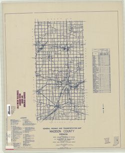
Topical Subject: Roads and Geographic Subject: Madison County (Ind.)
Creator:
Indiana. State Highway Commission (1919-1953)
Publisher:
State Highway Commission of Indiana
Date Created:
1949
Identifier:
VAC3073-M-00703
Genre:
Road maps
Geographic Location:
Coordinates: W0855200 W0853500 N0402300 N0395700
Related URL:
Catalog URL: https://iucat.iu.edu/catalog/5706658
Abstract:
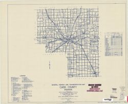
Blueline. "State roads revised to January 1, 1949." "1937." "Data obtained from State-wide Highway Planning Survey." Includes l...
Call Number:
G4093.M2 P2 1949 .I53
Caption:
Imprint: [Indianapolis?] : State Highway Commission of Indiana, 1949.
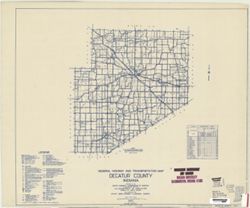
Geographic Subject: Decatur County (Ind.) and Topical Subject: Roads
Creator:
Indiana. State Highway Commission (1919-1953)
Publisher:
State Highway Commission of Indiana
Date Created:
1949
Identifier:
VAC3073-M-00697
Genre:
Road maps
Geographic Location:
Coordinates: W0854100 W0851800 N0392700 N0390800
Related URL:
Catalog URL: https://iucat.iu.edu/catalog/5704035
Abstract:
Blueline. "State roads revised to January 1, 1949." "Data obtained from Statewide Highway Planning Survey." Includes chart "Culture ...
Call Number:
G4093.D4P2 1949 .I53
Caption:
Imprint: [Indianapolis?] : State Highway Commission of Indiana. 1949.
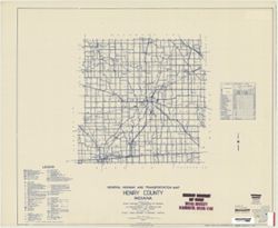
Topical Subject: Roads and Geographic Subject: Henry County (Ind.)
Creator:
Indiana. State Highway Commission (1919-1953)
Publisher:
State Highway Commission of Indiana
Date Created:
1949
Identifier:
VAC3073-M-00688
Genre:
Road maps
Geographic Location:
Coordinates: W0853600 W0852500 N0400500 N0394700
Related URL:
Catalog URL: https://iucat.iu.edu/catalog/5706069
Abstract:
Blueline. "State roads revised to January 1, 1949." "Data obtained from Statewide Highway Planning Survey." Includes chart "Culture ...
Call Number:
G4093.H6P2 1949 .I53
Caption:
Imprint: [Indianapolis?] : State Highway Commission of Indiana, 1949.
Geographic Subject: De Kalb County (Ind.) and Topical Subject: Roads
Creator:
Indiana. State Highway Commission (1919-1953)
Publisher:
Indiana. State Highway Commission (1919-1953)
Date Created:
1949
Identifier:
VAC3073-M-00643
Genre:
Road maps
Geographic Location:
Coordinates: W0851200 W0844800 N0413200 N0411600
Related URL:
Catalog URL: https://iucat.iu.edu/catalog/5361316
Abstract:
Blue line print. "State roads rev. to Jan. 1949." "Data obtained from Statewide Highway Planning Survey." Includes chart "Culture in...
Call Number:
G4093.D25 P2 1949 .I53
Caption:
Imprint: [Indianapolis?] : The Commission, [1949?]
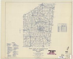
Geographic Subject: Ripley County (Ind.) and Topical Subject: Roads
Creator:
Indiana. State Highway Commission (1919-1953)
Publisher:
State Highway Commission of Indiana
Date Created:
1949
Identifier:
VAC3073-M-00601
Genre:
Road maps
Geographic Location:
Coordinates: W0852700 W0850400 N0391900 N0385500
Related URL:
Catalog URL: https://iucat.iu.edu/catalog/5824281
Abstract:
Blueline. "State road revised to January 1, 1949." "Data obtained from Statewide Highway Planning Survey." Includes chart "Culture i...
Call Number:
G4093.R5 P2 1949 .I535
Caption:
Imprint: [Indianapolis?] : State Highway Commission of Indiana, 1949.
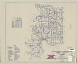
Geographic Subject: Posey County (Ind.) and Topical Subject: Roads
Creator:
Indiana. State Highway Commission (1919-1953)
Publisher:
State Highway Commission of Indiana
Date Created:
1949
Identifier:
VAC3073-M-00597
Genre:
Road maps
Geographic Location:
Coordinates: W0880600 W0874100 N0381400 N0374600
Related URL:
Catalog URL: https://iucat.iu.edu/catalog/5708369
Abstract:
Blueline. "State roads revised to January 1, 1949." "1937." "Data obtained from State-wide Highway Planning Survey." Includes l...
Call Number:
G4093.P6 P2 1949 .I53
Caption:
Imprint: [Indianapolis?] : State Highway Commission of Indiana, 1949.