Geographic Subject: Indianapolis Metropolitan Area (Ind.), Topical Subject: Schools, Topical Subject: Administrative and political divisions, Geographic Subj...
Creator:
Palmer, Thos. W. (Thomas W.) and Carpenter, H. C.
Publisher:
Baker & Randolph
Date Created:
1889
Identifier:
VAC3073-M-01274
Genre:
Maps and Cadastral maps
Geographic Location:
Coordinates: W0860929 W0860929 N0394606 N0394606
Related URL:
Catalog URL: new.iucat.iu.edu/catalog/4665173
Abstract:
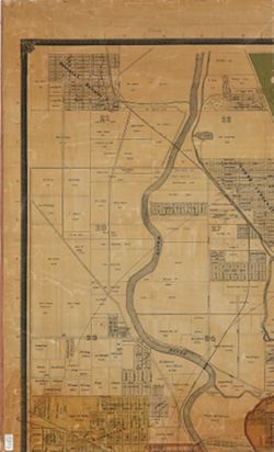
Surveyed and compiled from official records by H.C Carpenter , Thos. W. Palmer, draughtsman. Cadastral map showing landowners. Shows ward and school district...
Call Number:
G4094.I4G46 1889 .C37
Caption:
Imprint: Indianapolis : Baker & Randolph, [c1889]
Physical Description:
Scale: Approximately 1:7,150 and Dimensions: 159 x 206 cm, on sheets 89 x 57 cm or smaller
Geographic Subject: Mapleton (Indianapolis, Ind.), Geographic Subject: Indianapolis (Ind.), Topical Subject: Landowners, and Geographic Subject: Marion Count...
Creator:
Carpenter, H. C.
Publisher:
Baker & Randolph
Date Created:
1889
Identifier:
VAC3073-M-00656
Genre:
Cadastral maps
Geographic Location:
Coordinates: W0861941 W0855614 N0395538 N0393755
Related URL:
Catalog URL: https://iucat.iu.edu/catalog/4665173
Abstract:
Cadastral map showing landowners. Shows ward and school district boundaries. Originally issued in 6 sheets, mounted on linen, shellacked, and dissected in 8 ...
Call Number:
G4094.I4 G46 1889 .C37
Caption:
Imprint: Indianapolis : Baker & Randolph, [1889].
Physical Description:
Scale: 1:7,150 and Dimensions: 159 x 206 cm, on sheets 89 x 57 cm or smaller

![Map of the City of Indianapolis and its suburbs [map]](https://iiif.uits.iu.edu/iiif/2/v692v943f%2Ffiles%2Fcb6898c0-54f1-4245-b5e2-96cd8bf1b867/full/250,/0/default.jpg)