
Search Constraints
You searched for:
Date Created
1941
Remove constraint Date Created: 1941
State/Province
Ленинградская область (Leningrad oblast)
Remove constraint State/Province: Ленинградская область (Leningrad oblast)
Search Results
-
- Description:
- 1937
- Subject:
- Topical Subject: Maps, Topical Subject: Soviet Union, and Geographic Subject: Khrepelki
- Publisher:
- Главное управление государственной съемки и картографии НКВД СССР
- Language:
- Russian
- Date Created:
- 1941
- Identifier:
- VAC9619-003339
- Genre:
- Military Maps and Topographic Maps
- Geographic Location:
- Coordinates: 58.667, 30.5, 58.833, 30.75
- Related URL:
- DataCORE Dataset Download: https://datacore.iu.edu/concern/data_sets/st74cr23g
- Abstract:
- Modern area represented: Khrepelki, Leningrad oblast, Russia
- Call Number:
- G7000 s50 .S68 sheet O-36-38-C
- Caption:
- Для служебного пользования
- City:
- Хрепелки (Khrepelki)
- Copyright Holder:
- No Copyright - United States
- Country:
- СССР (USSR)
- State/Province:
- РСФСР (RSFSR), Ленинградская область (Leningrad oblast), Батецкий район (Batetsky district), and Оредежский район (Oredezhsky district)
- Physical Description:
- Scale: 1:50,000
- Persistent URL:
- http://purl.dlib.indiana.edu/iudl/images/VAC9619/VAC9619-003339
- Provenance:
- Army Map Service Library, OMAHA, Library of Congress Geography & Map Division
-
- Description:
- 1936
- Subject:
- Topical Subject: Soviet Union, Geographic Subject: Glad', and Topical Subject: Maps
- Publisher:
- Главное управление государственной съемки и картографии НКВД СССР
- Language:
- Russian
- Date Created:
- 1941
- Identifier:
- VAC9619-003327
- Genre:
- Topographic Maps and Military Maps
- Geographic Location:
- Coordinates: 59, 32, 59.167, 32.25
- Related URL:
- DataCORE Dataset Download: https://datacore.iu.edu/concern/data_sets/ng451j39d
- Abstract:
- Modern area represented: Гладь (Glad'), Novgorodskaya oblast, Russia
- Call Number:
- G7000 s50 .S68 sheet O-36-29-C
- Caption:
- Для служебного пользования and Captured map
- City:
- Гладь (Glad')
- Copyright Holder:
- No Copyright - United States
- Country:
- СССР (USSR)
- State/Province:
- РСФСР (RSFSR), Ленинградская область (Leningrad oblast), Маловишерский район (Malovishersky district), and Чудовский район (Chudovsky district)
- Physical Description:
- Scale: 1:50,000
- Persistent URL:
- http://purl.dlib.indiana.edu/iudl/images/VAC9619/VAC9619-003327
- Provenance:
- Army Map Service Library, OMAHA, Library of Congress Geography & Map Division
-
- Description:
- 1936
- Subject:
- Topical Subject: Maps, Topical Subject: Soviet Union, and Geographic Subject: Glad'
- Publisher:
- Главное управление государственной съемки и картографии НКВД СССР
- Language:
- Russian
- Date Created:
- 1941
- Identifier:
- VAC9619-003326
- Genre:
- Military Maps and Topographic Maps
- Geographic Location:
- Coordinates: 59, 32, 59.167, 32.25
- Related URL:
- DataCORE Dataset Download: https://datacore.iu.edu/concern/data_sets/gq67js087
- Abstract:
- Modern area represented: Гладь (Glad'), Novgorodskaya oblast, Russia
- Call Number:
- G7000 s50 .S68 sheet O-36-29-C
- Caption:
- Для служебного пользования
- City:
- Гладь (Glad')
- Copyright Holder:
- No Copyright - United States
- Country:
- СССР (USSR)
- State/Province:
- Чудовский район (Chudovsky district), Маловишерский район (Malovishersky district), РСФСР (RSFSR), and Ленинградская область (Leningrad oblast)
- Physical Description:
- Scale: 1:50,000
- Persistent URL:
- http://purl.dlib.indiana.edu/iudl/images/VAC9619/VAC9619-003326
- Provenance:
- M. I. Map Library
-
- Description:
- 1936
- Subject:
- Topical Subject: Soviet Union, Topical Subject: Maps, and Geographic Subject: Oskuy
- Publisher:
- Главное управление государственной съемки и картографии НКВД СССР
- Language:
- Russian
- Date Created:
- 1941
- Identifier:
- VAC9619-003323
- Genre:
- Topographic Maps and Military Maps
- Geographic Location:
- Coordinates: 59.167, 32, 59.333, 32.25
- Related URL:
- DataCORE Dataset Download: https://datacore.iu.edu/concern/data_sets/3x816n38t
- Abstract:
- Modern area represented: Oskuy, Novgorod oblast, Russia
- Call Number:
- G7000 s50 .S68 sheet O-36-29-A
- Caption:
- Для служебного пользования
- City:
- Оскуй (Oskuy)
- Copyright Holder:
- No Copyright - United States
- Country:
- СССР (USSR)
- State/Province:
- Чудовский район (Chudovsky district), РСФСР (RSFSR), Киришский район (Kirishsky district), and Ленинградская область (Leningrad oblast)
- Physical Description:
- Scale: 1:50,000
- Persistent URL:
- http://purl.dlib.indiana.edu/iudl/images/VAC9619/VAC9619-003323
- Provenance:
- DMA Topographic Center, Army Map Service Library, OMAHA, Library of Congress Geography & Map Division
-
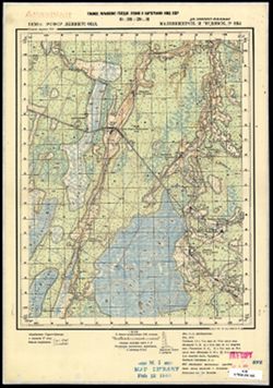
- Description:
- 1937
- Subject:
- Geographic Subject: Sosninskaya Pristan’, Topical Subject: Soviet Union, and Topical Subject: Maps
- Publisher:
- Главное управление государственной съемки и картографии НКВД СССР
- Language:
- Russian
- Date Created:
- 1941
- Identifier:
- VAC9619-003322
- Genre:
- Topographic Maps and Military Maps
- Geographic Location:
- Coordinates: 59, 31.75, 59.167, 32
- Related URL:
- DataCORE Dataset Download: https://datacore.iu.edu/concern/data_sets/8049g589s
- Abstract:
- Modern area represented: Соснинская Пристань (Sosninskaya Pristan’), Novgorodskaya oblast, Russia
- Call Number:
- G7000 s50 .S68 sheet O-36-28-D
- Caption:
- Captured map and Для служебного пользования
- City:
- Соснинская Пристань (Sosninskaya Pristan’)
- Copyright Holder:
- No Copyright - United States
- Country:
- СССР (USSR)
- State/Province:
- РСФСР (RSFSR), Ленинградская область (Leningrad oblast), Маловишерский район (Malovishersky district), and Чудовский район (Chudovsky district)
- Physical Description:
- Scale: 1:50,000
- Persistent URL:
- http://purl.dlib.indiana.edu/iudl/images/VAC9619/VAC9619-003322
- Provenance:
- DMA Topographic Center, Army Map Service Library, OMAHA, Library of Congress Geography & Map Division
-
- Description:
- 1937
- Subject:
- Topical Subject: Maps, Geographic Subject: Vditsko, and Topical Subject: Soviet Union
- Publisher:
- Главное управление государственной съемки и картографии НКВД СССР
- Language:
- Russian
- Date Created:
- 1941
- Identifier:
- VAC9619-003317
- Genre:
- Military Maps and Topographic Maps
- Geographic Location:
- Coordinates: 59, 31, 59.167, 31.25
- Related URL:
- DataCORE Dataset Download: https://datacore.iu.edu/concern/data_sets/th83m010f
- Abstract:
- Modern area represented: Вдицко (Vditsko), Novgorodskaya oblast, Russia
- Call Number:
- G7000 s50 .S68 sheet O-36-27-C
- Caption:
- Captured map and Секретно
- City:
- Вдицко (Vditsko)
- Copyright Holder:
- No Copyright - United States
- Country:
- СССР (USSR)
- State/Province:
- РСФСР (RSFSR), Тосненский район (Tosnensky district), Ленинградская область (Leningrad oblast), and Новгородский район (Novgorod district)
- Physical Description:
- Scale: 1:50,000
- Persistent URL:
- http://purl.dlib.indiana.edu/iudl/images/VAC9619/VAC9619-003317
- Provenance:
- M. I. Map Library
-
- Description:
- 1939
- Subject:
- Topical Subject: Soviet Union, Geographic Subject: ostrov Karedzhi, and Topical Subject: Maps
- Publisher:
- Главное управление геодезии и картографии при СНК СССР
- Language:
- Russian
- Date Created:
- 1941
- Identifier:
- VAC9619-002952
- Genre:
- Military Maps and Topographic Maps
- Geographic Location:
- Coordinates: 60, 31.25, 60.167, 31.5
- Related URL:
- DataCORE Dataset Download: https://datacore.iu.edu/concern/data_sets/gq67js044
- Abstract:
- Modern area represented: остров Кареджи (ostrov Karedzhi)
- Call Number:
- GM G7000 s50 .S68 sheet P-36-135-D
- Caption:
- Для служебного пользования
- City:
- остров Кареджский (ostrov Karedzhskiy)
- Copyright Holder:
- No Copyright - United States
- Country:
- СССР (USSR)
- State/Province:
- Ленинградская область (Leningrad oblast), РСФСР (RSFSR), and Мгинский район (Mginsky district)
- Physical Description:
- Scale: 1:50,000
- Persistent URL:
- http://purl.dlib.indiana.edu/iudl/images/VAC9619/VAC9619-002952
- Provenance:
- DMA Topographic Center, Army Map Service Library, OMAHA, Library of Congress Geography & Map Division
-
- Description:
- 1939
- Subject:
- Geographic Subject: Kivgoda, Topical Subject: Soviet Union, and Topical Subject: Maps
- Publisher:
- Главное управление геодезии и картографии при СНК СССР
- Language:
- Russian
- Date Created:
- 1941
- Identifier:
- VAC9619-002953
- Genre:
- Military Maps and Topographic Maps
- Geographic Location:
- Coordinates: 60.167, 31.5, 60.333, 31.75
- Related URL:
- DataCORE Dataset Download: https://datacore.iu.edu/concern/data_sets/jh343t130
- Abstract:
- Modern area represented: Kivgoda, Leningrad oblast, Russia
- Call Number:
- GM G7000 s50 .S68 sheet P-36-136-A
- Caption:
- Для служебного пользования
- City:
- Кивгода (Kivgoda)
- Copyright Holder:
- No Copyright - United States
- Country:
- СССР (USSR)
- State/Province:
- Ленинградская область (Leningrad oblast), Мгинский район (Mginsky district), РСФСР (RSFSR), and Волховский район (Volkhov district)
- Physical Description:
- Scale: 1:50,000
- Persistent URL:
- http://purl.dlib.indiana.edu/iudl/images/VAC9619/VAC9619-002953
- Provenance:
- DMA Topographic Center, Army Map Service Library, OMAHA, Library of Congress Geography & Map Division
-
- Description:
- 1939
- Subject:
- Topical Subject: Maps, Topical Subject: Soviet Union, and Geographic Subject: Kivgoda
- Publisher:
- Главное управление геодезии и картографии при СНК СССР
- Language:
- Russian
- Date Created:
- 1941
- Identifier:
- VAC9619-002954
- Genre:
- Topographic Maps and Military Maps
- Geographic Location:
- Coordinates: 60.167, 31.5, 60.333, 31.75
- Related URL:
- DataCORE Dataset Download: https://datacore.iu.edu/concern/data_sets/3f462612m
- Abstract:
- Modern area represented: Kivgoda, Leningrad oblast, Russia
- Call Number:
- GM G7000 s50 .S68 sheet P-36-136-A
- Caption:
- Для служебного пользования
- City:
- Кивгода (Kivgoda)
- Copyright Holder:
- No Copyright - United States
- Country:
- СССР (USSR)
- State/Province:
- РСФСР (RSFSR), Ленинградская область (Leningrad oblast), Мгинский район (Mginsky district), and Волховский район (Volkhov district)
- Physical Description:
- Scale: 1:50,000
- Persistent URL:
- http://purl.dlib.indiana.edu/iudl/images/VAC9619/VAC9619-002954
- Provenance:
- Army Map Service Library, OMAHA, Library of Congress Geography & Map Division
-
- Description:
- 1939
- Subject:
- Topical Subject: Soviet Union, Topical Subject: Maps, and Geographic Subject: Dubno
- Publisher:
- Главное управление геодезии и картографии при СНК СССР
- Language:
- Russian
- Date Created:
- 1941
- Identifier:
- VAC9619-002955
- Genre:
- Topographic Maps and Military Maps
- Geographic Location:
- Coordinates: 60.16667, 31.75, 60.3333, 32.0
- Related URL:
- DataCORE Dataset Download: https://datacore.iu.edu/concern/data_sets/6q182k79w
- Abstract:
- Modern area represented: Dubno, Russia
- Call Number:
- GM G7000 s50 .S68 sheet P-36-136-B
- Caption:
- Для служебного пользования
- City:
- Дубно (Dubno)
- Copyright Holder:
- No Copyright - United States
- Country:
- СССР (USSR)
- State/Province:
- Волховский район (Volkhov district), Ленинградская область (Leningrad oblast), Мгинский район (Mginsky district), and РСФСР (RSFSR)
- Physical Description:
- Scale: 1:50,000
- Persistent URL:
- http://purl.dlib.indiana.edu/iudl/images/VAC9619/VAC9619-002955
- Provenance:
- DMA Topographic Center, Army Map Service Library, OMAHA, Library of Congress Geography & Map Division
