
Search Constraints
You searched for:
Date Created
1894
Remove constraint Date Created: 1894
Subject
Topical Subject: Maps
Remove constraint Subject: Topical Subject: Maps
1 - 8 of 8
Search Results
-
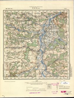
- Description:
- 1872
- Subject:
- Topical Subject: Soviet Union, Geographic Subject: Ștefănești, and Topical Subject: Maps
- Publisher:
- Генеральный штаб РККА
- Language:
- Russian
- Date Created:
- 1894
- Identifier:
- VAC9619-001501
- Genre:
- Topographic Maps and Military Maps
- Geographic Location:
- Coordinates: 47.6667, 27, 48, 27.5
- Related URL:
- DataCORE Dataset Download: https://datacore.iu.edu/concern/data_sets/9880vr72s
- Abstract:
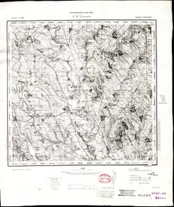
- Modern area represented: Ștefănești, Rîşcani district, Moldova
- Call Number:
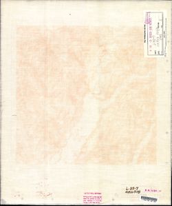
- G7000 s100 .S7 sheet L-35-7
- City:
- Стэфанештий (Ștefănești)
- Copyright Holder:
- No Copyright - United States
- Country:
- Румыния (Romania)
- State/Province:
- Бессарабия (Bessarabia)
- Physical Description:
- Scale: 1:100,000
- Persistent URL:
- http://purl.dlib.indiana.edu/iudl/images/VAC9619/VAC9619-001501
- Provenance:
- DMA Topographic Center, Army Map Service Library, OMAHA, Library of Congress Geography & Map Division, Atlasblatt
-
- Description:
- 1872
- Subject:
- Geographic Subject: Ștefănești, Topical Subject: Maps, and Topical Subject: Soviet Union
- Publisher:
- Генеральный штаб РККА
- Language:
- Russian
- Date Created:
- 1894
- Identifier:
- VAC9619-001500
- Genre:
- Military Maps and Topographic Maps
- Geographic Location:
- Coordinates: 47.6667, 27, 48, 27.5
- Related URL:
- DataCORE Dataset Download: https://datacore.iu.edu/concern/data_sets/2z10wq91c
- Abstract:
- Modern area represented: Ștefănești, Rîşcani district, Moldova
- Call Number:
- G7000 s100 .S7 sheet L-35-7
- City:
- Стэфанештий (Ștefănești)
- Copyright Holder:
- No Copyright - United States
- Country:
- Румыния (Romania)
- State/Province:
- Бессарабия (Bessarabia)
- Physical Description:
- Scale: 1:100,000
- Persistent URL:
- http://purl.dlib.indiana.edu/iudl/images/VAC9619/VAC9619-001500
- Provenance:
- Library of Congress Geography & Map Division
-
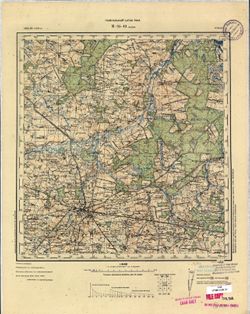
- Description:
- 1892
- Subject:
- Geographic Subject: Botoşani, Topical Subject: Soviet Union, and Topical Subject: Maps
- Publisher:
- Управление военных топографов
- Language:
- Russian
- Date Created:
- 1894
- Identifier:
- VAC9619-001494
- Genre:
- Military Maps and Topographic Maps
- Geographic Location:
- Coordinates: 47.6667, 26.5, 48, 27
- Related URL:
- DataCORE Dataset Download: https://datacore.iu.edu/concern/data_sets/zs25x929x
- Abstract:
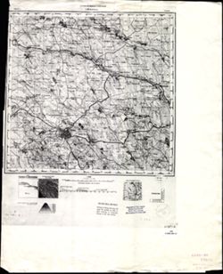
- Modern area represented: Botoşani, Botoșani county, Romania
- Call Number:
- G7000 s100 .S7 sheet L-35-6
- City:
- Ботошань (Botoşani)
- Copyright Holder:
- No Copyright - United States
- Country:
- Румыния (Romania)
- Physical Description:
- Scale: 1:100,000
- Persistent URL:
- http://purl.dlib.indiana.edu/iudl/images/VAC9619/VAC9619-001494
- Provenance:
- CIA Map Library, Army Map Service Library
-
- Description:
- 1892
- Subject:
- Geographic Subject: Raseiniai, Topical Subject: Soviet Union, and Topical Subject: Maps
- Publisher:
- Управление военных топографов РККА
- Language:
- Russian
- Date Created:
- 1894
- Identifier:
- VAC9619-003903
- Genre:
- Topographic Maps and Military Maps
- Geographic Location:
- Coordinates: 55.333, 23, 55.667, 23.5
- Related URL:
- DataCORE Dataset Download: https://datacore.iu.edu/concern/data_sets/js956g825
- Abstract:
- Modern area represented: Raseiniai, Kaunas, Lithuania
- Call Number:
- G7000 s100 .S7 sheet N-34-23
- City:
- Россиены (Raseiniai)
- Copyright Holder:
- No Copyright - United States
- Country:
- Литва (Lithuania)
- Physical Description:
- Scale: 1:100,000
- Persistent URL:
- http://purl.dlib.indiana.edu/iudl/images/VAC9619/VAC9619-003903
- Provenance:
- DMA Topographic Center, Army Map Service Library
-
- Description:
- 1873
- Subject:
- Topical Subject: Maps, Topical Subject: Soviet Union, and Geographic Subject: Kolomyia
- Publisher:
- Генеральный штаб РККА
- Language:
- Russian
- Date Created:
- 1894
- Identifier:
- VAC9619-003246
- Genre:
- Topographic Maps and Military Maps
- Geographic Location:
- Coordinates: 48.333, 25, 48.667, 25.5
- Related URL:
- DataCORE Dataset Download: https://datacore.iu.edu/concern/data_sets/rb68xc70s
- Abstract:
- Modern area represented: Kolomyia, Ivano-Frankivsk oblast, Ukraine
- Call Number:
- G7000 s100 .S7 sheet M-35-123
- City:
- Коломыя (Kolomyia)
- Copyright Holder:
- No Copyright - United States
- Country:
- Румыния (Romania) and Польша (Poland)
- Physical Description:
- Scale: 1:100,000
- Persistent URL:
- http://purl.dlib.indiana.edu/iudl/images/VAC9619/VAC9619-003246
- Provenance:
- DMA Topographic Center, Army Map Service Library, OMAHA, Geographic Names Branch
-
- Description:
- 1885
- Subject:
- Topical Subject: Maps, Geographic Subject: Solec Nad Wisłą, and Topical Subject: Soviet Union
- Publisher:
- Генеральный штаб РККА
- Language:
- Russian
- Date Created:
- 1894
- Identifier:
- VAC9619-002776
- Genre:
- Military Maps and Topographic Maps
- Geographic Location:
- Coordinates: 51, 21.5, 51.333, 22
- Related URL:
- DataCORE Dataset Download: https://datacore.iu.edu/concern/data_sets/2r36tz41w
- Abstract:
- Modern area represented: Solec Nad Wisłą, Mazovia province, Poland
- Call Number:
- G7000 s100 .S7 sheet M-34-32
- City:
- Солец (Solec)
- Copyright Holder:
- No Copyright - United States
- Country:
- Польша (Poland)
- Physical Description:
- Scale: 1:100,000
- Persistent URL:
- http://purl.dlib.indiana.edu/iudl/images/VAC9619/VAC9619-002776
- Provenance:
- CIA Map Library
-
- Description:
- 1885
- Subject:
- Topical Subject: Maps, Topical Subject: Soviet Union, and Geographic Subject: Radom
- Publisher:
- Генеральный штаб РККА
- Language:
- Russian
- Date Created:
- 1894
- Identifier:
- VAC9619-002753
- Genre:
- Topographic Maps and Military Maps
- Geographic Location:
- Coordinates: 51.333, 21, 51.667, 21.5
- Related URL:
- DataCORE Dataset Download: https://datacore.iu.edu/concern/data_sets/j38607723
- Abstract:
- Modern area represented: Radom, Mazovia province, Poland
- Call Number:
- G7000 s100 .S7 sheet M-34-19
- City:
- Радом (Radom)
- Copyright Holder:
- No Copyright - United States
- Country:
- Польша (Poland)
- Physical Description:
- Scale: 1:100,000
- Persistent URL:
- http://purl.dlib.indiana.edu/iudl/images/VAC9619/VAC9619-002753
- Provenance:
- CIA Map Library, Geogr. Seminar Stuttgart
-
- Description:
- 1891
- Subject:
- Topical Subject: Maps, Geographic Subject: Dragomireşti, and Topical Subject: Soviet Union
- Publisher:
- Генеральный штаб РККА
- Language:
- Russian
- Date Created:
- 1894
- Identifier:
- VAC9619-001748
- Genre:
- Military Maps and Topographic Maps
- Geographic Location:
- Coordinates: 46.3333, 27, 46.6667, 27.5
- Related URL:
- DataCORE Dataset Download: https://datacore.iu.edu/concern/data_sets/1n79h509d
- Abstract:
- Modern area represented: Dragomireşti, Vaslui county, Romania
- Call Number:
- G7000 s100 .S7 sheet L-35-55
- City:
- Драгомирешти (Dragomireşti)
- Copyright Holder:
- No Copyright - United States
- Country:
- Румыния (Romania)
- Physical Description:
- Scale: 1:100,000
- Persistent URL:
- http://purl.dlib.indiana.edu/iudl/images/VAC9619/VAC9619-001748
- Provenance:
- DMA Topographic Center, Army Map Service Library, OMAHA, Library of Congress Geography & Map Division
