Topical Subject: IGS Annual Reports, Geographic Subject: Clinton County (Ind.), Topical Subject: Mines and mineral resources, and Topical Subject: Geology
Creator:
Peacock, R. H., Rose, C. M. (Soil surveyor), and Tharp, W. E. (William Edgar)
Publisher:
Indiana. Department of Geology and Natural Resources
Topical Subject: IGS Annual Reports, Topical Subject: Mines and mineral resources, Topical Subject: Geology, and Geographic Subject: Howard County (Ind.)
Creator:
Rose, C. M. (Soil surveyor) and Coryell, Horace Noble, 1888-1965
Publisher:
Indiana. Department of Geology and Natural Resources
Geographic Subject: Elkhart County (Ind.), Topical Subject: Mines and mineral resources, Topical Subject: Geology, and Topical Subject: IGS Annual Reports
Creator:
Jones, Grove B., 1877- and Hesler, R. S.
Publisher:
Indiana. Department of Geology and Natural Resources
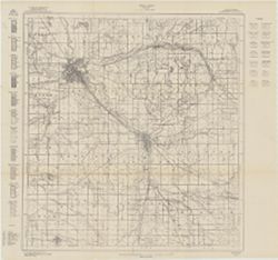
Geographic Subject: Lawrence County (Ill.), Topical Subject: Vegetation mapping, Geographic Subject: Knox County (Ind.), Geographic Subject: Gibson County (I...
Creator:
Tweedy, Frank, 1854-1937, Geological Survey (U.S.), Marshall, R. B. (Robert Bradford), 1867-1949, United States. Army. Corps of Engineers, Herron, W. H. (Wil...
Publisher:
Geological Survey (U.S.)
Date Created:
1915
Identifier:
VAC3073-M-01411
Genre:
15 minute topographic maps, Topographic maps, and Quadrangle maps
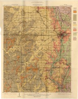
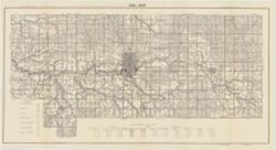
Geographic Subject: Monroe County (Ind.), Geographic Subject: Greene County (Ind.), Geographic Subject: Indiana, Geographic Subject: Owen County (Ind.), and ...
Publisher:
Indiana. Department of Geology and Natural Resources
Date Created:
1915
Identifier:
VAC3073-M-01188
Genre:
Quadrangle maps, Topographic maps, and Geological maps
Relief shown by contours and spot heights. Contour interval 20 feet. Shows limestone locations in a portion of Monroe County and small portions of Owen and G...
Call Number:
G4093.M7C5 1914 .I6
Caption:
Imprint: [Indianapolis] : Indiana Dept. of Geology [and Natural Resources], [1915] and Imprint: [Indianapolis] : [Wm. B. Burford], [1915]
Physical Description:
Scale: 1:62,500 and Dimensions: 45 x 35 cm
Alternate Identifier:
Title Control Number: a16190483 and Alternate ID: 390726IP
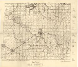
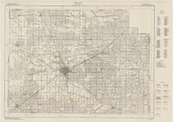
Detached from: Soil survey of Jay County / Allen David Hole. In 39th Annual report of Department of Geology and Natural Resources, Indiana. From page 54 o...
Call Number:
G4093.J4J3 1914 .H6
Caption:
Imprint: [Indianapolis] : [Department of Geology and Natural Resources, Indiana], [1915]
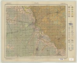
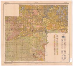
Geographic Subject: Grant County (Ind.) and Topical Subject: Soils
Creator:
Hurst, Lewis A. (Lewis Alexander), 1874-, Middleton, Philip (Soil surveyor), Hertenstein, Earl, Indiana. Department of Geology and Natural Resources, Tharp, ...
U.S. Dept. of Agriculture, Bureau of Soils [and] State of Indiana, Department of Geology , soils surveyed by Lewis A. Hurst, W.I. Watkins, and W.E. Tharp, of...
Call Number:
G4093 .G6J3 1915 .H87
Caption:
Imprint: [Washington, D.C.?] : Bureau of Soils, [1915]
Physical Description:
Scale: 1:63,360. 1 inch = 1 mile and Dimensions: 48 x 57 cm
Alternate Identifier:
Title Control Number: a16142796 and Alternate ID: CAY2874BB

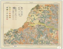
![Indiana, 15 minute series (topographic), Vincennes quadrangle. [1915 printing with vegetation]](https://iiif.uits.iu.edu/iiif/2/d791tm29s%2Ffiles%2F3ba9ccbe-8be1-48ce-9aac-c0c3b1eb0e6b/full/250,/0/default.jpg)