
Search Constraints
You searched for:
County
Contra Costa
Remove constraint County: Contra Costa
State/Province
California
Remove constraint State/Province: California
« Previous |
1 - 100 of 112
|
Next »
Search Results
-
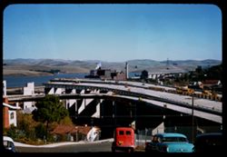
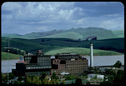
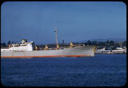
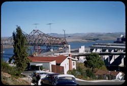
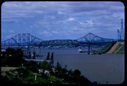
- Description:
- 50 f 8 sl
- Subject:
- Channels, Factories, Automobiles, Bridge construction, Roofs, Streets, Carquinez Strait (Calif.), Express highways, Dwellings, Hills, Smokestacks, Road const...
- Series:
- 16-57
- Creator:
- Cushman, Charles W., 1896-1972
- Date Created:
- 1957-11-14
- Genre:
- Snapshots, Views, Cityscape photographs, and Architectural photographs
- Frame Number:
- 18
- County:
- Contra Costa
- Abstract:
- New freeway unfinished
- Call Number:
- P15809
- City:
- Crockett
- Country:
- United States
- State/Province:
- California
- Alternate Identifier:
- 1657.18
- Persistent URL:
- http://purl.dlib.indiana.edu/iudl/archives/cushman/P15809
- Holding Location:
- Bloomington - University Archives
Wells Library E460
1320 E 10th St.
Bloomington, IN 47405
Contact at archives@indiana.edu, 812-855-1127
-
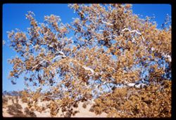
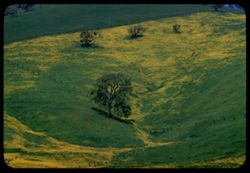
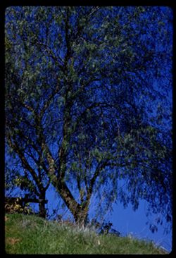
- Description:
- 50 f 6.3 sl
- Subject:
- Leaves, Tree limbs, Marsh Creek (Contra Costa County, Calif.), Hills, and Sycamores
- Series:
- 25-60
- Creator:
- Cushman, Charles W., 1896-1972
- Date Created:
- 1960-10-25
- Genre:
- Identification photographs
- Frame Number:
- 36
- County:
- Contra Costa
- Abstract:
- Top of sycamore
- Call Number:
- P11722
- Country:
- United States
- State/Province:
- California
- Alternate Identifier:
- 2560.36
- Persistent URL:
- http://purl.dlib.indiana.edu/iudl/archives/cushman/P11722
- Holding Location:
- Bloomington - University Archives
Wells Library E460
1320 E 10th St.
Bloomington, IN 47405
Contact at archives@indiana.edu, 812-855-1127
-
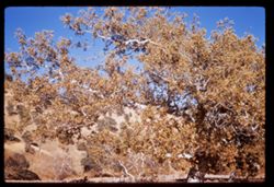
- Description:
- 50 f 6.3
- Subject:
- Marsh Creek (Contra Costa County, Calif.), Hills, Sycamores, Autumn, Trees, and Streams
- Series:
- 25-60
- Creator:
- Cushman, Charles W., 1896-1972
- Date Created:
- 1960-10-25
- Genre:
- Identification photographs
- Frame Number:
- 35
- County:
- Contra Costa
- Abstract:
- Sycamore across creek by sycamore
- Call Number:
- P11721
- Country:
- United States
- State/Province:
- California
- Alternate Identifier:
- 2560.35
- Persistent URL:
- http://purl.dlib.indiana.edu/iudl/archives/cushman/P11721
- Holding Location:
- Bloomington - University Archives
Wells Library E460
1320 E 10th St.
Bloomington, IN 47405
Contact at archives@indiana.edu, 812-855-1127
-
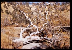
- Description:
- 50 f 8 sl
- Subject:
- Rocks, Sycamores, Trees, Marsh Creek (Contra Costa County, Calif.), Hills, and Streams
- Series:
- 25-60
- Creator:
- Cushman, Charles W., 1896-1972
- Date Created:
- 1960-10-25
- Genre:
- Identification photographs
- Frame Number:
- 34
- County:
- Contra Costa
- Abstract:
- Sycamore across creek
- Call Number:
- P11720
- Country:
- United States
- State/Province:
- California
- Alternate Identifier:
- 2560.34
- Persistent URL:
- http://purl.dlib.indiana.edu/iudl/archives/cushman/P11720
- Holding Location:
- Bloomington - University Archives
Wells Library E460
1320 E 10th St.
Bloomington, IN 47405
Contact at archives@indiana.edu, 812-855-1127
-
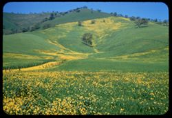
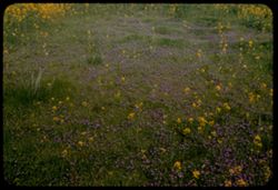
- Description:
- 50 f 9 SL
- Subject:
- Grasses, Trees, Flowers, Meadows, Fences, Hills, and Mustard (Plant)
- Series:
- 2-60
- Creator:
- Cushman, Charles W., 1896-1972
- Date Created:
- 1960-03-25
- Genre:
- Landscape photographs
- Frame Number:
- 30
- County:
- Contra Costa
- Abstract:
- Mustard & grass SE of Clayton
- Call Number:
- P10961
- City:
- Clayton
- Country:
- United States
- State/Province:
- California
- Alternate Identifier:
- 260.30
- Persistent URL:
- http://purl.dlib.indiana.edu/iudl/archives/cushman/P10961
- Holding Location:
- Bloomington - University Archives
Wells Library E460
1320 E 10th St.
Bloomington, IN 47405
Contact at archives@indiana.edu, 812-855-1127
-
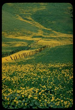
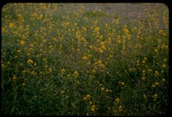
- Description:
- 100 f 8 TL
- Subject:
- Grasses, Flowers, Meadows, Fences, Hills, and Mustard (Plant)
- Series:
- 2-60
- Creator:
- Cushman, Charles W., 1896-1972
- Date Created:
- 1960-03-25
- Genre:
- Landscape photographs
- Frame Number:
- 29
- County:
- Contra Costa
- Abstract:
- Mustard & grass SE of Clayton
- Call Number:
- P10960
- City:
- Clayton
- Country:
- United States
- State/Province:
- California
- Alternate Identifier:
- 260.29
- Persistent URL:
- http://purl.dlib.indiana.edu/iudl/archives/cushman/P10960
- Holding Location:
- Bloomington - University Archives
Wells Library E460
1320 E 10th St.
Bloomington, IN 47405
Contact at archives@indiana.edu, 812-855-1127
-
- Description:
- 100 f 8 TL
- Subject:
- Diablo, Mount (Calif.), Meadows, Flowers, Hills, Mustard (Plant), Mountains, Trees, Grasses, and Fences
- Series:
- 2-60
- Creator:
- Cushman, Charles W., 1896-1972
- Date Created:
- 1960-03-25
- Genre:
- Landscape photographs
- Frame Number:
- 28
- County:
- Contra Costa
- Abstract:
- Mustard & grass SE of Clayton
- Call Number:
- P10959
- City:
- Clayton
- Country:
- United States
- State/Province:
- California
- Alternate Identifier:
- 260.28
- Persistent URL:
- http://purl.dlib.indiana.edu/iudl/archives/cushman/P10959
- Holding Location:
- Bloomington - University Archives
Wells Library E460
1320 E 10th St.
Bloomington, IN 47405
Contact at archives@indiana.edu, 812-855-1127
-
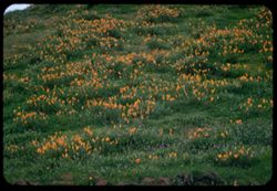
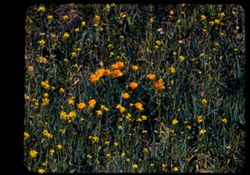
- Description:
- 100 f 4.5 TL
- Subject:
- California poppies, Alhambra Valley (Calif.), Meadows, Valleys, Hills, Grasses, and Wildflowers
- Series:
- 2-60
- Creator:
- Cushman, Charles W., 1896-1972
- Date Created:
- 1960-03-25
- Genre:
- Landscape photographs
- Frame Number:
- 27
- County:
- Contra Costa
- Abstract:
- Poppies on a green hillside Alhambra Valley
- Call Number:
- P10958
- Country:
- United States
- State/Province:
- California
- Alternate Identifier:
- 260.27
- Persistent URL:
- http://purl.dlib.indiana.edu/iudl/archives/cushman/P10958
- Holding Location:
- Bloomington - University Archives
Wells Library E460
1320 E 10th St.
Bloomington, IN 47405
Contact at archives@indiana.edu, 812-855-1127
-
- Description:
- 100 f 6.3 TL
- Subject:
- Grasses, Pepper-tree, Trees, Fences, and Hills
- Series:
- 1-60
- Creator:
- Cushman, Charles W., 1896-1972
- Date Created:
- 1960-02-16
- Genre:
- Identification photographs
- Frame Number:
- 21
- County:
- Contra Costa
- Abstract:
- Pepper tree at hill top
- Call Number:
- P10915
- City:
- Port Costa
- Country:
- United States
- State/Province:
- California
- Alternate Identifier:
- 160.21
- Persistent URL:
- http://purl.dlib.indiana.edu/iudl/archives/cushman/P10915
- Holding Location:
- Bloomington - University Archives
Wells Library E460
1320 E 10th St.
Bloomington, IN 47405
Contact at archives@indiana.edu, 812-855-1127
-
- Description:
- 100 f 5.6 tl
- Subject:
- Chimneys, Hills, Windows, Trees, Grasses, Fences, and Houses
- Series:
- 1-60
- Creator:
- Cushman, Charles W., 1896-1972
- Date Created:
- 1960-02-16
- Genre:
- Landscape photographs
- Frame Number:
- 20
- County:
- Contra Costa
- Abstract:
- Hill top at Port Costa 24,400 miles
- Call Number:
- P10914
- City:
- Port Costa
- Country:
- United States
- State/Province:
- California
- Alternate Identifier:
- 160.20
- Persistent URL:
- http://purl.dlib.indiana.edu/iudl/archives/cushman/P10914
- Holding Location:
- Bloomington - University Archives
Wells Library E460
1320 E 10th St.
Bloomington, IN 47405
Contact at archives@indiana.edu, 812-855-1127
-
- Description:
- 100 f 8 tl
- Subject:
- Trees, Diablo, Mount (Calif.), Mountains, Buildings, Clouds, and Hills
- Series:
- 1-60
- Creator:
- Cushman, Charles W., 1896-1972
- Date Created:
- 1960-01-12
- Genre:
- Landscape photographs and Cityscape photographs
- Frame Number:
- 2
- Street Address:
- Kirker Pass Road
- County:
- Contra Costa
- Abstract:
- Toward Mt D. from Kirker Pass road From hts west of Walnut Creek toward Diablo
- Call Number:
- P10896
- City:
- Walnut Creek
- Country:
- United States
- State/Province:
- California
- Alternate Identifier:
- 160.2
- Persistent URL:
- http://purl.dlib.indiana.edu/iudl/archives/cushman/P10896
- Holding Location:
- Bloomington - University Archives
Wells Library E460
1320 E 10th St.
Bloomington, IN 47405
Contact at archives@indiana.edu, 812-855-1127
-
- Description:
- 100 f 8 sl
- Subject:
- Diablo, Mount (Calif.), Hills, Mountains, Trees, Buildings, and Clouds
- Series:
- 1-60
- Creator:
- Cushman, Charles W., 1896-1972
- Date Created:
- 1960-01-12
- Genre:
- Landscape photographs and Cityscape photographs
- Frame Number:
- 1
- Street Address:
- Kirker Pass Road
- County:
- Contra Costa
- Abstract:
- Toward Mt D. from Kirker Pass road From hts west of Walnut Creek toward Diablo
- Call Number:
- P10895
- City:
- Walnut Creek
- Country:
- United States
- State/Province:
- California
- Alternate Identifier:
- 160.1
- Persistent URL:
- http://purl.dlib.indiana.edu/iudl/archives/cushman/P10895
- Holding Location:
- Bloomington - University Archives
Wells Library E460
1320 E 10th St.
Bloomington, IN 47405
Contact at archives@indiana.edu, 812-855-1127
-
- Description:
- 100 f 6.3 tl
- Subject:
- Refineries, Sugar industry, Trees, Meadows, Buildings, California and Hawaiian Sugar Company, Clouds, Hills, Smokestacks, and Carquinez Strait (Calif.)
- Series:
- 2-58
- Creator:
- Cushman, Charles W., 1896-1972
- Date Created:
- 1958-04-01
- Genre:
- Landscape photographs
- Frame Number:
- 20
- County:
- Contra Costa and Solano
- Abstract:
- Sugarmill and Solano hills beyond Carquinez Str.
- Call Number:
- P09715
- City:
- Crockett
- Country:
- United States
- State/Province:
- California
- Alternate Identifier:
- 258.20
- Persistent URL:
- http://purl.dlib.indiana.edu/iudl/archives/cushman/P09715
- Holding Location:
- Bloomington - University Archives
Wells Library E460
1320 E 10th St.
Bloomington, IN 47405
Contact at archives@indiana.edu, 812-855-1127
-
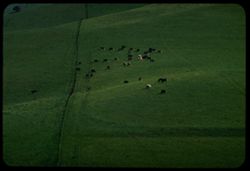
- Description:
- 100 F 8 TL
- Subject:
- Meadows, Hills, Cattle, Kirker Pass (Calif.), and Grazing
- Series:
- 1-58
- Creator:
- Cushman, Charles W., 1896-1972
- Date Created:
- 1958-02-26
- Genre:
- Landscape photographs
- Frame Number:
- 32
- County:
- Contra Costa
- Abstract:
- Cattle again
- Call Number:
- P09690
- Country:
- United States
- State/Province:
- California
- Alternate Identifier:
- 158.32
- Persistent URL:
- http://purl.dlib.indiana.edu/iudl/archives/cushman/P09690
- Holding Location:
- Bloomington - University Archives
Wells Library E460
1320 E 10th St.
Bloomington, IN 47405
Contact at archives@indiana.edu, 812-855-1127
-
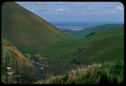
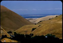
- Description:
- 100 f 8 tl
- Subject:
- Kirker Pass (Calif.), Roads, Trees, Meadows, Clouds, Passes (Landforms), Utility poles, and Hills
- Series:
- 1-58
- Creator:
- Cushman, Charles W., 1896-1972
- Date Created:
- 1958-02-26
- Genre:
- Landscape photographs
- Frame Number:
- 31
- County:
- Contra Costa
- Abstract:
- View toward delta
- Call Number:
- P09689
- Country:
- United States
- State/Province:
- California
- Alternate Identifier:
- 158.31
- Persistent URL:
- http://purl.dlib.indiana.edu/iudl/archives/cushman/P09689
- Holding Location:
- Bloomington - University Archives
Wells Library E460
1320 E 10th St.
Bloomington, IN 47405
Contact at archives@indiana.edu, 812-855-1127
-
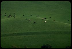
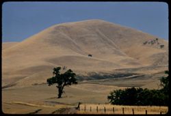
- Description:
- 100 f 6.3 tl
- Subject:
- Kirker Pass (Calif.), Grazing, Meadows, Cattle, and Hills
- Series:
- 1-58
- Creator:
- Cushman, Charles W., 1896-1972
- Date Created:
- 1958-02-20
- Genre:
- Landscape photographs
- Frame Number:
- 30
- County:
- Contra Costa
- Abstract:
- Cattle on green hillside
- Call Number:
- P09688
- Country:
- United States
- State/Province:
- California
- Alternate Identifier:
- 158.30
- Persistent URL:
- http://purl.dlib.indiana.edu/iudl/archives/cushman/P09688
- Holding Location:
- Bloomington - University Archives
Wells Library E460
1320 E 10th St.
Bloomington, IN 47405
Contact at archives@indiana.edu, 812-855-1127
-
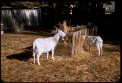
- Description:
- 50 f 5.6 sl
- Subject:
- Animal feeding, Diablo, Mount (Calif.), Livestock, Outbuildings, Hay, Farms, and Goats
- Series:
- 18-57
- Creator:
- Cushman, Charles W., 1896-1972
- Date Created:
- 1958-01-03
- Genre:
- Identification photographs
- Frame Number:
- 32
- County:
- Contra Costa
- Abstract:
- Goats at lunch
- Call Number:
- P09655
- City:
- Clayton
- Country:
- United States
- State/Province:
- California
- Alternate Identifier:
- 1857.32
- Persistent URL:
- http://purl.dlib.indiana.edu/iudl/archives/cushman/P09655
- Holding Location:
- Bloomington - University Archives
Wells Library E460
1320 E 10th St.
Bloomington, IN 47405
Contact at archives@indiana.edu, 812-855-1127
-
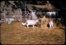
- Description:
- 50 f 6.3 sl
- Subject:
- Animal feeding, Livestock, Watering troughs, Pails, Farmhouses, Outbuildings, Chickens, Hay, Farms, Goats, and Fences
- Series:
- 18-57
- Creator:
- Cushman, Charles W., 1896-1972
- Date Created:
- 1958-01-03
- Genre:
- Identification photographs
- Frame Number:
- 31
- County:
- Contra Costa
- Abstract:
- Goats at lunch
- Call Number:
- P09654
- City:
- Clayton
- Country:
- United States
- State/Province:
- California
- Alternate Identifier:
- 1857.31
- Persistent URL:
- http://purl.dlib.indiana.edu/iudl/archives/cushman/P09654
- Holding Location:
- Bloomington - University Archives
Wells Library E460
1320 E 10th St.
Bloomington, IN 47405
Contact at archives@indiana.edu, 812-855-1127
-
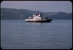
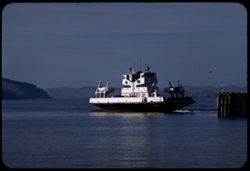
- Description:
- 100 f 5.6 tl
- Subject:
- Channels, M.V. Carquinez (Ferry), Hills, Mountains, Carquinez Strait (Calif.), and Ferries
- Series:
- 18-57
- Creator:
- Cushman, Charles W., 1896-1972
- Date Created:
- 1957-12-25
- Genre:
- Marine photographs
- Frame Number:
- 30
- County:
- Solano and Contra Costa
- Abstract:
- Ferry Carquinez approaches Martinez
- Call Number:
- P09653
- City:
- Benicia and Martinez
- Country:
- United States
- State/Province:
- California
- Alternate Identifier:
- 1857.30
- Persistent URL:
- http://purl.dlib.indiana.edu/iudl/archives/cushman/P09653
- Holding Location:
- Bloomington - University Archives
Wells Library E460
1320 E 10th St.
Bloomington, IN 47405
Contact at archives@indiana.edu, 812-855-1127
-
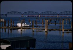
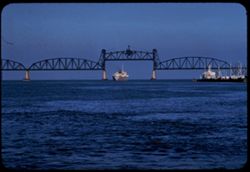
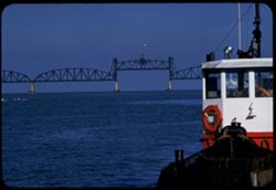
- Description:
- 100 f 8 tl
- Subject:
- Piers & wharves, Channels, Boats, Railroad bridges, Government vessels, Ships, Carquinez Strait (Calif.), Warships, Naval yards & naval stations, and...
- Series:
- 18-57
- Creator:
- Cushman, Charles W., 1896-1972
- Date Created:
- 1957-12-25
- Genre:
- Marine photographs and Architectural photographs
- Frame Number:
- 29
- County:
- Contra Costa
- Abstract:
- Moth ball fleet & SP bridge from ferry pier
- Call Number:
- P09652
- City:
- Martinez
- Country:
- United States
- State/Province:
- California
- Alternate Identifier:
- 1857.29
- Persistent URL:
- http://purl.dlib.indiana.edu/iudl/archives/cushman/P09652
- Holding Location:
- Bloomington - University Archives
Wells Library E460
1320 E 10th St.
Bloomington, IN 47405
Contact at archives@indiana.edu, 812-855-1127
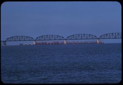
-
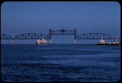
- Description:
- 100 f 8 tl
- Subject:
- Channels, Vessels, Southern Pacific Railroad Company, Ships, Railroad bridges, M.S. Lions Gate (Ship), Bays (Bodies of water), Piers & wharves, Cargo shi...
- Series:
- 18-57
- Creator:
- Cushman, Charles W., 1896-1972
- Date Created:
- 1957-12-25
- Genre:
- Marine photographs and Architectural photographs
- Frame Number:
- 28
- County:
- Contra Costa
- Abstract:
- Lions Gate goes through draw at SP bridge
- Call Number:
- P09651
- City:
- Martinez
- Country:
- United States
- State/Province:
- California
- Alternate Identifier:
- 1857.28
- Persistent URL:
- http://purl.dlib.indiana.edu/iudl/archives/cushman/P09651
- Holding Location:
- Bloomington - University Archives
Wells Library E460
1320 E 10th St.
Bloomington, IN 47405
Contact at archives@indiana.edu, 812-855-1127
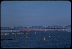
-
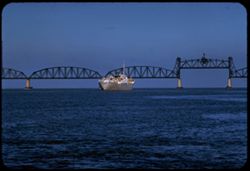
- Description:
- 100 f 8 tl
- Subject:
- Bays (Bodies of water), Piers & wharves, Vessels, M.S. Lions Gate (Ship), Railroad bridges, Suisun Bay (Calif.), Cargo ships, Ships, Carquinez Strait (Ca...
- Series:
- 18-57
- Creator:
- Cushman, Charles W., 1896-1972
- Date Created:
- 1957-12-25
- Genre:
- Marine photographs and Architectural photographs
- Frame Number:
- 27
- County:
- Contra Costa
- Abstract:
- Lions Gate and open draw
- Call Number:
- P09650
- City:
- Martinez
- Country:
- United States
- State/Province:
- California
- Alternate Identifier:
- 1857.27
- Persistent URL:
- http://purl.dlib.indiana.edu/iudl/archives/cushman/P09650
- Holding Location:
- Bloomington - University Archives
Wells Library E460
1320 E 10th St.
Bloomington, IN 47405
Contact at archives@indiana.edu, 812-855-1127
-
- Description:
- 100 f 8 tl
- Subject:
- Channels, M.S. Lions Gate (Ship), Railroad bridges, Drawbridges, Ships, Carquinez Strait (Calif.), Southern Pacific Railroad Company, and Cargo ships
- Series:
- 18-57
- Creator:
- Cushman, Charles W., 1896-1972
- Date Created:
- 1957-12-25
- Genre:
- Marine photographs and Architectural photographs
- Frame Number:
- 26
- County:
- Contra Costa
- Abstract:
- Lions Gate and open draw
- Call Number:
- P09649
- City:
- Martinez
- Country:
- United States
- State/Province:
- California
- Alternate Identifier:
- 1857.26
- Persistent URL:
- http://purl.dlib.indiana.edu/iudl/archives/cushman/P09649
- Holding Location:
- Bloomington - University Archives
Wells Library E460
1320 E 10th St.
Bloomington, IN 47405
Contact at archives@indiana.edu, 812-855-1127
-
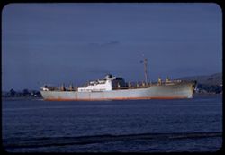
- Description:
- 100 f 8 tl
- Subject:
- Channels, M.S. Lions Gate (Ship), Cargo ships, Ships, and Carquinez Strait (Calif.)
- Series:
- 18-57
- Creator:
- Cushman, Charles W., 1896-1972
- Date Created:
- 1957-12-25
- Genre:
- Marine photographs
- Frame Number:
- 24
- County:
- Contra Costa
- Abstract:
- MS Lions Gate in Carquinez Strait Strait
- Call Number:
- P09647
- City:
- Martinez
- Country:
- United States
- State/Province:
- California
- Alternate Identifier:
- 1857.24
- Persistent URL:
- http://purl.dlib.indiana.edu/iudl/archives/cushman/P09647
- Holding Location:
- Bloomington - University Archives
Wells Library E460
1320 E 10th St.
Bloomington, IN 47405
Contact at archives@indiana.edu, 812-855-1127
-
- Description:
- 100 f 8 tl
- Subject:
- Piers & wharves, Channels, Warehouses, M.S. Lions Gate (Ship), Cargo ships, Ships, Carquinez Strait (Calif.), and Buildings
- Series:
- 18-57
- Creator:
- Cushman, Charles W., 1896-1972
- Date Created:
- 1957-12-25
- Genre:
- Marine photographs
- Frame Number:
- 25
- County:
- Contra Costa
- Abstract:
- MS Lions Gate in Carquinez Strait
- Call Number:
- P09648
- City:
- Martinez
- Country:
- United States
- State/Province:
- California
- Alternate Identifier:
- 1857.25
- Persistent URL:
- http://purl.dlib.indiana.edu/iudl/archives/cushman/P09648
- Holding Location:
- Bloomington - University Archives
Wells Library E460
1320 E 10th St.
Bloomington, IN 47405
Contact at archives@indiana.edu, 812-855-1127
-
- Description:
- 100 f 6.3 tl
- Subject:
- Piers & wharves, Channels, Tugboats, Life preservers, Railroad bridges, Defiance (Tugboat), Drawbridges, Carquinez Strait (Calif.), and Southern Pacific ...
- Series:
- 18-57
- Creator:
- Cushman, Charles W., 1896-1972
- Date Created:
- 1957-12-25
- Genre:
- Marine photographs and Architectural photographs
- Frame Number:
- 23
- County:
- Contra Costa
- Abstract:
- Tug Defiance and SPRR bridge
- Call Number:
- P09646
- City:
- Martinez
- Country:
- United States
- State/Province:
- California
- Alternate Identifier:
- 1857.23
- Persistent URL:
- http://purl.dlib.indiana.edu/iudl/archives/cushman/P09646
- Holding Location:
- Bloomington - University Archives
Wells Library E460
1320 E 10th St.
Bloomington, IN 47405
Contact at archives@indiana.edu, 812-855-1127
-
- Description:
- 100 f 6.3 tl
- Subject:
- Suisun Bay (Calif.), Warships, Government vessels, Southern Pacific Railroad Company, Ships, Railroad bridges, Bays (Bodies of water), Naval yards & nava...
- Series:
- 18-57
- Creator:
- Cushman, Charles W., 1896-1972
- Date Created:
- 1957-12-25
- Genre:
- Marine photographs and Architectural photographs
- Frame Number:
- 22
- County:
- Contra Costa
- Abstract:
- SPRR bridge & moth balled Navy fleet from ferry pier, Martinez
- Call Number:
- P09645
- City:
- Martinez
- Country:
- United States
- State/Province:
- California
- Alternate Identifier:
- 1857.22
- Persistent URL:
- http://purl.dlib.indiana.edu/iudl/archives/cushman/P09645
- Holding Location:
- Bloomington - University Archives
Wells Library E460
1320 E 10th St.
Bloomington, IN 47405
Contact at archives@indiana.edu, 812-855-1127
-
- Description:
- 100 f 8 tl
- Subject:
- Channels, Government vessels, Southern Pacific Railroad Company, Ships, Railroad bridges, Piers & wharves, Carquinez Strait (Calif.), Warships, and Naval...
- Series:
- 18-57
- Creator:
- Cushman, Charles W., 1896-1972
- Date Created:
- 1957-12-25
- Genre:
- Marine photographs and Architectural photographs
- Frame Number:
- 20
- County:
- Contra Costa
- Abstract:
- SPRR bridge & moth balled Navy fleet from ferry pier, Martinez
- Call Number:
- P09643
- City:
- Martinez
- Country:
- United States
- State/Province:
- California
- Alternate Identifier:
- 1857.20
- Persistent URL:
- http://purl.dlib.indiana.edu/iudl/archives/cushman/P09643
- Holding Location:
- Bloomington - University Archives
Wells Library E460
1320 E 10th St.
Bloomington, IN 47405
Contact at archives@indiana.edu, 812-855-1127
-
- Description:
- 100 f 6.3 tl
- Subject:
- Piers & wharves, Channels, Ferries, Carquinez Strait (Calif.), and M.V. Carquinez (Ferry)
- Series:
- 18-57
- Creator:
- Cushman, Charles W., 1896-1972
- Date Created:
- 1957-12-25
- Genre:
- Marine photographs
- Frame Number:
- 21
- County:
- Contra Costa and Solano
- Abstract:
- MV Carquinez leaving Martinez @ 3:40
- Call Number:
- P09644
- City:
- Martinez and Benicia
- Country:
- United States
- State/Province:
- California
- Alternate Identifier:
- 1857.21
- Persistent URL:
- http://purl.dlib.indiana.edu/iudl/archives/cushman/P09644
- Holding Location:
- Bloomington - University Archives
Wells Library E460
1320 E 10th St.
Bloomington, IN 47405
Contact at archives@indiana.edu, 812-855-1127
-
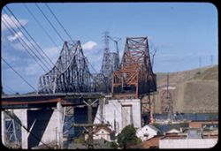
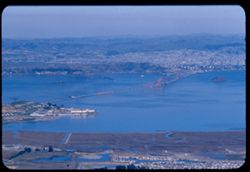
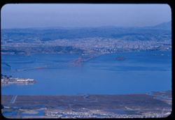
- Description:
- 100 f 6.3 tl
- Subject:
- Trestles, Channels, Electric lines, Road construction, Bridge construction, Carquinez Strait (Calif.), Express highways, Hills, Hoisting machinery, and Houses
- Series:
- 16-57
- Creator:
- Cushman, Charles W., 1896-1972
- Date Created:
- 1957-11-14
- Genre:
- Snapshots, Views, and Architectural photographs
- Frame Number:
- 26
- County:
- Contra Costa
- Abstract:
- Twin bridges Carquinez
- Call Number:
- P09591
- City:
- Crockett
- Country:
- United States
- State/Province:
- California
- Alternate Identifier:
- 1657.26
- Persistent URL:
- http://purl.dlib.indiana.edu/iudl/archives/cushman/P09591
- Holding Location:
- Bloomington - University Archives
Wells Library E460
1320 E 10th St.
Bloomington, IN 47405
Contact at archives@indiana.edu, 812-855-1127
-
- Description:
- 100 f 8 tl
- Subject:
- Channels, Hoisting machinery, Road construction, Warehouses, Bridge construction, Streets, Bridges, Trucks, Hills, Automobiles, Meadows, Carquinez Strait (Ca...
- Series:
- 16-57
- Creator:
- Cushman, Charles W., 1896-1972
- Date Created:
- 1957-11-14
- Genre:
- Landscape photographs, Snapshots, Views, and Architectural photographs
- Frame Number:
- 25
- County:
- Contra Costa and Solano
- Abstract:
- Solano county hills across Carquinez
- Call Number:
- P09590
- City:
- Crockett
- Country:
- United States
- State/Province:
- California
- Alternate Identifier:
- 1657.25
- Persistent URL:
- http://purl.dlib.indiana.edu/iudl/archives/cushman/P09590
- Holding Location:
- Bloomington - University Archives
Wells Library E460
1320 E 10th St.
Bloomington, IN 47405
Contact at archives@indiana.edu, 812-855-1127
-
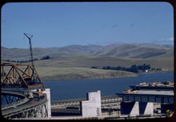
- Description:
- 100 f 4.5 tl
- Subject:
- Trestles, Channels, Carquinez Strait (Calif.), Piers & wharves, and Bridges
- Series:
- 16-57
- Creator:
- Cushman, Charles W., 1896-1972
- Date Created:
- 1957-11-14
- Genre:
- Architectural photographs
- Frame Number:
- 24
- County:
- Contra Costa
- Abstract:
- South end of new span [L]
- Call Number:
- P09589
- City:
- Crockett
- Country:
- United States
- State/Province:
- California
- Alternate Identifier:
- 1657.24
- Persistent URL:
- http://purl.dlib.indiana.edu/iudl/archives/cushman/P09589
- Holding Location:
- Bloomington - University Archives
Wells Library E460
1320 E 10th St.
Bloomington, IN 47405
Contact at archives@indiana.edu, 812-855-1127
-
- Description:
- 100 f 5.6 tl
- Subject:
- Trestles, Channels, Bridges, Piers & wharves, and Carquinez Strait (Calif.)
- Series:
- 16-57
- Creator:
- Cushman, Charles W., 1896-1972
- Date Created:
- 1957-11-14
- Genre:
- Architectural photographs
- Frame Number:
- 23
- County:
- Contra Costa
- Abstract:
- South end of new span [P]
- Call Number:
- P09588
- City:
- Crockett
- Country:
- United States
- State/Province:
- California
- Alternate Identifier:
- 1657.23
- Persistent URL:
- http://purl.dlib.indiana.edu/iudl/archives/cushman/P09588
- Holding Location:
- Bloomington - University Archives
Wells Library E460
1320 E 10th St.
Bloomington, IN 47405
Contact at archives@indiana.edu, 812-855-1127
-
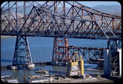
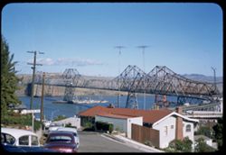
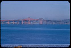
- Description:
- 50 f 8 sl
- Subject:
- Piers & wharves, Channels, Automobiles, Restaurants, Bridges, Trestles, Warehouses, and Carquinez Strait (Calif.)
- Series:
- 16-57
- Creator:
- Cushman, Charles W., 1896-1972
- Date Created:
- 1957-11-14
- Genre:
- Cityscape photographs and Architectural photographs
- Frame Number:
- 22
- County:
- Contra Costa
- Abstract:
- Carquinez bridge
- Call Number:
- P09587
- City:
- Crockett
- Country:
- United States
- State/Province:
- California
- Alternate Identifier:
- 1657.22
- Persistent URL:
- http://purl.dlib.indiana.edu/iudl/archives/cushman/P09587
- Holding Location:
- Bloomington - University Archives
Wells Library E460
1320 E 10th St.
Bloomington, IN 47405
Contact at archives@indiana.edu, 812-855-1127
-
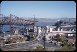
- Description:
- 50 f 6.3 sl
- Subject:
- Trestles, Channels, Factories, Automobiles, Streets, Bridges, Smokestacks, and Carquinez Strait (Calif.)
- Series:
- 16-57
- Creator:
- Cushman, Charles W., 1896-1972
- Date Created:
- 1957-11-14
- Genre:
- Cityscape photographs and Architectural photographs
- Frame Number:
- 21
- County:
- Contra Costa
- Abstract:
- Old approach & new
- Call Number:
- P09586
- City:
- Crockett
- Country:
- United States
- State/Province:
- California
- Alternate Identifier:
- 1657.21
- Persistent URL:
- http://purl.dlib.indiana.edu/iudl/archives/cushman/P09586
- Holding Location:
- Bloomington - University Archives
Wells Library E460
1320 E 10th St.
Bloomington, IN 47405
Contact at archives@indiana.edu, 812-855-1127
-
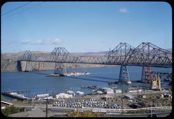
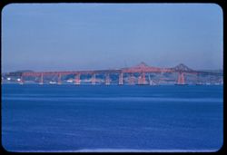
- Description:
- 50 f 8 sl
- Subject:
- Channels, Roofs, Streets, Automobiles, Bridges, Dwellings, Trestles, and Carquinez Strait (Calif.)
- Series:
- 16-57
- Creator:
- Cushman, Charles W., 1896-1972
- Date Created:
- 1957-11-14
- Genre:
- Architectural photographs and Views
- Frame Number:
- 20
- County:
- Contra Costa
- Abstract:
- Carquinez Bridges
- Call Number:
- P09585
- City:
- Crockett
- Country:
- United States
- State/Province:
- California
- Alternate Identifier:
- 1657.20
- Persistent URL:
- http://purl.dlib.indiana.edu/iudl/archives/cushman/P09585
- Holding Location:
- Bloomington - University Archives
Wells Library E460
1320 E 10th St.
Bloomington, IN 47405
Contact at archives@indiana.edu, 812-855-1127
-
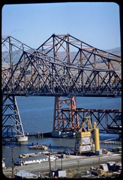
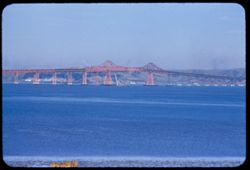
- Description:
- 50 f 8 sl
- Subject:
- Channels, Road construction, Automobiles, Bridge construction, Roofs, Streets, Carquinez Strait (Calif.), Express highways, Dwellings, Hills, and Bridges
- Series:
- 16-57
- Creator:
- Cushman, Charles W., 1896-1972
- Date Created:
- 1957-11-14
- Genre:
- Views and Architectural photographs
- Frame Number:
- 19
- County:
- Contra Costa
- Abstract:
- Unfinished concrete approaches at south end of new & old bridge
- Call Number:
- P09584
- City:
- Crockett
- Country:
- United States
- State/Province:
- California
- Alternate Identifier:
- 1657.19
- Persistent URL:
- http://purl.dlib.indiana.edu/iudl/archives/cushman/P09584
- Holding Location:
- Bloomington - University Archives
Wells Library E460
1320 E 10th St.
Bloomington, IN 47405
Contact at archives@indiana.edu, 812-855-1127
-
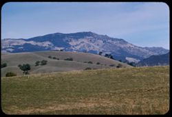
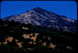
- Description:
- 100 f 6.3 tl
- Subject:
- Trees, Meadows, Mountains, Hills, and Diablo, Mount (Calif.)
- Series:
- 16-57
- Creator:
- Cushman, Charles W., 1896-1972
- Date Created:
- 1957-11-09
- Genre:
- Landscape photographs
- Frame Number:
- 13
- Street Address:
- Tassajara Road and Dougherty Road
- County:
- Contra Costa
- Abstract:
- Mount Diablo from junction with Tassajara rd.
- Call Number:
- P09579
- Country:
- United States
- State/Province:
- California
- Alternate Identifier:
- 1657.13
- Persistent URL:
- http://purl.dlib.indiana.edu/iudl/archives/cushman/P09579
- Holding Location:
- Bloomington - University Archives
Wells Library E460
1320 E 10th St.
Bloomington, IN 47405
Contact at archives@indiana.edu, 812-855-1127
-
- Description:
- 100 f 6.3 tl
- Subject:
- Barbed wire, Diablo, Mount (Calif.), Tree limbs, Mountains, Fences, Hills, and Meadows
- Series:
- 16-57
- Creator:
- Cushman, Charles W., 1896-1972
- Date Created:
- 1957-11-09
- Genre:
- Landscape photographs
- Frame Number:
- 12
- Street Address:
- Dougherty Road
- County:
- Contra Costa
- Abstract:
- Mount Diablo from south along Dougherty rd. from farther north Car mileage 200,222)
- Call Number:
- P09578
- Country:
- United States
- State/Province:
- California
- Alternate Identifier:
- 1657.12
- Persistent URL:
- http://purl.dlib.indiana.edu/iudl/archives/cushman/P09578
- Holding Location:
- Bloomington - University Archives
Wells Library E460
1320 E 10th St.
Bloomington, IN 47405
Contact at archives@indiana.edu, 812-855-1127
-
- Description:
- 100 f 6.3 tl
- Subject:
- Trees, Diablo, Mount (Calif.), Mountains, Hills, and Meadows
- Series:
- 16-57
- Creator:
- Cushman, Charles W., 1896-1972
- Date Created:
- 1957-11-09
- Genre:
- Landscape photographs
- Frame Number:
- 11
- Street Address:
- Dougherty Road
- County:
- Contra Costa
- Abstract:
- Mount Diablo from south along Dougherty rd.
- Call Number:
- P09577
- Country:
- United States
- State/Province:
- California
- Alternate Identifier:
- 1657.11
- Persistent URL:
- http://purl.dlib.indiana.edu/iudl/archives/cushman/P09577
- Holding Location:
- Bloomington - University Archives
Wells Library E460
1320 E 10th St.
Bloomington, IN 47405
Contact at archives@indiana.edu, 812-855-1127
-
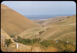
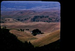
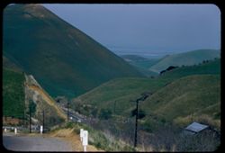
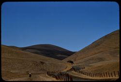
- Description:
- 100 f 8 tl
- Subject:
- Meadows, Valleys, Hills, Roads, and Kirker Pass (Calif.)
- Series:
- 16-57
- Creator:
- Cushman, Charles W., 1896-1972
- Date Created:
- 1957-10-28
- Genre:
- Landscape photographs
- Frame Number:
- 1
- County:
- Contra Costa
- Abstract:
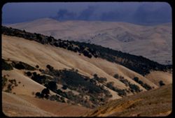
- Contra Costa hills from Kirker Pass
- Call Number:
- P09567
- Country:
- United States
- State/Province:
- California
- Alternate Identifier:
- 1657.1
- Persistent URL:
- http://purl.dlib.indiana.edu/iudl/archives/cushman/P09567
- Holding Location:
- Bloomington - University Archives
Wells Library E460
1320 E 10th St.
Bloomington, IN 47405
Contact at archives@indiana.edu, 812-855-1127
-
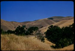
- Description:
- 100 f 8 tl
- Subject:
- Barbed wire, Trees, Meadows, Fences, and Hills
- Series:
- 10-57
- Creator:
- Cushman, Charles W., 1896-1972
- Date Created:
- 1957-06-27
- Genre:
- Landscape photographs
- Frame Number:
- 12
- Street Address:
- Kirker Pass Road
- County:
- Contra Costa
- Abstract:
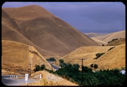
- Contra Costa dry hills - from Kirker Pass Rd.
- Call Number:
- P09386
- Country:
- United States
- State/Province:
- California
- Alternate Identifier:
- 1057.12
- Persistent URL:
- http://purl.dlib.indiana.edu/iudl/archives/cushman/P09386
- Holding Location:
- Bloomington - University Archives
Wells Library E460
1320 E 10th St.
Bloomington, IN 47405
Contact at archives@indiana.edu, 812-855-1127
-
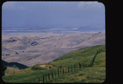
- Description:
- 100 f 8 tl
- Subject:
- Kirker Pass (Calif.), Valleys, Meadows, Plains, and Hills
- Series:
- 9-57
- Creator:
- Cushman, Charles W., 1896-1972
- Date Created:
- 1957-06-15
- Genre:
- Landscape photographs
- Frame Number:
- 2
- County:
- Contra Costa
- Abstract:
- NE from Kirker Pass
- Call Number:
- P09339
- Country:
- United States
- State/Province:
- California
- Alternate Identifier:
- 957.2
- Persistent URL:
- http://purl.dlib.indiana.edu/iudl/archives/cushman/P09339
- Holding Location:
- Bloomington - University Archives
Wells Library E460
1320 E 10th St.
Bloomington, IN 47405
Contact at archives@indiana.edu, 812-855-1127
-
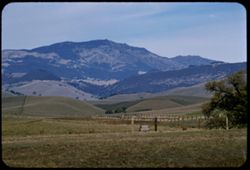
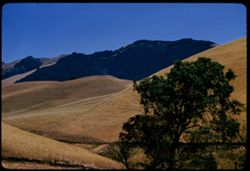
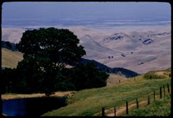
- Description:
- 100 f 6.3 tl
- Subject:
- Trees, Marsh Creek (Contra Costa County, Calif.), Mountains, Meadows, and Diablo, Mount (Calif.)
- Series:
- 9-57
- Creator:
- Cushman, Charles W., 1896-1972
- Date Created:
- 1957-06-15
- Genre:
- Landscape photographs
- Frame Number:
- 1
- County:
- Contra Costa
- Abstract:
- Top of Mt. Diablo-from Marsh Creek
- Call Number:
- P09338
- Country:
- United States
- State/Province:
- California
- Alternate Identifier:
- 957.1
- Persistent URL:
- http://purl.dlib.indiana.edu/iudl/archives/cushman/P09338
- Holding Location:
- Bloomington - University Archives
Wells Library E460
1320 E 10th St.
Bloomington, IN 47405
Contact at archives@indiana.edu, 812-855-1127
-
- Description:
- 100 f 6.3 tl
- Subject:
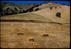
- Valleys, Farms, Diablo, Mount (Calif.), Croplands, Hills, and Meadows
- Series:
- 8-57
- Creator:
- Cushman, Charles W., 1896-1972
- Date Created:
- 1957-06-15
- Genre:
- Landscape photographs
- Frame Number:
- 21
- Street Address:
- Morgan Terrace Road
- County:
- Contra Costa
- Abstract:
- Similar-from higher
- Call Number:
- P09337
- Country:
- United States
- State/Province:
- California
- Physical Description:
- masked.
- Alternate Identifier:
- 857.21
- Persistent URL:
- http://purl.dlib.indiana.edu/iudl/archives/cushman/P09337
- Holding Location:
- Bloomington - University Archives
Wells Library E460
1320 E 10th St.
Bloomington, IN 47405
Contact at archives@indiana.edu, 812-855-1127
-
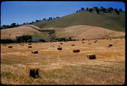
- Description:
- 100 f 6.3 tl
- Subject:
- Valleys, Farms, Barbed wire, Meadows, Croplands, Fences, Hay, Hills, Haystacks, and Diablo, Mount (Calif.)
- Series:
- 8-57
- Creator:
- Cushman, Charles W., 1896-1972
- Date Created:
- 1957-06-15
- Genre:
- Landscape photographs
- Frame Number:
- 20
- Street Address:
- Morgan Territory Road
- County:
- Contra Costa
- Abstract:
- View from east & west from Morgan Terr. Road
- Call Number:
- P09336
- Country:
- United States
- State/Province:
- California
- Alternate Identifier:
- 857.20
- Persistent URL:
- http://purl.dlib.indiana.edu/iudl/archives/cushman/P09336
- Holding Location:
- Bloomington - University Archives
Wells Library E460
1320 E 10th St.
Bloomington, IN 47405
Contact at archives@indiana.edu, 812-855-1127
-
- Description:
- 100 f 6.3
- Subject:
- Meadows, Diablo, Mount (Calif.), Hills, Grasses, and Trees
- Series:
- 8-57
- Creator:
- Cushman, Charles W., 1896-1972
- Date Created:
- 1957-06-15
- Genre:
- Landscape photographs
- Frame Number:
- 19
- Street Address:
- Morgan Territory Road
- County:
- Contra Costa
- Abstract:
- Hills along Morgan Terr. Road
- Call Number:
- P09335
- Country:
- United States
- State/Province:
- California
- Alternate Identifier:
- 857.19
- Persistent URL:
- http://purl.dlib.indiana.edu/iudl/archives/cushman/P09335
- Holding Location:
- Bloomington - University Archives
Wells Library E460
1320 E 10th St.
Bloomington, IN 47405
Contact at archives@indiana.edu, 812-855-1127
-
- Description:
- 100 f 6.3 tl
- Subject:
- Valleys, Trees, Diablo, Mount (Calif.), Hills, and Meadows
- Series:
- 8-57
- Creator:
- Cushman, Charles W., 1896-1972
- Date Created:
- 1957-06-15
- Genre:
- Landscape photographs
- Frame Number:
- 18
- County:
- Contra Costa
- Abstract:
- Contra Costa county=Searched mouth in
- Call Number:
- P09334
- Country:
- United States
- State/Province:
- California
- Alternate Identifier:
- 857.18
- Persistent URL:
- http://purl.dlib.indiana.edu/iudl/archives/cushman/P09334
- Holding Location:
- Bloomington - University Archives
Wells Library E460
1320 E 10th St.
Bloomington, IN 47405
Contact at archives@indiana.edu, 812-855-1127
-
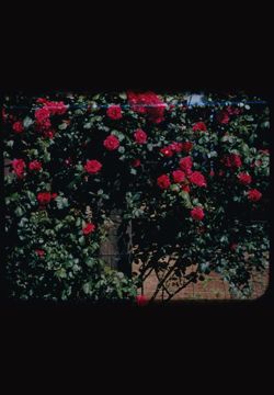
- Subject:
- Diablo, Mount (Calif.), Flowering shrubs, Flowers, Shrubs, and Roses
- Series:
- 7-57
- Creator:
- Cushman, Charles W., 1896-1972
- Date Created:
- 1957-05-31
- Genre:
- Identification photographs
- Frame Number:
- 37
- County:
- Contra Costa
- Abstract:
- Red roses
- Call Number:
- P09316
- Country:
- United States
- State/Province:
- California
- Physical Description:
- masked.
- Alternate Identifier:
- 757.37
- Persistent URL:
- http://purl.dlib.indiana.edu/iudl/archives/cushman/P09316
- Holding Location:
- Bloomington - University Archives
Wells Library E460
1320 E 10th St.
Bloomington, IN 47405
Contact at archives@indiana.edu, 812-855-1127
-
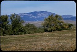
- Description:
- 100 f 8 tl
- Subject:
- Valleys, Barbed wire, Meadows, Fences, Hills, and Diablo, Mount (Calif.)
- Series:
- 7-57
- Creator:
- Cushman, Charles W., 1896-1972
- Date Created:
- 1957-05-31
- Genre:
- Landscape photographs
- Frame Number:
- 36
- County:
- Contra Costa
- Abstract:
- Toward foothills and hazy valley east of Mount Diablo
- Call Number:
- P09315
- Country:
- United States
- State/Province:
- California
- Physical Description:
- masked.
- Alternate Identifier:
- 757.36
- Persistent URL:
- http://purl.dlib.indiana.edu/iudl/archives/cushman/P09315
- Holding Location:
- Bloomington - University Archives
Wells Library E460
1320 E 10th St.
Bloomington, IN 47405
Contact at archives@indiana.edu, 812-855-1127
-
- Description:
- 100 f 8 tl ®
- Subject:
- Valleys, Barbed wire, Trees, Meadows, Plains, Fences, Hills, and Diablo, Mount (Calif.)
- Series:
- 7-57
- Creator:
- Cushman, Charles W., 1896-1972
- Date Created:
- 1957-05-31
- Genre:
- Landscape photographs
- Frame Number:
- 35
- County:
- Contra Costa
- Abstract:
- Toward foothills and hazy valley east of Mount Diablo
- Call Number:
- P09314
- Country:
- United States
- State/Province:
- California
- Alternate Identifier:
- 757.35
- Persistent URL:
- http://purl.dlib.indiana.edu/iudl/archives/cushman/P09314
- Holding Location:
- Bloomington - University Archives
Wells Library E460
1320 E 10th St.
Bloomington, IN 47405
Contact at archives@indiana.edu, 812-855-1127
-
- Description:
- 100 f 6.3 sl
- Subject:
- Croplands, Meadows, Caterpillar Tractor Company, Hills, Agricultural machinery & implements, Hay, Farms, and Tractors
- Series:
- 7-57
- Creator:
- Cushman, Charles W., 1896-1972
- Date Created:
- 1957-05-31
- Genre:
- Landscape photographs
- Frame Number:
- 34
- Street Address:
- Marsh Creek Road
- County:
- Contra Costa
- Abstract:
- More Caterpillars from Marsh Creek road
- Call Number:
- P09313
- Country:
- United States
- State/Province:
- California
- Alternate Identifier:
- 757.34
- Persistent URL:
- http://purl.dlib.indiana.edu/iudl/archives/cushman/P09313
- Holding Location:
- Bloomington - University Archives
Wells Library E460
1320 E 10th St.
Bloomington, IN 47405
Contact at archives@indiana.edu, 812-855-1127
-
- Description:
- 100 f 8 sl
- Subject:
- Agricultural machinery & implements, Pitchforks, Meadows, Croplands, Caterpillar Tractor Company, Hills, Tractors, and Hay
- Series:
- 7-57
- Creator:
- Cushman, Charles W., 1896-1972
- Date Created:
- 1957-05-31
- Genre:
- Landscape photographs
- Frame Number:
- 33
- Street Address:
- Marsh Creek Road
- County:
- Contra Costa
- Abstract:
- Big Caterpiller machine and hills of Contra Costa county along Marsh Creek road
- Call Number:
- P09312
- Country:
- United States
- State/Province:
- California
- Alternate Identifier:
- 757.33
- Persistent URL:
- http://purl.dlib.indiana.edu/iudl/archives/cushman/P09312
- Holding Location:
- Bloomington - University Archives
Wells Library E460
1320 E 10th St.
Bloomington, IN 47405
Contact at archives@indiana.edu, 812-855-1127
-
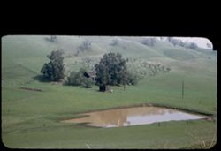
- Description:
- 100 f 6.3
- Subject:
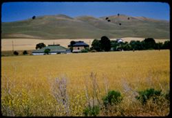
- Meadows, Hills, Farmhouses, Outbuildings, Farms, and Grasses
- Series:
- 7-57
- Creator:
- Cushman, Charles W., 1896-1972
- Date Created:
- 1957-05-31
- Genre:
- Landscape photographs and Views
- Frame Number:
- 32
- County:
- Contra Costa
- Abstract:
- Contra Costa hills & farms near Clayton
- Call Number:
- P09311
- City:
- Clayton
- Country:
- United States
- State/Province:
- California
- Alternate Identifier:
- 757.32
- Persistent URL:
- http://purl.dlib.indiana.edu/iudl/archives/cushman/P09311
- Holding Location:
- Bloomington - University Archives
Wells Library E460
1320 E 10th St.
Bloomington, IN 47405
Contact at archives@indiana.edu, 812-855-1127
-
- Description:
- 50 f 5.6
- Subject:
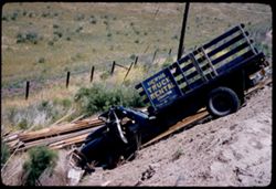
- Meadows, Trucks, Barbed wire, Lumber, Traffic accidents, Accidents, Signs (Notices), Hern's Truck Rental (Contra Costa County, Calif.), and Fences
- Series:
- 7-57
- Creator:
- Cushman, Charles W., 1896-1972
- Date Created:
- 1957-05-31
- Genre:
- Snapshots
- Frame Number:
- 31
- Street Address:
- Highway 4 and Highway 24
- County:
- Contra Costa
- Abstract:
- Truck wreck-shoulder of Hwy 4/24-Contra Costa co.
- Call Number:
- P09310
- Country:
- United States
- State/Province:
- California
- Alternate Identifier:
- 757.31
- Persistent URL:
- http://purl.dlib.indiana.edu/iudl/archives/cushman/P09310
- Holding Location:
- Bloomington - University Archives
Wells Library E460
1320 E 10th St.
Bloomington, IN 47405
Contact at archives@indiana.edu, 812-855-1127
-
- Description:
- 50 f 6.3
- Subject:
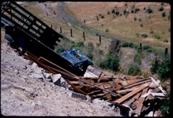
- Meadows, Trucks, Barbed wire, Lumber, Traffic accidents, Accidents, Fences, and Shrubs
- Series:
- 7-57
- Creator:
- Cushman, Charles W., 1896-1972
- Date Created:
- 1957-05-31
- Genre:
- Snapshots
- Frame Number:
- 30
- Street Address:
- Highway 4 and Highway 24
- County:
- Contra Costa
- Abstract:
- Truck wreck -shoulder of Hwy 4/24 Contra Costa co.
- Call Number:
- P09309
- Country:
- United States
- State/Province:
- California
- Alternate Identifier:
- 757.30
- Persistent URL:
- http://purl.dlib.indiana.edu/iudl/archives/cushman/P09309
- Holding Location:
- Bloomington - University Archives
Wells Library E460
1320 E 10th St.
Bloomington, IN 47405
Contact at archives@indiana.edu, 812-855-1127
-
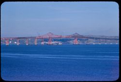
- Description:
- 100 f 8 tl
- Subject:
- Bridges, Bays (Bodies of water), Waterfronts, Utility poles, Carquinez Bridge (Calif.), and Clouds
- Series:
- 4-57
- Creator:
- Cushman, Charles W., 1896-1972
- Date Created:
- 1957-04-19
- Genre:
- Marine photographs and Architectural photographs
- Frame Number:
- 2
- County:
- Solano and Contra Costa
- Abstract:
- Carquinez Bridge
- Call Number:
- P09186
- Country:
- United States
- State/Province:
- California
- Alternate Identifier:
- 457.2
- Persistent URL:
- http://purl.dlib.indiana.edu/iudl/archives/cushman/P09186
- Holding Location:
- Bloomington - University Archives
Wells Library E460
1320 E 10th St.
Bloomington, IN 47405
Contact at archives@indiana.edu, 812-855-1127
-
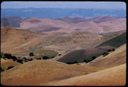
- Description:
- 100 f 8 tl
- Subject:
- Kirker Pass (Calif.), Valleys, Roads, Meadows, Mountains, Hills, and Utility poles
- Series:
- 2-57
- Creator:
- Cushman, Charles W., 1896-1972
- Date Created:
- 1957-03-27
- Genre:
- Landscape photographs
- Frame Number:
- 6
- County:
- Contra Costa
- Abstract:
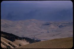
- Contra Costa Hills - view N.E. from Kirker Pass
- Call Number:
- P09132
- Country:
- United States
- State/Province:
- California
- Alternate Identifier:
- 257.6
- Persistent URL:
- http://purl.dlib.indiana.edu/iudl/archives/cushman/P09132
- Holding Location:
- Bloomington - University Archives
Wells Library E460
1320 E 10th St.
Bloomington, IN 47405
Contact at archives@indiana.edu, 812-855-1127
-
- Description:
- 100 f 4 tl
- Subject:
- Prunus, Alhambra Valley (Calif.), Trees, Flowers, and Flowering trees
- Series:
- 1-57
- Creator:
- Cushman, Charles W., 1896-1972
- Date Created:
- 1957-03-07
- Genre:
- Identification photographs
- Frame Number:
- 9
- Street Address:
- Alhambra Valley Road
- County:
- Contra Costa
- Abstract:
- Flowering Prunus along Alhambra Valley Rd.
- Call Number:
- P09115
- Country:
- United States
- State/Province:
- California
- Alternate Identifier:
- 157.9
- Persistent URL:
- http://purl.dlib.indiana.edu/iudl/archives/cushman/P09115
- Holding Location:
- Bloomington - University Archives
Wells Library E460
1320 E 10th St.
Bloomington, IN 47405
Contact at archives@indiana.edu, 812-855-1127
-
- Description:
- 50 f 6.3 sl
- Subject:
- Prunus, Alhambra Valley (Calif.), Trees, Flowers, and Flowering trees
- Series:
- 1-57
- Creator:
- Cushman, Charles W., 1896-1972
- Date Created:
- 1957-03-07
- Genre:
- Identification photographs
- Frame Number:
- 8
- Street Address:
- Alhambra Valley Road
- County:
- Contra Costa
- Abstract:
- Flowering Prunus along Alhambra Valley Rd.
- Call Number:
- P09114
- Country:
- United States
- State/Province:
- California
- Alternate Identifier:
- 157.8
- Persistent URL:
- http://purl.dlib.indiana.edu/iudl/archives/cushman/P09114
- Holding Location:
- Bloomington - University Archives
Wells Library E460
1320 E 10th St.
Bloomington, IN 47405
Contact at archives@indiana.edu, 812-855-1127
-
- Description:
- 50 f 6.3
- Subject:
- Wildflowers, Flowers, Meadows, Trestle Park, and Mustard (Plant)
- Series:
- 1-57
- Creator:
- Cushman, Charles W., 1896-1972
- Date Created:
- 1957-03-07
- Genre:
- Identification photographs
- Frame Number:
- 7
- County:
- Contra Costa
- Abstract:
- Trestle Park
- Call Number:
- P09113
- Country:
- United States
- State/Province:
- California
- Alternate Identifier:
- 157.7
- Persistent URL:
- http://purl.dlib.indiana.edu/iudl/archives/cushman/P09113
- Holding Location:
- Bloomington - University Archives
Wells Library E460
1320 E 10th St.
Bloomington, IN 47405
Contact at archives@indiana.edu, 812-855-1127
-
- Description:
- 50 f 5.6 sl
- Subject:
- Farmhouses, Outbuildings, Farms, Meadows, Croplands, Lakes & ponds, and Hills
- Series:
- 1-57
- Creator:
- Cushman, Charles W., 1896-1972
- Date Created:
- 1957-03-07
- Genre:
- Landscape photographs
- Frame Number:
- 5
- Street Address:
- Reliez Valley Road
- County:
- Contra Costa
- Abstract:
- Farm in Contra Costa county along Reliez Val. Rd.
- Call Number:
- P09111
- Country:
- United States
- State/Province:
- California
- Physical Description:
- masked.
- Alternate Identifier:
- 157.5
- Persistent URL:
- http://purl.dlib.indiana.edu/iudl/archives/cushman/P09111
- Holding Location:
- Bloomington - University Archives
Wells Library E460
1320 E 10th St.
Bloomington, IN 47405
Contact at archives@indiana.edu, 812-855-1127
-
- Description:
- 50 f 6.3
- Subject:
- Wildflowers, Flowers, Meadows, Trestle Park, and Mustard (Plant)
- Series:
- 1-57
- Creator:
- Cushman, Charles W., 1896-1972
- Date Created:
- 1957-03-07
- Genre:
- Identification photographs
- Frame Number:
- 6
- County:
- Contra Costa
- Abstract:
- Mustard and Trestle Park
- Call Number:
- P09112
- Country:
- United States
- State/Province:
- California
- Alternate Identifier:
- 157.6
- Persistent URL:
- http://purl.dlib.indiana.edu/iudl/archives/cushman/P09112
- Holding Location:
- Bloomington - University Archives
Wells Library E460
1320 E 10th St.
Bloomington, IN 47405
Contact at archives@indiana.edu, 812-855-1127
-
- Description:
- 100 f 6.3 tl
- Subject:
- Horseback riding, Diablo, Mount (Calif.), Meadows, Valleys, Hills, Barbed wire, Roads, and Fences
- Series:
- 14-56
- Creator:
- Cushman, Charles W., 1896-1972
- Date Created:
- 1956-11-13
- Genre:
- Landscape photographs
- Frame Number:
- 28
- Street Address:
- Beck Road
- County:
- Contra Costa
- Abstract:
- View north up Beck road on overcast day Contra Costa county
- Call Number:
- P09025
- Country:
- United States
- State/Province:
- California
- Alternate Identifier:
- 1456.28
- Persistent URL:
- http://purl.dlib.indiana.edu/iudl/archives/cushman/P09025
- Holding Location:
- Bloomington - University Archives
Wells Library E460
1320 E 10th St.
Bloomington, IN 47405
Contact at archives@indiana.edu, 812-855-1127
-
- Description:
- 100 f 6.3 tl
- Subject:
- Valleys, Grasses, Barbed wire, Diablo, Mount (Calif.), Fences, Shrubs, Hills, and Meadows
- Series:
- 14-56
- Creator:
- Cushman, Charles W., 1896-1972
- Date Created:
- 1956-11-13
- Genre:
- Landscape photographs
- Frame Number:
- 27
- Street Address:
- Beck Road
- County:
- Contra Costa
- Abstract:
- Views E.ward from Beck road in Contra Costa county
- Call Number:
- P09024
- Country:
- United States
- State/Province:
- California
- Alternate Identifier:
- 1456.27
- Persistent URL:
- http://purl.dlib.indiana.edu/iudl/archives/cushman/P09024
- Holding Location:
- Bloomington - University Archives
Wells Library E460
1320 E 10th St.
Bloomington, IN 47405
Contact at archives@indiana.edu, 812-855-1127
-
- Description:
- 100 f 5.6 tl
- Subject:
- Grasses, Meadows, Shrubs, Hills, and Diablo, Mount (Calif.)
- Series:
- 14-56
- Creator:
- Cushman, Charles W., 1896-1972
- Date Created:
- 1956-11-13
- Genre:
- Landscape photographs
- Frame Number:
- 26
- Street Address:
- Beck Road
- County:
- Contra Costa
- Abstract:
- Views E.ward from Beck road in Contra Costa county
- Call Number:
- P09023
- Country:
- United States
- State/Province:
- California
- Alternate Identifier:
- 1456.26
- Persistent URL:
- http://purl.dlib.indiana.edu/iudl/archives/cushman/P09023
- Holding Location:
- Bloomington - University Archives
Wells Library E460
1320 E 10th St.
Bloomington, IN 47405
Contact at archives@indiana.edu, 812-855-1127
-
- Description:
- 100 f 6.3 tl
- Subject:
- Diablo, Mount (Calif.), San Francisco Bay (Calif.), Bays (Bodies of water), Tamalpais, Mount (Calif.), Rocks, Coastlines, Clouds, Mists, and Mountains
- Series:
- 14-56
- Creator:
- Cushman, Charles W., 1896-1972
- Date Created:
- 1956-11-07
- Genre:
- Landscape photographs
- Frame Number:
- 25
- County:
- Marin and Contra Costa
- Abstract:
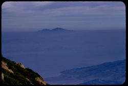
- Mt. Diablo from Tamalpais
- Call Number:
- P09022
- Country:
- United States
- State/Province:
- California
- Alternate Identifier:
- 1456.25
- Persistent URL:
- http://purl.dlib.indiana.edu/iudl/archives/cushman/P09022
- Holding Location:
- Bloomington - University Archives
Wells Library E460
1320 E 10th St.
Bloomington, IN 47405
Contact at archives@indiana.edu, 812-855-1127
-
- Description:
- 100 f 8 tl
- Subject:
- Hills, Roads, Utility poles, and Trees
- Series:
- 8-56
- Creator:
- Cushman, Charles W., 1896-1972
- Date Created:
- 1956-06-29
- Genre:
- Landscape photographs
- Frame Number:
- 11
- Street Address:
- Kirker Pass Road
- County:
- Contra Costa
- Abstract:
- View NE down Kirker Pass road toward Pittsburg- Contra Costa co. very hot
- Call Number:
- P08795
- City:
- Pittsburg
- Country:
- United States
- State/Province:
- California
- Alternate Identifier:
- 856.11
- Persistent URL:
- http://purl.dlib.indiana.edu/iudl/archives/cushman/P08795
- Holding Location:
- Bloomington - University Archives
Wells Library E460
1320 E 10th St.
Bloomington, IN 47405
Contact at archives@indiana.edu, 812-855-1127
-
- Description:
- 100 f 8 tl
- Subject:
- Trees, Smoke, Diablo, Mount (Calif.), Fences, Hills, and Meadows
- Series:
- 8-56
- Creator:
- Cushman, Charles W., 1896-1972
- Date Created:
- 1956-06-29
- Genre:
- Landscape photographs
- Frame Number:
- 10
- Street Address:
- Pine Hollow Road
- County:
- Contra Costa
- Abstract:
- Contra Costa hills north of Mt Diablo from Pine Hollow rd nr. Clayton
- Call Number:
- P08794
- City:
- Clayton
- Country:
- United States
- State/Province:
- California
- Alternate Identifier:
- 856.10
- Persistent URL:
- http://purl.dlib.indiana.edu/iudl/archives/cushman/P08794
- Holding Location:
- Bloomington - University Archives
Wells Library E460
1320 E 10th St.
Bloomington, IN 47405
Contact at archives@indiana.edu, 812-855-1127
-
- Description:
- 100 f 5.6 sl
- Subject:
- Diablo, Mount (Calif.), Hills, Mountains, Trees, Fences, and North Peak (Contra Costa County, Calif.)
- Series:
- 3-56
- Creator:
- Cushman, Charles W., 1896-1972
- Date Created:
- 1956-04-02
- Genre:
- Landscape photographs
- Frame Number:
- 38
- County:
- Contra Costa
- Abstract:
- North PK from NE
- Call Number:
- P08639
- Country:
- United States
- State/Province:
- California
- Alternate Identifier:
- 356.38
- Persistent URL:
- http://purl.dlib.indiana.edu/iudl/archives/cushman/P08639
- Holding Location:
- Bloomington - University Archives
Wells Library E460
1320 E 10th St.
Bloomington, IN 47405
Contact at archives@indiana.edu, 812-855-1127
-
- Description:
- 100 f 6.3 tl
- Subject:
- Diablo, Mount (Calif.), Hills, Orchards, Mountains, Utility poles, Trees, Farms, and Clouds
- Series:
- 3-56
- Creator:
- Cushman, Charles W., 1896-1972
- Date Created:
- 1956-04-02
- Genre:
- Landscape photographs
- Frame Number:
- 37
- County:
- Contra Costa
- Abstract:
- Mt Diablo from east
- Call Number:
- P08638
- Country:
- United States
- State/Province:
- California
- Alternate Identifier:
- 356.37
- Persistent URL:
- http://purl.dlib.indiana.edu/iudl/archives/cushman/P08638
- Holding Location:
- Bloomington - University Archives
Wells Library E460
1320 E 10th St.
Bloomington, IN 47405
Contact at archives@indiana.edu, 812-855-1127
-
- Description:
- 200 f 5.6 tl
- Subject:
- Poppies, Flowers, and Plants
- Series:
- 3-56
- Creator:
- Cushman, Charles W., 1896-1972
- Date Created:
- 1956-03-28
- Genre:
- Identification photographs
- Frame Number:
- 2
- Street Address:
- Norris Canyon Road
- County:
- Contra Costa
- Abstract:
- Poppies and mustanrd along Norris Cougars road in Contra Costa county
- Call Number:
- P08604
- Country:
- United States
- State/Province:
- California
- Alternate Identifier:
- 356.2
- Persistent URL:
- http://purl.dlib.indiana.edu/iudl/archives/cushman/P08604
- Holding Location:
- Bloomington - University Archives
Wells Library E460
1320 E 10th St.
Bloomington, IN 47405
Contact at archives@indiana.edu, 812-855-1127
-
- Description:
- 100 f 8 tl
- Subject:
- Poppies, Flowers, Mustard (Plant), and Plants
- Series:
- 3-56
- Creator:
- Cushman, Charles W., 1896-1972
- Date Created:
- 1956-03-28
- Genre:
- Identification photographs
- Frame Number:
- 1
- Street Address:
- Norris Canyon Road
- County:
- Contra Costa
- Abstract:
- Poppies and mustard along Norris Canyon road in Contra Costa county
- Call Number:
- P08603
- Country:
- United States
- State/Province:
- California
- Physical Description:
- masked.
- Alternate Identifier:
- 356.1
- Persistent URL:
- http://purl.dlib.indiana.edu/iudl/archives/cushman/P08603
- Holding Location:
- Bloomington - University Archives
Wells Library E460
1320 E 10th St.
Bloomington, IN 47405
Contact at archives@indiana.edu, 812-855-1127
-
- Description:
- 100 f 8 tl
- Subject:
- Bays (Bodies of water), Richmond-San Rafael Bridge, Cities & towns, Bridges, Tamalpais, Mount (Calif.), Hills, and Canals
- Series:
- 2-56
- Creator:
- Cushman, Charles W., 1896-1972
- Date Created:
- 1956-03-14
- Genre:
- Landscape photographs and Cityscape photographs
- Frame Number:
- 18
- County:
- Marin and Contra Costa
- Abstract:
- San Rafael - Richm'd Bridge
- Call Number:
- P08584
- City:
- San Quentin, Richmond, and San Rafael
- Country:
- United States
- State/Province:
- California
- Alternate Identifier:
- 256.18
- Persistent URL:
- http://purl.dlib.indiana.edu/iudl/archives/cushman/P08584
- Holding Location:
- Bloomington - University Archives
Wells Library E460
1320 E 10th St.
Bloomington, IN 47405
Contact at archives@indiana.edu, 812-855-1127
-
- Description:
- 100 f 8 tl
- Subject:
- Bays (Bodies of water), Richmond-San Rafael Bridge, Mountains, Bridges, Tamalpais, Mount (Calif.), Hills, Canals, and Cities & towns
- Series:
- 2-56
- Creator:
- Cushman, Charles W., 1896-1972
- Date Created:
- 1956-03-14
- Genre:
- Cityscape photographs
- Frame Number:
- 14
- County:
- Marin and Contra Costa
- Abstract:
- New San Rafael - Richmond Bridge from east point
- Call Number:
- P08580
- City:
- Richmond and San Rafael
- Country:
- United States
- State/Province:
- California
- Alternate Identifier:
- 256.14
- Persistent URL:
- http://purl.dlib.indiana.edu/iudl/archives/cushman/P08580
- Holding Location:
- Bloomington - University Archives
Wells Library E460
1320 E 10th St.
Bloomington, IN 47405
Contact at archives@indiana.edu, 812-855-1127
-
- Description:
- 100 f 8 tl
- Subject:
- Richmond-San Rafael Bridge, Girders, Bridge construction, Hills, San Francisco Bay (Calif.), Bridges, and Bays (Bodies of water)
- Series:
- 1-56
- Creator:
- Cushman, Charles W., 1896-1972
- Date Created:
- 1956-03-07
- Genre:
- Seascapes
- Frame Number:
- 37
- County:
- Marin and Contra Costa
- Abstract:
- Center span of new bridge from road near navy depot
- Call Number:
- P08566
- City:
- San Rafael and Richmond
- Country:
- United States
- State/Province:
- California
- Alternate Identifier:
- 156.37
- Persistent URL:
- http://purl.dlib.indiana.edu/iudl/archives/cushman/P08566
- Holding Location:
- Bloomington - University Archives
Wells Library E460
1320 E 10th St.
Bloomington, IN 47405
Contact at archives@indiana.edu, 812-855-1127
-
- Description:
- 100 f 6.3 tl
- Subject:
- Bays (Bodies of water), Girders, Richmond-San Rafael Bridge, Bridge construction, Bridges, Hills, and San Francisco Bay (Calif.)
- Series:
- 1-56
- Creator:
- Cushman, Charles W., 1896-1972
- Date Created:
- 1956-03-07
- Genre:
- Seascapes
- Frame Number:
- 36
- County:
- Marin and Contra Costa
- Abstract:
- Final day for new San Rafael-Richmond bridge - center span placed
- Call Number:
- P08565
- City:
- San Quentin, Richmond, and San Rafael
- Country:
- United States
- State/Province:
- California
- Alternate Identifier:
- 156.36
- Persistent URL:
- http://purl.dlib.indiana.edu/iudl/archives/cushman/P08565
- Holding Location:
- Bloomington - University Archives
Wells Library E460
1320 E 10th St.
Bloomington, IN 47405
Contact at archives@indiana.edu, 812-855-1127
-
- Description:
- 100 f 8 tl
- Subject:
- Bays (Bodies of water), Girders, Richmond-San Rafael Bridge, Bridge construction, Bridges, Hills, and San Francisco Bay (Calif.)
- Series:
- 1-56
- Creator:
- Cushman, Charles W., 1896-1972
- Date Created:
- 1956-03-07
- Genre:
- Seascapes
- Frame Number:
- 35
- County:
- Marin and Contra Costa
- Abstract:
- Final day for new San Rafael-Richmond bridge - center span placed
- Call Number:
- P08564
- City:
- Richmond and San Rafael
- Country:
- United States
- State/Province:
- California
- Alternate Identifier:
- 156.35
- Persistent URL:
- http://purl.dlib.indiana.edu/iudl/archives/cushman/P08564
- Holding Location:
- Bloomington - University Archives
Wells Library E460
1320 E 10th St.
Bloomington, IN 47405
Contact at archives@indiana.edu, 812-855-1127
-
- Description:
- 100 f 6.3 tl
- Subject:
- Bays (Bodies of water), Girders, Richmond-San Rafael Bridge, Bridge construction, Bridges, Hills, and San Francisco Bay (Calif.)
- Series:
- 1-56
- Creator:
- Cushman, Charles W., 1896-1972
- Date Created:
- 1956-03-07
- Genre:
- Seascapes
- Frame Number:
- 34
- County:
- Marin and Contra Costa
- Abstract:
- Final day for new San Rafael-Richmond bridge - center span placed
- Call Number:
- P08563
- City:
- San Quentin, Richmond, and San Rafael
- Country:
- United States
- State/Province:
- California
- Alternate Identifier:
- 156.34
- Persistent URL:
- http://purl.dlib.indiana.edu/iudl/archives/cushman/P08563
- Holding Location:
- Bloomington - University Archives
Wells Library E460
1320 E 10th St.
Bloomington, IN 47405
Contact at archives@indiana.edu, 812-855-1127
-
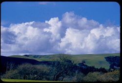
- Description:
- tl
- Subject:
- Trees, Clouds, Hills, and Las Trampas Ridge (Calif.)
- Series:
- 1-56
- Creator:
- Cushman, Charles W., 1896-1972
- Date Created:
- 1956-02-23
- Genre:
- Landscape photographs
- Frame Number:
- 17
- Street Address:
- Norris Canyon Road
- County:
- Contra Costa
- Abstract:
- Clouds to north
- Call Number:
- P08546
- Country:
- United States
- State/Province:
- California
- Alternate Identifier:
- 156.17
- Persistent URL:
- http://purl.dlib.indiana.edu/iudl/archives/cushman/P08546
- Holding Location:
- Bloomington - University Archives
Wells Library E460
1320 E 10th St.
Bloomington, IN 47405
Contact at archives@indiana.edu, 812-855-1127
-
- Description:
- tl
- Subject:
- Hills, Las Trampas Ridge (Calif.), Trees, and Clouds
- Series:
- 1-56
- Creator:
- Cushman, Charles W., 1896-1972
- Date Created:
- 1956-02-23
- Genre:
- Landscape photographs
- Frame Number:
- 16
- Street Address:
- Norris Canyon Road
- County:
- Contra Costa
- Abstract:
- Clouds to north
- Call Number:
- P08545
- Country:
- United States
- State/Province:
- California
- Alternate Identifier:
- 156.16
- Persistent URL:
- http://purl.dlib.indiana.edu/iudl/archives/cushman/P08545
- Holding Location:
- Bloomington - University Archives
Wells Library E460
1320 E 10th St.
Bloomington, IN 47405
Contact at archives@indiana.edu, 812-855-1127
-
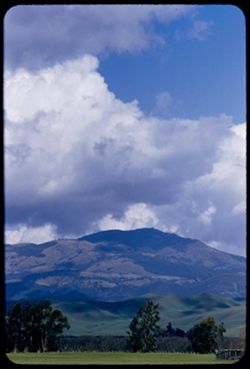
- Description:
- 50 mm lens
- Subject:
- Trees, Meadows, Mountains, Clouds, Hills, and Diablo, Mount (Calif.)
- Series:
- 1-56
- Creator:
- Cushman, Charles W., 1896-1972
- Date Created:
- 1956-02-23
- Genre:
- Landscape photographs
- Frame Number:
- 15
- Street Address:
- Norris Canyon Road
- County:
- Contra Costa
- Abstract:
- Mt. Diablo [P]
- Call Number:
- P08544
- Country:
- United States
- State/Province:
- California
- Alternate Identifier:
- 156.15
- Persistent URL:
- http://purl.dlib.indiana.edu/iudl/archives/cushman/P08544
- Holding Location:
- Bloomington - University Archives
Wells Library E460
1320 E 10th St.
Bloomington, IN 47405
Contact at archives@indiana.edu, 812-855-1127
-
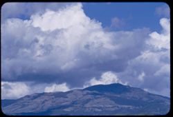
- Description:
- tl
- Subject:
- Diablo, Mount (Calif.), Mountains, and Clouds
- Series:
- 1-56
- Creator:
- Cushman, Charles W., 1896-1972
- Date Created:
- 1956-02-23
- Genre:
- Landscape photographs
- Frame Number:
- 14
- County:
- Contra Costa
- Abstract:
- Mt. Diablo
- Call Number:
- P08543
- Country:
- United States
- State/Province:
- California
- Alternate Identifier:
- 156.14
- Persistent URL:
- http://purl.dlib.indiana.edu/iudl/archives/cushman/P08543
- Holding Location:
- Bloomington - University Archives
Wells Library E460
1320 E 10th St.
Bloomington, IN 47405
Contact at archives@indiana.edu, 812-855-1127
-
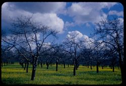
- Description:
- 1/100
- Subject:
- Flowers, Dandelions, Trees, Clouds, and Grasses
- Series:
- 1-56
- Creator:
- Cushman, Charles W., 1896-1972
- Date Created:
- 1956-02-23
- Genre:
- Landscape photographs
- Frame Number:
- 13
- Street Address:
- Norris Canyon Road
- County:
- Contra Costa
- Abstract:
- Leafless walnut grove, new dandelions in grass - & clouds
- Call Number:
- P08542
- Country:
- United States
- State/Province:
- California
- Alternate Identifier:
- 156.13
- Persistent URL:
- http://purl.dlib.indiana.edu/iudl/archives/cushman/P08542
- Holding Location:
- Bloomington - University Archives
Wells Library E460
1320 E 10th St.
Bloomington, IN 47405
Contact at archives@indiana.edu, 812-855-1127
-
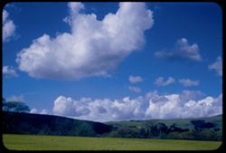
- Description:
- 50 mm 1/100
- Subject:
- Trees, Meadows, Clouds, Hills, and Las Trampas Ridge (Calif.)
- Series:
- 1-56
- Creator:
- Cushman, Charles W., 1896-1972
- Date Created:
- 1956-02-23
- Genre:
- Landscape photographs
- Frame Number:
- 12
- Street Address:
- Norris Canyon Road
- County:
- Contra Costa
- Abstract:
- Clouds northwest
- Call Number:
- P08541
- Country:
- United States
- State/Province:
- California
- Alternate Identifier:
- 156.12
- Persistent URL:
- http://purl.dlib.indiana.edu/iudl/archives/cushman/P08541
- Holding Location:
- Bloomington - University Archives
Wells Library E460
1320 E 10th St.
Bloomington, IN 47405
Contact at archives@indiana.edu, 812-855-1127
-
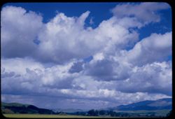
- Description:
- 50 mm 1/100
- Subject:
- Trees, Meadows, Clouds, and Hills
- Series:
- 1-56
- Creator:
- Cushman, Charles W., 1896-1972
- Date Created:
- 1956-02-23
- Genre:
- Landscape photographs
- Frame Number:
- 11
- Street Address:
- Norris Canyon Road
- County:
- Contra Costa
- Abstract:
- Clouds northeast at Norris Canyon road
- Call Number:
- P08540
- City:
- San Ramon
- Country:
- United States
- State/Province:
- California
- Alternate Identifier:
- 156.11
- Persistent URL:
- http://purl.dlib.indiana.edu/iudl/archives/cushman/P08540
- Holding Location:
- Bloomington - University Archives
Wells Library E460
1320 E 10th St.
Bloomington, IN 47405
Contact at archives@indiana.edu, 812-855-1127
-
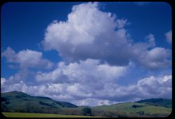
- Description:
- 50 mm 1/100
- Subject:
- Trees, Meadows, Las Trampas Ridge (Calif.), Hills, and Clouds
- Series:
- 1-56
- Creator:
- Cushman, Charles W., 1896-1972
- Date Created:
- 1956-02-23
- Genre:
- Landscape photographs
- Frame Number:
- 10
- Street Address:
- California State Highway 21 and Norris Canyon Road
- County:
- Contra Costa
- Abstract:
- Big white clouds in northwest above green hills of Las Trampas ridge
- Call Number:
- P08539
- Country:
- United States
- State/Province:
- California
- Alternate Identifier:
- 156.10
- Persistent URL:
- http://purl.dlib.indiana.edu/iudl/archives/cushman/P08539
- Holding Location:
- Bloomington - University Archives
Wells Library E460
1320 E 10th St.
Bloomington, IN 47405
Contact at archives@indiana.edu, 812-855-1127
-

- Description:
- 50 mm 1/100
- Subject:
- Roads, Trees, Diablo, Mount (Calif.), Mountains, Clouds, Hills, Utility poles, and Meadows
- Series:
- 1-56
- Creator:
- Cushman, Charles W., 1896-1972
- Date Created:
- 1956-02-23
- Genre:
- Landscape photographs
- Frame Number:
- 9
- Street Address:
- Norris Canyon Road
- County:
- Contra Costa
- Abstract:
- Mt. Diablo
- Call Number:
- P08538
- Country:
- United States
- State/Province:
- California
- Alternate Identifier:
- 156.9
- Persistent URL:
- http://purl.dlib.indiana.edu/iudl/archives/cushman/P08538
- Holding Location:
- Bloomington - University Archives
Wells Library E460
1320 E 10th St.
Bloomington, IN 47405
Contact at archives@indiana.edu, 812-855-1127
-
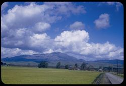
- Description:
- 50 mm 1/100 short lens
- Subject:
- Meadows, Diablo, Mount (Calif.), Hills, Mountains, Trees, Utility poles, Roads, and Clouds
- Series:
- 1-56
- Creator:
- Cushman, Charles W., 1896-1972
- Date Created:
- 1956-02-23
- Genre:
- Landscape photographs
- Frame Number:
- 8
- Street Address:
- Norris Canyon Road
- County:
- Contra Costa
- Abstract:
- Mt. Diablo
- Call Number:
- P08537
- Country:
- United States
- State/Province:
- California
- Alternate Identifier:
- 156.8
- Persistent URL:
- http://purl.dlib.indiana.edu/iudl/archives/cushman/P08537
- Holding Location:
- Bloomington - University Archives
Wells Library E460
1320 E 10th St.
Bloomington, IN 47405
Contact at archives@indiana.edu, 812-855-1127
-
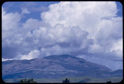
- Description:
- 100 f ? tl tele lens
- Subject:
- Diablo, Mount (Calif.), Mountains, Clouds, and Hills
- Series:
- 1-56
- Creator:
- Cushman, Charles W., 1896-1972
- Date Created:
- 1956-02-23
- Genre:
- Landscape photographs
- Frame Number:
- 7
- Street Address:
- Norris Canyon Road
- County:
- Contra Costa
- Abstract:
- Mt. Diablo
- Call Number:
- P08536
- Country:
- United States
- State/Province:
- California
- Alternate Identifier:
- 156.7
- Persistent URL:
- http://purl.dlib.indiana.edu/iudl/archives/cushman/P08536
- Holding Location:
- Bloomington - University Archives
Wells Library E460
1320 E 10th St.
Bloomington, IN 47405
Contact at archives@indiana.edu, 812-855-1127
-
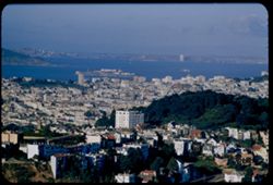
- Description:
- 200 f 5.6 tl
- Subject:
- Buildings, Islands, Cities & towns, Twin Peaks (San Francisco County, Calif.), Trees, Bays (Bodies of water), Coastlines, Houses, Alcatraz Island (Calif....
- Series:
- 29-55
- Creator:
- Cushman, Charles W., 1896-1972
- Date Created:
- 1955-12-01
- Genre:
- Cityscape photographs
- Frame Number:
- 29
- Street Address:
- Buena Vista
- County:
- Contra Costa and San Francisco
- Abstract:
- Toward Alcatraz from Twin Peaks
- Call Number:
- P08520
- City:
- San Francisco and Richmond
- Country:
- United States
- State/Province:
- California
- Alternate Identifier:
- 2955.29
- Persistent URL:
- http://purl.dlib.indiana.edu/iudl/archives/cushman/P08520
- Holding Location:
- Bloomington - University Archives
Wells Library E460
1320 E 10th St.
Bloomington, IN 47405
Contact at archives@indiana.edu, 812-855-1127
-
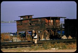
- Description:
- 100 f 5.6 tl
- Subject:
- Men, Grasses, Stilt houses, San Joaquin River (Calif.), Boats, Boulders, Stairways, Railroad tracks, Porches, Rivers, Flowers, and Waterfronts
- Series:
- 29-55
- Creator:
- Cushman, Charles W., 1896-1972
- Date Created:
- 1955-11-29
- Genre:
- Architectural photographs
- Frame Number:
- 26
- County:
- Contra Costa
- Abstract:
- San Joaquin waterfront at Antioch
- Call Number:
- P08517
- City:
- Antioch
- Country:
- United States
- State/Province:
- California
- Alternate Identifier:
- 2955.26
- Persistent URL:
- http://purl.dlib.indiana.edu/iudl/archives/cushman/P08517
- Holding Location:
- Bloomington - University Archives
Wells Library E460
1320 E 10th St.
Bloomington, IN 47405
Contact at archives@indiana.edu, 812-855-1127
-
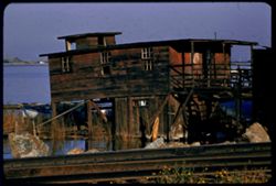
- Description:
- 100 f 6.3 tl
- Subject:
- Grasses, Stilt houses, San Joaquin River (Calif.), Boats, Boulders, Stairways, Waterfronts, Flat roofs, Rivers, Railroad tracks, and Porches
- Series:
- 29-55
- Creator:
- Cushman, Charles W., 1896-1972
- Date Created:
- 1955-11-29
- Genre:
- Architectural photographs
- Frame Number:
- 25
- County:
- Contra Costa
- Abstract:
- San Joaquin waterfront at Antioch
- Call Number:
- P08516
- City:
- Antioch
- Country:
- United States
- State/Province:
- California
- Alternate Identifier:
- 2955.25
- Persistent URL:
- http://purl.dlib.indiana.edu/iudl/archives/cushman/P08516
- Holding Location:
- Bloomington - University Archives
Wells Library E460
1320 E 10th St.
Bloomington, IN 47405
Contact at archives@indiana.edu, 812-855-1127
-
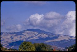
- Description:
- 100 f 8 tl
- Subject:
- Trees, Diablo, Mount (Calif.), Mountains, and Clouds
- Series:
- 29-55
- Creator:
- Cushman, Charles W., 1896-1972
- Date Created:
- 1955-11-17
- Genre:
- Landscape photographs
- Frame Number:
- 24
- County:
- Contra Costa
- Abstract:
- Mount Diablo from Danville
- Call Number:
- P08515
- City:
- Danville
- Country:
- United States
- State/Province:
- California
- Alternate Identifier:
- 2955.24
- Persistent URL:
- http://purl.dlib.indiana.edu/iudl/archives/cushman/P08515
- Holding Location:
- Bloomington - University Archives
Wells Library E460
1320 E 10th St.
Bloomington, IN 47405
Contact at archives@indiana.edu, 812-855-1127
-
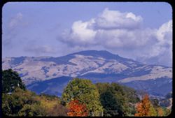
- Description:
- 100 f 6.3
- Subject:
- Trees, Diablo, Mount (Calif.), Mountains, and Clouds
- Series:
- 29-55
- Creator:
- Cushman, Charles W., 1896-1972
- Date Created:
- 1955-11-17
- Genre:
- Landscape photographs
- Frame Number:
- 23
- County:
- Contra Costa
- Abstract:
- Mount Diablo from Danville
- Call Number:
- P08514
- City:
- Danville
- Country:
- United States
- State/Province:
- California
- Alternate Identifier:
- 2955.23
- Persistent URL:
- http://purl.dlib.indiana.edu/iudl/archives/cushman/P08514
- Holding Location:
- Bloomington - University Archives
Wells Library E460
1320 E 10th St.
Bloomington, IN 47405
Contact at archives@indiana.edu, 812-855-1127
-
- Description:
- 50 f 8
- Subject:
- Men, Spouses, Sunflowers, Weeds, and Trees
- Series:
- 7-54
- Creator:
- Cushman, Charles W., 1896-1972
- Date Created:
- 1954-08-23
- Genre:
- Identification photographs
- Frame Number:
- 38
- County:
- Contra Costa
- Persons Pictured:
- Cushman, Charles W. (Charles Weever), 1896-1972
- Abstract:
- Great sunflower near San Ramon, Contra Costa county.
- Call Number:
- P07293
- City:
- San Ramon
- Country:
- United States
- State/Province:
- California
- Alternate Identifier:
- 754.38
- Persistent URL:
- http://purl.dlib.indiana.edu/iudl/archives/cushman/P07293
- Holding Location:
- Bloomington - University Archives
Wells Library E460
1320 E 10th St.
Bloomington, IN 47405
Contact at archives@indiana.edu, 812-855-1127
-
- Description:
- 50 f 8
- Subject:
- Spouses, Women, Sunflowers, Trees, Tires, and Weeds
- Series:
- 7-54
- Creator:
- Cushman, Charles W., 1896-1972
- Date Created:
- 1954-08-23
- Genre:
- Portraits and Identification photographs
- Frame Number:
- 37
- County:
- Contra Costa
- Persons Pictured:
- Cushman, Jean
- Abstract:
- Great sunflower near San Ramon, Contra Costa county.
- Call Number:
- P07292
- City:
- San Ramon
- Country:
- United States
- State/Province:
- California
- Alternate Identifier:
- 754.37
- Persistent URL:
- http://purl.dlib.indiana.edu/iudl/archives/cushman/P07292
- Holding Location:
- Bloomington - University Archives
Wells Library E460
1320 E 10th St.
Bloomington, IN 47405
Contact at archives@indiana.edu, 812-855-1127
-
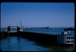
- Description:
- 100 f 5.6
- Subject:
- Construction equipment, Piers & wharves, Vessels, Hoisting machinery, Bridge construction, Ferries, Russian River (Ferry), Marine terminals, and Bodies o...
- Series:
- 2-54
- Creator:
- Cushman, Charles W., 1896-1972
- Date Created:
- 1954-05-21
- Genre:
- Marine photographs
- Frame Number:
- 10
- County:
- Marin and Contra Costa
- Abstract:
- Aboard Ferry Boat Russian River from San Rafael to Richmond Nearing Richmond slip
- Call Number:
- P07140
- City:
- Richmond and San Rafael
- Country:
- United States
- State/Province:
- California
- Alternate Identifier:
- 254.10
- Persistent URL:
- http://purl.dlib.indiana.edu/iudl/archives/cushman/P07140
- Holding Location:
- Bloomington - University Archives
Wells Library E460
1320 E 10th St.
Bloomington, IN 47405
Contact at archives@indiana.edu, 812-855-1127
-
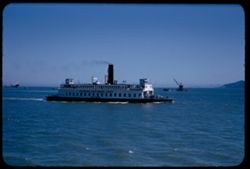
- Description:
- 100 f 5.6
- Subject:
- Bays (Bodies of water), Vessels, Bodies of water, Automobiles, Bridge construction, Signs (Notices), El Paso (Ferry), Ferries, Hills, Russian River (Ferry), ...
- Series:
- 2-54
- Creator:
- Cushman, Charles W., 1896-1972
- Date Created:
- 1954-05-21
- Genre:
- Marine photographs
- Frame Number:
- 9
- County:
- Marin and Contra Costa
- Abstract:
- Aboard Ferry Boat Russian River from San Rafael to Richmond Ferry boat Klamath [sic] - starboard
- Call Number:
- P07139
- City:
- Richmond and San Rafael
- Country:
- United States
- State/Province:
- California
- Alternate Identifier:
- 254.9
- Persistent URL:
- http://purl.dlib.indiana.edu/iudl/archives/cushman/P07139
- Holding Location:
- Bloomington - University Archives
Wells Library E460
1320 E 10th St.
Bloomington, IN 47405
Contact at archives@indiana.edu, 812-855-1127
-
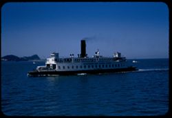
- Description:
- 125 f 5.6
- Subject:
- Bays (Bodies of water), Bodies of water, Boats, Signs (Notices), Ferries, Vehicles, Klamath (Ferry), Russian River (Ferry), Smokestacks, San Francisco Bay (C...
- Series:
- 2-54
- Creator:
- Cushman, Charles W., 1896-1972
- Date Created:
- 1954-05-21
- Genre:
- Marine photographs
- Frame Number:
- 8
- County:
- Marin and Contra Costa
- Abstract:
- Aboard Ferry Boat Russian River from San Rafael to Richmond W bound ferry on port side
- Call Number:
- P07138
- City:
- Richmond and San Rafael
- Country:
- United States
- State/Province:
- California
- Alternate Identifier:
- 254.8
- Persistent URL:
- http://purl.dlib.indiana.edu/iudl/archives/cushman/P07138
- Holding Location:
- Bloomington - University Archives
Wells Library E460
1320 E 10th St.
Bloomington, IN 47405
Contact at archives@indiana.edu, 812-855-1127