
Search Constraints
Search Results
-
- Subject:
- Topical Subject: Soviet Union, Geographic Subject: Lipitsy, and Topical Subject: Maps
- Publisher:
- Генеральный штаб Красной Армии
- Language:
- Russian
- Date Created:
- 1941
- Identifier:
- VAC9619-003149
- Genre:
- Military Maps and Topographic Maps
- Geographic Location:
- Coordinates: 53.333, 37, 53.667, 37.5
- Related URL:
- Catalog URL: https://iucat.iu.edu/catalog/5020129 and Download GeoTIFF: https://drive.google.com/file/d/1DEJf3klsNOB3iIRfqpOPFMpm2cBBmWTF/view?usp=sharing
- Abstract:
- Modern area represented: Lipitsy, Tula oblast, Russia
- Call Number:
- G7000 s100 .S7 sheet N-37-87
- City:
- Липицы (Lipitsy)
- Copyright Holder:
- No Copyright - United States
- Country:
- СССР (USSR)
- State/Province:
- Тульская область (Tula oblast) and РСФСР (RSFSR)
- Physical Description:
- Scale: 1:100,000
- Persistent URL:
- http://purl.dlib.indiana.edu/iudl/images/VAC9619/VAC9619-003149
- Provenance:
- Army Map Service Library, Library of Congress G & M Division
-
- Description:
- 1939
- Subject:
- Topical Subject: Maps, Topical Subject: Soviet Union, and Geographic Subject: Teploye
- Publisher:
- Генеральный штаб Красной Армии
- Language:
- Russian
- Date Created:
- 1941
- Identifier:
- VAC9619-003150
- Genre:
- Military Maps and Topographic Maps
- Geographic Location:
- Coordinates: 53.333, 37.5, 53.667, 38
- Related URL:
- Catalog URL: https://iucat.iu.edu/catalog/5020129 and Download GeoTIFF: https://drive.google.com/file/d/1ivANOZEaijHvqsqAV8XBniqwrZ_5PJjh/view?usp=sharing
- Abstract:
- Modern area represented: Teploye, Russia
- Call Number:
- G7000 s100 .S7 sheet N-37-88
- City:
- Теплое (Teploye)
- Copyright Holder:
- No Copyright - United States
- Country:
- СССР (USSR)
- State/Province:
- РСФСР (RSFSR) and Тульская область (Tula oblast)
- Physical Description:
- Scale: 1:100,000
- Persistent URL:
- http://purl.dlib.indiana.edu/iudl/images/VAC9619/VAC9619-003150
- Provenance:
- Army Map Service Library, Library of Congress G & M Division
-
- Subject:
- Geographic Subject: Malevka, Topical Subject: Maps, and Topical Subject: Soviet Union
- Publisher:
- Генеральный штаб Красной Армии
- Language:
- Russian
- Date Created:
- 1941
- Identifier:
- VAC9619-003151
- Genre:
- Topographic Maps and Military Maps
- Geographic Location:
- Coordinates: 53.333, 38, 53.667, 38.5
- Related URL:
- Download GeoTIFF: https://drive.google.com/file/d/1602_vkYJjL8QTbNfrlVL_Mx8kWFgJj0n/view?usp=sharing and Catalog URL: https://iucat.iu.edu/catalog/5020129
- Abstract:
- Modern area represented: Malevka, Tula oblast, Russia
- Call Number:
- G7000 s100 .S7 sheet N-37-89
- City:
- Малевка (Malevka)
- Copyright Holder:
- No Copyright - United States
- Country:
- СССР (USSR)
- State/Province:
- Тульская область (Tula oblast) and РСФСР (RSFSR)
- Physical Description:
- Scale: 1:100,000
- Persistent URL:
- http://purl.dlib.indiana.edu/iudl/images/VAC9619/VAC9619-003151
- Provenance:
- DMA Topographic Center, Army Map Service Library, Geographic Names Branch
-
- Subject:
- Topical Subject: Soviet Union, Geographic Subject: Chernava, and Topical Subject: Maps
- Publisher:
- Генеральный штаб Красной Армии
- Language:
- Russian
- Date Created:
- 1941
- Identifier:
- VAC9619-003153
- Genre:
- Military Maps and Topographic Maps
- Geographic Location:
- Coordinates: 53.333, 39, 53.667, 39.5
- Related URL:
- Catalog URL: https://iucat.iu.edu/catalog/5020129 and Download GeoTIFF: https://drive.google.com/file/d/1QNxBcZk8CQwKnsyw_o-EnjLO5_KxuP57/view?usp=sharing
- Abstract:
- Modern area represented: Chernava, Russia
- Call Number:
- G7000 s100 .S7 sheet N-37-91
- City:
- Чернава (Chernava)
- Copyright Holder:
- No Copyright - United States
- Country:
- СССР (USSR)
- State/Province:
- РСФСР (RSFSR) and Рязанская область (Ryazan oblast)
- Physical Description:
- Scale: 1:100,000
- Persistent URL:
- http://purl.dlib.indiana.edu/iudl/images/VAC9619/VAC9619-003153
- Provenance:
- DMA Topographic Center, Army Map Service Library
-
- Description:
- 1939
- Subject:
- Topical Subject: Soviet Union, Geographic Subject: Bolshoye Podovechye, and Topical Subject: Maps
- Publisher:
- Генеральный штаб Красной Армии
- Language:
- Russian
- Date Created:
- 1941
- Identifier:
- VAC9619-003154
- Genre:
- Topographic Maps and Military Maps
- Geographic Location:
- Coordinates: 53.333, 39.5, 53.667, 40
- Related URL:
- Download GeoTIFF: https://drive.google.com/file/d/16S3lBK6-jKemCv-8Nhc88_kKigOZhaKc/view?usp=sharing and Catalog URL: https://iucat.iu.edu/catalog/5020129
- Abstract:
- Modern area represented: Bolshoye Podovechye, Ryazan oblast, Russia
- Call Number:
- G7000 s100 .S7 sheet N-37-92
- City:
- Большое Подовечье (Bolshoye Podovechye)
- Copyright Holder:
- No Copyright - United States
- Country:
- СССР (USSR)
- State/Province:
- РСФСР (RSFSR) and Рязанская область (Ryazan oblast)
- Physical Description:
- Scale: 1:100,000
- Persistent URL:
- http://purl.dlib.indiana.edu/iudl/images/VAC9619/VAC9619-003154
- Provenance:
- DMA Topographic Center, Army Map Service Library, Auswärtiges Amt. Geographischer Dienst
-
- Description:
- 1939
- Subject:
- Topical Subject: Maps, Geographic Subject: Novoyuryevo, and Topical Subject: Soviet Union
- Publisher:
- Главное управление геодезии и картографии при СНК СССР
- Language:
- Russian
- Date Created:
- 1941
- Identifier:
- VAC9619-003155
- Genre:
- Topographic Maps and Military Maps
- Geographic Location:
- Coordinates: 53.333, 40.5, 53.667, 41
- Related URL:
- Catalog URL: https://iucat.iu.edu/catalog/5020129 and Download GeoTIFF: https://drive.google.com/file/d/1MFnYn_pEKen3UiH6Y-od_0ekRDE1T3j-/view?usp=sharing
- Abstract:
- Modern area represented: Novoyuryevo, Russia
- Call Number:
- G7000 s100 .S7 sheet N-37-94
- Caption:
- Captured map
- City:
- Новоюрьево (Novoyuryevo)
- Copyright Holder:
- No Copyright - United States
- Country:
- СССР (USSR)
- State/Province:
- Тамбовская область (Tambov oblast), Рязанская область (Ryazan oblast), and РСФСР (RSFSR)
- Physical Description:
- Scale: 1:100,000
- Persistent URL:
- http://purl.dlib.indiana.edu/iudl/images/VAC9619/VAC9619-003155
- Provenance:
- DMA Topographic Center, Army Map Service Library
-
- Description:
- 1940
- Subject:
- Geographic Subject: Ivanovskoye, Topical Subject: Soviet Union, and Topical Subject: Maps
- Publisher:
- Генеральный штаб Красной Армии
- Language:
- Russian
- Date Created:
- 1941
- Identifier:
- VAC9619-003156
- Genre:
- Military Maps and Topographic Maps
- Geographic Location:
- Coordinates: 53, 36, 53.333, 36.5
- Related URL:
- Catalog URL: https://iucat.iu.edu/catalog/5020129 and Download GeoTIFF: https://drive.google.com/file/d/11YycTgTZEbjbwLW7JyrboHryt6Mb57Bd/view?usp=sharing
- Abstract:
- Modern area represented: Ивановское (Ivanovskoye), Orlovskaya oblast, Russia
- Call Number:
- G7000 s100 .S7 sheet N-37-97
- Caption:
- Captured map
- City:
- Ивановская Оптуха (Ivanovskaya Optukha)
- Copyright Holder:
- No Copyright - United States
- Country:
- СССР (USSR)
- State/Province:
- РСФСР (RSFSR) and Орловская область (Oryol oblast)
- Physical Description:
- Scale: 1:100,000
- Persistent URL:
- http://purl.dlib.indiana.edu/iudl/images/VAC9619/VAC9619-003156
- Provenance:
- DMA Topographic Center, Army Map Service Library
-
- Description:
- 1938
- Subject:
- Topical Subject: Soviet Union, Topical Subject: Maps, and Geographic Subject: Bibikovo
- Publisher:
- Главное управление государственной съемки и картографии НКВД СССР
- Language:
- Russian
- Date Created:
- 1941
- Identifier:
- VAC9619-002901
- Genre:
- Military Maps and Topographic Maps
- Geographic Location:
- Coordinates: 56.667, 34.5, 56.833, 34.75
- Related URL:
- Download GeoTIFF: https://drive.google.com/file/d/1CtQQ4NsW080rVS_8Nh5ngD6133CXboqw/view?usp=sharing and Catalog URL: http://iucat.iu.edu/catalog/5020131
- Abstract:
- Modern area represented: Бибиково (Bibikovo), Tverskaya oblast, Russia
- Call Number:
- GM G7000 s50 .S68 sheet O-36-118-C
- Caption:
- Для служебного пользования
- City:
- Бибиково (Bibikovo)
- Copyright Holder:
- No Copyright - United States
- Country:
- СССР (USSR)
- State/Province:
- Луковниковский район (Lukovnikovsky district), Калининская область (Kalinin oblast), and Высоковский район (Vysokovsky district)
- Physical Description:
- Scale: 1:50,000
- Persistent URL:
- http://purl.dlib.indiana.edu/iudl/images/VAC9619/VAC9619-002901
- Provenance:
- DMA Topographic Center, Army Map Service Library, OMAHA, Library of Congress Geography & Map Division
-
- Description:
- 1938
- Subject:
- Topical Subject: Maps, Geographic Subject: Golenishchevo, and Topical Subject: Soviet Union
- Publisher:
- Главное управление геодезии и картографии при СНК СССР
- Language:
- Russian
- Date Created:
- 1941
- Identifier:
- VAC9619-002902
- Genre:
- Topographic Maps and Military Maps
- Geographic Location:
- Coordinates: 56.833, 35, 57, 35.25
- Related URL:
- Download GeoTIFF: https://drive.google.com/file/d/1VtibtoQxHRE70YG4v1Z_BmotZkR5tx_t/view?usp=sharing and Catalog URL: http://iucat.iu.edu/catalog/5020131
- Abstract:
- Modern area represented: Голенищево (Golenishchevo), Tverskaya oblast, Russia
- Call Number:
- GM G7000 s50 .S68 sheet O-36-119-A
- City:
- Голенищево (Golenishchevo)
- Copyright Holder:
- No Copyright - United States
- Country:
- СССР (USSR)
- State/Province:
- Медновский район (Mednovsky district), Калининская область (Kalinin oblast), Новоторжский район (Novotorzhsky district), and Высоковский район (Vysokovsky di...
- Physical Description:
- Scale: 1:50,000
- Persistent URL:
- http://purl.dlib.indiana.edu/iudl/images/VAC9619/VAC9619-002902
- Provenance:
- Army Map Service Library, OMAHA, Library of Congress Geography & Map Division
-
- Description:
- 1938
- Subject:
- Topical Subject: Maps, Topical Subject: Soviet Union, and Geographic Subject: Polomenitsy
- Publisher:
- Главное управление геодезии и картографии при СНК СССР
- Language:
- Russian
- Date Created:
- 1941
- Identifier:
- VAC9619-002904
- Genre:
- Military Maps and Topographic Maps
- Geographic Location:
- Coordinates: 56.667, 35, 56.833, 35.25
- Related URL:
- Catalog URL: http://iucat.iu.edu/catalog/5020131 and Download GeoTIFF: https://drive.google.com/file/d/1_WPD2YySqDnn5ZOBE2eLEB6FMHHGimLb/view?usp=sharing
- Abstract:
- Modern area represented: Поломеницы (Polomenitsy), Tverskaya oblast, Russia
- Call Number:
- GM G7000 s50 .S68 sheet O-36-119-C
- City:
- Поломеницы (Polomenitsy)
- Copyright Holder:
- No Copyright - United States
- Country:
- СССР (USSR)
- State/Province:
- Емельяновский район (Yemelyanovsky district), Высоковский район (Vysokovsky district), Медновский район (Mednovsky district), and Калининская область (Kalini...
- Physical Description:
- Scale: 1:50,000
- Persistent URL:
- http://purl.dlib.indiana.edu/iudl/images/VAC9619/VAC9619-002904
- Provenance:
- M. I. Map Library
-
- Description:
- 1939
- Subject:
- Topical Subject: Soviet Union, Geographic Subject: ostrov Karedzhi, and Topical Subject: Maps
- Publisher:
- Главное управление геодезии и картографии при СНК СССР
- Language:
- Russian
- Date Created:
- 1941
- Identifier:
- VAC9619-002952
- Genre:
- Military Maps and Topographic Maps
- Geographic Location:
- Coordinates: 60, 31.25, 60.167, 31.5
- Related URL:
- Catalog URL: http://iucat.iu.edu/catalog/5020131 and Download GeoTIFF: https://drive.google.com/file/d/1VwB1YlJ8nRbE3bZAbWP7nSesMwmFUrRU/view?usp=sharing
- Abstract:
- Modern area represented: остров Кареджи (ostrov Karedzhi)
- Call Number:
- GM G7000 s50 .S68 sheet P-36-135-D
- Caption:
- Для служебного пользования
- City:
- остров Кареджский (ostrov Karedzhskiy)
- Copyright Holder:
- No Copyright - United States
- Country:
- СССР (USSR)
- State/Province:
- Ленинградская область (Leningrad oblast), РСФСР (RSFSR), and Мгинский район (Mginsky district)
- Physical Description:
- Scale: 1:50,000
- Persistent URL:
- http://purl.dlib.indiana.edu/iudl/images/VAC9619/VAC9619-002952
- Provenance:
- DMA Topographic Center, Army Map Service Library, OMAHA, Library of Congress Geography & Map Division
-
- Description:
- 1939
- Subject:
- Geographic Subject: Kivgoda, Topical Subject: Soviet Union, and Topical Subject: Maps
- Publisher:
- Главное управление геодезии и картографии при СНК СССР
- Language:
- Russian
- Date Created:
- 1941
- Identifier:
- VAC9619-002953
- Genre:
- Military Maps and Topographic Maps
- Geographic Location:
- Coordinates: 60.167, 31.5, 60.333, 31.75
- Related URL:
- Catalog URL: http://iucat.iu.edu/catalog/5020131 and Download GeoTIFF: https://drive.google.com/file/d/1-NTMMBhpjvV0-U9w20hI8f4U0XiFpXDC/view?usp=sharing
- Abstract:
- Modern area represented: Kivgoda, Leningrad oblast, Russia
- Call Number:
- GM G7000 s50 .S68 sheet P-36-136-A
- Caption:
- Для служебного пользования
- City:
- Кивгода (Kivgoda)
- Copyright Holder:
- No Copyright - United States
- Country:
- СССР (USSR)
- State/Province:
- Ленинградская область (Leningrad oblast), Мгинский район (Mginsky district), РСФСР (RSFSR), and Волховский район (Volkhov district)
- Physical Description:
- Scale: 1:50,000
- Persistent URL:
- http://purl.dlib.indiana.edu/iudl/images/VAC9619/VAC9619-002953
- Provenance:
- DMA Topographic Center, Army Map Service Library, OMAHA, Library of Congress Geography & Map Division
-
- Description:
- 1939
- Subject:
- Topical Subject: Maps, Topical Subject: Soviet Union, and Geographic Subject: Kivgoda
- Publisher:
- Главное управление геодезии и картографии при СНК СССР
- Language:
- Russian
- Date Created:
- 1941
- Identifier:
- VAC9619-002954
- Genre:
- Topographic Maps and Military Maps
- Geographic Location:
- Coordinates: 60.167, 31.5, 60.333, 31.75
- Related URL:
- Catalog URL: http://iucat.iu.edu/catalog/5020131 and Download GeoTIFF: https://drive.google.com/file/d/1HsZDdQuQheN0ew-UwCH5ZNS1wdJthYzl/view?usp=sharing
- Abstract:
- Modern area represented: Kivgoda, Leningrad oblast, Russia
- Call Number:
- GM G7000 s50 .S68 sheet P-36-136-A
- Caption:
- Для служебного пользования
- City:
- Кивгода (Kivgoda)
- Copyright Holder:
- No Copyright - United States
- Country:
- СССР (USSR)
- State/Province:
- РСФСР (RSFSR), Ленинградская область (Leningrad oblast), Мгинский район (Mginsky district), and Волховский район (Volkhov district)
- Physical Description:
- Scale: 1:50,000
- Persistent URL:
- http://purl.dlib.indiana.edu/iudl/images/VAC9619/VAC9619-002954
- Provenance:
- Army Map Service Library, OMAHA, Library of Congress Geography & Map Division
-
- Description:
- 1939
- Subject:
- Topical Subject: Soviet Union, Topical Subject: Maps, and Geographic Subject: Dubno
- Publisher:
- Главное управление геодезии и картографии при СНК СССР
- Language:
- Russian
- Date Created:
- 1941
- Identifier:
- VAC9619-002955
- Genre:
- Topographic Maps and Military Maps
- Geographic Location:
- Coordinates: 60.16667, 31.75, 60.3333, 32.0
- Related URL:
- Download GeoTIFF: https://drive.google.com/file/d/1uIZ1zrQmo44Nz8EzHTws5XvPlG2YxEEn/view?usp=sharing and Catalog URL: http://iucat.iu.edu/catalog/5020131
- Abstract:
- Modern area represented: Dubno, Russia
- Call Number:
- GM G7000 s50 .S68 sheet P-36-136-B
- Caption:
- Для служебного пользования
- City:
- Дубно (Dubno)
- Copyright Holder:
- No Copyright - United States
- Country:
- СССР (USSR)
- State/Province:
- Волховский район (Volkhov district), Ленинградская область (Leningrad oblast), Мгинский район (Mginsky district), and РСФСР (RSFSR)
- Physical Description:
- Scale: 1:50,000
- Persistent URL:
- http://purl.dlib.indiana.edu/iudl/images/VAC9619/VAC9619-002955
- Provenance:
- DMA Topographic Center, Army Map Service Library, OMAHA, Library of Congress Geography & Map Division
-
- Description:
- 1939
- Subject:
- Topical Subject: Soviet Union, Geographic Subject: Kobona, and Topical Subject: Maps
- Publisher:
- Главное управление геодезии и картографии при СНК СССР
- Language:
- Russian
- Date Created:
- 1941
- Identifier:
- VAC9619-002956
- Genre:
- Military Maps and Topographic Maps
- Geographic Location:
- Coordinates: 60, 31.5, 60.167, 31.75
- Related URL:
- Catalog URL: http://iucat.iu.edu/catalog/5020131 and Download GeoTIFF: https://drive.google.com/file/d/1SOrZp1G2IEVT-xqbNGQCYjxtglsAbxBK/view?usp=sharing
- Abstract:
- Modern area represented: Kobona, Leningrad oblast, Russia
- Call Number:
- GM G7000 s50 .S68 sheet P-36-136-C
- Caption:
- Секретно
- City:
- Кобона (Kobona)
- Copyright Holder:
- No Copyright - United States
- Country:
- СССР (USSR)
- State/Province:
- Ленинградская область (Leningrad oblast), РСФСР (RSFSR), and Мгинский район (Mginsky district)
- Physical Description:
- Scale: 1:50,000
- Persistent URL:
- http://purl.dlib.indiana.edu/iudl/images/VAC9619/VAC9619-002956
- Provenance:
- DMA Topographic Center, Army Map Service Library, Library of Congress Geography & Map Division
-
- Description:
- 1939
- Subject:
- Topical Subject: Maps, Geographic Subject: Dubno, and Topical Subject: Soviet Union
- Publisher:
- Главное управление геодезии и картографии при СНК СССР
- Language:
- Russian
- Date Created:
- 1941
- Identifier:
- VAC9619-002958
- Genre:
- Topographic Maps and Military Maps
- Geographic Location:
- Coordinates: 60.167, 31.75, 60.333, 32
- Related URL:
- Catalog URL: http://iucat.iu.edu/catalog/5020131 and Download GeoTIFF: https://drive.google.com/file/d/1_oN_nUdwzyKSSGP5NvG4HkudzQzWBekR/view?usp=sharing
- Abstract:
- Modern area represented: Dubno, Russia
- Call Number:
- GM G7000 s50 .S68 sheet P-36-136-Б
- Caption:
- Для служебного пользования
- City:
- Дубно (Dubno)
- Copyright Holder:
- No Copyright - United States
- Country:
- СССР (USSR)
- State/Province:
- Мгинский район (Mginsky district), Ленинградская область (Leningrad oblast), Волховский район (Volkhov district), and РСФСР (RSFSR)
- Physical Description:
- Scale: 1:50,000
- Persistent URL:
- http://purl.dlib.indiana.edu/iudl/images/VAC9619/VAC9619-002958
- Provenance:
- Army Map Service Library, OMAHA, Library of Congress Geography & Map Division
-
- Description:
- 1939
- Subject:
- Topical Subject: Soviet Union, Topical Subject: Maps, and Geographic Subject: Ostrov
- Publisher:
- Главное управление геодезии и картографии при СНК СССР
- Language:
- Russian
- Date Created:
- 1941
- Identifier:
- VAC9619-002957
- Genre:
- Military Maps and Topographic Maps
- Geographic Location:
- Coordinates: 60, 31.75, 60.167, 32
- Related URL:
- Catalog URL: http://iucat.iu.edu/catalog/5020131 and Download GeoTIFF: https://drive.google.com/file/d/17pBS93leK5HdBIyVCAHPECmK_QwD68KD/view?usp=sharing
- Abstract:
- Modern area represented: Ostrov, Russia
- Call Number:
- GM G7000 s50 .S68 sheet P-36-136-D
- Caption:
- Для служебного пользования
- City:
- Остров (Ostrov)
- Copyright Holder:
- No Copyright - United States
- Country:
- СССР (USSR)
- State/Province:
- Волховский район (Volkhov district), Мгинский район (Mginsky district), РСФСР (RSFSR), and Ленинградская область (Leningrad oblast)
- Physical Description:
- Scale: 1:50,000
- Persistent URL:
- http://purl.dlib.indiana.edu/iudl/images/VAC9619/VAC9619-002957
- Provenance:
- DMA Topographic Center, Army Map Service Library, OMAHA, Library of Congress Geography & Map Division
-
- Description:
- 1939
- Subject:
- Geographic Subject: Ostrov, Topical Subject: Maps, and Topical Subject: Soviet Union
- Publisher:
- Главное управление геодезии и картографии при СНК СССР
- Language:
- Russian
- Date Created:
- 1941
- Identifier:
- VAC9619-002959
- Genre:
- Topographic Maps and Military Maps
- Geographic Location:
- Coordinates: 60, 31.75, 60.167, 32
- Related URL:
- Download GeoTIFF: https://drive.google.com/file/d/1wwXjUQIb6R-FLzm89tMBlchTUaRkJ9jq/view?usp=sharing and Catalog URL: http://iucat.iu.edu/catalog/5020131
- Abstract:
- Modern area represented: Ostrov, Russia
- Call Number:
- G7000 s100 .S7 sheet P-36-136-D
- Caption:
- Для служебного пользования
- City:
- Остров (Ostrov)
- Copyright Holder:
- No Copyright - United States
- Country:
- СССР (USSR)
- State/Province:
- Волховский район (Volkhov district), РСФСР (RSFSR), Ленинградская область (Leningrad oblast), and Мгинский район (Mginsky district)
- Physical Description:
- Scale: 1:50,000
- Persistent URL:
- http://purl.dlib.indiana.edu/iudl/images/VAC9619/VAC9619-002959
- Provenance:
- Army Map Service Library, OMAHA, Library of Congress Geography & Map Division
-
- Description:
- 1939
- Subject:
- Geographic Subject: Vyndin Ostrov, Topical Subject: Maps, and Topical Subject: Soviet Union
- Publisher:
- Главное управление геодезии и картографии при СНК СССР
- Language:
- Russian
- Date Created:
- 1941
- Identifier:
- VAC9619-003004
- Genre:
- Military Maps and Topographic Maps
- Geographic Location:
- Coordinates: 59.667, 32.25, 59.833, 32.5
- Related URL:
- Download GeoTIFF: https://drive.google.com/file/d/1hytAurvFfDscj_JnoC02Ncqrt2UfUir5/view?usp=sharing and Catalog URL: http://iucat.iu.edu/catalog/5020131
- Abstract:
- Modern area represented: Vyndin Ostrov, Leningrad oblast, Russia
- Call Number:
- GM G7000 s50 .S68 sheet O-36-5-D
- Caption:
- Секретно,Captured map
- City:
- Вындин Остров (Vyndin Ostrov)
- Copyright Holder:
- No Copyright - United States
- Country:
- СССР (USSR)
- State/Province:
- Волховский район (Volkhov district), РСФСР (RSFSR), and Ленинградская область (Leningrad oblast)
- Physical Description:
- Scale: 1:50,000
- Persistent URL:
- http://purl.dlib.indiana.edu/iudl/images/VAC9619/VAC9619-003004
- Provenance:
- DMA Topographic Center, Army Map Service Library, OMAHA, Library of Congress Geography & Map Division
-
- Description:
- 1937
- Subject:
- Topical Subject: Maps, Geographic Subject: Pogostye, and Topical Subject: Soviet Union
- Publisher:
- Главное управление государственной съемки и картографии НКВД СССР
- Language:
- Russian
- Date Created:
- 1941
- Identifier:
- VAC9619-003010
- Genre:
- Topographic Maps and Military Maps
- Geographic Location:
- Coordinates: 59.5, 31.5, 59.667, 31.75
- Related URL:
- Download GeoTIFF: https://drive.google.com/file/d/1pUntXRKjdqDtToJwmqYz9UGC_8naXvsZ/view?usp=sharing and Catalog URL: http://iucat.iu.edu/catalog/5020131
- Abstract:
- Modern area represented: Pogostye, Leningrad oblast, Russia
- Call Number:
- G7000 s50 .S68 sheet O-36-16-A
- Caption:
- Для служебного пользования,Captured map
- City:
- Погостье (Pogostye)
- Copyright Holder:
- No Copyright - United States
- Country:
- СССР (USSR)
- State/Province:
- Мгинский район (Mginsky district), Тосненский район (Tosnensky district), Киришский район (Kirishsky district), РСФСР (RSFSR), and Ленинградская область (Len...
- Physical Description:
- Scale: 1:50,000
- Persistent URL:
- http://purl.dlib.indiana.edu/iudl/images/VAC9619/VAC9619-003010
- Provenance:
- Army Map Service Library, OMAHA, Library of Congress Geography & Map Division
-
- Subject:
- Topical Subject: Maps, Topical Subject: Soviet Union, and Geographic Subject: Yegorye
- Publisher:
- Генеральный штаб Красной Армии
- Language:
- Russian
- Date Created:
- 1941
- Identifier:
- VAC9619-003060
- Genre:
- Military Maps and Topographic Maps
- Geographic Location:
- Coordinates: 55.667, 33, 56, 33.5
- Related URL:
- Catalog URL: https://iucat.iu.edu/catalog/5020129 and Download GeoTIFF: https://drive.google.com/file/d/1gt8xpdmzh68_peTcl-qX2jhYC26ZFJy_/view?usp=sharing
- Abstract:
- Modern area represented: Yegorye, Tver oblast, Russia
- Call Number:
- G7000 s100 .S7 sheet N-36-7
- Caption:
- Captured map
- City:
- Егорье (Yegorye)
- Copyright Holder:
- No Copyright - United States
- Country:
- СССР (USSR)
- State/Province:
- Смоленская область (Smolensk oblast), Калининская область (Kalinin oblast), and РСФСР (RSFSR)
- Physical Description:
- Scale: 1:100,000
- Persistent URL:
- http://purl.dlib.indiana.edu/iudl/images/VAC9619/VAC9619-003060
- Provenance:
- DMA Topographic Center, Army Map Service Library, OMAHA, Heeresplankammer Auslandskartenarchiv
-
- Description:
- 1938
- Subject:
- Topical Subject: Maps, Topical Subject: Soviet Union, and Geographic Subject: Gavrilovo
- Publisher:
- Генеральный штаб Красной Армии
- Language:
- Russian
- Date Created:
- 1941
- Identifier:
- VAC9619-003061
- Genre:
- Military Maps and Topographic Maps
- Geographic Location:
- Coordinates: 55.667, 33.5, 56, 34
- Related URL:
- Catalog URL: https://iucat.iu.edu/catalog/5020129 and Download GeoTIFF: https://drive.google.com/file/d/14f1CH5OTuVaTK9ObB7G3OzT7AgXacQ9t/view?usp=sharing
- Abstract:
- Modern area represented: Гаврилово (Gavrilovo), Smolenskaya oblast, Russia
- Call Number:
- G7000 s100 .S7 sheet N-36-8
- City:
- Гаврилово (Gavrilovo)
- Copyright Holder:
- No Copyright - United States
- Country:
- СССР (USSR)
- State/Province:
- РСФСР (RSFSR), Смоленская область (Smolensk oblast), and Калининская область (Kalinin oblast)
- Physical Description:
- Scale: 1:100,000
- Persistent URL:
- http://purl.dlib.indiana.edu/iudl/images/VAC9619/VAC9619-003061
- Provenance:
- DMA Topographic Center, Army Map Service Library, OMAHA, Geographic Names Branch
-
- Description:
- 1939
- Subject:
- Geographic Subject: Sychevka, Topical Subject: Maps, and Topical Subject: Soviet Union
- Publisher:
- Генеральный штаб Красной Армии
- Language:
- Russian
- Date Created:
- 1941
- Identifier:
- VAC9619-003062
- Genre:
- Topographic Maps and Military Maps
- Geographic Location:
- Coordinates: 55.667, 34, 56, 34.5
- Related URL:
- Catalog URL: https://iucat.iu.edu/catalog/5020129 and Download GeoTIFF: https://drive.google.com/file/d/1gblwoAOQEZjmkqeDb6dK1pp3mPvMc0h4/view?usp=sharing
- Abstract:
- Modern area represented: Сычевка (Sychevka), Smolenskaya oblast, Russia
- Call Number:
- G7000 s100 .S7 sheet N-36-9
- Caption:
- Captured map
- City:
- Сычевка (Sychevka)
- Copyright Holder:
- No Copyright - United States
- Country:
- СССР (USSR)
- State/Province:
- Калининская область (Kalinin oblast), РСФСР (RSFSR), and Смоленская область (Smolensk oblast)
- Physical Description:
- Scale: 1:100,000
- Persistent URL:
- http://purl.dlib.indiana.edu/iudl/images/VAC9619/VAC9619-003062
- Provenance:
- DMA Topographic Center, Army Map Service Library, OMAHA, Auswärtiges Amt. Geographischer Dienst
-
- Description:
- 1940
- Subject:
- Geographic Subject: Voskresenskoye, Topical Subject: Soviet Union, and Topical Subject: Maps
- Publisher:
- Генеральный штаб Красной Армии
- Language:
- Russian
- Date Created:
- 1941
- Identifier:
- VAC9619-003063
- Genre:
- Topographic Maps and Military Maps
- Geographic Location:
- Coordinates: 53, 38.5, 53.333, 39
- Related URL:
- Catalog URL: https://iucat.iu.edu/catalog/5020129 and Download GeoTIFF: https://drive.google.com/file/d/1KKXnezSzlSKutli2r3NZHgxY9W0-Dv73/view?usp=sharing
- Abstract:
- Modern area represented: Воскресенское (Voskresenskoye), Lipetskaya oblast, Russia
- Call Number:
- G7000 s100 .S7 sheet N-37-102
- Caption:
- Captured map
- City:
- Воскресенское (Voskresenskoye)
- Copyright Holder:
- No Copyright - United States
- Country:
- СССР (USSR)
- State/Province:
- Рязанская область (Ryazan oblast), Тульская область (Tula oblast), and Орловская область (Oryol oblast)
- Physical Description:
- Scale: 1:100,000
- Persistent URL:
- http://purl.dlib.indiana.edu/iudl/images/VAC9619/VAC9619-003063
- Provenance:
- DMA Topographic Center, Army Map Service Library
-
- Subject:
- Geographic Subject: Orel, Topical Subject: Maps, and Topical Subject: Soviet Union
- Publisher:
- Генеральный штаб Красной Армии
- Language:
- Russian
- Date Created:
- 1941
- Identifier:
- VAC9619-003065
- Genre:
- Topographic Maps and Military Maps
- Geographic Location:
- Coordinates: 52.667, 36, 53, 36.5
- Related URL:
- Download GeoTIFF: https://drive.google.com/file/d/1poRwaxTXzLcgTQfLe1OkMkVH3kFxZnBx/view?usp=sharing and Catalog URL: https://iucat.iu.edu/catalog/5020129
- Abstract:
- Modern area represented: Orel, Oryol oblast, Russia
- Call Number:
- G7000 s100 .S7 sheet N-37-109
- City:
- Орел (Orel)
- Copyright Holder:
- No Copyright - United States
- Country:
- СССР (USSR)
- State/Province:
- Орловская область (Oryol oblast) and РСФСР (RSFSR)
- Physical Description:
- Scale: 1:100,000
- Persistent URL:
- http://purl.dlib.indiana.edu/iudl/images/VAC9619/VAC9619-003065
- Provenance:
- DMA Topographic Center, Army Map Service Library
-
- Description:
- 1937
- Subject:
- Topical Subject: Maps, Topical Subject: Soviet Union, and Geographic Subject: Arkhangelskoye
- Publisher:
- Генеральный штаб Красной Армии
- Language:
- Russian
- Date Created:
- 1941
- Identifier:
- VAC9619-003067
- Genre:
- Military Maps and Topographic Maps
- Geographic Location:
- Coordinates: 52.667, 36.5, 53, 37
- Related URL:
- Catalog URL: https://iucat.iu.edu/catalog/5020129 and Download GeoTIFF: https://drive.google.com/file/d/1N9U7Fgh3fM9NwDNs6KNiLXGC0qL5IasH/view?usp=sharing
- Abstract:
- Modern area represented: Arkhangelskoye, Russia
- Call Number:
- G7000 s100 .S7 sheet N-37-110
- City:
- Архангельское (Arkhangelskoye)
- Copyright Holder:
- No Copyright - United States
- Country:
- СССР (USSR)
- State/Province:
- Орловская область (Oryol oblast) and РСФСР (RSFSR)
- Physical Description:
- Scale: 1:100,000
- Persistent URL:
- http://purl.dlib.indiana.edu/iudl/images/VAC9619/VAC9619-003067
- Provenance:
- Army Map Service Library, Library of Congress G & M Division, Geographic Names Branch
-
- Description:
- 1940
- Subject:
- Geographic Subject: Novosil, Topical Subject: Soviet Union, and Topical Subject: Maps
- Publisher:
- Генеральный штаб Красной Армии
- Language:
- Russian
- Date Created:
- 1941
- Identifier:
- VAC9619-003068
- Genre:
- Topographic Maps and Military Maps
- Geographic Location:
- Coordinates: 52.667, 37, 53, 37.5
- Related URL:
- Download GeoTIFF: https://drive.google.com/file/d/1qS3THMjATUO5D44SBYO3hZO2uW8c2DBa/view?usp=sharing and Catalog URL: https://iucat.iu.edu/catalog/5020129
- Abstract:
- Modern area represented: Novosil, Russia
- Call Number:
- G7000 s100 .S7 sheet N-37-111
- City:
- Новосиль (Novosil)
- Copyright Holder:
- No Copyright - United States
- Country:
- СССР (USSR)
- State/Province:
- РСФСР (RSFSR) and Орловская область (Oryol oblast)
- Physical Description:
- Scale: 1:100,000
- Persistent URL:
- http://purl.dlib.indiana.edu/iudl/images/VAC9619/VAC9619-003068
- Provenance:
- Army Map Service Library, Library of Congress G & M Division, Geographic Names Branch
-
- Subject:
- Topical Subject: Maps, Topical Subject: Soviet Union, and Geographic Subject: Kolpna
- Publisher:
- Генеральный штаб Красной Армии
- Language:
- Russian
- Date Created:
- 1941
- Identifier:
- VAC9619-003073
- Genre:
- Military Maps and Topographic Maps
- Geographic Location:
- Coordinates: 52, 37, 52.333, 37.5
- Related URL:
- Download GeoTIFF: https://drive.google.com/file/d/1emBksaukMtjLY_ulzn42ktm2Cbvz-XTa/view?usp=sharing and Catalog URL: https://iucat.iu.edu/catalog/5020129
- Abstract:
- Modern area represented: Kolpna, Russia
- Call Number:
- G7000 s100 .S7 sheet N-37-135
- City:
- Колпна (Kolpna)
- Copyright Holder:
- No Copyright - United States
- Country:
- СССР (USSR)
- State/Province:
- РСФСР (RSFSR), Орловская область (Oryol oblast), and Курская область (Kursk oblast)
- Physical Description:
- Scale: 1:100,000
- Persistent URL:
- http://purl.dlib.indiana.edu/iudl/images/VAC9619/VAC9619-003073
- Provenance:
- Army Map Service Library, Library of Congress G & M Division
-
- Description:
- 1936
- Subject:
- Topical Subject: Maps, Geographic Subject: Aprelevka, and Topical Subject: Soviet Union
- Publisher:
- Генеральный штаб Красной Армии
- Language:
- Russian
- Date Created:
- 1941
- Identifier:
- VAC9619-003077
- Genre:
- Military Maps and Topographic Maps
- Geographic Location:
- Coordinates: 55.333, 37, 55.667, 37.5
- Related URL:
- Download GeoTIFF: https://drive.google.com/file/d/1hOlswWZVV2XJJCSRy2cClgKsR42mOkdi/view?usp=sharing and Catalog URL: https://iucat.iu.edu/catalog/5020129
- Abstract:
- Modern area represented: Aprelevka, Moscow oblast, Russia
- Call Number:
- G7000 s100 .S7 sheet N-37-15
- Caption:
- Секретно
- City:
- Апрелевка (Aprelevka)
- Copyright Holder:
- No Copyright - United States
- Country:
- СССР (USSR)
- State/Province:
- Московская область (Moscow oblast) and РСФСР (RSFSR)
- Physical Description:
- Scale: 1:100,000
- Persistent URL:
- http://purl.dlib.indiana.edu/iudl/images/VAC9619/VAC9619-003077
- Provenance:
- DMA Topographic Center, Army Map Service Library, OMAHA, Library of Congress Geography & Map Division, Geographic Names Branch
-
- Description:
- 1939
- Subject:
- Geographic Subject: Podolsk, Topical Subject: Soviet Union, and Topical Subject: Maps
- Publisher:
- Генеральный штаб Красной Армии
- Language:
- Russian
- Date Created:
- 1941
- Identifier:
- VAC9619-003078
- Genre:
- Military Maps and Topographic Maps
- Geographic Location:
- Coordinates: 55.333, 37.5, 55.667, 38
- Related URL:
- Download GeoTIFF: https://drive.google.com/file/d/15fkjzFsh93IfjjgXfVvngC6r3f435BND/view?usp=sharing and Catalog URL: https://iucat.iu.edu/catalog/5020129
- Abstract:
- Modern area represented: Podolsk, Moscow oblast, Russia
- Call Number:
- G7000 s100 .S7 sheet N-37-16
- Caption:
- Для служебного пользования
- City:
- Подольск (Podolsk)
- Copyright Holder:
- No Copyright - United States
- Country:
- СССР (USSR)
- State/Province:
- РСФСР (RSFSR) and Московская область (Moscow oblast)
- Physical Description:
- Scale: 1:100,000
- Persistent URL:
- http://purl.dlib.indiana.edu/iudl/images/VAC9619/VAC9619-003078
- Provenance:
- Army Map Service Library, Library of Congress G & M Division
-
- Description:
- 1939
- Subject:
- Topical Subject: Soviet Union, Topical Subject: Maps, and Geographic Subject: Ramenskoye
- Publisher:
- Генеральный штаб Красной Армии
- Language:
- Russian
- Date Created:
- 1941
- Identifier:
- VAC9619-003079
- Genre:
- Military Maps and Topographic Maps
- Geographic Location:
- Coordinates: 55.333, 38, 55.667, 38.5
- Related URL:
- Catalog URL: https://iucat.iu.edu/catalog/5020129 and Download GeoTIFF: https://drive.google.com/file/d/1yoefavOaa1F6aoEsdAcLcP_13WL5qGiH/view?usp=sharing
- Abstract:
- Modern area represented: Ramenskoye, Moscow oblast, Russia
- Call Number:
- G7000 s100 .S7 sheet N-37-17
- Caption:
- Для служебного пользования
- City:
- Раменское (Ramenskoye)
- Copyright Holder:
- No Copyright - United States
- Country:
- СССР (USSR)
- State/Province:
- Московская область (Moscow oblast) and РСФСР (RSFSR)
- Physical Description:
- Scale: 1:100,000
- Persistent URL:
- http://purl.dlib.indiana.edu/iudl/images/VAC9619/VAC9619-003079
- Provenance:
- DMA Topographic Center, Army Map Service Library, OMAHA, Library of Congress Geography & Map Division
-
- Description:
- 1939
- Subject:
- Geographic Subject: Kurovskoye, Topical Subject: Soviet Union, and Topical Subject: Maps
- Publisher:
- Генеральный штаб Красной Армии
- Language:
- Russian
- Date Created:
- 1941
- Identifier:
- VAC9619-003080
- Genre:
- Military Maps and Topographic Maps
- Geographic Location:
- Coordinates: 55.333, 38.5, 55.667, 39
- Related URL:
- Download GeoTIFF: https://drive.google.com/file/d/1JWJVP_YaBtwsOdzk5bC0kXgFNY7V7rdv/view?usp=sharing and Catalog URL: https://iucat.iu.edu/catalog/5020129
- Abstract:
- Modern area represented: Kurovskoye, Russia
- Call Number:
- G7000 s100 .S7 sheet N-37-18
- Caption:
- Для служебного пользования
- City:
- Куровское (Kurovskoye)
- Copyright Holder:
- No Copyright - United States
- Country:
- СССР (USSR)
- State/Province:
- Московская область (Moscow oblast) and РСФСР (RSFSR)
- Physical Description:
- Scale: 1:100,000
- Persistent URL:
- http://purl.dlib.indiana.edu/iudl/images/VAC9619/VAC9619-003080
- Provenance:
- DMA Topographic Center, Army Map Service Library, OMAHA, Library of Congress Geography & Map Division
-
- Description:
- 1938
- Subject:
- Topical Subject: Soviet Union, Geographic Subject: Istra, and Topical Subject: Maps
- Publisher:
- Генеральный штаб Красной Армии
- Language:
- Russian
- Date Created:
- 1941
- Identifier:
- VAC9619-003082
- Genre:
- Military Maps and Topographic Maps
- Geographic Location:
- Coordinates: 55.667, 36.5, 56, 37
- Related URL:
- Catalog URL: https://iucat.iu.edu/catalog/5020129 and Download GeoTIFF: https://drive.google.com/file/d/1f_p3XXtiZg8hC-pUMVhirju-ToPdQsdF/view?usp=sharing
- Abstract:
- Modern area represented: Istra, Russia
- Call Number:
- G7000 s100 .S7 sheet N-37-2
- Caption:
- Для служебного пользования,Captured map
- City:
- Истра (Istra)
- Copyright Holder:
- No Copyright - United States
- Country:
- СССР (USSR)
- State/Province:
- Московская область (Moscow oblast)
- Physical Description:
- Scale: 1:100,000
- Persistent URL:
- http://purl.dlib.indiana.edu/iudl/images/VAC9619/VAC9619-003082
- Provenance:
- DMA Topographic Center, Army Map Service Library
-
- Description:
- 1940
- Subject:
- Topical Subject: Maps, Geographic Subject: Shatura, and Topical Subject: Soviet Union
- Publisher:
- Генеральный штаб Красной Армии
- Language:
- Russian
- Date Created:
- 1941
- Identifier:
- VAC9619-003083
- Genre:
- Topographic Maps and Military Maps
- Geographic Location:
- Coordinates: 55.333, 39.5, 55.667, 40
- Related URL:
- Download GeoTIFF: https://drive.google.com/file/d/1dGeZGCHl7u9Xj3yd0I4_I-C3csJbDdBk/view?usp=sharing and Catalog URL: https://iucat.iu.edu/catalog/5020129
- Abstract:
- Modern area represented: Shatura, Moscow oblast, Russia
- Call Number:
- G7000 s100 .S7 sheet N-37-20
- Caption:
- Секретно
- City:
- Шатура (Shatura)
- Copyright Holder:
- No Copyright - United States
- Country:
- СССР (USSR)
- State/Province:
- Московская область (Moscow oblast) and РСФСР (RSFSR)
- Physical Description:
- Scale: 1:100,000
- Persistent URL:
- http://purl.dlib.indiana.edu/iudl/images/VAC9619/VAC9619-003083
- Provenance:
- DMA Topographic Center, Army Map Service Library, OMAHA, Library of Congress Geography & Map Division
-
- Subject:
- Topical Subject: Maps, Geographic Subject: Maloyaroslavets, and Topical Subject: Soviet Union
- Publisher:
- Генеральный штаб Красной Армии
- Language:
- Russian
- Date Created:
- 1941
- Identifier:
- VAC9619-003085
- Genre:
- Military Maps and Topographic Maps
- Geographic Location:
- Coordinates: 55, 36, 55.333, 36.5
- Related URL:
- Download GeoTIFF: https://drive.google.com/file/d/1g83S8Lq1_QJVzohKxZO74PYsFtlVcXbF/view?usp=sharing and Catalog URL: https://iucat.iu.edu/catalog/5020129
- Abstract:
- Modern area represented: Малоярославец (Maloyaroslavets), Kaluzhskaya oblast, Russia
- Call Number:
- G7000 s100 .S7 sheet N-37-25
- Caption:
- Captured map
- City:
- Малоярославец (Maloyaroslavets)
- Copyright Holder:
- No Copyright - United States
- Country:
- СССР (USSR)
- State/Province:
- РСФСР (RSFSR), Смоленская область (Smolensk oblast), and Московская область (Moscow oblast)
- Physical Description:
- Scale: 1:100,000
- Persistent URL:
- http://purl.dlib.indiana.edu/iudl/images/VAC9619/VAC9619-003085
- Provenance:
- DMA Topographic Center, Army Map Service Library, OMAHA, Library of Congress Geography & Map Division
-
- Subject:
- Topical Subject: Soviet Union, Topical Subject: Maps, and Geographic Subject: Balabanovo
- Publisher:
- Генеральный штаб Красной Армии
- Language:
- Russian
- Date Created:
- 1941
- Identifier:
- VAC9619-003086
- Genre:
- Topographic Maps and Military Maps
- Geographic Location:
- Coordinates: 55, 36.5, 55.333, 37
- Related URL:
- Download GeoTIFF: https://drive.google.com/file/d/1umSkZYiTU3_H_GUy1keqlTU6TjHL6FVN/view?usp=sharing and Catalog URL: https://iucat.iu.edu/catalog/5020129
- Abstract:
- Modern area represented: Балабаново (Balabanovo), Kaluzhskaya oblast, Russia
- Call Number:
- G7000 s100 .S7 sheet N-37-26
- Caption:
- Captured map
- City:
- Балабаново (Balabanovo)
- Copyright Holder:
- No Copyright - United States
- Country:
- СССР (USSR)
- State/Province:
- РСФСР (RSFSR) and Московская область (Moscow oblast)
- Physical Description:
- Scale: 1:100,000
- Persistent URL:
- http://purl.dlib.indiana.edu/iudl/images/VAC9619/VAC9619-003086
- Provenance:
- DMA Topographic Center, Army Map Service Library, OMAHA
-
- Description:
- 1938
- Subject:
- Topical Subject: Soviet Union, Topical Subject: Maps, and Geographic Subject: Mikhnevo
- Publisher:
- Генеральный штаб Красной Армии
- Language:
- Russian
- Date Created:
- 1941
- Identifier:
- VAC9619-003090
- Genre:
- Military Maps and Topographic Maps
- Geographic Location:
- Coordinates: 55, 37.5, 55.333, 38
- Related URL:
- Catalog URL: https://iucat.iu.edu/catalog/5020129 and Download GeoTIFF: https://drive.google.com/file/d/1XhtMo7Az8acCuu-JROJFB2zZOyXM3TqM/view?usp=sharing
- Abstract:
- Modern area represented: Mikhnevo, Russia
- Call Number:
- G7000 s100 .S7 sheet N-37-28
- City:
- Михнево (Mikhnevo)
- Copyright Holder:
- No Copyright - United States
- Country:
- СССР (USSR)
- State/Province:
- РСФСР (RSFSR) and Московская область (Moscow oblast)
- Physical Description:
- Scale: 1:100,000
- Persistent URL:
- http://purl.dlib.indiana.edu/iudl/images/VAC9619/VAC9619-003090
- Provenance:
- Army Map Service Library, Library of Congress G & M Division
-
- Description:
- 1938
- Subject:
- Topical Subject: Soviet Union, Geographic Subject: Chekhov, and Topical Subject: Maps
- Publisher:
- Главное управление геодезии и картографии при СНК СССР
- Language:
- Russian
- Date Created:
- 1941
- Identifier:
- VAC9619-003087
- Genre:
- Topographic Maps and Military Maps
- Geographic Location:
- Coordinates: 55, 37, 55.333, 37.5
- Related URL:
- Catalog URL: https://iucat.iu.edu/catalog/5020129 and Download GeoTIFF: https://drive.google.com/file/d/1XcoDpgmjiqjjBUM3erN57ycjXsexWRQm/view?usp=sharing
- Abstract:
- Modern area represented: Чехов (Chekhov), Moscow oblast, Russia
- Call Number:
- G7000 s100 .S7 sheet N-37-27
- Caption:
- Для служебного пользования
- City:
- Лопасня (Lopasnya)
- Copyright Holder:
- No Copyright - United States
- Country:
- СССР (USSR)
- State/Province:
- Московская область (Moscow oblast) and РСФСР (RSFSR)
- Physical Description:
- Scale: 1:100,000
- Persistent URL:
- http://purl.dlib.indiana.edu/iudl/images/VAC9619/VAC9619-003087
- Provenance:
- DMA Topographic Center, Army Map Service Library, OMAHA, Library of Congress Geography & Map Division
-
- Subject:
- Topical Subject: Soviet Union, Geographic Subject: Mikhnevo, and Topical Subject: Maps
- Publisher:
- Генеральный штаб Красной Армии
- Language:
- Russian
- Date Created:
- 1941
- Identifier:
- VAC9619-003091
- Genre:
- Topographic Maps and Military Maps
- Geographic Location:
- Coordinates: 55, 37.5, 55.333, 38
- Related URL:
- Catalog URL: https://iucat.iu.edu/catalog/5020129 and Download GeoTIFF: https://drive.google.com/file/d/1nOyc3_3sAKcQthJVk9cwJ1zdjz2Ybclj/view?usp=sharing
- Abstract:
- Modern area represented: Mikhnevo, Russia
- Call Number:
- G7000 s100 .S7 sheet N-37-28
- City:
- Михнево (Mikhnevo)
- Copyright Holder:
- No Copyright - United States
- Country:
- СССР (USSR)
- State/Province:
- РСФСР (RSFSR) and Московская область (Moscow oblast)
- Physical Description:
- Scale: 1:100,000
- Persistent URL:
- http://purl.dlib.indiana.edu/iudl/images/VAC9619/VAC9619-003091
- Provenance:
- DMA Topographic Center, Army Map Service Library, OMAHA, Library of Congress Geography & Map Division
-
- Subject:
- Topical Subject: Soviet Union, Topical Subject: Maps, and Geographic Subject: Malino
- Publisher:
- Главное управление геодезии и картографии при СНК СССР
- Language:
- Russian
- Date Created:
- 1941
- Identifier:
- VAC9619-003092
- Genre:
- Topographic Maps and Military Maps
- Geographic Location:
- Coordinates: 55, 38, 55.333, 38.5
- Related URL:
- Download GeoTIFF: https://drive.google.com/file/d/1VJnbqEqMvzvH9EHGVUXybabjU9pJVeI4/view?usp=sharing and Catalog URL: https://iucat.iu.edu/catalog/5020129
- Abstract:
- Modern area represented: Malino, Russia
- Call Number:
- G7000 s100 .S7 sheet N-37-29
- City:
- Малино (Malino)
- Copyright Holder:
- No Copyright - United States
- Country:
- СССР (USSR)
- State/Province:
- РСФСР (RSFSR) and Московская область (Moscow oblast)
- Physical Description:
- Scale: 1:100,000
- Persistent URL:
- http://purl.dlib.indiana.edu/iudl/images/VAC9619/VAC9619-003092
- Provenance:
- DMA Topographic Center, Army Map Service Library, OMAHA, Library of Congress Geography & Map Division
-
- Description:
- 1939
- Subject:
- Topical Subject: Soviet Union, Geographic Subject: Kolomna, and Topical Subject: Maps
- Publisher:
- Главное управление геодезии и картографии при СНК СССР
- Language:
- Russian
- Date Created:
- 1941
- Identifier:
- VAC9619-003094
- Genre:
- Military Maps and Topographic Maps
- Geographic Location:
- Coordinates: 55, 38.5, 55.333, 39
- Related URL:
- Catalog URL: https://iucat.iu.edu/catalog/5020129 and Download GeoTIFF: https://drive.google.com/file/d/1R-CkbwaDJZ-gIFEX3L5pDRh29r_POtHa/view?usp=sharing
- Abstract:
- Modern area represented: Kolomna, Moscow oblast, Russia
- Call Number:
- G7000 s100 .S7 sheet N-37-30
- Caption:
- Для служебного пользования
- City:
- Коломна (Kolomna)
- Copyright Holder:
- No Copyright - United States
- Country:
- СССР (USSR)
- State/Province:
- РСФСР (RSFSR) and Московская область (Moscow oblast)
- Physical Description:
- Scale: 1:100,000
- Persistent URL:
- http://purl.dlib.indiana.edu/iudl/images/VAC9619/VAC9619-003094
- Provenance:
- DMA Topographic Center, Army Map Service Library, OMAHA, Library of Congress Geography & Map Division, Geographic Names Branch
-
- Description:
- 1938
- Subject:
- Geographic Subject: Kuntsevo district, Topical Subject: Soviet Union, and Topical Subject: Maps
- Publisher:
- Генеральный штаб Красной Армии
- Language:
- Russian
- Date Created:
- 1941
- Identifier:
- VAC9619-003093
- Genre:
- Military Maps and Topographic Maps
- Geographic Location:
- Coordinates: 55.667, 37, 56, 37.5
- Related URL:
- Catalog URL: https://iucat.iu.edu/catalog/5020129 and Download GeoTIFF: https://drive.google.com/file/d/1qGVk0NYPaGWbtY0_Ufutty2gnAZQI8IM/view?usp=sharing
- Abstract:
- Modern area represented: Кунцево (Kuntsevo) is a district of Moscow from 1960
- Call Number:
- G7000 s100 .S7 sheet N-37-3
- Caption:
- Для служебного пользования
- City:
- Кунцево (Kuntsevo)
- Copyright Holder:
- No Copyright - United States
- Country:
- СССР (USSR)
- State/Province:
- Московская область (Moscow oblast)
- Physical Description:
- Scale: 1:100,000
- Persistent URL:
- http://purl.dlib.indiana.edu/iudl/images/VAC9619/VAC9619-003093
- Provenance:
- DMA Topographic Center, Army Map Service Library, OMAHA, Library of Congress Geography & Map Division
-
- Subject:
- Geographic Subject: Dedinovo, Topical Subject: Maps, and Topical Subject: Soviet Union
- Publisher:
- Главное управление геодезии и картографии при СНК СССР
- Language:
- Russian
- Date Created:
- 1941
- Identifier:
- VAC9619-003095
- Genre:
- Topographic Maps and Military Maps
- Geographic Location:
- Coordinates: 55, 39, 55.333, 39.5
- Related URL:
- Download GeoTIFF: https://drive.google.com/file/d/1eN0cV502r01iOQpn7HYEkxZMk3HcFoP3/view?usp=sharing and Catalog URL: https://iucat.iu.edu/catalog/5020129
- Abstract:
- Modern area represented: Dedinovo, Moscow oblast, Russia
- Call Number:
- G7000 s100 .S7 sheet N-37-31
- City:
- Дединово (Dedinovo)
- Copyright Holder:
- No Copyright - United States
- Country:
- СССР (USSR)
- State/Province:
- РСФСР (RSFSR) and Московская область (Moscow oblast)
- Physical Description:
- Scale: 1:100,000
- Persistent URL:
- http://purl.dlib.indiana.edu/iudl/images/VAC9619/VAC9619-003095
- Provenance:
- DMA Topographic Center, Army Map Service Library, OMAHA, Library of Congress Geography & Map Division, Auswärtiges Amt. Geographischer Dienst
-
- Description:
- 1939
- Subject:
- Geographic Subject: Dmitrovskiy Pogost, Topical Subject: Soviet Union, and Topical Subject: Maps
- Publisher:
- Генеральный штаб Красной Армии
- Language:
- Russian
- Date Created:
- 1941
- Identifier:
- VAC9619-003096
- Genre:
- Military Maps and Topographic Maps
- Geographic Location:
- Coordinates: 55, 39.5, 55.333, 40
- Related URL:
- Catalog URL: https://iucat.iu.edu/catalog/5020129 and Download GeoTIFF: https://drive.google.com/file/d/1ciri2FdzxuqiEip8wux7QUrv7QiKZT8Q/view?usp=sharing
- Abstract:
- Modern area represented: Dmitrovskiy Pogost, Russia
- Call Number:
- G7000 s100 .S7 sheet N-37-32
- Caption:
- Для служебного пользования
- City:
- Дмитровский Погост (Dmitrovskiy Pogost)
- Copyright Holder:
- No Copyright - United States
- Country:
- СССР (USSR)
- State/Province:
- Московская область (Moscow oblast), РСФСР (RSFSR), and Рязанская область (Ryazan oblast)
- Physical Description:
- Scale: 1:100,000
- Persistent URL:
- http://purl.dlib.indiana.edu/iudl/images/VAC9619/VAC9619-003096
- Provenance:
- DMA Topographic Center, Army Map Service Library, OMAHA, Library of Congress Geography & Map Division
-

- Subject:
- Geographic Subject: Serpukhov, Topical Subject: Soviet Union, and Topical Subject: Maps
- Publisher:
- Главное управление геодезии и картографии при СНК СССР
- Language:
- Russian
- Date Created:
- 1941
- Identifier:
- VAC9619-003100
- Genre:
- Military Maps and Topographic Maps
- Geographic Location:
- Coordinates: 54.667, 37, 55, 37.5
- Related URL:
- Catalog URL: https://iucat.iu.edu/catalog/5020129 and Download GeoTIFF: https://drive.google.com/file/d/1YXi_kgRInGAQDNE3p1BfFL8ZnKZsEQ17/view?usp=sharing
- Abstract:
- Modern area represented: Serpukhov, Russia
- Call Number:
- G7000 s100 .S7 sheet N-37-39
- Caption:
- Для служебного пользования
- City:
- Серпухов (Serpukhov)
- Copyright Holder:
- No Copyright - United States
- Country:
- СССР (USSR)
- State/Province:
- Тульская область (Tula oblast), РСФСР (RSFSR), and Московская область (Moscow oblast)
- Physical Description:
- Scale: 1:100,000
- Persistent URL:
- http://purl.dlib.indiana.edu/iudl/images/VAC9619/VAC9619-003100
- Provenance:
- DMA Topographic Center, Army Map Service Library, Library of Congress Geography & Map Division
-
- Subject:
- Topical Subject: Maps, Geographic Subject: Vysokinichi, and Topical Subject: Soviet Union
- Publisher:
- Генеральный штаб Красной Армии
- Language:
- Russian
- Date Created:
- 1941
- Identifier:
- VAC9619-003099
- Genre:
- Topographic Maps and Military Maps
- Geographic Location:
- Coordinates: 54.667, 36.5, 55, 37
- Related URL:
- Download GeoTIFF: https://drive.google.com/file/d/1sG3rsrxD7v-oiCRccRA5KYP6tFGIljzF/view?usp=sharing and Catalog URL: https://iucat.iu.edu/catalog/5020129
- Abstract:
- Modern area represented: Высокиничи (Vysokinichi), Kaluzhskaya oblast, Russia
- Call Number:
- G7000 s100 .S7 sheet N-37-38
- City:
- Высокиничи (Vysokinichi)
- Copyright Holder:
- No Copyright - United States
- Country:
- СССР (USSR)
- State/Province:
- РСФСР (RSFSR), Тульская область (Tula oblast), and Московская область (Moscow oblast)
- Physical Description:
- Scale: 1:100,000
- Persistent URL:
- http://purl.dlib.indiana.edu/iudl/images/VAC9619/VAC9619-003099
- Provenance:
- Army Map Service Library, Library of Congress G & M Division
-
- Description:
- 1938
- Subject:
- Geographic Subject: Babino, Topical Subject: Maps, and Topical Subject: Soviet Union
- Publisher:
- Главное управление геодезии и картографии при СНК СССР
- Language:
- Russian
- Date Created:
- 1941
- Identifier:
- VAC9619-002900
- Genre:
- Military Maps and Topographic Maps
- Geographic Location:
- Coordinates: 56.667, 34.25, 56.833, 34.5
- Related URL:
- Catalog URL: http://iucat.iu.edu/catalog/5020131 and Download GeoTIFF: https://drive.google.com/file/d/1kvkj8mWZ5zPHyjzqi4MrXbCdj1_1dU3l/view?usp=sharing
- Abstract:
- Modern area represented: Бабино (Babino), Tverskaya oblast, Russia
- Call Number:
- GM G7000 s50 .S68 sheet O-36-117-D
- Caption:
- Для служебного пользования
- City:
- Бабино (Babino)
- Copyright Holder:
- No Copyright - United States
- Country:
- СССР (USSR)
- State/Province:
- Калининская область (Kalinin oblast), Каменский район (Kamensky district), and Луковниковский район (Lukovnikovsky district)
- Physical Description:
- Scale: 1:50,000
- Persistent URL:
- http://purl.dlib.indiana.edu/iudl/images/VAC9619/VAC9619-002900
- Provenance:
- M. I. Map Library, Library of Congress Geography & Map Division
-
- Description:
- 1938
- Subject:
- Geographic Subject: Pryamukhino, Topical Subject: Maps, and Topical Subject: Soviet Union
- Publisher:
- Главное управление геодезии и картографии при СНК СССР
- Language:
- Russian
- Date Created:
- 1941
- Identifier:
- VAC9619-002899
- Genre:
- Military Maps and Topographic Maps
- Geographic Location:
- Coordinates: 56.833, 34.25, 57, 34.5
- Related URL:
- Catalog URL: http://iucat.iu.edu/catalog/5020131 and Download GeoTIFF: https://drive.google.com/file/d/1wgoZ8GCh8qkMdSZsDU8QuxF15aFr0Ndj/view?usp=sharing
- Abstract:
- Modern area represented: Прямухино (Pryamukhino), Tverskaya oblast, Russia
- Call Number:
- GM G7000 s50 .S68 sheet O-36-117-В
- Caption:
- Для служебного пользования
- City:
- Прямухино (Pryamukhino)
- Copyright Holder:
- No Copyright - United States
- Country:
- СССР (USSR)
- State/Province:
- Калининская область (Kalinin oblast), Каменский район (Kamensky district), and Луковниковский район (Lukovnikovsky district)
- Physical Description:
- Scale: 1:50,000
- Persistent URL:
- http://purl.dlib.indiana.edu/iudl/images/VAC9619/VAC9619-002899
- Provenance:
- DMA Topographic Center, Army Map Service Library, OMAHA, Library of Congress Geography & Map Division
-
- Description:
- 1939
- Subject:
- Geographic Subject: Kiselevo, Topical Subject: Soviet Union, and Topical Subject: Maps
- Publisher:
- Главное управление геодезии и картографии при СНК СССР
- Language:
- Russian
- Date Created:
- 1941
- Identifier:
- VAC9619-002898
- Genre:
- Topographic Maps and Military Maps
- Geographic Location:
- Coordinates: 56.667, 33.75, 56.833, 34
- Related URL:
- Download GeoTIFF: https://drive.google.com/file/d/1iCxa_z7EiPxrrLftE7DkTTOitHYYW6yh/view?usp=sharing and Catalog URL: http://iucat.iu.edu/catalog/5020131
- Abstract:
- Modern area represented: Киселево (Kiselevo), Tverskaya oblast, Russia
- Call Number:
- GM G7000 s50 .S68 sheet O-36-116-D
- Caption:
- Для служебного пользования
- City:
- Киселево (Kiselevo)
- Copyright Holder:
- No Copyright - United States
- Country:
- СССР (USSR)
- State/Province:
- Луковниковский район (Lukovnikovsky district), Кировский район (Kirov district), and Калининская область (Kalinin oblast)
- Physical Description:
- Scale: 1:50,000
- Persistent URL:
- http://purl.dlib.indiana.edu/iudl/images/VAC9619/VAC9619-002898
- Provenance:
- DMA Topographic Center, Army Map Service Library, OMAHA, Library of Congress Geography & Map Division
-

- Description:
- 1939
- Subject:
- Topical Subject: Maps, Geographic Subject: Vyshegorod, and Topical Subject: Soviet Union
- Publisher:
- Главное управление геодезии и картографии при СНК СССР
- Language:
- Russian
- Date Created:
- 1941
- Identifier:
- VAC9619-002897
- Genre:
- Military Maps and Topographic Maps
- Geographic Location:
- Coordinates: 56.6667, 33.5, 56.8333, 33.75
- Related URL:
- Catalog URL: http://iucat.iu.edu/catalog/5020131 and Download GeoTIFF: https://drive.google.com/file/d/1Yz4ZBUF-IvzvEjei_et63zhO83cB3S2-/view?usp=sharing
- Abstract:
- Modern area represented: Вышегород (Vyshegorod), Tverskaya oblast, Russia
- Call Number:
- GM G7000 s50 .S68 sheet О-36-116-C
- Caption:
- Для служебного пользования
- City:
- Вышегород (Vyshegorod)
- Copyright Holder:
- No Copyright - United States
- Country:
- СССР (USSR)
- State/Province:
- Калининская область (Kalinin oblast) and Кировский район (Kirov district)
- Physical Description:
- Scale: 1:50,000
- Persistent URL:
- http://purl.dlib.indiana.edu/iudl/images/VAC9619/VAC9619-002897
- Provenance:
- DMA Topographic Center, Army Map Service Library, OMAHA, Library of Congress Geography & Map Division
-
- Description:
- 1939
- Subject:
- Geographic Subject: Brylevo, Topical Subject: Maps, and Topical Subject: Soviet Union
- Publisher:
- Главное управление геодезии и картографии при СНК СССР
- Language:
- Russian
- Date Created:
- 1941
- Identifier:
- VAC9619-002896
- Genre:
- Military Maps and Topographic Maps
- Geographic Location:
- Coordinates: 56.833, 33.75, 57, 34
- Related URL:
- Download GeoTIFF: https://drive.google.com/file/d/1Sei87ryO3y3FbwBurMqcWFN1Hz26k9j7/view?usp=sharing and Catalog URL: http://iucat.iu.edu/catalog/5020131
- Abstract:
- Modern area represented: Брылево (Brylevo), Tverskaya oblast, Russia
- Call Number:
- GM G7000 s50 .S68 sheet O-36-116-B
- Caption:
- Для служебного пользования
- City:
- Брылево (Brylevo)
- Copyright Holder:
- No Copyright - United States
- Country:
- СССР (USSR)
- State/Province:
- Кировский район (Kirov district), Каменский район (Kamensky district), Калининская область (Kalinin oblast), and Луковниковский район (Lukovnikovsky district)
- Physical Description:
- Scale: 1:50,000
- Persistent URL:
- http://purl.dlib.indiana.edu/iudl/images/VAC9619/VAC9619-002896
- Provenance:
- DMA Topographic Center, Army Map Service Library, OMAHA, Library of Congress Geography & Map Division
-

- Description:
- 1939
- Subject:
- Geographic Subject: Felistovo, Topical Subject: Maps, and Topical Subject: Soviet Union
- Publisher:
- Главное управление геодезии и картографии при СНК СССР
- Language:
- Russian
- Date Created:
- 1941
- Identifier:
- VAC9619-002894
- Genre:
- Military Maps and Topographic Maps
- Geographic Location:
- Coordinates: 56.667, 33.25, 56.833, 33.5
- Related URL:
- Download GeoTIFF: https://drive.google.com/file/d/1e3n-bYV2JUuoXJS278EseNAJhPVS7Wyc/view?usp=sharing and Catalog URL: http://iucat.iu.edu/catalog/5020131
- Abstract:
- Modern area represented: Фелистово (Felistovo), Tverskaya oblast, Russia
- Call Number:
- GM G7000 s50 .S68 sheet O-36-115-D
- Caption:
- Для служебного пользования
- City:
- Фелистово (Felistovo)
- Copyright Holder:
- No Copyright - United States
- Country:
- СССР (USSR)
- State/Province:
- Кировский район (Kirov district) and Калининская область (Kalinin oblast)
- Physical Description:
- Scale: 1:50,000
- Persistent URL:
- http://purl.dlib.indiana.edu/iudl/images/VAC9619/VAC9619-002894
- Provenance:
- DMA Topographic Center, Army Map Service Library, OMAHA, Library of Congress Geography & Map Division
-
- Description:
- 1939
- Subject:
- Topical Subject: Maps, Topical Subject: Soviet Union, and Geographic Subject: Berezug
- Publisher:
- Главное управление геодезии и картографии при СНК СССР
- Language:
- Russian
- Date Created:
- 1941
- Identifier:
- VAC9619-002895
- Genre:
- Topographic Maps and Military Maps
- Geographic Location:
- Coordinates: 56.833, 33.5, 57, 33.75
- Related URL:
- Catalog URL: http://iucat.iu.edu/catalog/5020131 and Download GeoTIFF: https://drive.google.com/file/d/117hKFp8W7arwEX0DOR-VCKzzwvS2-6nw/view?usp=sharing
- Abstract:
- Modern area represented: Березуг (Berezug), Tverskaya oblast, Russia
- Call Number:
- GM G7000 s50 .S68 sheet O-36-116-A
- Caption:
- Для служебного пользования
- City:
- Березуг (Berezug)
- Copyright Holder:
- No Copyright - United States
- Country:
- СССР (USSR)
- State/Province:
- Кировский район (Kirov district) and Калининская область (Kalinin oblast)
- Physical Description:
- Scale: 1:50,000
- Persistent URL:
- http://purl.dlib.indiana.edu/iudl/images/VAC9619/VAC9619-002895
- Provenance:
- DMA Topographic Center, Army Map Service Library, OMAHA, Library of Congress Geography & Map Division
-
- Description:
- 1939
- Subject:
- Geographic Subject: Dubrovki, Topical Subject: Maps, and Topical Subject: Soviet Union
- Publisher:
- Главное управление геодезии и картографии при СНК СССР
- Language:
- Russian
- Date Created:
- 1941
- Identifier:
- VAC9619-002893
- Genre:
- Military Maps and Topographic Maps
- Geographic Location:
- Coordinates: 56.667, 33, 56.833, 33.25
- Related URL:
- Catalog URL: http://iucat.iu.edu/catalog/5020131 and Download GeoTIFF: https://drive.google.com/file/d/11w3Bp0joUPKgvkQ2d6XuwvsEuh3saXCy/view?usp=sharing
- Abstract:
- Modern area represented: Дубровки (Dubrovki), Tverskaya oblast, Russia
- Call Number:
- GM G7000 s50 .S68 sheet O-36-115-C
- Caption:
- Для служебного пользования
- City:
- Дубровки (Dubrovki)
- Copyright Holder:
- No Copyright - United States
- Country:
- СССР (USSR)
- State/Province:
- Пеновский район (Penovsky district), Калининская область (Kalinin oblast), and Кировский район (Kirov district)
- Physical Description:
- Scale: 1:50,000
- Persistent URL:
- http://purl.dlib.indiana.edu/iudl/images/VAC9619/VAC9619-002893
- Provenance:
- DMA Topographic Center, Army Map Service Library, OMAHA, Library of Congress Geography & Map Division
-
- Description:
- 1939
- Subject:
- Topical Subject: Soviet Union, Geographic Subject: Selekhovo, and Topical Subject: Maps
- Publisher:
- Главное управление геодезии и картографии при СНК СССР
- Language:
- Russian
- Date Created:
- 1941
- Identifier:
- VAC9619-002892
- Genre:
- Military Maps and Topographic Maps
- Geographic Location:
- Coordinates: 56.667, 32.75, 56.833, 33
- Related URL:
- Download GeoTIFF: https://drive.google.com/file/d/1zVNUyKVX6m3kJgBmAvRA24cSHh2lwrCl/view?usp=sharing and Catalog URL: http://iucat.iu.edu/catalog/5020131
- Abstract:
- Modern area represented: Селехово (Selekhovo), Tverskaya oblast, Russia
- Call Number:
- GM G7000 s50 .S68 sheet O-36-114-D
- Caption:
- Для служебного пользования
- City:
- Селехово (Selekhovo)
- Copyright Holder:
- No Copyright - United States
- Country:
- СССР (USSR)
- State/Province:
- Пеновский район (Penovsky district), Калининская область (Kalinin oblast), and Леновский район (Lenovsky district)
- Physical Description:
- Scale: 1:50,000
- Persistent URL:
- http://purl.dlib.indiana.edu/iudl/images/VAC9619/VAC9619-002892
- Provenance:
- DMA Topographic Center, Army Map Service Library, OMAHA, Library of Congress Geography & Map Division
-
- Description:
- 1939
- Subject:
- Topical Subject: Soviet Union, Topical Subject: Maps, and Geographic Subject: Shuvayevo
- Publisher:
- Главное управление геодезии и картографии при СНК СССР
- Language:
- Russian
- Date Created:
- 1941
- Identifier:
- VAC9619-002891
- Genre:
- Topographic Maps and Military Maps
- Geographic Location:
- Coordinates: 56.833, 33, 57, 33.25
- Related URL:
- Download GeoTIFF: https://drive.google.com/file/d/13FWxkADRE7fKlwOO1oh0LeFe8xTQPSzX/view?usp=sharing and Catalog URL: http://iucat.iu.edu/catalog/5020131
- Abstract:
- Modern area represented: Шуваево (Shuvayevo), Tverskaya oblast, Russia
- Call Number:
- GM G7000 s50 .S68 sheet O-36-115-A
- Caption:
- Для служебного пользования
- City:
- Шуваево (Shuvayevo)
- Copyright Holder:
- No Copyright - United States
- Country:
- СССР (USSR)
- State/Province:
- Калининская область (Kalinin oblast) and РСФСР (RSFSR)
- Physical Description:
- Scale: 1:50,000
- Persistent URL:
- http://purl.dlib.indiana.edu/iudl/images/VAC9619/VAC9619-002891
- Provenance:
- DMA Topographic Center, Army Map Service Library, OMAHA, Library of Congress Geography & Map Division
-
- Description:
- 1939
- Subject:
- Topical Subject: Maps, Topical Subject: Soviet Union, and Geographic Subject: Zabor’ye
- Publisher:
- Главное управление геодезии и картографии при СНК СССР
- Language:
- Russian
- Date Created:
- 1941
- Identifier:
- VAC9619-002888
- Genre:
- Topographic Maps and Military Maps
- Geographic Location:
- Coordinates: 56.833, 32.25, 57, 32.5
- Related URL:
- Catalog URL: http://iucat.iu.edu/catalog/5020131 and Download GeoTIFF: https://drive.google.com/file/d/1Bb2CzrK0F9Jaw1SPk85X2tY3L5pI2C0f/view?usp=sharing
- Abstract:
- Modern area represented: Заборье (Zabor’ye), Tverskaya oblast, Russia
- Call Number:
- GM G7000 s50 .S68 sheet O-36-113-B
- Caption:
- Captured map and Для служебного польлзования
- City:
- Заборье (Zabor’ye)
- Copyright Holder:
- No Copyright - United States
- Country:
- СССР (USSR)
- State/Province:
- Калининская область (Kalinin oblast), Пеновский район (Penovsky district), and Ленинский район (Leninsky district)
- Physical Description:
- Scale: 1:50,000
- Persistent URL:
- http://purl.dlib.indiana.edu/iudl/images/VAC9619/VAC9619-002888
- Provenance:
- Army Map Service Library, OMAHA, Library of Congress Geography & Map Division
-
- Description:
- 1939
- Subject:
- Topical Subject: Maps, Geographic Subject: Moskva, and Topical Subject: Soviet Union
- Publisher:
- Главное управление геодезии и картографии при СНК СССР
- Language:
- Russian
- Date Created:
- 1941
- Identifier:
- VAC9619-002887
- Genre:
- Military Maps and Topographic Maps
- Geographic Location:
- Coordinates: 56.833, 32, 57, 32.25
- Related URL:
- Download GeoTIFF: https://drive.google.com/file/d/1HXLiYhmYiLMFmGgV_fpSiNKzREzlQm5_/view?usp=sharing and Catalog URL: http://iucat.iu.edu/catalog/5020131
- Abstract:
- Modern area represented: Москва (Moskva), Tverskaya oblast, Russia
- Call Number:
- GM G7000 s50 .S68 sheet O-36-113-A
- Caption:
- Для служебного польлзования and Captured map
- City:
- Москва (Moskva)
- Copyright Holder:
- No Copyright - United States
- Country:
- СССР (USSR)
- State/Province:
- Сережинский район (Serezhinsky district), Калининская область (Kalinin oblast), Ленинский район (Leninsky district), and Пеновский район (Penovsky district)
- Physical Description:
- Scale: 1:50,000
- Persistent URL:
- http://purl.dlib.indiana.edu/iudl/images/VAC9619/VAC9619-002887
- Provenance:
- Army Map Service Library, OMAHA, Library of Congress Geography & Map Division
-
- Subject:
- Topical Subject: Soviet Union, Geographic Subject: Toropatsa, and Topical Subject: Maps
- Publisher:
- Главное управление геодезии и картографии при СНК СССР
- Language:
- Russian
- Date Created:
- 1941
- Identifier:
- VAC9619-002886
- Genre:
- Military Maps and Topographic Maps
- Geographic Location:
- Coordinates: 56.667, 31.75, 56.833, 32
- Related URL:
- Catalog URL: http://iucat.iu.edu/catalog/5020131 and Download GeoTIFF: https://drive.google.com/file/d/1TPtVfnB1w6YOtCGuXEgijtCftREUdIsl/view?usp=sharing
- Abstract:
- Modern area represented: Торопаца (Toropatsa), Tverskaya oblast, Russia
- Call Number:
- GM G7000 s50 .S68 sheet O-36-112-D
- City:
- Торопацы (Toropatsy)
- Copyright Holder:
- No Copyright - United States
- Country:
- СССР (USSR)
- State/Province:
- Сережинский район (Serezhinsky district), Ленинский район (Leninsky district), Калининская область (Kalinin oblast), and Торопецкий район (Toropetsky district)
- Physical Description:
- Scale: 1:50,000
- Persistent URL:
- http://purl.dlib.indiana.edu/iudl/images/VAC9619/VAC9619-002886
- Provenance:
- DMA Topographic Center, Army Map Service Library, OMAHA, Library of Congress Geography & Map Division
-
- Subject:
- Topical Subject: Soviet Union, Geographic Subject: Bologovo, and Topical Subject: Maps
- Publisher:
- Главное управление геодезии и картографии при СНК СССР
- Language:
- Russian
- Date Created:
- 1941
- Identifier:
- VAC9619-002885
- Genre:
- Topographic Maps and Military Maps
- Geographic Location:
- Coordinates: 56.833, 31.5, 57, 31.75
- Related URL:
- Catalog URL: http://iucat.iu.edu/catalog/5020131 and Download GeoTIFF: https://drive.google.com/file/d/1juqVJbGoU8Zx3SQ43V0pO0g0oCsviapa/view?usp=sharing
- Abstract:
- Modern area represented: Бологово (Bologovo), Tverskaya oblast, Russia
- Call Number:
- GM G7000 s50 .S68 sheet O-36-112-A
- Caption:
- Для служебного пользования
- City:
- Сережино (Serezhino)
- Copyright Holder:
- No Copyright - United States
- Country:
- СССР (USSR)
- State/Province:
- Сережинский район (Serezhinsky district) and Калининская область (Kalinin oblast)
- Physical Description:
- Scale: 1:50,000
- Persistent URL:
- http://purl.dlib.indiana.edu/iudl/images/VAC9619/VAC9619-002885
- Provenance:
- DMA Topographic Center, Army Map Service Library, OMAHA, Library of Congress Geography & Map Division
-
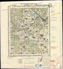
- Description:
- 1938
- Subject:
- Geographic Subject: Likhoslavl', Topical Subject: Soviet Union, and Topical Subject: Maps
- Publisher:
- Главное управление геодезии и картографии при СНК СССР
- Language:
- Russian
- Date Created:
- 1941
- Identifier:
- VAC9619-002852
- Genre:
- Military Maps and Topographic Maps
- Geographic Location:
- Coordinates: 57, 35.25, 57.167, 35.5
- Related URL:
- Download GeoTIFF: https://drive.google.com/file/d/1_1d7nZrOWqXaKo7w86AM92cd9KGEpK5Y/view?usp=sharing and Catalog URL: http://iucat.iu.edu/catalog/5020131
- Abstract:
- Modern area represented: Лихославль (Likhoslavl'), Тверская область (Tverskaya oblast), Russia
- Call Number:
- GM G7000 s50 .S68 sheet O-36-107-D
- City:
- Лихославль (Likhoslavl')
- Copyright Holder:
- No Copyright - United States
- Country:
- СССР (USSR)
- State/Province:
- Новоторжский район (Novotorzhsky district), Лихославльский район (Likhoslavlsky district), Калининская область (Kalinin oblast), and Медновский район (Mednov...
- Physical Description:
- Scale: 1:50,000
- Persistent URL:
- http://purl.dlib.indiana.edu/iudl/images/VAC9619/VAC9619-002852
- Provenance:
- M. I. Map Library
-
- Description:
- 1938
- Subject:
- Topical Subject: Soviet Union, Geographic Subject: Tereshkino, and Topical Subject: Maps
- Publisher:
- Главное управление геодезии и картографии при СНК СССР
- Language:
- Russian
- Date Created:
- 1941
- Identifier:
- VAC9619-002851
- Genre:
- Topographic Maps and Military Maps
- Geographic Location:
- Coordinates: 57, 35, 57.167, 35.25
- Related URL:
- Download GeoTIFF: https://drive.google.com/file/d/1ZxCCx26V9irbFiMxspZfiE2B2D0mKpmo/view?usp=sharing and Catalog URL: http://iucat.iu.edu/catalog/5020131
- Abstract:
- Modern area represented: Терешкино (Tereshkino), Тверская область (Tverskaya oblast), Russia
- Call Number:
- GM G7000 s50 .S68 sheet O-36-107-C
- Caption:
- Captured map
- City:
- Терешкино (Tereshkino)
- Copyright Holder:
- No Copyright - United States
- Country:
- СССР (USSR)
- State/Province:
- Калининская область (Kalinin oblast), Медновский район (Mednovsky district), Лихославльский район (Likhoslavlsky district), and Новоторжский район (Novotorzh...
- Physical Description:
- Scale: 1:50,000
- Persistent URL:
- http://purl.dlib.indiana.edu/iudl/images/VAC9619/VAC9619-002851
- Provenance:
- Army Map Service Library, OMAHA, Library of Congress Geography & Map Division
-
- Description:
- 1938
- Subject:
- Topical Subject: Soviet Union, Topical Subject: Maps, and Geographic Subject: Bol’shoye Ploskoye
- Publisher:
- Главное управление геодезии и картографии при СНК СССР
- Language:
- Russian
- Date Created:
- 1941
- Identifier:
- VAC9619-002850
- Genre:
- Topographic Maps and Military Maps
- Geographic Location:
- Coordinates: 57.167, 35.25, 57.333, 35.5
- Related URL:
- Catalog URL: http://iucat.iu.edu/catalog/5020131 and Download GeoTIFF: https://drive.google.com/file/d/1QbTVGhpTcwzq68sfhurfKNa6ZaCBc5b9/view?usp=sharing
- Abstract:
- Modern area represented: Большое Плоское (Bol’shoye Ploskoye), Тверская область (Tverskaya oblast), Russia
- Call Number:
- GM G7000 s50 .S68 sheet O-36-107-B
- Caption:
- Captured map
- City:
- Большое Плоское (Bol’shoye Ploskoye)
- Copyright Holder:
- No Copyright - United States
- Country:
- СССР (USSR)
- State/Province:
- Новоторжский район (Novotorzhsky district), Лихославльский район (Likhoslavlsky district), and Калининская область (Kalinin oblast)
- Physical Description:
- Scale: 1:50,000
- Persistent URL:
- http://purl.dlib.indiana.edu/iudl/images/VAC9619/VAC9619-002850
- Provenance:
- DMA Topographic Center, Army Map Service Library, OMAHA, Library of Congress Geography & Map Division
-
- Description:
- 1938
- Subject:
- Topical Subject: Soviet Union, Geographic Subject: Tysyatskoye, and Topical Subject: Maps
- Publisher:
- Главное управление геодезии и картографии при СНК СССР
- Language:
- Russian
- Date Created:
- 1941
- Identifier:
- VAC9619-002848
- Genre:
- Topographic Maps and Military Maps
- Geographic Location:
- Coordinates: 57, 34.25, 57.167, 34.5
- Related URL:
- Download GeoTIFF: https://drive.google.com/file/d/18o3IQmUtRccKjPuKL9e4V3ItSU5attPq/view?usp=sharing and Catalog URL: http://iucat.iu.edu/catalog/5020131
- Abstract:
- Modern area represented: Тысяцкое (Tysyatskoye), Тверская область (Tverskaya oblast), Russia
- Call Number:
- GM G7000 s50 .S68 sheet O-36-105-D
- Caption:
- Для служебного пользования and Captured map
- City:
- Тысяцкое (Tysyatskoye)
- Copyright Holder:
- No Copyright - United States
- Country:
- СССР (USSR)
- State/Province:
- Есеновичский район (Yesenovichsky district), Каменский район (Kamensky district), Новоторжский район (Novotorzhsky district), and Калининская область (Kalini...
- Physical Description:
- Scale: 1:50,000
- Persistent URL:
- http://purl.dlib.indiana.edu/iudl/images/VAC9619/VAC9619-002848
- Provenance:
- DMA Topographic Center, Army Map Service Library, OMAHA, Library of Congress Geography & Map Division
-

- Description:
- 1938
- Subject:
- Topical Subject: Maps, Topical Subject: Soviet Union, and Geographic Subject: Kuvshinovo
- Publisher:
- Главное управление геодезии и картографии при СНК СССР
- Language:
- Russian
- Date Created:
- 1941
- Identifier:
- VAC9619-002847
- Genre:
- Topographic Maps and Military Maps
- Geographic Location:
- Coordinates: 57, 34, 57.167, 34.25
- Related URL:
- Download GeoTIFF: https://drive.google.com/file/d/1in4LtbLjyxKHh3Rbboj7wn1NeMv5fuhi/view?usp=sharing and Catalog URL: http://iucat.iu.edu/catalog/5020131
- Abstract:
- Modern area represented: Кувшиново (Kuvshinovo), Тверская область (Tverskaya oblast), Russia
- Call Number:
- GM G7000 s50 .S68 sheet O-36-105-C
- Caption:
- Для служебного пользования
- City:
- Каменка (Kamenka)
- Copyright Holder:
- No Copyright - United States
- Country:
- СССР (USSR)
- State/Province:
- Калининская область (Kalinin oblast), Каменский район (Kamensky district), and Есеновичский район (Yesenovichsky district)
- Physical Description:
- Scale: 1:50,000
- Persistent URL:
- http://purl.dlib.indiana.edu/iudl/images/VAC9619/VAC9619-002847
- Provenance:
- CIA Map Branch -- Received, Library of Congress Geography & Map Division
-

- Description:
- 1938
- Subject:
- Topical Subject: Soviet Union, Geographic Subject: Latygorevo, and Topical Subject: Maps
- Publisher:
- Главное управление геодезии и картографии при СНК СССР
- Language:
- Russian
- Date Created:
- 1941
- Identifier:
- VAC9619-002846
- Genre:
- Military Maps and Topographic Maps
- Geographic Location:
- Coordinates: 57.167, 34.25, 57.333, 34.5
- Related URL:
- Catalog URL: http://iucat.iu.edu/catalog/5020131 and Download GeoTIFF: https://drive.google.com/file/d/1-3MDS2qOzX9VCvXrk_BaHs9FQXTrZArY/view?usp=sharing
- Abstract:
- Modern area represented: Латыгорево (Latygorevo), Тверская область (Tverskaya oblast), Russia
- Call Number:
- GM G7000 s50 .S68 sheet O-36-105-B
- Caption:
- Для служебного пользования
- City:
- Латыгорево (Latygorevo)
- Copyright Holder:
- No Copyright - United States
- Country:
- СССР (USSR)
- State/Province:
- Новоторжский район (Novotorzhsky district), Калининская область (Kalinin oblast), Есеновичский район (Yesenovichsky district), and Каменский район (Kamensky ...
- Physical Description:
- Scale: 1:50,000
- Persistent URL:
- http://purl.dlib.indiana.edu/iudl/images/VAC9619/VAC9619-002846
- Provenance:
- CIA Map Branch -- Received, Library of Congress Geography & Map Division
-

- Description:
- 1938
- Subject:
- Geographic Subject: Yesenovichi, Topical Subject: Maps, and Topical Subject: Soviet Union
- Publisher:
- Главное управление геодезии и картографии при СНК СССР
- Language:
- Russian
- Date Created:
- 1941
- Identifier:
- VAC9619-002845
- Genre:
- Military Maps and Topographic Maps
- Geographic Location:
- Coordinates: 57.167, 34, 57.333, 34.25
- Related URL:
- Download GeoTIFF: https://drive.google.com/file/d/10NM23ZlS_eT3uVkeRBZs9jwUFzxm4649/view?usp=sharing and Catalog URL: http://iucat.iu.edu/catalog/5020131
- Abstract:
- Modern area represented: Есеновичи (Yesenovichi), Тверская область (Tverskaya oblast), Russia
- Call Number:
- GM G7000 s50 .S68 sheet O-36-105-A
- Caption:
- Для служебного пользования
- City:
- Есеновичи (Yesenovichi)
- Copyright Holder:
- No Copyright - United States
- Country:
- СССР (USSR)
- State/Province:
- Каменский район (Kamensky district), Калининская область (Kalinin oblast), and Есеновичский район (Yesenovichsky district)
- Physical Description:
- Scale: 1:50,000
- Persistent URL:
- http://purl.dlib.indiana.edu/iudl/images/VAC9619/VAC9619-002845
- Provenance:
- DMA Topographic Center, Army Map Service Library, OMAHA, Library of Congress Geography & Map Division
-
- Description:
- 1939
- Subject:
- Topical Subject: Soviet Union, Topical Subject: Maps, and Geographic Subject: Sopkovo
- Publisher:
- Главное управление геодезии и картографии при СНК СССР
- Language:
- Russian
- Date Created:
- 1941
- Identifier:
- VAC9619-002844
- Genre:
- Topographic Maps and Military Maps
- Geographic Location:
- Coordinates: 57, 33.75, 57.167, 34
- Related URL:
- Catalog URL: http://iucat.iu.edu/catalog/5020131 and Download GeoTIFF: https://drive.google.com/file/d/18FH-llDMmXXbl0gZPsN4umcqhipvl5E2/view?usp=sharing
- Abstract:
- Modern area represented: Сопково (Sopkovo), Тверская область (Tverskaya oblast), Russia
- Call Number:
- GM G7000 s50 .S68 sheet O-36-104-D
- Caption:
- Для служебного пользования
- City:
- Сапково (Sapkovo)
- Copyright Holder:
- No Copyright - United States
- Country:
- СССР (USSR)
- State/Province:
- Калининская область (Kalinin oblast), Каменский район (Kamensky district), Есеновичский район (Yesenovichsky district), Кировский район (Kirov district), and...
- Physical Description:
- Scale: 1:50,000
- Persistent URL:
- http://purl.dlib.indiana.edu/iudl/images/VAC9619/VAC9619-002844
- Provenance:
- DMA Topographic Center, Army Map Service Library, OMAHA, Library of Congress Geography & Map Division
-
- Description:
- 1939
- Subject:
- Topical Subject: Soviet Union, Topical Subject: Maps, and Geographic Subject: Zhdanovo
- Publisher:
- Главное управление геодезии и картографии при СНК СССР
- Language:
- Russian
- Date Created:
- 1941
- Identifier:
- VAC9619-002843
- Genre:
- Topographic Maps and Military Maps
- Geographic Location:
- Coordinates: 57, 33.5, 57.167, 33.75
- Related URL:
- Download GeoTIFF: https://drive.google.com/file/d/1DKZWkVtJ-WcAO8M4AdsJrVYtwiJrUlWz/view?usp=sharing and Catalog URL: http://iucat.iu.edu/catalog/5020131
- Abstract:
- Modern area represented: Жданово (Zhdanovo), Тверская область (Tverskaya oblast), Russia
- Call Number:
- GM G7000 s50 .S68 sheet O-36-104-C
- Caption:
- Для служебного пользования
- City:
- Жданово (Zhdanovo)
- Copyright Holder:
- No Copyright - United States
- Country:
- СССР (USSR)
- State/Province:
- Калининская область (Kalinin oblast) and РСФСР (RSFSR)
- Physical Description:
- Scale: 1:50,000
- Persistent URL:
- http://purl.dlib.indiana.edu/iudl/images/VAC9619/VAC9619-002843
- Provenance:
- DMA Topographic Center, Army Map Service Library, OMAHA, Library of Congress Geography & Map Division
-
- Description:
- 1939
- Subject:
- Geographic Subject: Trestino, Topical Subject: Maps, and Topical Subject: Soviet Union
- Publisher:
- Главное управление геодезии и картографии при СНК СССР
- Language:
- Russian
- Date Created:
- 1941
- Identifier:
- VAC9619-002842
- Genre:
- Military Maps and Topographic Maps
- Geographic Location:
- Coordinates: 57.167, 33.5, 57.333, 33.75
- Related URL:
- Download GeoTIFF: https://drive.google.com/file/d/1Q8QNL9ywxI185SLMEpXABf5klssd-STW/view?usp=sharing and Catalog URL: http://iucat.iu.edu/catalog/5020131
- Abstract:
- Modern area represented: Трестино (Trestino), Тверская область (Tverskaya oblast), Russia
- Call Number:
- GM G7000 s50 .S68 sheet O-36-104-A
- Caption:
- Для служебного пользования
- City:
- Трестино (Trestino)
- Copyright Holder:
- No Copyright - United States
- Country:
- СССР (USSR)
- State/Province:
- Есеновичский район (Yesenovichsky district), Фировский район (Firovsky district), Осташковский район (Ostashkovsky district), and Калининская область (Kalini...
- Physical Description:
- Scale: 1:50,000
- Persistent URL:
- http://purl.dlib.indiana.edu/iudl/images/VAC9619/VAC9619-002842
- Provenance:
- DMA Topographic Center, Army Map Service Library, OMAHA, Library of Congress Geography & Map Division
-
- Description:
- 1939
- Subject:
- Topical Subject: Soviet Union, Topical Subject: Maps, and Geographic Subject: Kravotyn'
- Publisher:
- Главное управление геодезии и картографии при СНК СССР
- Language:
- Russian
- Date Created:
- 1941
- Identifier:
- VAC9619-002841
- Genre:
- Topographic Maps and Military Maps
- Geographic Location:
- Coordinates: 57.167, 33, 57.333, 33.25
- Related URL:
- Download GeoTIFF: https://drive.google.com/file/d/1ES4pkCBJt5r7GmAOEju7JNpB3uXWh-H0/view?usp=sharing and Catalog URL: http://iucat.iu.edu/catalog/5020131
- Abstract:
- Modern area represented: Кравотынь (Kravotyn'), Тверская область (Tverskaya oblast), Russia
- Call Number:
- GM G7000 s50 .S68 sheet O-36-103-A
- Caption:
- Captured map and Для служебного пользования
- City:
- Кравотынь (Kravotyn')
- Copyright Holder:
- No Copyright - United States
- Country:
- СССР (USSR)
- State/Province:
- Калининская область (Kalinin oblast) and Осташковский район (Ostashkovsky district)
- Physical Description:
- Scale: 1:50,000
- Persistent URL:
- http://purl.dlib.indiana.edu/iudl/images/VAC9619/VAC9619-002841
- Provenance:
- DMA Topographic Center, Army Map Service Library, Library of Congress Geography & Map Division
-
- Description:
- 1939
- Subject:
- Topical Subject: Soviet Union, Geographic Subject: Khitino, and Topical Subject: Maps
- Publisher:
- Главное управление геодезии и картографии при СНК СССР
- Language:
- Russian
- Date Created:
- 1941
- Identifier:
- VAC9619-002840
- Genre:
- Topographic Maps and Military Maps
- Geographic Location:
- Coordinates: 57, 32.75, 57.167, 33
- Related URL:
- Catalog URL: http://iucat.iu.edu/catalog/5020131 and Download GeoTIFF: https://drive.google.com/file/d/13eMfofnRHi-hf1T0ZA2QwUnPBArwXQY_/view?usp=sharing
- Abstract:
- Modern area represented: Хитино (Khitino), Тверская область (Tverskaya oblast), Russia
- Call Number:
- GM G7000 s50 .S68 sheet O-36-102-D
- Caption:
- Для служебного пользования
- City:
- Хитино (Khitino)
- Copyright Holder:
- No Copyright - United States
- Country:
- СССР (USSR)
- State/Province:
- Пеновский район (Penovsky district), Осташковский район (Ostashkovsky district), and Калининская область (Kalinin oblast)
- Physical Description:
- Scale: 1:50,000
- Persistent URL:
- http://purl.dlib.indiana.edu/iudl/images/VAC9619/VAC9619-002840
- Provenance:
- DMA Topographic Center, Army Map Service Library, OMAHA, Library of Congress Geography & Map Division, Geographic Names Branch
-
- Description:
- 1939
- Subject:
- Geographic Subject: Orlinka, Topical Subject: Soviet Union, and Topical Subject: Maps
- Publisher:
- Главное управление геодезии и картографии при СНК СССР
- Language:
- Russian
- Date Created:
- 1941
- Identifier:
- VAC9619-002839
- Genre:
- Military Maps and Topographic Maps
- Geographic Location:
- Coordinates: 57, 32.5, 57.167, 32.75
- Related URL:
- Catalog URL: http://iucat.iu.edu/catalog/5020131 and Download GeoTIFF: https://drive.google.com/file/d/1a5hIpn0hev_QVzALzrL8Jwm5GE6-XZcv/view?usp=sharing
- Abstract:
- Modern area represented: Орлинка (Orlinka), Тверская область (Tverskaya oblast), Russia
- Call Number:
- GM G7000 s50 .S68 sheet O-36-102-C
- Caption:
- Для служебного пользования
- City:
- Орлинка (Orlinka)
- Copyright Holder:
- No Copyright - United States
- Country:
- СССР (USSR)
- State/Province:
- Осташковский район (Ostashkovsky district), Пеновский район (Penovsky district), and Калининская область (Kalinin oblast)
- Physical Description:
- Scale: 1:50,000
- Persistent URL:
- http://purl.dlib.indiana.edu/iudl/images/VAC9619/VAC9619-002839
- Provenance:
- DMA Topographic Center, Army Map Service Library, OMAHA, Library of Congress Geography & Map Division
-
- Description:
- 1939
- Subject:
- Geographic Subject: Kartun’, Topical Subject: Maps, and Topical Subject: Soviet Union
- Publisher:
- Главное управление геодезии и картографии при СНК СССР
- Language:
- Russian
- Date Created:
- 1941
- Identifier:
- VAC9619-002838
- Genre:
- Military Maps and Topographic Maps
- Geographic Location:
- Coordinates: 57.167, 32.75, 57.333, 33
- Related URL:
- Catalog URL: http://iucat.iu.edu/catalog/5020131 and Download GeoTIFF: https://drive.google.com/file/d/1XBWO2Y3c-O9r7vQMy-JiPVCmnIm8xPAY/view?usp=sharing
- Abstract:
- Modern area represented: Картунь (Kartun’), Тверская область (Tverskaya oblast), Russia
- Call Number:
- GM G7000 s50 .S68 sheet O-36-102-B
- Caption:
- Для служебного пользования
- City:
- Картунь (Kartun’)
- Copyright Holder:
- No Copyright - United States
- Country:
- СССР (USSR)
- State/Province:
- Осташковский район (Ostashkovsky district) and Калининская область (Kalinin oblast)
- Physical Description:
- Scale: 1:50,000
- Persistent URL:
- http://purl.dlib.indiana.edu/iudl/images/VAC9619/VAC9619-002838
- Provenance:
- DMA Topographic Center, Army Map Service Library, OMAHA, Library of Congress Geography & Map Division
-
- Description:
- 1939
- Subject:
- Topical Subject: Soviet Union, Geographic Subject: Kokovkino, and Topical Subject: Maps
- Publisher:
- Главное управление геодезии и картографии при СНК СССР
- Language:
- Russian
- Date Created:
- 1941
- Identifier:
- VAC9619-002837
- Genre:
- Topographic Maps and Military Maps
- Geographic Location:
- Coordinates: 57.167, 32.5, 57.333, 32.75
- Related URL:
- Catalog URL: http://iucat.iu.edu/catalog/5020131 and Download GeoTIFF: https://drive.google.com/file/d/14OEiZ6HQvQugXqeydMOpnvxaMe3ARFWE/view?usp=sharing
- Abstract:
- Modern area represented: Коковкино (Kokovkino), Тверская область (Tverskaya oblast), Russia
- Call Number:
- GM G7000 s50 .S68 sheet O-36-102-A
- Caption:
- Для служебного пользования
- City:
- Коковкино (Kokovkino)
- Copyright Holder:
- No Copyright - United States
- Country:
- СССР (USSR)
- State/Province:
- Калининская область (Kalinin oblast), Осташковский район (Ostashkovsky district), Пеновский район (Penovsky district), Ленинградская область (Leningrad oblas...
- Physical Description:
- Scale: 1:50,000
- Persistent URL:
- http://purl.dlib.indiana.edu/iudl/images/VAC9619/VAC9619-002837
- Provenance:
- DMA Topographic Center, Army Map Service Library, OMAHA, Library of Congress Geography & Map Division, Geographic Names Branch
-
- Description:
- 1939
- Subject:
- Topical Subject: Maps, Topical Subject: Soviet Union, and Geographic Subject: Staritsa
- Publisher:
- Главное управление геодезии и картографии при СНК СССР
- Language:
- Russian
- Date Created:
- 1941
- Identifier:
- VAC9619-002834
- Genre:
- Military Maps and Topographic Maps
- Geographic Location:
- Coordinates: 57.167, 31.75, 57.333, 32
- Related URL:
- Catalog URL: http://iucat.iu.edu/catalog/5020131 and Download GeoTIFF: https://drive.google.com/file/d/1fl4L7GVIlX3UXBuwHrA6QVyThKUkZMBU/view?usp=sharing
- Abstract:
- Modern area represented: Старица (Staritsa), Марёвский район (Marevskiy Rayon), Новгородская область (Novgorodskaya oblast), Russia
- Call Number:
- GM G7000 s50 .S68 sheet O-36-100-B
- Caption:
- Captured map
- City:
- Старица (Staritsa)
- Copyright Holder:
- No Copyright - United States
- Country:
- СССР (USSR)
- State/Province:
- Ленинградская область (Leningrad oblast) and Молвотицкий район (Molvotitsky district)
- Physical Description:
- Scale: 1:50,000
- Persistent URL:
- http://purl.dlib.indiana.edu/iudl/images/VAC9619/VAC9619-002834
- Provenance:
- Army Map Service Library, OMAHA, Library of Congress Geography & Map Division
-
- Description:
- 1939
- Subject:
- Geographic Subject: Istrubishche, Topical Subject: Soviet Union, and Topical Subject: Maps
- Publisher:
- Главное управление геодезии и картографии при СНК СССР
- Language:
- Russian
- Date Created:
- 1941
- Identifier:
- VAC9619-002833
- Genre:
- Topographic Maps and Military Maps
- Geographic Location:
- Coordinates: 57.167, 31.5, 57.333, 31.75
- Related URL:
- Download GeoTIFF: https://drive.google.com/file/d/1b9q-yatEjdPCUBdxiBJVfjZi7BvM-NFz/view?usp=sharing and Catalog URL: http://iucat.iu.edu/catalog/5020131
- Abstract:
- Modern area represented: Иструбище (Istrubishche), Новгородская область (Novgorodskaya oblast), Russia
- Call Number:
- GM G7000 s50 .S68 sheet O-36-100-A
- Caption:
- Captured map
- City:
- Иструбище (Istrubishche)
- Copyright Holder:
- No Copyright - United States
- Country:
- СССР (USSR)
- State/Province:
- Ленинградская область (Leningrad oblast), Поддорский район (Poddorsky district), Молвотицкий район (Molvotitsky district), Холмский район (Kholmsky district)...
- Physical Description:
- Scale: 1:50,000
- Persistent URL:
- http://purl.dlib.indiana.edu/iudl/images/VAC9619/VAC9619-002833
- Provenance:
- DMA Topographic Center, Army Map Service Library, OMAHA, Library of Congress Geography & Map Division
-
- Description:
- 1869
- Subject:
- Geographic Subject: Týniště nad Orlicí, Topical Subject: Soviet Union, and Topical Subject: Maps
- Publisher:
- Генеральный штаб Красной Армии
- Language:
- Russian
- Date Created:
- 1941
- Identifier:
- VAC9619-002677
- Genre:
- Topographic Maps and Military Maps
- Geographic Location:
- Coordinates: 50.0, 16.0, 50.3333, 16.5
- Related URL:
- Download GeoTIFF: https://drive.google.com/file/d/1DVUpsS9Unf_spFh6JK77AQKXw7ADjRAS/view?usp=sharing and Catalog URL: https://iucat.iu.edu/catalog/5020129
- Abstract:
- Modern area represented: Týniště nad Orlicí, Hradec Králové Region, Czech Republic
- Call Number:
- G7000 s100 .S7 sheet M-33-69
- City:
- Тыниште (Týniště)
- Copyright Holder:
- No Copyright - United States
- Country:
- Германия (Germany)
- State/Province:
- Протекторат Богемии и Моравии (Protectorate of Bohemia and Moravia)
- Physical Description:
- Scale: 1:100,000
- Persistent URL:
- http://purl.dlib.indiana.edu/iudl/images/VAC9619/VAC9619-002677
- Provenance:
- DMA Topographic Center, Army Map Service Library, Geographic Names Branch
-
- Description:
- 1881
- Subject:
- Topical Subject: Soviet Union, Topical Subject: Maps, and Geographic Subject: Broumov
- Publisher:
- Генеральный штаб Красной Армии
- Language:
- Russian
- Date Created:
- 1941
- Identifier:
- VAC9619-002673
- Genre:
- Military Maps and Topographic Maps
- Geographic Location:
- Coordinates: 50.3333, 16.0, 50.6667, 16.5
- Related URL:
- Catalog URL: https://iucat.iu.edu/catalog/5020129 and Download GeoTIFF: https://drive.google.com/file/d/1vL-_2yzJz51i8Sl-L7gVn481HG8bylvt/view?usp=sharing
- Abstract:
- Modern area represented: Broumov, Hradec Králové region, Czech Republic
- Call Number:
- G7000 s100 .S7 sheet M-33-57
- City:
- Браунау (Braunau)
- Copyright Holder:
- No Copyright - United States
- Country:
- Германия (Germany)
- State/Province:
- Протекторат Богемии и Моравии (Protectorate of Bohemia and Moravia)
- Physical Description:
- Scale: 1:100,000
- Persistent URL:
- http://purl.dlib.indiana.edu/iudl/images/VAC9619/VAC9619-002673
- Provenance:
- DMA Topographic Center, Army Map Service Library
-

- Description:
- 1881
- Subject:
- Topical Subject: Soviet Union, Topical Subject: Maps, and Geographic Subject: Wałbrzych
- Publisher:
- Генеральный штаб Красной Армии
- Language:
- Russian
- Date Created:
- 1941
- Identifier:
- VAC9619-002669
- Genre:
- Topographic Maps and Military Maps
- Geographic Location:
- Coordinates: 50.667, 16, 51, 16.5
- Related URL:
- Download GeoTIFF: https://drive.google.com/file/d/1dqILe5GxCSjBkAQ_koaLdjUsoxZylSen/view?usp=sharing and Catalog URL: https://iucat.iu.edu/catalog/5020129
- Abstract:
- Modern area represented: Wałbrzych, Lower Silesian province, Poland
- Call Number:
- G7000 s100 .S7 sheet M-33-45
- City:
- Вальденбург (Waldenburg)
- Copyright Holder:
- No Copyright - United States
- Country:
- Германия (Germany)
- Physical Description:
- Scale: 1:100,000
- Persistent URL:
- http://purl.dlib.indiana.edu/iudl/images/VAC9619/VAC9619-002669
- Provenance:
- DMA Topographic Center, Army Map Service Library
-

- Subject:
- Topical Subject: Soviet Union, Geographic Subject: Leszkowice, and Topical Subject: Maps
- Publisher:
- Генеральный штаб Красной Армии
- Language:
- Russian
- Date Created:
- 1941
- Identifier:
- VAC9619-002639
- Genre:
- Topographic Maps and Military Maps
- Geographic Location:
- Coordinates: 51.5, 22.5, 51.667, 22.75
- Related URL:
- Download GeoTIFF: https://drive.google.com/file/d/1zxluSGJ01FtlvAWFM_egGfRn0kedbyCP/view?usp=sharing and Catalog URL: http://iucat.iu.edu/catalog/5020131
- Abstract:
- Modern area represented: Лешковице (Leszkowice), Poland
- Call Number:
- GM G7000 s50 .S68 sheet M-34-22-A
- City:
- Лешковице (Leszkowice)
- Copyright Holder:
- No Copyright - United States
- Country:
- Область государственных интересов Германии (Region of German state interest)
- Physical Description:
- Scale: 1:50,000
- Persistent URL:
- http://purl.dlib.indiana.edu/iudl/images/VAC9619/VAC9619-002639
- Provenance:
- DMA Topographic Center, Army Map Service Library, OMAHA, Library of Congress Geography & Map Division
-
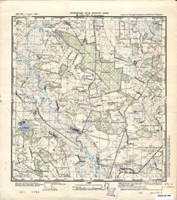
- Subject:
- Topical Subject: Maps, Topical Subject: Soviet Union, and Geographic Subject: Leszkowice
- Publisher:
- Генеральный штаб РККА
- Language:
- Russian
- Date Created:
- 1941
- Identifier:
- VAC9619-002638
- Genre:
- Topographic Maps and Military Maps
- Geographic Location:
- Coordinates: 51.5, 22.5, 51.667, 22.75
- Related URL:
- Catalog URL: http://iucat.iu.edu/catalog/5020131 and Download GeoTIFF: https://drive.google.com/file/d/1-ru48E4UYDJBvNku10aWjihr3PA6Tj6i/view?usp=sharing
- Abstract:
- Modern area represented: Leszkowice, Poland
- Call Number:
- GM G7000 s50 .S68 sheet M-34-22-A
- City:
- Лешковице (Leszkowice)
- Copyright Holder:
- No Copyright - United States
- Country:
- Область государственных интересов Германии (Region of German state interest)
- Physical Description:
- Scale: 1:50,000
- Persistent URL:
- http://purl.dlib.indiana.edu/iudl/images/VAC9619/VAC9619-002638
-
- Subject:
- Topical Subject: Maps, Topical Subject: Soviet Union, and Geographic Subject: Holeszów
- Publisher:
- Генеральный штаб Красной Армии
- Language:
- Russian
- Date Created:
- 1941
- Identifier:
- VAC9619-002637
- Genre:
- Topographic Maps and Military Maps
- Geographic Location:
- Coordinates: 51.667, 23.25, 51.833, 23.5
- Related URL:
- Download GeoTIFF: https://drive.google.com/file/d/1i3ZkibMdOa8Ml_mse338jgWFNAv3twmg/view?usp=sharing and Catalog URL: http://iucat.iu.edu/catalog/5020131
- Abstract:
- Modern area represented: Голешув (Holeszów), Poland
- Call Number:
- GM G7000 s50 .S68 sheet M-34-11-D
- City:
- Голешув (Holeszów)
- Copyright Holder:
- No Copyright - United States
- Country:
- Область государственных интересов Германии (Region of German state interest)
- Physical Description:
- Scale: 1:50,000
- Persistent URL:
- http://purl.dlib.indiana.edu/iudl/images/VAC9619/VAC9619-002637
- Provenance:
- DMA Topographic Center, Army Map Service Library, OMAHA, Library of Congress Geography & Map Division
-
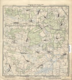
- Subject:
- Geographic Subject: Holeszów, Topical Subject: Soviet Union, and Topical Subject: Maps
- Publisher:
- Генеральный штаб Красной Армии
- Language:
- Russian
- Date Created:
- 1941
- Identifier:
- VAC9619-002636
- Genre:
- Topographic Maps and Military Maps
- Geographic Location:
- Coordinates: 51.667, 23.25, 51.833, 23.5
- Related URL:
- Download GeoTIFF: https://drive.google.com/file/d/1oBBHT5MIHBy5239bvVZ6vbL9acZawCga/view?usp=sharing and Catalog URL: http://iucat.iu.edu/catalog/5020131
- Abstract:
- Modern area represented: Holeszów, Poland
- Call Number:
- GM G7000 s50 .S68 sheet M-34-11-D
- City:
- Голешув (Holeszów)
- Copyright Holder:
- No Copyright - United States
- Country:
- Область государственных интересов Германии (Region of German state interest)
- Physical Description:
- Scale: 1:50,000
- Persistent URL:
- http://purl.dlib.indiana.edu/iudl/images/VAC9619/VAC9619-002636
-
- Subject:
- Geographic Subject: Piszczac, Topical Subject: Maps, and Topical Subject: Soviet Union
- Publisher:
- Генеральный штаб Красной Армии
- Language:
- Russian
- Date Created:
- 1941
- Identifier:
- VAC9619-002635
- Genre:
- Topographic Maps and Military Maps
- Geographic Location:
- Coordinates: 51.833, 23.25, 52, 23.5
- Related URL:
- Download GeoTIFF: https://drive.google.com/file/d/142t5RKNxXqKne56w93rpyltp66DAMAU4/view?usp=sharing and Catalog URL: http://iucat.iu.edu/catalog/5020131
- Abstract:
- Modern area represented: Piszczac, Poland
- Call Number:
- GM G7000 s50 .S68 sheet M-34-11-B
- City:
- Пищац (Piszczac)
- Copyright Holder:
- No Copyright - United States
- Country:
- Область государственных интересов Германии (Region of German state interest)
- Physical Description:
- Scale: 1:50,000
- Persistent URL:
- http://purl.dlib.indiana.edu/iudl/images/VAC9619/VAC9619-002635
-
- Subject:
- Geographic Subject: Łomazy, Topical Subject: Soviet Union, and Topical Subject: Maps
- Publisher:
- Генеральный штаб РККА
- Language:
- Russian
- Date Created:
- 1941
- Identifier:
- VAC9619-002634
- Genre:
- Topographic Maps and Military Maps
- Geographic Location:
- Coordinates: 51.833, 23, 52, 23.25
- Related URL:
- Catalog URL: http://iucat.iu.edu/catalog/5020131 and Download GeoTIFF: https://drive.google.com/file/d/1RbkoScJXhEaptPl4JEHZVYCnCX9rDzQX/view?usp=sharing
- Abstract:
- Modern area represented: Ломазы (Łomazy), Poland
- Call Number:
- GM G7000 s50 .S68 sheet M-34-11-A
- City:
- Ломазы (Łomazy)
- Copyright Holder:
- No Copyright - United States
- Country:
- Область государственных интересов Германии (Region of German state interest)
- Physical Description:
- Scale: 1:50,000
- Persistent URL:
- http://purl.dlib.indiana.edu/iudl/images/VAC9619/VAC9619-002634
- Provenance:
- DMA Topographic Center, Army Map Service Library, OMAHA, Library of Congress Geography & Map Division
-

- Subject:
- Geographic Subject: Międzyrzec, Topical Subject: Soviet Union, and Topical Subject: Maps
- Publisher:
- Генеральный штаб Красной Армии
- Language:
- Russian
- Date Created:
- 1941
- Identifier:
- VAC9619-002631
- Genre:
- Military Maps and Topographic Maps
- Geographic Location:
- Coordinates: 51.833, 22.75, 52, 23
- Related URL:
- Catalog URL: http://iucat.iu.edu/catalog/5020131 and Download GeoTIFF: https://drive.google.com/file/d/1yhicLdyW1G1TdFyU-rylfj9cH98TGr91/view?usp=sharing
- Abstract:
- Modern area represented: Międzyrzec, Poland.
- Call Number:
- GM G7000 S50 .S68 sheet M-34-10-B
- City:
- Мендзыжец (Międzyrzec)
- Copyright Holder:
- No Copyright - United States
- Country:
- Область государственных интересов Германии (Region of German state interest)
- Physical Description:
- Scale: 1:50,000
- Persistent URL:
- http://purl.dlib.indiana.edu/iudl/images/VAC9619/VAC9619-002631
- Provenance:
- DMA Topographic Center, Army Map Service Library, OMAHA, Library of Congress G & M Division
-
- Subject:
- Geographic Subject: Wohyń, Topical Subject: Soviet Union, and Topical Subject: Maps
- Publisher:
- Генеральный штаб Красной Армии
- Language:
- Russian
- Date Created:
- 1941
- Identifier:
- VAC9619-002633
- Genre:
- Military Maps and Topographic Maps
- Geographic Location:
- Coordinates: 51.667, 22.75, 51.833, 23
- Related URL:
- Catalog URL: http://iucat.iu.edu/catalog/5020131 and Download GeoTIFF: https://drive.google.com/file/d/10tZQdaKok1oVwDpVD8i2ILhIrd7EE95n/view?usp=sharing
- Abstract:
- Modern area represented: Wohyń, Poland
- Call Number:
- GM G7000 s50 .S68 sheet M-34-10-D
- City:
- Вогынь (Wohyń)
- Copyright Holder:
- No Copyright - United States
- Country:
- Область государственных интересов Германии (Region of German state interest)
- Physical Description:
- Scale: 1:50,000
- Persistent URL:
- http://purl.dlib.indiana.edu/iudl/images/VAC9619/VAC9619-002633
- Provenance:
- DMA Topographic Center, Army Map Service Library, OMAHA, Library of Congress Geography & Map Division
-
- Subject:
- Geographic Subject: Kąkolewnica, Topical Subject: Maps, and Topical Subject: Soviet Union
- Publisher:
- Генеральный штаб Красной Армии
- Language:
- Russian
- Date Created:
- 1941
- Identifier:
- VAC9619-002630
- Genre:
- Topographic Maps and Military Maps
- Geographic Location:
- Coordinates: 51.833, 22.5, 52, 22.75
- Related URL:
- Download GeoTIFF: https://drive.google.com/file/d/1FILIrkmOHQz2itcJ6kjwwkWN0bocu87_/view?usp=sharing and Catalog URL: http://iucat.iu.edu/catalog/5020131
- Abstract:
- Modern area represented: Kąkolewnica, Poland
- Call Number:
- GM G7000 s50 .S68 sheet M-34-10-A
- City:
- Конколевница (Kąkolewnica)
- Copyright Holder:
- No Copyright - United States
- Country:
- Область государственных интересов Германии (Region of German state interest)
- Physical Description:
- Scale: 1:50,000
- Persistent URL:
- http://purl.dlib.indiana.edu/iudl/images/VAC9619/VAC9619-002630
- Provenance:
- DMA Topographic Center, Army Map Service Library, OMAHA, Library of Congress Geography & Map Division
-
- Subject:
- Topical Subject: Maps, Geographic Subject: Radzyń Podlaski, and Topical Subject: Soviet Union
- Publisher:
- Генеральный штаб Красной Армии
- Language:
- Russian
- Date Created:
- 1941
- Identifier:
- VAC9619-002632
- Genre:
- Topographic Maps and Military Maps
- Geographic Location:
- Coordinates: 51.667, 22.5, 51.833, 22.75
- Related URL:
- Catalog URL: http://iucat.iu.edu/catalog/5020131 and Download GeoTIFF: https://drive.google.com/file/d/1eKvChcGxPitIgwFsgpgt3HkJhi__H6S_/view?usp=sharing
- Abstract:
- Modern area represented: Радзынь-Подляский (Radzyń Podlaski), Poland
- Call Number:
- GM G7000 s50 .S68 sheet M-34-10-C
- City:
- Радзынь Подляски (Radzyń Podlaski)
- Copyright Holder:
- No Copyright - United States
- Country:
- Область государственных интересов Германии (Region of German state interest)
- Physical Description:
- Scale: 1:50,000
- Persistent URL:
- http://purl.dlib.indiana.edu/iudl/images/VAC9619/VAC9619-002632
- Provenance:
- DMA Topographic Center, Army Map Service Library, OMAHA, Library of Congress Geography & Map Division
-
- Description:
- 1938
- Subject:
- Geographic Subject: Kolezhma, Topical Subject: Maps, and Topical Subject: Soviet Union
- Publisher:
- Главное Управление Геодезии и Картографии при СНК СССР
- Language:
- Russian
- Date Created:
- 1941
- Identifier:
- VAC9619-002629
- Genre:
- Military Maps and Topographic Maps
- Geographic Location:
- Coordinates: 64, 35.5, 64.333, 36
- Related URL:
- Catalog URL: https://iucat.iu.edu/catalog/5020129 and Download GeoTIFF: https://drive.google.com/file/d/1UTip26nPXX54soudKYxJfU64NIEZnnyK/view?usp=sharing
- Abstract:
- Modern area represented: Kolezhma, Republic of Karelia, Russia
- Call Number:
- G7000 s100 .S7 sheet Q-36-144
- Caption:
- Для служебного пользования
- City:
- Колежма (Kolezhma)
- Copyright Holder:
- No Copyright - United States
- Country:
- СССР (USSR)
- State/Province:
- Карело-Финская ССР (Karelo-Finnish Soviet Socialist Republic)
- Physical Description:
- Scale: 1:100,000
- Persistent URL:
- http://purl.dlib.indiana.edu/iudl/images/VAC9619/VAC9619-002629
- Provenance:
- DMA Topographic Center, Army Map Service Library, OMAHA, Geographic Names Branch
-
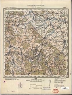
- Description:
- 1881
- Subject:
- Topical Subject: Maps, Geographic Subject: Wałbrzych, and Topical Subject: Soviet Union
- Publisher:
- Генеральный штаб Красной Армии
- Language:
- Russian
- Date Created:
- 1941
- Identifier:
- VAC9619-002612
- Genre:
- Topographic Maps and Military Maps
- Geographic Location:
- Coordinates: 50.66667, 16.0, 51.0, 16.5
- Related URL:
- Download GeoTIFF: https://drive.google.com/file/d/1kFsiMhki6AQE-SCAeAGcI3MVKvGeIKR4/view?usp=sharing and Catalog URL: https://iucat.iu.edu/catalog/5020129
- Abstract:
- Modern area represented: Wałbrzych, Lower Silesian province, Poland
- Call Number:
- G7000 s100 .S7 sheet M-33-45
- City:
- Вальденбург (Waldenburg)
- Copyright Holder:
- No Copyright - United States
- Country:
- Германия (Germany)
- Physical Description:
- Scale: 1:100,000
- Persistent URL:
- http://purl.dlib.indiana.edu/iudl/images/VAC9619/VAC9619-002612
- Provenance:
- DMA Topographic Center, Army Map Service Library, Library of Congress Geography & Map Division
-
- Description:
- 1881
- Subject:
- Topical Subject: Maps, Geographic Subject: Wałbrzych, and Topical Subject: Soviet Union
- Publisher:
- Генеральный штаб Красной Армии
- Language:
- Russian
- Date Created:
- 1941
- Identifier:
- VAC9619-002611
- Genre:
- Military Maps and Topographic Maps
- Geographic Location:
- Coordinates: 50.667, 16, 51, 16.5
- Related URL:
- Catalog URL: https://iucat.iu.edu/catalog/5020129 and Download GeoTIFF: https://drive.google.com/file/d/1YmxgsSmD507KrgT3JLU_e4j1QXzzCA3Y/view?usp=sharing
- Abstract:
- Modern area represented: Wałbrzych, Lower Silesian province, Poland
- Call Number:
- G7000 s100 .S7 sheet M-33-45
- City:
- Вальденбург (Waldenburg)
- Copyright Holder:
- No Copyright - United States
- Country:
- Германия (Germany)
- Physical Description:
- Scale: 1:100,000
- Persistent URL:
- http://purl.dlib.indiana.edu/iudl/images/VAC9619/VAC9619-002611
- Provenance:
- DMA Topographic Center, Library of Congress G & M Division, Army Map Service Library, OMAHA
-
- Description:
- 1887
- Subject:
- Geographic Subject: Legnica, Topical Subject: Soviet Union, and Topical Subject: Maps
- Publisher:
- Генеральный штаб Красной Армии
- Language:
- Russian
- Date Created:
- 1941
- Identifier:
- VAC9619-002607
- Genre:
- Topographic Maps and Military Maps
- Geographic Location:
- Coordinates: 51, 16, 51.333, 16.5
- Related URL:
- Catalog URL: https://iucat.iu.edu/catalog/5020129 and Download GeoTIFF: https://drive.google.com/file/d/1KXLiwoAPM5wGtb60iFqkF_oom1IK570X/view?usp=sharing
- Abstract:
- Modern area represented: Legnica, Lower Silesia province, Poland
- Call Number:
- G7000 s100 .S7 sheet M-33-33
- City:
- Лигниц (Legnica)
- Copyright Holder:
- No Copyright - United States
- Country:
- Германия (Germany)
- Physical Description:
- Scale: 1:100,000
- Persistent URL:
- http://purl.dlib.indiana.edu/iudl/images/VAC9619/VAC9619-002607
- Provenance:
- Geographic Names Branch, DMA Topographic Center, Army Map Service Library
-
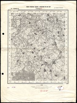
- Description:
- 1938
- Subject:
- Topical Subject: Soviet Union, Geographic Subject: Bolshoye Ploskoye, and Topical Subject: Maps
- Publisher:
- Главное Управление Геодезии и Картографии при СНК СССР
- Language:
- Russian
- Date Created:
- 1941
- Identifier:
- VAC9619-002730
- Genre:
- Topographic Maps and Military Maps
- Geographic Location:
- 57.666667, 35.5 and Coordinates: 57.5, 35.25
- Related URL:
- Download GeoTIFF: https://drive.google.com/file/d/1O9oNQ-2N946R7PqSKefXi5RLKUZDzqDx/view?usp=sharing and Catalog URL: http://iucat.iu.edu/catalog/5020131
- Abstract:
- Modern area represented: Bolshoye Ploskoye, Tver oblast, Russia
- Call Number:
- G7000 s50 .S68 sheet O-36-95-B
- Caption:
- Для служебного пользования
- Copyright Holder:
- No Copyright - United States
- Country:
- СССР (USSR)
- State/Province:
- РСФСР (RSFSR) and Калининская область (Kalinin oblast)
- Physical Description:
- Scale: 1:50,000
- Persistent URL:
- http://purl.dlib.indiana.edu/iudl/images/VAC9619/VAC9619-002730
- Provenance:
- Library of Congress Geography & Map Division
-
- Description:
- 1869
- Subject:
- Topical Subject: Soviet Union, Topical Subject: Maps, and Geographic Subject: Vysoké Mýto
- Publisher:
- Генеральный штаб Красной Армии
- Language:
- Russian
- Date Created:
- 1941
- Identifier:
- VAC9619-002708
- Genre:
- Military Maps and Topographic Maps
- Geographic Location:
- Coordinates: 49.667, 16, 50, 16.5
- Related URL:
- Download GeoTIFF: https://drive.google.com/file/d/1bxbg0QA-Bm4ku60mqvTMMgwr5Qr1bXw2/view?usp=sharing and Catalog URL: https://iucat.iu.edu/catalog/5020129
- Abstract:
- Modern area represented: Vysoké Mýto, Pardubice region, Czech Republic
- Call Number:
- G7000 s100 .S7 sheet M-33-81
- City:
- Високе Мито (Vysoké Mýto)
- Copyright Holder:
- No Copyright - United States
- Country:
- Германия (Germany)
- State/Province:
- Протекторат Богемии и Моравии (Protectorate of Bohemia and Moravia)
- Physical Description:
- Scale: 1:100,000
- Persistent URL:
- http://purl.dlib.indiana.edu/iudl/images/VAC9619/VAC9619-002708
- Provenance:
- DMA Topographic Center, Army Map Service Library, Library of Congress Geography & Map Division, Auswärtiges Amt. Geographischer Dienst, OMAHA
-
- Description:
- 1939
- Subject:
- Topical Subject: Maps, Topical Subject: Soviet Union, and Geographic Subject: Vaganovo
- Publisher:
- Генеральный штаб Красной Армии
- Language:
- Russian
- Date Created:
- 1941
- Identifier:
- VAC9619-002562
- Genre:
- Military Maps and Topographic Maps
- Geographic Location:
- Coordinates: 60, 31, 60.333, 31.5
- Related URL:
- Download GeoTIFF: https://drive.google.com/file/d/1tHbGVqZHZdEJCGXk-kDTi5cgXC54uDTo/view?usp=sharing and Catalog URL: https://iucat.iu.edu/catalog/5020129
- Abstract:
- Modern area represented: Vaganovo, Leningrad oblast, Russia
- Call Number:
- G7000 s100 .S7 sheet P-36-135
- Caption:
- Для служебного пользования
- City:
- Ваганово (Vaganovo)
- Copyright Holder:
- No Copyright - United States
- Country:
- СССР (USSR)
- State/Province:
- Ленинградская область (Leningrad oblast) and РСФСР (RSFSR)
- Physical Description:
- Scale: 1:100,000
- Persistent URL:
- http://purl.dlib.indiana.edu/iudl/images/VAC9619/VAC9619-002562
- Provenance:
- DMA Topographic Center, Army Map Service Library, OMAHA
-
- Subject:
- Topical Subject: Soviet Union, Topical Subject: Maps, and Geographic Subject: Gromovo
- Publisher:
- Генеральный штаб Красной Армии
- Language:
- Russian
- Date Created:
- 1941
- Identifier:
- VAC9619-002557
- Genre:
- Military Maps and Topographic Maps
- Geographic Location:
- Coordinates: 60.667, 30, 61, 30.5
- Related URL:
- Catalog URL: https://iucat.iu.edu/catalog/5020129 and Download GeoTIFF: https://drive.google.com/file/d/1a-uFUlp9aFDhOORlv0ktp3F1buD-AI0U/view?usp=sharing
- Abstract:
- Modern area represented: Громово (Gromovo), Ленинградская область (Leningradskaya oblast), Russia
- Call Number:
- G7000 s100 .S7 sheet P-36-109
- Caption:
- Для служебного пользования and Captured map
- City:
- Саккола (Sakkola)
- Copyright Holder:
- No Copyright - United States
- Country:
- СССР (USSR)
- State/Province:
- РСФСР (RSFSR) and Карело-Финская ССР (Karelo-Finnish Soviet Socialist Republic)
- Physical Description:
- Scale: 1:100,000
- Persistent URL:
- http://purl.dlib.indiana.edu/iudl/images/VAC9619/VAC9619-002557
- Provenance:
- DMA Topographic Center, Army Map Service Library, OMAHA
-
- Description:
- 1938
- Subject:
- Topical Subject: Soviet Union, Topical Subject: Maps, and Geographic Subject: Tipinitsy
- Publisher:
- Itä-Karjalan kartasto
- Language:
- Russian
- Date Created:
- 1941
- Identifier:
- VAC9619-002521
- Genre:
- Topographic Maps and Military Maps
- Geographic Location:
- Coordinates: 62, 35, 62.333, 35.5
- Related URL:
- Download GeoTIFF: https://drive.google.com/file/d/16n70OB4W7s3AZ038yYTIjX6WxSal2LSA/view?usp=sharing and Catalog URL: https://iucat.iu.edu/catalog/5020129
- Abstract:
- Modern area represented: Типиницы (Tipinitsy), Медвежьегорский район (Medvezh'yegorskiy District), Republic of Karelia, Russia
- Call Number:
- G7000 s100 .S7 sheet P-36-71
- Copyright Holder:
- No Copyright - United States
- Country:
- СССР (USSR)
- State/Province:
- Заонежский район (Zaonezhsky district), РСФСР (RSFSR), and Карельская АССР (Karelian Autonomous Soviet Socialist Republic)
- Physical Description:
- Scale: 1:100,000
- Persistent URL:
- http://purl.dlib.indiana.edu/iudl/images/VAC9619/VAC9619-002521
- Provenance:
- DMA Topographic Center, Army Map Service Library, OMAHA
-
- Description:
- 1907
- Subject:
- Geographic Subject: Gelendzhik, Topical Subject: Soviet Union, and Topical Subject: Maps
- Publisher:
- Генеральный штаб Красной Армии
- Language:
- Russian
- Date Created:
- 1941
- Identifier:
- VAC9619-002433
- Genre:
- Topographic Maps and Military Maps
- Geographic Location:
- Coordinates: 44.333, 38, 44.667, 38.5
- Related URL:
- Catalog URL: https://iucat.iu.edu/catalog/5020129 and Download GeoTIFF: https://drive.google.com/file/d/1EEXSYKQqFySK88Xe-nbSaCzfVEmvgljz/view?usp=sharing
- Abstract:
- Modern area represented: Gelendzhik, Russia
- Call Number:
- G7000 s100 .S7 sheet L-37-125
- Caption:
- Для служебного пользования
- City:
- Геленджик (Gelendzhik)
- Copyright Holder:
- No Copyright - United States
- Country:
- СССР (USSR)
- State/Province:
- Краснодарский край (Krasnodar kray) and РСФСР (RSFSR)
- Physical Description:
- Scale: 1:100,000
- Persistent URL:
- http://purl.dlib.indiana.edu/iudl/images/VAC9619/VAC9619-002433
- Provenance:
- DMA Topographic Center, Library of Congress G & M Division, OMAHA, Army Map Service Library
