
Search Constraints
You searched for:
Date Created
1928
Remove constraint Date Created: 1928
Collections
Russian Military Topographic Map Collection
Remove constraint Collections: Russian Military Topographic Map Collection
1 - 7 of 7
Search Results
-

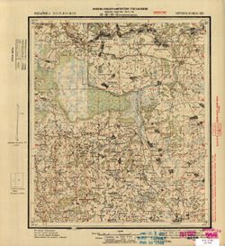
- Description:
- 1922
- Subject:
- Geographic Subject: Voskresensk, Topical Subject: Maps, and Topical Subject: Soviet Union
- Publisher:
- Главное геодезическое управление
- Language:
- Russian
- Date Created:
- 1928
- Identifier:
- VAC9619-001583
- Genre:
- Military Maps and Topographic Maps
- Geographic Location:
- Coordinates: 55.833, 36.5, 56, 37
- Related URL:
- DataCORE Dataset Download: https://datacore.iu.edu/concern/data_sets/mp48sd55j
- Abstract:
- Modern area represented: Voskresensk, Moscow oblast, Russia
- Call Number:
- G7000 s50 .S68 sheet N-37-2-A-Б
- City:
- Воскресенск (Voskresensk)
- Copyright Holder:
- No Copyright - United States
- Country:
- СССР (USSR)
- State/Province:
- Московская область (Moscow oblast) and РСФСР (RSFSR)
- Physical Description:
- Scale: 1:50,000
- Persistent URL:
- http://purl.dlib.indiana.edu/iudl/images/VAC9619/VAC9619-001583
- Provenance:
- Library of Congress Geography & Map Division
-
- Description:
- 1910
- Subject:
- Topical Subject: Maps, Geographic Subject: Polessk, and Topical Subject: Soviet Union
- Publisher:
- Управление военных топографов РККА
- Language:
- Russian
- Date Created:
- 1928
- Identifier:
- VAC9619-003913
- Genre:
- Military Maps and Topographic Maps
- Geographic Location:
- Coordinates: 54.667, 21, 55, 21.5
- Related URL:
- DataCORE Dataset Download: https://datacore.iu.edu/concern/data_sets/6q182k851
- Abstract:
- Modern area represented: Polessk, Kaliningrad oblast, Russia
- Call Number:
- G7000 s100 .S7 sheet N-34-43
- Caption:
- Не подлежит оглашению
- City:
- Лабиау (Labiau)
- Copyright Holder:
- No Copyright - United States
- State/Province:
- Восточная Пруссия (East Prussia) and Кенигсбергская провинция (Königsberg province)
- Physical Description:
- Scale: 1:100,000
- Persistent URL:
- http://purl.dlib.indiana.edu/iudl/images/VAC9619/VAC9619-003913
- Provenance:
- Army Map Service Library, Library of Congress G & M Division, Geographic Names Branch
-

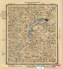
- Description:
- 1908
- Subject:
- Topical Subject: Maps, Geographic Subject: Yantarny, and Topical Subject: Soviet Union
- Publisher:
- Управление военных топографов РККА
- Language:
- Russian
- Date Created:
- 1928
- Identifier:
- VAC9619-003911
- Genre:
- Military Maps and Topographic Maps
- Geographic Location:
- Coordinates: 54.667, 19.5, 55, 20
- Related URL:
- DataCORE Dataset Download: https://datacore.iu.edu/concern/data_sets/1831ck772
- Abstract:
- Modern area represented: Yantarny, Kaliningrad oblast, Russia
- Call Number:
- G7000 s100 .S7 sheet N-34-40
- Caption:
- Не подлежит оглашению
- City:
- Кракстепеллен (Kraxtepellen)
- Copyright Holder:
- No Copyright - United States
- State/Province:
- Восточная Пруссия (East Prussia) and Кенигсбергская провинция (Königsberg province)
- Physical Description:
- Scale: 1:100,000
- Persistent URL:
- http://purl.dlib.indiana.edu/iudl/images/VAC9619/VAC9619-003911
- Provenance:
- CIA Map Branch -- Received, CIA Map Library
-
- Description:
- 1926
- Subject:
- Topical Subject: Maps, Geographic Subject: Chachersk, and Topical Subject: Soviet Union
- Publisher:
- Генеральный штаб Красной Армии
- Language:
- Russian
- Date Created:
- 1928
- Identifier:
- VAC9619-001985
- Genre:
- Topographic Maps and Military Maps
- Geographic Location:
- Coordinates: 52.6667, 30.5, 53, 31
- Related URL:
- DataCORE Dataset Download: https://datacore.iu.edu/concern/data_sets/jq085k66k
- Abstract:
- Modern area represented: Chachersk, Homyel voblasc, Belarus
- Call Number:
- G7000 s100 .S7 sheet N-36-110
- Caption:
- Для служебного пользования
- City:
- Чечерск (Chachersk)
- Copyright Holder:
- No Copyright - United States
- Country:
- СССР (USSR)
- State/Province:
- Белорусская ССР (Byelorussian Soviet Socialist Republic)
- Physical Description:
- Scale: 1:100,000
- Persistent URL:
- http://purl.dlib.indiana.edu/iudl/images/VAC9619/VAC9619-001985
- Provenance:
- DMA Topographic Center, Army Map Service Library, OMAHA
-
- Description:
- 1923
- Subject:
- Topical Subject: Soviet Union, Topical Subject: Maps, and Geographic Subject: Verkhniye Koshevichi
- Publisher:
- Военно-топографическое управление
- Language:
- Russian
- Date Created:
- 1928
- Identifier:
- VAC9619-001257
- Genre:
- Topographic Maps and Military Maps
- Geographic Location:
- Coordinates: 55.167, 30.75, 55.333, 31
- Related URL:
- DataCORE Dataset Download: https://datacore.iu.edu/concern/data_sets/z029p5571
- Abstract:
- Modern area represented: Verkhniye Koshevichi, Smolensk oblast, Russia
- Call Number:
- GM G7000 S50 .S68 N-36-26-B
- Caption:
- Секретно
- City:
- Кошевичи Верхние (Koshevichi Verkhniye)
- Copyright Holder:
- No Copyright - United States
- Country:
- СССР (USSR)
- State/Province:
- Белорусская ССР (Byelorussian Soviet Socialist Republic) and РСФСР (RSFSR)
- Physical Description:
- Scale: 1:50,000
- Persistent URL:
- http://purl.dlib.indiana.edu/iudl/images/VAC9619/VAC9619-001257
- Provenance:
- M. I. Map Library, G000-30, GS, RA
-
- Description:
- 1921
- Subject:
- Topical Subject: Soviet Union, Topical Subject: Maps, and Geographic Subject: Yanovichi
- Publisher:
- Военно-топографическое управление
- Language:
- Russian
- Date Created:
- 1928
- Identifier:
- VAC9619-001256
- Genre:
- Military Maps and Topographic Maps
- Geographic Location:
- Coordinates: 55.167, 30.5, 55.333, 30.75
- Related URL:
- DataCORE Dataset Download: https://datacore.iu.edu/concern/data_sets/4m90dw34k
- Abstract:
- Modern area represented: Yanovichi, Vitebsk oblast, Belarus
- Call Number:
- GM G7000 S50 .S68 N-36-26-A
- Caption:
- Секретно
- City:
- Яновичи (Yanovichi)
- Copyright Holder:
- No Copyright - United States
- Country:
- СССР (USSR)
- State/Province:
- Белорусская ССР (Byelorussian Soviet Socialist Republic)
- Physical Description:
- Scale: 1:50,000
- Persistent URL:
- http://purl.dlib.indiana.edu/iudl/images/VAC9619/VAC9619-001256
- Provenance:
- M. I. Map Library, G000-30
-

- Description:
- 1884
- Subject:
- Topical Subject: Maps, Geographic Subject: Jászapáti, and Topical Subject: Soviet Union
- Publisher:
- Генеральный штаб РККА
- Language:
- Russian
- Date Created:
- 1928
- Identifier:
- VAC9619-000949
- Genre:
- Military Maps and Topographic Maps
- Geographic Location:
- Coordinates: 47.3333, 20, 47.6667, 20.5
- Related URL:
- DataCORE Dataset Download: https://datacore.iu.edu/concern/data_sets/z316q2446
- Abstract:
- Modern area represented: Jászapáti, Jász-Nagykun-Szolnok county, Hungary
- Call Number:
- G7000 s100 .S7 sheet L-34-17
- City:
- Ясапати (Jászapáti)
- Copyright Holder:
- No Copyright - United States
- Country:
- Венгрия (Hungary)
- Physical Description:
- Scale: 1:100,000
- Persistent URL:
- http://purl.dlib.indiana.edu/iudl/images/VAC9619/VAC9619-000949
- Provenance:
- DMA Topographic Center, Army Map Service Library, OMAHA, Atlasblatt, Library of Congress Geography & Map Division
