
Search Constraints
Search Results
-
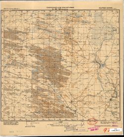
- Description:
- 1935
- Subject:
- Topical Subject: Soviet Union, Topical Subject: Maps, Geographic Subject: Chubutla, and Geographic Subject: Dagestan
- Publisher:
- Генеральный штаб Красной Армии
- Language:
- Russian
- Date Created:
- 1942
- Identifier:
- VAC9619-002248
- Genre:
- Topographic Maps and Military Maps
- Geographic Location:
- Coordinates: 44, 46, 44.3333, 46.5
- Related URL:
- Catalog URL: https://iucat.iu.edu/catalog/5020129 and Download GeoTIFF: https://drive.google.com/file/d/100QQ5ahXVFMaFSsAM9CrZFGoR3oHOl0l/view?usp=sharing
- Abstract:
- Modern area represented: Чубутла (Chubutla), Dagestan, Russia
- Call Number:
- G7000 s100 .S7 sheet L-38-141
- Caption:
- Для cлужебного пользования
- City:
- Аул-Чубутла (Aul-Chubutla)
- Copyright Holder:
- No Copyright - United States
- Country:
- СССР (USSR)
- State/Province:
- Орджоникидзевский край (Ordzhonikidze kray), Кизлярский округ (Kizlyar district), and РСФСР (RSFSR)
- Physical Description:
- Scale: 1:100,000
- Persistent URL:
- http://purl.dlib.indiana.edu/iudl/images/VAC9619/VAC9619-002248
- Provenance:
- CIA Map Library
-
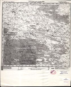
- Description:
- 1931
- Subject:
- Topical Subject: Soviet Union, Geographic Subject: Terekli-Mekteb, and Topical Subject: Maps
- Publisher:
- Генеральный штаб Красной Армии
- Language:
- Russian
- Date Created:
- 1942
- Identifier:
- VAC9619-002247
- Genre:
- Military Maps and Topographic Maps
- Geographic Location:
- Coordinates: 44, 45.5, 44.3333, 46
- Related URL:
- Download GeoTIFF: https://drive.google.com/file/d/19JNpI44e2BYE9Zig1yM5b4xvbT7XbCN-/view?usp=sharing and Catalog URL: https://iucat.iu.edu/catalog/5020129
- Abstract:
- Modern area represented: Terekli-Mekteb, Dagestan, Russia
- Call Number:
- G7000 s100 .S7 sheet L-38-140
- Caption:
- Для служебного пользования
- City:
- Терекли Мектеб (Terekli Mekteb)
- Copyright Holder:
- No Copyright - United States
- Country:
- СССР (USSR)
- State/Province:
- Орджоникидзевский край (Ordzhonikidze kray), Кизлярский округ (Kizlyar district), and РСФСР (RSFSR)
- Physical Description:
- Scale: 1:100,000
- Persistent URL:
- http://purl.dlib.indiana.edu/iudl/images/VAC9619/VAC9619-002247
- Provenance:
- CIA Map Library, Library of Congress Geography & Map Division
-
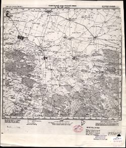
- Description:
- 1928
- Subject:
- Topical Subject: Soviet Union, Topical Subject: Maps, and Geographic Subject: Kayasula
- Publisher:
- Генеральный штаб Красной Армии
- Language:
- Russian
- Date Created:
- 1942
- Identifier:
- VAC9619-002246
- Genre:
- Topographic Maps and Military Maps
- Geographic Location:
- Coordinates: 44, 45, 44.3333, 45.5
- Related URL:
- Catalog URL: https://iucat.iu.edu/catalog/5020129 and Download GeoTIFF: https://drive.google.com/file/d/14F9oDcxiwzltI6-2j2gu5lCbVn5jPTnU/view?usp=sharing
- Abstract:
- Modern area represented: Kayasula, Stavropol kray, Russia
- Call Number:
- G7000 s100 .S7 sheet L-38-139
- Caption:
- Для служебного пользования
- City:
- Каясулу (Kayasulu)
- Copyright Holder:
- No Copyright - United States
- Country:
- СССР (USSR)
- State/Province:
- Орджоникидзевский край (Ordzhonikidze kray), РСФСР (RSFSR), and Кизлярский округ (Kizlyar district)
- Physical Description:
- Scale: 1:100,000
- Persistent URL:
- http://purl.dlib.indiana.edu/iudl/images/VAC9619/VAC9619-002246
- Provenance:
- CIA Map Library, Library of Congress Geography & Map Division
-
- Description:
- 1927
- Subject:
- Topical Subject: Soviet Union, Geographic Subject: Stepnoe, Geographic Subject: Stavropol' Krai, and Topical Subject: Maps
- Publisher:
- Генеральный штаб Красной Армии
- Language:
- Russian
- Date Created:
- 1942
- Identifier:
- VAC9619-002245
- Genre:
- Topographic Maps and Military Maps
- Geographic Location:
- Coordinates: 44, 44.5, 44.3333, 45
- Related URL:
- Catalog URL: https://iucat.iu.edu/catalog/5020129 and Download GeoTIFF: https://drive.google.com/file/d/1owpEknd01CfxB1AG5PAYsRllgjCo-Jte/view?usp=sharing
- Abstract:
- Modern area represented: Степное (Stepnoe), Stavropol' Krai, Russia
- Call Number:
- G7000 s100 .S7 sheet L-38-138
- Caption:
- Для cлужебного пользования
- City:
- Степное (Stepnoe)
- Copyright Holder:
- No Copyright - United States
- Country:
- СССР (USSR)
- State/Province:
- Орджоникидзевский край (Ordzhonikidze kray), Кизлярский округ (Kizlyar district), and РСФСР (RSFSR)
- Physical Description:
- Scale: 1:100,000
- Persistent URL:
- http://purl.dlib.indiana.edu/iudl/images/VAC9619/VAC9619-002245
- Provenance:
- DMA Topographic Center, Army Map Service Library
-
- Description:
- 1924
- Subject:
- Geographic Subject: Sovetskaya, Topical Subject: Maps, and Topical Subject: Soviet Union
- Publisher:
- Генеральный штаб Красной Армии
- Language:
- Russian
- Date Created:
- 1942
- Identifier:
- VAC9619-002244
- Genre:
- Military Maps and Topographic Maps
- Geographic Location:
- Coordinates: 44, 44, 44.3333, 44.5
- Related URL:
- Download GeoTIFF: https://drive.google.com/file/d/18AdxFsVZrIfpakSdWXLC-95qaAluwUbH/view?usp=sharing and Catalog URL: https://iucat.iu.edu/catalog/5020129
- Abstract:
- Modern area represented: Sovetskaya, Stavropol kray, Russia
- Call Number:
- G7000 s100 .S7 sheet L-38-137
- Caption:
- Для служебного пользования
- City:
- Советская (Sovetskaya)
- Copyright Holder:
- No Copyright - United States
- Country:
- СССР (USSR)
- State/Province:
- Орджоникидзевский край (Ordzhonikidze kray)
- Physical Description:
- Scale: 1:100,000
- Persistent URL:
- http://purl.dlib.indiana.edu/iudl/images/VAC9619/VAC9619-002244
- Provenance:
- CIA Map Library, Atlasblatt, Heeresplankammer Gruppe Archive Auslandskartenarchiv, Library of Congress Geography & Map Division
-
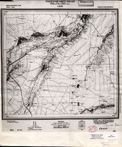
- Description:
- 1925
- Subject:
- Topical Subject: Soviet Union, Geographic Subject: Soldato-Aleksandrovskoye, and Topical Subject: Maps
- Publisher:
- Геодезический комитет ВСНХ-СССР
- Language:
- Russian
- Date Created:
- 1927
- Identifier:
- VAC9619-002243
- Genre:
- Topographic Maps and Military Maps
- Geographic Location:
- Coordinates: 44, 43.5, 44.3333, 44
- Related URL:
- Download GeoTIFF: https://drive.google.com/file/d/1rye3y2ZkwI92yxY3O2lqSvD95lhvDVrU/view?usp=sharing and Catalog URL: https://iucat.iu.edu/catalog/5020129
- Abstract:
- Modern area represented: Soldato-Aleksandrovskoye, Stavropol kray, Russia
- Call Number:
- G7000 s100 .S7 sheet L-38-136
- City:
- Солдатско-Александровское (Soldato-Aleksandrovskoye)
- Copyright Holder:
- No Copyright - United States
- Country:
- СССР (USSR)
- State/Province:
- Северо-Кавказский край (North Caucasus kray), РСФСР (RSFSR), and Терский округ (Tersky district)
- Physical Description:
- Scale: 1:100,000
- Persistent URL:
- http://purl.dlib.indiana.edu/iudl/images/VAC9619/VAC9619-002243
- Provenance:
- CIA Map Library, Heeresplankammer Auslandskartenarchiv, Library of Congress Geography & Map Division
-
- Description:
- 1909
- Subject:
- Geographic Subject: Stavropol’ Krai, Topical Subject: Maps, Topical Subject: Soviet Union, and Geographic Subject: Pyatigorsk
- Publisher:
- Управление военных топографов РККА
- Language:
- Russian
- Date Created:
- 1936
- Identifier:
- VAC9619-002242
- Genre:
- Military Maps and Topographic Maps
- Geographic Location:
- Coordinates: 44, 43, 44.3333, 43.5
- Related URL:
- Download GeoTIFF: https://drive.google.com/file/d/1b87g1ffiH5tUIIxMUlRAMC1SpRo9sRtq/view?usp=sharing and Catalog URL: https://iucat.iu.edu/catalog/5020129
- Abstract:
- Modern area represented: Пятигорск (Pyatigorsk), Stavropol’ Krai, Russia
- Call Number:
- G7000 s100 .S7 sheet L-38-135
- Caption:
- Для cлужебного пользования
- City:
- Пятигорск (Pyatigorsk)
- Copyright Holder:
- No Copyright - United States
- Country:
- СССР (USSR)
- State/Province:
- Орджоникидзевский край (Ordzhonikidze kray) and РСФСР (RSFSR)
- Physical Description:
- Scale: 1:100,000
- Persistent URL:
- http://purl.dlib.indiana.edu/iudl/images/VAC9619/VAC9619-002242
- Provenance:
- DMA Topographic Center, Army Map Service Library
-
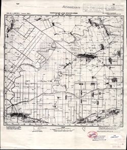
- Description:
- 1941
- Subject:
- Topical Subject: Soviet Union, Topical Subject: Maps, and Geographic Subject: Rostov
- Publisher:
- Генеральный штаб Красной Армии
- Language:
- Russian
- Identifier:
- VAC9619-002241
- Genre:
- Military Maps and Topographic Maps
- Geographic Location:
- Coordinates: 57, 39, 57.3333, 39.5
- Related URL:
- Catalog URL: https://iucat.iu.edu/catalog/5020129 and Download GeoTIFF: https://drive.google.com/file/d/1AW9oFgN-ZBuNRh7dVqwzdbfwU8kPeQsM/view?usp=sharing
- Abstract:
- Modern area represented: Rostov, Yaroslavl oblast, Russia
- Call Number:
- G7000 s100 .S7 sheet O-37-103
- Caption:
- Для служебного пользования,Captured map
- City:
- Ростов (Rostov)
- Copyright Holder:
- No Copyright - United States
- Country:
- СССР (USSR)
- State/Province:
- РСФСР (RSFSR) and Ярославская область (Yaroslavl oblast)
- Physical Description:
- Scale: 1:100,000
- Persistent URL:
- http://purl.dlib.indiana.edu/iudl/images/VAC9619/VAC9619-002241
- Provenance:
- DMA Topographic Center, Army Map Service Library, OMAHA, Library of Congress Geography & Map Division
-
- Subject:
- Geographic Subject: Kalyazin, Topical Subject: Soviet Union, and Topical Subject: Maps
- Publisher:
- Генеральный штаб Красной Армии
- Language:
- Russian
- Date Created:
- 1941
- Identifier:
- VAC9619-002240
- Genre:
- Military Maps and Topographic Maps
- Geographic Location:
- Coordinates: 57, 37.5, 57.3333, 38
- Related URL:
- Download GeoTIFF: https://drive.google.com/file/d/1W4tD9KPybJWJ3eX1HIuJOrPOTP7KNdqb/view?usp=sharing and Catalog URL: https://iucat.iu.edu/catalog/5020129
- Abstract:
- Modern area represented: Калязин (Kalyazin), Tverskaya oblast, Russia
- Call Number:
- G7000 s100 .S7 sheet O-37-100
- City:
- Калязин (Kalyazin)
- Copyright Holder:
- No Copyright - United States
- Country:
- СССР (USSR)
- State/Province:
- Калининская область (Kalinin oblast) and РСФСР (RSFSR)
- Physical Description:
- Scale: 1:100,000
- Persistent URL:
- http://purl.dlib.indiana.edu/iudl/images/VAC9619/VAC9619-002240
- Provenance:
- DMA Topographic Center, Army Map Service Library, OMAHA, Library of Congress Geography & Map Division
-
- Subject:
- Topical Subject: Soviet Union, Geographic Subject: Yaroslavl, and Topical Subject: Maps
- Publisher:
- Генеральный штаб Красной Армии
- Language:
- Russian
- Date Created:
- 1941
- Identifier:
- VAC9619-002239
- Genre:
- Topographic Maps and Military Maps
- Geographic Location:
- Coordinates: 57.3333, 39.5, 57.6667, 40
- Related URL:
- Catalog URL: https://iucat.iu.edu/catalog/5020129 and Download GeoTIFF: https://drive.google.com/file/d/1s1X2JX-UlHkHlKMosuECdWUBwvDsqFQ1/view?usp=sharing
- Abstract:
- Modern area represented: Yaroslavl, Yaroslavl oblast, Russia
- Call Number:
- G7000 s100 .S7 sheet O-37-92
- Caption:
- Для служебного пользования,Captured map
- City:
- Ярославль (Yaroslavl')
- Copyright Holder:
- No Copyright - United States
- Country:
- СССР (USSR)
- State/Province:
- Ярославская область (Yaroslavl oblast) and РСФСР (RSFSR)
- Physical Description:
- Scale: 1:100,000
- Persistent URL:
- http://purl.dlib.indiana.edu/iudl/images/VAC9619/VAC9619-002239
- Provenance:
- DMA Topographic Center, Army Map Service Library
