
Search Constraints
You searched for:
County
Marin
Remove constraint County: Marin
Subject
Mountains
Remove constraint Subject: Mountains
1 - 77 of 77
Search Results
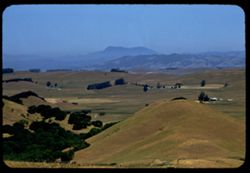
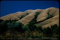
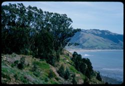
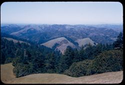
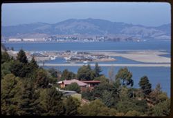
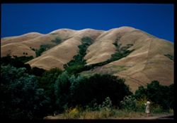
-
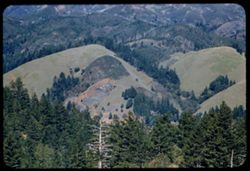
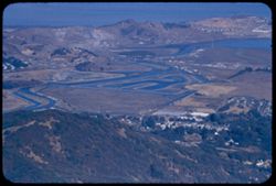
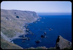
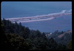
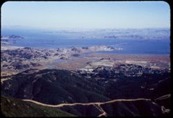
- Description:
- 100 f 6.3 tl
- Subject:
- Hills, Mountains, Tamalpais, Mount (Calif.), and Trees
- Series:
- 2-56
- Creator:
- Cushman, Charles W., 1896-1972
- Date Created:
- 1956-03-14
- Genre:
- Landscape photographs
- Frame Number:
- 2
- County:
- Marin
- Abstract:
- From road on West shoulder of Mt. Tamalpais: Folded hills to north
- Call Number:
- P08568
- Country:
- United States
- State/Province:
- California
- Alternate Identifier:
- 256.2
- Persistent URL:
- http://purl.dlib.indiana.edu/iudl/archives/cushman/P08568
- Holding Location:
- Bloomington - University Archives
Wells Library E460
1320 E 10th St.
Bloomington, IN 47405
Contact at archives@indiana.edu, 812-855-1127
-
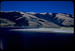
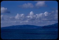
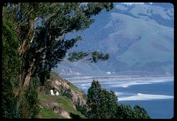
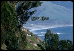
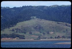
- Description:
- 25 f 8 Pola
- Subject:
- Lakes & ponds, Houses, Bodies of water, Sand, Mountains, Waterfronts, Trees, Beaches, Grasses, and Hills
- Series:
- 7-53
- Creator:
- Cushman, Charles W., 1896-1972
- Date Created:
- 1953-07-08
- Genre:
- Landscape photographs
- Frame Number:
- 29
- County:
- Marin
- Abstract:
- Across Bolinas lagoon from Bolinas.
- Call Number:
- P06753
- City:
- Bolinas
- Country:
- United States
- State/Province:
- California
- Alternate Identifier:
- 753.29
- Persistent URL:
- http://purl.dlib.indiana.edu/iudl/archives/cushman/P06753
- Holding Location:
- Bloomington - University Archives
Wells Library E460
1320 E 10th St.
Bloomington, IN 47405
Contact at archives@indiana.edu, 812-855-1127
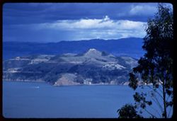
-
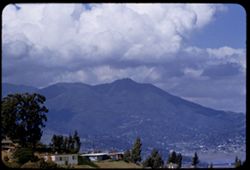
- Description:
- 100 f 5.6 tl
- Subject:
- Valleys, Hills, Bodies of water, Roads, Mountains, Tamalpais, Mount (Calif.), Trees, Buildings, Clouds, Dwellings, and Utility poles
- Series:
- 5-55
- Creator:
- Cushman, Charles W., 1896-1972
- Date Created:
- 1955-03-10
- Genre:
- Landscape photographs
- Frame Number:
- 4
- County:
- Marin
- Abstract:
- Cloud mass above Mt. Tamalpais from top of Sausalito All of frame will next to 3
- Call Number:
- P07669
- City:
- Sausalito
- Country:
- United States
- State/Province:
- California
- Alternate Identifier:
- 555.4
- Persistent URL:
- http://purl.dlib.indiana.edu/iudl/archives/cushman/P07669
- Holding Location:
- Bloomington - University Archives
Wells Library E460
1320 E 10th St.
Bloomington, IN 47405
Contact at archives@indiana.edu, 812-855-1127
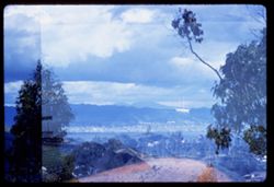
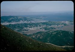
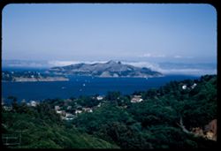
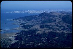
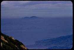
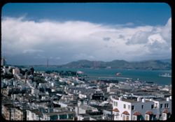
-
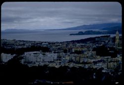
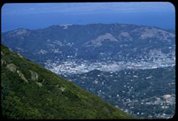
- Description:
- 100 f 5 tl wrong focus error at 300 ft.
- Subject:
- Domes, Cities & towns, Streets, Hills, Bodies of water, Mountains, Dwellings, Buena Vista Park (San Francisco, Calif.), Buildings, Coastlines, Clouds, Tr...
- Series:
- 5-55
- Creator:
- Cushman, Charles W., 1896-1972
- Date Created:
- 1955-03-12
- Genre:
- Cityscape photographs
- Frame Number:
- 20
- County:
- Marin and San Francisco
- Abstract:
- Toward Pt. Reyes under clouds were out too far to left and had to be remounted
- Call Number:
- P07685
- City:
- San Francisco and Point Reyes Station
- Country:
- United States
- State/Province:
- California
- Alternate Identifier:
- 555.20
- Persistent URL:
- http://purl.dlib.indiana.edu/iudl/archives/cushman/P07685
- Holding Location:
- Bloomington - University Archives
Wells Library E460
1320 E 10th St.
Bloomington, IN 47405
Contact at archives@indiana.edu, 812-855-1127
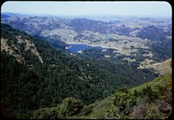
-
- Description:
- 100 f 6.3
- Subject:
- Novato Creek Dam (Calif.), Little Mountain (Marin County, Calif.), Hills, Mountains, Reservoirs, and Meadows
- Series:
- 4-57
- Creator:
- Cushman, Charles W., 1896-1972
- Date Created:
- 1957-04-25
- Genre:
- Landscape photographs
- Frame Number:
- 17
- County:
- Marin
- Abstract:
- Green Hill above Novato Dam (Little Mtn.)
- Call Number:
- P09201
- Country:
- United States
- State/Province:
- California
- Alternate Identifier:
- 457.17
- Persistent URL:
- http://purl.dlib.indiana.edu/iudl/archives/cushman/P09201
- Holding Location:
- Bloomington - University Archives
Wells Library E460
1320 E 10th St.
Bloomington, IN 47405
Contact at archives@indiana.edu, 812-855-1127
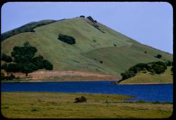
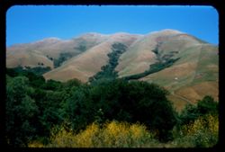
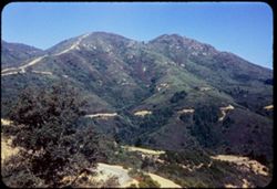
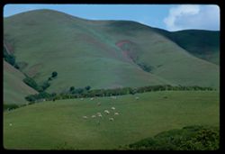
-
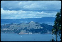
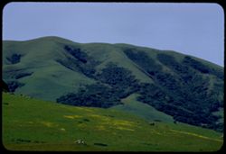
- Description:
- 100 f 11 SL
- Subject:
- Meadows, Black Mountain (Marin County, Calif.), Hills, Mountains, Trees, Grazing, and Clouds
- Series:
- 1-63
- Creator:
- Cushman, Charles W., 1896-1972
- Date Created:
- 1963-04-09
- Genre:
- Landscape photographs
- Frame Number:
- 12
- County:
- Marin
- Abstract:
- Black Mtn-
- Call Number:
- P12816
- City:
- Point Reyes Station
- Country:
- United States
- State/Province:
- California
- Alternate Identifier:
- 163.12
- Persistent URL:
- http://purl.dlib.indiana.edu/iudl/archives/cushman/P12816
- Holding Location:
- Bloomington - University Archives
Wells Library E460
1320 E 10th St.
Bloomington, IN 47405
Contact at archives@indiana.edu, 812-855-1127
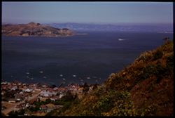
-
- Description:
- 100 f 5.6 tl
- Subject:
- Cities & towns, Storage tanks, Hills, Bodies of water, Birds, Mountains, Utility poles, Trees, Piers & wharves, Coastlines, Boats, and Dwellings
- Series:
- 5-55
- Creator:
- Cushman, Charles W., 1896-1972
- Date Created:
- 1955-03-10
- Genre:
- Marine photographs
- Frame Number:
- 18
- County:
- Marin
- Abstract:
- South point of Tiburon Has strip of .7 but is correct at it
- Call Number:
- P07683
- City:
- Tiburon
- Country:
- United States
- State/Province:
- California
- Alternate Identifier:
- 555.18
- Persistent URL:
- http://purl.dlib.indiana.edu/iudl/archives/cushman/P07683
- Holding Location:
- Bloomington - University Archives
Wells Library E460
1320 E 10th St.
Bloomington, IN 47405
Contact at archives@indiana.edu, 812-855-1127
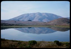
-
- Description:
- 100 f 11
- Subject:
- Lakes & ponds, Black Mountain (Marin County, Calif.), Hills, Mountains, Coastlines, Clouds, and Grasses
- Series:
- 27-65
- Creator:
- Cushman, Charles W., 1896-1972
- Date Created:
- 1965-07-26
- Genre:
- Landscape photographs
- Frame Number:
- 1
- County:
- Marin
- Abstract:
- Hopi Pt. and Black Mtn. Western Marin
- Call Number:
- P14800
- Country:
- United States
- State/Province:
- California
- Alternate Identifier:
- 2765.1
- Persistent URL:
- http://purl.dlib.indiana.edu/iudl/archives/cushman/P14800
- Holding Location:
- Bloomington - University Archives
Wells Library E460
1320 E 10th St.
Bloomington, IN 47405
Contact at archives@indiana.edu, 812-855-1127
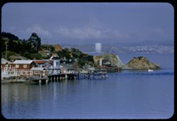
-
- Description:
- 100 f 6.3 TL
- Subject:
- Bays (Bodies of water), Waldo Height, Boats, Waldo Point Harbor (Calif.), Tree limbs, Mountains, Richardson Bay (Calif.), and Trees
- Series:
- 1-60
- Creator:
- Cushman, Charles W., 1896-1972
- Date Created:
- 1960-02-18
- Genre:
- Cityscape photographs
- Frame Number:
- 28
- County:
- Marin
- Abstract:
- Double exposure
- Call Number:
- P10921
- City:
- Sausalito
- Country:
- United States
- State/Province:
- California
- Alternate Identifier:
- 160.28
- Persistent URL:
- http://purl.dlib.indiana.edu/iudl/archives/cushman/P10921
- Holding Location:
- Bloomington - University Archives
Wells Library E460
1320 E 10th St.
Bloomington, IN 47405
Contact at archives@indiana.edu, 812-855-1127
-
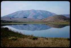
- Description:
- 100 f 9
- Subject:
- Grasses, Coastlines, Mountains, Lakes & ponds, Hills, and Reflections
- Series:
- 5-67
- Creator:
- Cushman, Charles W., 1896-1972
- Date Created:
- 1967-10-24
- Genre:
- Landscape photographs
- Frame Number:
- 18
- County:
- Marin
- Abstract:
- Black Mtn at hazy noon
- Call Number:
- P15593
- City:
- Point Reyes Station
- Country:
- United States
- State/Province:
- California
- Alternate Identifier:
- 567.18
- Persistent URL:
- http://purl.dlib.indiana.edu/iudl/archives/cushman/P15593
- Holding Location:
- Bloomington - University Archives
Wells Library E460
1320 E 10th St.
Bloomington, IN 47405
Contact at archives@indiana.edu, 812-855-1127
-
- Description:
- 50 f 9
- Subject:
- Trees, Flowers, Flowering shrubs, Mountains, Shrubs, Black Mountain (Marin County, Calif.), and Hills
- Series:
- 2-54
- Creator:
- Cushman, Charles W., 1896-1972
- Date Created:
- 1954-05-21
- Genre:
- Landscape photographs
- Frame Number:
- 6
- Street Address:
- Lagunitas Road
- County:
- Marin
- Abstract:
- Black Mtn. Again from Lagunitas Rd. - sw. -
- Call Number:
- P07137
- Country:
- United States
- State/Province:
- California
- Alternate Identifier:
- 254.6
- Persistent URL:
- http://purl.dlib.indiana.edu/iudl/archives/cushman/P07137
- Holding Location:
- Bloomington - University Archives
Wells Library E460
1320 E 10th St.
Bloomington, IN 47405
Contact at archives@indiana.edu, 812-855-1127
-
- Description:
- 100 f 6.3 TL
- Subject:
- Bays (Bodies of water), Waldo Height, Roads, Angel Island (Calif.), Waldo Point Harbor (Calif.), Mountains, Richardson Bay (Calif.), Clouds, Islands, and Hills
- Series:
- 1-60
- Creator:
- Cushman, Charles W., 1896-1972
- Date Created:
- 1960-02-18
- Genre:
- Landscape photographs
- Frame Number:
- 32
- County:
- Marin
- Abstract:
- Top of Angel Island
- Call Number:
- P10925
- City:
- Sausalito
- Country:
- United States
- State/Province:
- California
- Alternate Identifier:
- 160.32
- Persistent URL:
- http://purl.dlib.indiana.edu/iudl/archives/cushman/P10925
- Holding Location:
- Bloomington - University Archives
Wells Library E460
1320 E 10th St.
Bloomington, IN 47405
Contact at archives@indiana.edu, 812-855-1127
-
- Description:
- 100 f 8 tl
- Subject:
- Valleys, Houses, Farms, Trees, Saint Helena, Mount (Calif.), Mountains, Fences, Hills, and Mists
- Series:
- 7-56
- Creator:
- Cushman, Charles W., 1896-1972
- Date Created:
- 1956-06-09
- Genre:
- Landscape photographs
- Frame Number:
- 23
- Street Address:
- Marshall Petaluma Road
- County:
- Marin and Sonoma
- Abstract:
- From Marshall Petaluma road high point, northeastward across Sonoma valleys toward Mt St. Helena
- Call Number:
- P08770
- Country:
- United States
- State/Province:
- California
- Alternate Identifier:
- 756.23
- Persistent URL:
- http://purl.dlib.indiana.edu/iudl/archives/cushman/P08770
- Holding Location:
- Bloomington - University Archives
Wells Library E460
1320 E 10th St.
Bloomington, IN 47405
Contact at archives@indiana.edu, 812-855-1127
-
- Description:
- 100 f 8 tl
- Subject:
- Oceans, Lands End (Calif.), Coastlines, Pacific Ocean, Mountains, Pacific Coast (Calif.), Waterfronts, and Clouds
- Series:
- 1-57
- Creator:
- Cushman, Charles W., 1896-1972
- Date Created:
- 1957-03-16
- Genre:
- Seascapes
- Frame Number:
- 13
- County:
- Marin and San Francisco
- Abstract:
- Toward Bolinas
- Call Number:
- P09119
- City:
- Bolinas and San Francisco
- Country:
- United States
- State/Province:
- California
- Alternate Identifier:
- 157.13
- Persistent URL:
- http://purl.dlib.indiana.edu/iudl/archives/cushman/P09119
- Holding Location:
- Bloomington - University Archives
Wells Library E460
1320 E 10th St.
Bloomington, IN 47405
Contact at archives@indiana.edu, 812-855-1127
-
- Description:
- 50 f 8
- Subject:
- Bays (Bodies of water), Seas, Sand, Trees, Coastlines, Bolinas Bay (Calif.), Mountains, Beaches, Shrubs, Lakes & ponds, Dwellings, Stinson Beach (Calif.)...
- Series:
- 4-54
- Creator:
- Cushman, Charles W., 1896-1972
- Date Created:
- 1954-07-29
- Genre:
- Landscape photographs
- Frame Number:
- 11
- County:
- Marin
- Abstract:
- Bolinas Bay from [ct] south
- Call Number:
- P07185
- City:
- Bolinas
- Country:
- United States
- State/Province:
- California
- Physical Description:
- Anscochrome film.
- Alternate Identifier:
- 454.11
- Persistent URL:
- http://purl.dlib.indiana.edu/iudl/archives/cushman/P07185
- Holding Location:
- Bloomington - University Archives
Wells Library E460
1320 E 10th St.
Bloomington, IN 47405
Contact at archives@indiana.edu, 812-855-1127
-
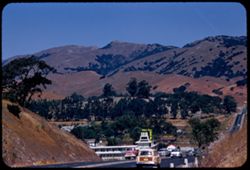
- Description:
- 100 f 8 tl
- Subject:
- Roads, Automobiles, Santa Venetia Junction, Signs (Notices), Mountains, Hills, Trees, and Motels
- Series:
- 12-56
- Creator:
- Cushman, Charles W., 1896-1972
- Date Created:
- 1956-08-14
- Frame Number:
- 19
- Street Address:
- United States Highway 101
- County:
- Marin
- Abstract:
- View north along US 101 from Santa Venetia Junction
- Call Number:
- P08954
- City:
- San Rafael and Santa Venetia
- Country:
- United States
- State/Province:
- California
- Alternate Identifier:
- 1256.19
- Persistent URL:
- http://purl.dlib.indiana.edu/iudl/archives/cushman/P08954
- Holding Location:
- Bloomington - University Archives
Wells Library E460
1320 E 10th St.
Bloomington, IN 47405
Contact at archives@indiana.edu, 812-855-1127
-
- Description:
- 100 f 11
- Subject:
- Rocks, Grasses, Coastlines, Mountains, Lakes & ponds, Clouds, Black Mountain (Marin County, Calif.), and Hills
- Series:
- 27-65
- Creator:
- Cushman, Charles W., 1896-1972
- Date Created:
- 1965-07-26
- Genre:
- Landscape photographs
- Frame Number:
- 2
- County:
- Marin
- Abstract:
- Hopi Pt. and Black Mtn. Western Marin
- Call Number:
- P14801
- City:
- Nicasio
- Country:
- United States
- State/Province:
- California
- Alternate Identifier:
- 2765.2
- Persistent URL:
- http://purl.dlib.indiana.edu/iudl/archives/cushman/P14801
- Holding Location:
- Bloomington - University Archives
Wells Library E460
1320 E 10th St.
Bloomington, IN 47405
Contact at archives@indiana.edu, 812-855-1127
-
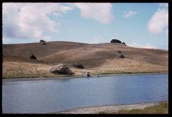
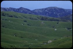
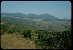
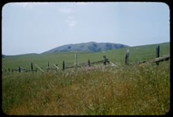
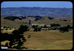
- Description:
- 50 f 8
- Subject:
- Rocks, Grasses, Salmon Creek (Marin County, Calif.), Farms, Meadows, Mountains, Fences, Hills, and Grazing
- Series:
- 1-54
- Creator:
- Cushman, Charles W., 1896-1972
- Date Created:
- 1954-02-21
- Genre:
- Landscape photographs
- Frame Number:
- 2
- County:
- Marin
- Abstract:
- Marin county - a rolling pasture land & mountain background along
- Call Number:
- P07112
- Country:
- United States
- State/Province:
- California
- Alternate Identifier:
- 154.2
- Persistent URL:
- http://purl.dlib.indiana.edu/iudl/archives/cushman/P07112
- Holding Location:
- Bloomington - University Archives
Wells Library E460
1320 E 10th St.
Bloomington, IN 47405
Contact at archives@indiana.edu, 812-855-1127
-
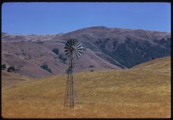
- Description:
- 100 f 6.3 TL
- Subject:
- Windmills, Meadows, Mountains, and Hills
- Series:
- 13-58
- Creator:
- Cushman, Charles W., 1896-1972
- Date Created:
- 1958-07-18
- Genre:
- Landscape photographs
- Frame Number:
- 15
- County:
- Marin
- Abstract:
- Marin ridge back of wind mill (8808.8 mi.)
- Call Number:
- P10063
- City:
- Nicasio
- Country:
- United States
- State/Province:
- California
- Alternate Identifier:
- 1358.15
- Persistent URL:
- http://purl.dlib.indiana.edu/iudl/archives/cushman/P10063
- Holding Location:
- Bloomington - University Archives
Wells Library E460
1320 E 10th St.
Bloomington, IN 47405
Contact at archives@indiana.edu, 812-855-1127
-
- Description:
- 100 f 5.6 tl
- Subject:
- Bays (Bodies of water), Angel Island (Calif.), Trees, Mountains, Islands, Tamalpais, Mount (Calif.), Hills, and Cities & towns
- Series:
- 29-55
- Creator:
- Cushman, Charles W., 1896-1972
- Date Created:
- 1955-10-31
- Genre:
- Landscape photographs and Cityscape photographs
- Frame Number:
- 12
- County:
- Marin
- Abstract:
- Toward Angel Island & Belvidere
- Call Number:
- P08503
- City:
- Belvedere
- Country:
- United States
- State/Province:
- California
- Alternate Identifier:
- 2955.12
- Persistent URL:
- http://purl.dlib.indiana.edu/iudl/archives/cushman/P08503
- Holding Location:
- Bloomington - University Archives
Wells Library E460
1320 E 10th St.
Bloomington, IN 47405
Contact at archives@indiana.edu, 812-855-1127
-
- Description:
- 50 f 6.3 Pola
- Subject:
- Wildflowers, Grasses, Trees, Tomales Bay (Calif.), Mountains, and Black Mountain (Marin County, Calif.)
- Series:
- 7-53
- Creator:
- Cushman, Charles W., 1896-1972
- Date Created:
- 1953-06-17
- Genre:
- Landscape photographs
- Frame Number:
- 10
- County:
- Marin
- Abstract:
- Black Mtn. - Marin county near Point Reyes Station
- Call Number:
- P06735
- City:
- Point Reyes Station
- Country:
- United States
- State/Province:
- California
- Alternate Identifier:
- 753.10
- Persistent URL:
- http://purl.dlib.indiana.edu/iudl/archives/cushman/P06735
- Holding Location:
- Bloomington - University Archives
Wells Library E460
1320 E 10th St.
Bloomington, IN 47405
Contact at archives@indiana.edu, 812-855-1127
-
- Description:
- 100 f 8 tl
- Subject:
- Bays (Bodies of water), Oceans, Seas, Cliffs, Trees, Coastlines, Bolinas Bay (Calif.), Tree limbs, Mountains, Beaches, Hills, and People
- Series:
- 1-68
- Creator:
- Cushman, Charles W., 1896-1972
- Date Created:
- 1968-03-02
- Genre:
- Landscape photographs and Seascapes
- Frame Number:
- 18
- County:
- Marin
- Abstract:
- at Bolinas
- Call Number:
- P15613
- City:
- Bolinas
- Country:
- United States
- State/Province:
- California
- Alternate Identifier:
- 168.18
- Persistent URL:
- http://purl.dlib.indiana.edu/iudl/archives/cushman/P15613
- Holding Location:
- Bloomington - University Archives
Wells Library E460
1320 E 10th St.
Bloomington, IN 47405
Contact at archives@indiana.edu, 812-855-1127
-
- Description:
- 100 f 8 tl
- Subject:
- Bays (Bodies of water), Oceans, Seas, Cliffs, Trees, Coastlines, Bolinas Bay (Calif.), Tree limbs, Mountains, Beaches, Hills, and People
- Series:
- 1-68
- Creator:
- Cushman, Charles W., 1896-1972
- Date Created:
- 1968-03-02
- Genre:
- Landscape photographs and Seascapes
- Frame Number:
- 16
- County:
- Marin
- Abstract:
- at Bolinas
- Call Number:
- P15611
- City:
- Bolinas
- Country:
- United States
- State/Province:
- California
- Alternate Identifier:
- 168.16
- Persistent URL:
- http://purl.dlib.indiana.edu/iudl/archives/cushman/P15611
- Holding Location:
- Bloomington - University Archives
Wells Library E460
1320 E 10th St.
Bloomington, IN 47405
Contact at archives@indiana.edu, 812-855-1127
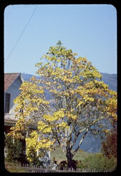
-
- Description:
- 100 f 8 tl
- Subject:
- Evergreens, Trees, Flowers, Acacia, Mountains, and Hills
- Series:
- 1-68
- Creator:
- Cushman, Charles W., 1896-1972
- Date Created:
- 1968-03-02
- Genre:
- Landscape photographs
- Frame Number:
- 19
- County:
- Marin
- Abstract:
- Acacia & Evergreen at Tocaloma
- Call Number:
- P15614
- City:
- Tocaloma
- Country:
- United States
- State/Province:
- California
- Alternate Identifier:
- 168.19
- Persistent URL:
- http://purl.dlib.indiana.edu/iudl/archives/cushman/P15614
- Holding Location:
- Bloomington - University Archives
Wells Library E460
1320 E 10th St.
Bloomington, IN 47405
Contact at archives@indiana.edu, 812-855-1127
-
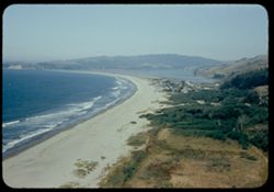
- Description:
- 100 f 8
- Subject:
- Bays (Bodies of water), Grasses, Cliffs, Trees, Coastlines, Bolinas Bay (Calif.), Mountains, Beaches, Shrubs, and Hills
- Series:
- 1-68
- Creator:
- Cushman, Charles W., 1896-1972
- Date Created:
- 1968-03-20
- Genre:
- Landscape photographs and Seascapes
- Frame Number:
- 29
- County:
- Marin
- Abstract:
- Across Bolinas Bay
- Call Number:
- P15623
- City:
- Bolinas
- Country:
- United States
- State/Province:
- California
- Alternate Identifier:
- 168.29
- Persistent URL:
- http://purl.dlib.indiana.edu/iudl/archives/cushman/P15623
- Holding Location:
- Bloomington - University Archives
Wells Library E460
1320 E 10th St.
Bloomington, IN 47405
Contact at archives@indiana.edu, 812-855-1127
-
- Description:
- 50 f 8
- Subject:
- Wildflowers, Bays (Bodies of water), Richardson Bay Bridge (Calif.), Grasses, Trees, Mountains, Richardson Bay (Calif.), Shrubs, Tamalpais, Mount (Calif.), H...
- Series:
- 4-54
- Creator:
- Cushman, Charles W., 1896-1972
- Date Created:
- 1954-08-13
- Genre:
- Cityscape photographs
- Frame Number:
- 14
- Street Address:
- United States Highway 101
- County:
- Marin
- Abstract:
- Mt. Tamalpais from US101- Richardson Bay bridge
- Call Number:
- P07188
- Country:
- United States
- State/Province:
- California
- Physical Description:
- Anscochrome film.
- Alternate Identifier:
- 454.14
- Persistent URL:
- http://purl.dlib.indiana.edu/iudl/archives/cushman/P07188
- Holding Location:
- Bloomington - University Archives
Wells Library E460
1320 E 10th St.
Bloomington, IN 47405
Contact at archives@indiana.edu, 812-855-1127
-
- Description:
- 100 f 6.3 tl
- Subject:
- Valleys, Meadows, Mountains, and Hills
- Series:
- 4-57
- Creator:
- Cushman, Charles W., 1896-1972
- Date Created:
- 1957-04-25
- Genre:
- Landscape photographs
- Frame Number:
- 12
- Street Address:
- Petaluma Marshall Road
- County:
- Marin and Sonoma
- Abstract:
- Greens of Marin hills & valley from Marshall Petaluma Rd.
- Call Number:
- P09196
- City:
- Petaluma and Marshall
- Country:
- United States
- State/Province:
- California
- Alternate Identifier:
- 457.12
- Persistent URL:
- http://purl.dlib.indiana.edu/iudl/archives/cushman/P09196
- Holding Location:
- Bloomington - University Archives
Wells Library E460
1320 E 10th St.
Bloomington, IN 47405
Contact at archives@indiana.edu, 812-855-1127
-
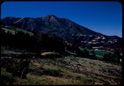
- Description:
- 50 f 8
- Subject:
- Trails & paths, Trees, Mountains, Shrubs, and Tamalpais, Mount (Calif.)
- Series:
- 16-54
- Creator:
- Cushman, Charles W., 1896-1972
- Date Created:
- 1954-10-23
- Genre:
- Landscape photographs
- Frame Number:
- 1
- County:
- Marin
- Abstract:
- Mt Tamalpais from SSW.
- Call Number:
- P07500
- Country:
- United States
- State/Province:
- California
- Physical Description:
- Anscochrome film.
- Alternate Identifier:
- 1654.1
- Persistent URL:
- http://purl.dlib.indiana.edu/iudl/archives/cushman/P07500
- Holding Location:
- Bloomington - University Archives
Wells Library E460
1320 E 10th St.
Bloomington, IN 47405
Contact at archives@indiana.edu, 812-855-1127
-
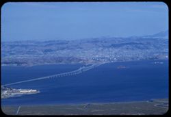
- Description:
- 100 f 6.3 tl
- Subject:
- Bays (Bodies of water), Richmond-San Rafael Bridge (Calif.), Mountains, Bridges, Tamalpais, Mount (Calif.), San Francisco Bay (Calif.), and Cities & towns
- Series:
- 15-57
- Creator:
- Cushman, Charles W., 1896-1972
- Date Created:
- 1957-10-03
- Genre:
- Views and Cityscape photographs
- Frame Number:
- 31
- County:
- Marin
- Abstract:
- Richmond - San Rafael Bridge
- Call Number:
- P09561
- Country:
- United States
- State/Province:
- California
- Alternate Identifier:
- 1557.31
- Persistent URL:
- http://purl.dlib.indiana.edu/iudl/archives/cushman/P09561
- Holding Location:
- Bloomington - University Archives
Wells Library E460
1320 E 10th St.
Bloomington, IN 47405
Contact at archives@indiana.edu, 812-855-1127
-
- Description:
- 50 f 9
- Subject:
- Grasses, Grazing, Trees, Meadows, Mountains, Fences, Shrubs, and Tamalpais, Mount (Calif.)
- Series:
- 4-54
- Creator:
- Cushman, Charles W., 1896-1972
- Date Created:
- 1954-07-29
- Genre:
- Landscape photographs
- Frame Number:
- 10
- County:
- Marin
- Abstract:
- Tamalpais from SW.
- Call Number:
- P07184
- Country:
- United States
- State/Province:
- California
- Physical Description:
- Anscochrome film.
- Alternate Identifier:
- 454.10
- Persistent URL:
- http://purl.dlib.indiana.edu/iudl/archives/cushman/P07184
- Holding Location:
- Bloomington - University Archives
Wells Library E460
1320 E 10th St.
Bloomington, IN 47405
Contact at archives@indiana.edu, 812-855-1127
-
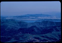
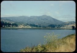
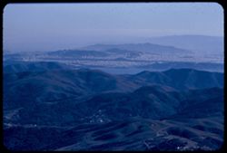
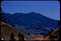
- Description:
- 100 f 8 tl
- Subject:
- Bays (Bodies of water), San Bruno Mountain (Calif.), Roads, Trees, Cities & towns, Tamalpais, Mount (Calif.), Hills, and Mountains
- Series:
- 2-56
- Creator:
- Cushman, Charles W., 1896-1972
- Date Created:
- 1956-03-14
- Genre:
- Landscape photographs and Cityscape photographs
- Frame Number:
- 13
- County:
- Marin and San Francisco
- Abstract:
- Toward Mt. San Bruno
- Call Number:
- P08579
- City:
- San Francisco
- Country:
- United States
- State/Province:
- California
- Alternate Identifier:
- 256.13
- Persistent URL:
- http://purl.dlib.indiana.edu/iudl/archives/cushman/P08579
- Holding Location:
- Bloomington - University Archives
Wells Library E460
1320 E 10th St.
Bloomington, IN 47405
Contact at archives@indiana.edu, 812-855-1127
-
- Description:
- 25 f 6.3 Pola
- Subject:
- Wildflowers, Grasses, Roads, Trees, Mountains, Shrubs, Tamalpais, Mount (Calif.), Utility poles, and Houses
- Series:
- 12-52
- Creator:
- Cushman, Charles W., 1896-1972
- Date Created:
- 1952-03-30
- Genre:
- Landscape photographs
- Frame Number:
- 15
- County:
- Marin
- Abstract:
- Mt. Tamalpais from road above Mill Valley.
- Call Number:
- P05922
- City:
- Mill Valley
- Country:
- United States
- State/Province:
- California
- Alternate Identifier:
- 1252.15
- Persistent URL:
- http://purl.dlib.indiana.edu/iudl/archives/cushman/P05922
- Holding Location:
- Bloomington - University Archives
Wells Library E460
1320 E 10th St.
Bloomington, IN 47405
Contact at archives@indiana.edu, 812-855-1127
-
- Description:
- 100 f 6.3 tl
- Subject:
- Oceans, Houses, Trees, Pacific Ocean, Mountains, and Tamalpais, Mount (Calif.)
- Series:
- 28-55
- Creator:
- Cushman, Charles W., 1896-1972
- Date Created:
- 1955-10-12
- Genre:
- Landscape photographs
- Frame Number:
- 21
- County:
- Marin
- Abstract:
- View down (E) from Tamalpais
- Call Number:
- P08476
- Country:
- United States
- State/Province:
- California
- Alternate Identifier:
- 2855.21
- Persistent URL:
- http://purl.dlib.indiana.edu/iudl/archives/cushman/P08476
- Holding Location:
- Bloomington - University Archives
Wells Library E460
1320 E 10th St.
Bloomington, IN 47405
Contact at archives@indiana.edu, 812-855-1127
-
- Description:
- 100 f 6.3 TL
- Subject:
- Waldo Height, Roads, Angel Island (Calif.), Trees, Waldo Point Harbor (Calif.), Mountains, Richardson Bay (Calif.), Clouds, Islands, and Hills
- Series:
- 1-60
- Creator:
- Cushman, Charles W., 1896-1972
- Date Created:
- 1960-02-18
- Genre:
- Landscape photographs
- Frame Number:
- 29
- County:
- Marin
- Abstract:
- Angel Island from ht above Sausalito
- Call Number:
- P10922
- City:
- Sausalito
- Country:
- United States
- State/Province:
- California
- Alternate Identifier:
- 160.29
- Persistent URL:
- http://purl.dlib.indiana.edu/iudl/archives/cushman/P10922
- Holding Location:
- Bloomington - University Archives
Wells Library E460
1320 E 10th St.
Bloomington, IN 47405
Contact at archives@indiana.edu, 812-855-1127
-
- Description:
- 25 f 8 Pola
- Subject:
- Bays (Bodies of water), Roads, Mountains, Tamalpais, Mount (Calif.), Hills, and San Francisco Bay (Calif.)
- Series:
- 12-52
- Creator:
- Cushman, Charles W., 1896-1972
- Date Created:
- 1952-03-30
- Genre:
- Landscape photographs and Cityscape photographs
- Frame Number:
- 23
- County:
- Marin
- Abstract:
- View N by E over San Rafael.
- Call Number:
- P05930
- City:
- San Rafael
- Country:
- United States
- State/Province:
- California
- Alternate Identifier:
- 1252.23
- Persistent URL:
- http://purl.dlib.indiana.edu/iudl/archives/cushman/P05930
- Holding Location:
- Bloomington - University Archives
Wells Library E460
1320 E 10th St.
Bloomington, IN 47405
Contact at archives@indiana.edu, 812-855-1127
-
- Description:
- 50 f 9
- Subject:
- Valleys, Trees, Mountains, Shrubs, Lakes & ponds, and Tamalpais, Mount (Calif.)
- Series:
- 16-54
- Creator:
- Cushman, Charles W., 1896-1972
- Date Created:
- 1954-10-23
- Genre:
- Landscape photographs
- Frame Number:
- 2
- County:
- Marin
- Abstract:
- View NNW from top of Tamalpais.
- Call Number:
- P07501
- Country:
- United States
- State/Province:
- California
- Physical Description:
- Anscochrome film.
- Alternate Identifier:
- 1654.2
- Persistent URL:
- http://purl.dlib.indiana.edu/iudl/archives/cushman/P07501
- Holding Location:
- Bloomington - University Archives
Wells Library E460
1320 E 10th St.
Bloomington, IN 47405
Contact at archives@indiana.edu, 812-855-1127
-
- Description:
- 25 f 6.3 Pola
- Subject:
- Bays (Bodies of water), Roads, Angel Island (Calif.), Fog, Trees, Mountains, Islands, Hills, North Bay (Humboldt County, Calif.), San Francisco Bay (Calif.),...
- Series:
- 8-53
- Creator:
- Cushman, Charles W., 1896-1972
- Date Created:
- 1953-08-30
- Genre:
- Landscape photographs
- Frame Number:
- 8
- County:
- Marin
- Abstract:
- Looking down on Angel Island from heights above Sausalito with fog over North Bay.
- Call Number:
- P06770
- City:
- Sausalito
- Country:
- United States
- State/Province:
- California
- Alternate Identifier:
- 853.8
- Persistent URL:
- http://purl.dlib.indiana.edu/iudl/archives/cushman/P06770
- Holding Location:
- Bloomington - University Archives
Wells Library E460
1320 E 10th St.
Bloomington, IN 47405
Contact at archives@indiana.edu, 812-855-1127
-
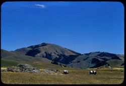
- Description:
- 100 f 9 TL
- Subject:
- Grazing, Trees, Meadows, Mountains, Fences, Black Mountain (Marin County, Calif.), and Animals
- Series:
- 1-63
- Creator:
- Cushman, Charles W., 1896-1972
- Date Created:
- 1963-04-09
- Genre:
- Landscape photographs
- Frame Number:
- 13
- County:
- Marin
- Abstract:
- Black Mtn
- Call Number:
- P12817
- Country:
- United States
- State/Province:
- California
- Alternate Identifier:
- 163.13
- Persistent URL:
- http://purl.dlib.indiana.edu/iudl/archives/cushman/P12817
- Holding Location:
- Bloomington - University Archives
Wells Library E460
1320 E 10th St.
Bloomington, IN 47405
Contact at archives@indiana.edu, 812-855-1127
-
- Description:
- 100 f 6 tl
- Subject:
- Valleys, Roads, Trees, Mountains, Buildings, Clouds, Tamalpais, Mount (Calif.), Hills, Utility poles, Fences, and Dwellings
- Series:
- 5-55
- Creator:
- Cushman, Charles W., 1896-1972
- Date Created:
- 1955-03-10
- Genre:
- Landscape photographs
- Frame Number:
- 3
- County:
- Marin
- Abstract:
- Cloud mass above Mt. Tamalpais from top of Sausalito
- Call Number:
- P07668
- City:
- Sausalito
- Country:
- United States
- State/Province:
- California
- Alternate Identifier:
- 555.3
- Persistent URL:
- http://purl.dlib.indiana.edu/iudl/archives/cushman/P07668
- Holding Location:
- Bloomington - University Archives
Wells Library E460
1320 E 10th St.
Bloomington, IN 47405
Contact at archives@indiana.edu, 812-855-1127
-
- Description:
- 100 f 8
- Subject:
- Grasses, Coastlines, Mountains, Lakes & ponds, Hills, and Reflections
- Series:
- 5-67
- Creator:
- Cushman, Charles W., 1896-1972
- Date Created:
- 1967-10-24
- Genre:
- Landscape photographs
- Frame Number:
- 19
- County:
- Marin
- Abstract:
- Black Mtn at hazy noon
- Call Number:
- P15594
- City:
- Point Reyes Station
- Country:
- United States
- State/Province:
- California
- Alternate Identifier:
- 567.19
- Persistent URL:
- http://purl.dlib.indiana.edu/iudl/archives/cushman/P15594
- Holding Location:
- Bloomington - University Archives
Wells Library E460
1320 E 10th St.
Bloomington, IN 47405
Contact at archives@indiana.edu, 812-855-1127
-
- Description:
- 50 f 8 sl
- Subject:
- Trees, Mountains, Tamalpais, Mount (Calif.), and Hills
- Series:
- 2-56
- Creator:
- Cushman, Charles W., 1896-1972
- Date Created:
- 1956-03-14
- Genre:
- Landscape photographs
- Frame Number:
- 9
- County:
- Marin
- Abstract:
- View north eastward from west shoulder of Mt Tamalpais
- Call Number:
- P08575
- Country:
- United States
- State/Province:
- California
- Alternate Identifier:
- 256.9
- Persistent URL:
- http://purl.dlib.indiana.edu/iudl/archives/cushman/P08575
- Holding Location:
- Bloomington - University Archives
Wells Library E460
1320 E 10th St.
Bloomington, IN 47405
Contact at archives@indiana.edu, 812-855-1127
-
- Description:
- 100 f 6.3 tl
- Subject:
- Bays (Bodies of water), Mountains, Bridges, Tamalpais, Mount (Calif.), Hills, San Francisco Bay (Calif.), and Cities & towns
- Series:
- 15-57
- Creator:
- Cushman, Charles W., 1896-1972
- Date Created:
- 1957-10-03
- Genre:
- Cityscape photographs
- Frame Number:
- 33
- County:
- Marin and San Francisco
- Abstract:
- Marin hills above Sausalito from Tam.
- Call Number:
- P09563
- City:
- Sausalito and San Francisco
- Country:
- United States
- State/Province:
- California
- Alternate Identifier:
- 1557.33
- Persistent URL:
- http://purl.dlib.indiana.edu/iudl/archives/cushman/P09563
- Holding Location:
- Bloomington - University Archives
Wells Library E460
1320 E 10th St.
Bloomington, IN 47405
Contact at archives@indiana.edu, 812-855-1127
-
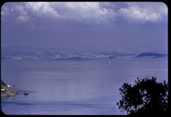
- Subject:
- East Bay Hills (Calif.), Vessels, Islands, Mountains, Angel Island (Calif.), Trees, Dwellings, Bays (Bodies of water), San Francisco Bay (Calif.), Streets, A...
- Series:
- 8-40
- Creator:
- Cushman, Charles W., 1896-1972
- Date Created:
- 1940-07-01
- Genre:
- Views
- Frame Number:
- 17
- County:
- Marin and San Francisco
- Abstract:
- Sausolito, Angel Island, and East Bay Hills.
- Call Number:
- P01900
- City:
- San Francisco and Sausalito
- Country:
- United States
- State/Province:
- California
- Physical Description:
- Image was originally mounted in a glass enclosure. Before digitization, the image was removed and placed in a Wess Plastic, Inc. brand, 2" x 2", pl...
- Alternate Identifier:
- 840.17
- Persistent URL:
- http://purl.dlib.indiana.edu/iudl/archives/cushman/P01900
- Holding Location:
- Bloomington - University Archives
Wells Library E460
1320 E 10th St.
Bloomington, IN 47405
Contact at archives@indiana.edu, 812-855-1127
-
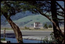
- Description:
- 100 f 11 tl
- Subject:
- Catalpas, Catalpa, Hills, Windows, Mountains, Shrubs, Electric lines, Trees, Fences, and Houses
- Series:
- 16-59
- Creator:
- Cushman, Charles W., 1896-1972
- Date Created:
- 1959-10-03
- Genre:
- Identification photographs
- Frame Number:
- 22
- County:
- Marin
- Abstract:
- Catalpa- Bolinas Bay
- Call Number:
- P10874
- City:
- Bolinas
- Country:
- United States
- State/Province:
- California
- Physical Description:
- Anscochrome film.
- Alternate Identifier:
- 1659.22
- Persistent URL:
- http://purl.dlib.indiana.edu/iudl/archives/cushman/P10874
- Holding Location:
- Bloomington - University Archives
Wells Library E460
1320 E 10th St.
Bloomington, IN 47405
Contact at archives@indiana.edu, 812-855-1127
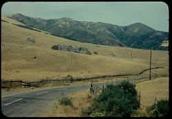
-
- Description:
- 100 f 8 tl
- Subject:
- Cows, Hills, Mountains, Rocks, Grazing, and Grasses
- Series:
- 7-56
- Creator:
- Cushman, Charles W., 1896-1972
- Date Created:
- 1956-06-09
- Genre:
- Landscape photographs
- Frame Number:
- 28
- Street Address:
- Chileno Valley Road
- County:
- Marin
- Abstract:
- Grazing cows from along Chileno Valley road - Chileno Val. Rd.
- Call Number:
- P08775
- Country:
- United States
- State/Province:
- California
- Alternate Identifier:
- 756.28
- Persistent URL:
- http://purl.dlib.indiana.edu/iudl/archives/cushman/P08775
- Holding Location:
- Bloomington - University Archives
Wells Library E460
1320 E 10th St.
Bloomington, IN 47405
Contact at archives@indiana.edu, 812-855-1127
-
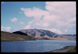
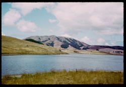
- Description:
- 100 f 11
- Subject:
- Lakes & ponds, Black Mountain (Marin County, Calif.), Hills, Mountains, Coastlines, and Clouds
- Series:
- 27-65
- Creator:
- Cushman, Charles W., 1896-1972
- Date Created:
- 1965-07-26
- Genre:
- Landscape photographs
- Frame Number:
- 5
- County:
- Marin
- Abstract:
- Black Mtn.
- Call Number:
- P14804
- Country:
- United States
- State/Province:
- California
- Alternate Identifier:
- 2765.5
- Persistent URL:
- http://purl.dlib.indiana.edu/iudl/archives/cushman/P14804
- Holding Location:
- Bloomington - University Archives
Wells Library E460
1320 E 10th St.
Bloomington, IN 47405
Contact at archives@indiana.edu, 812-855-1127
-
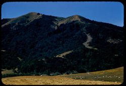
- Description:
- 100 f 6.3 tl
- Subject:
- Sheep, Meadows, Mountains, Hicks Mountain (Calif.), Hay, Trees, and Farms
- Series:
- 7-56
- Creator:
- Cushman, Charles W., 1896-1972
- Date Created:
- 1956-06-09
- Genre:
- Landscape photographs
- Frame Number:
- 20
- County:
- Marin
- Abstract:
- Hicks Mtn- Marin county
- Call Number:
- P08767
- Country:
- United States
- State/Province:
- California
- Alternate Identifier:
- 756.20
- Persistent URL:
- http://purl.dlib.indiana.edu/iudl/archives/cushman/P08767
- Holding Location:
- Bloomington - University Archives
Wells Library E460
1320 E 10th St.
Bloomington, IN 47405
Contact at archives@indiana.edu, 812-855-1127
-

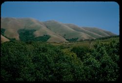
- Description:
- 100 f 8 TL
- Subject:
- Meadows, Black Mountain (Marin County, Calif.), Hills, Animals, Mountains, Trees, Grazing, and Fences
- Series:
- 1-63
- Creator:
- Cushman, Charles W., 1896-1972
- Date Created:
- 1963-04-09
- Genre:
- Landscape photographs
- Frame Number:
- 14
- County:
- Marin
- Abstract:
- Black Mtn
- Call Number:
- P12818
- Country:
- United States
- State/Province:
- California
- Alternate Identifier:
- 163.14
- Persistent URL:
- http://purl.dlib.indiana.edu/iudl/archives/cushman/P12818
- Holding Location:
- Bloomington - University Archives
Wells Library E460
1320 E 10th St.
Bloomington, IN 47405
Contact at archives@indiana.edu, 812-855-1127
-
- Description:
- 100 f 6.3 tl
- Subject:
- Cities & towns, Bodies of water, Roads, Mountains, Utility poles, Trees, Buildings, Coastlines, Clouds, East Bay (Calif.), Dwellings, Vehicles, and Light...
- Series:
- 5-55
- Creator:
- Cushman, Charles W., 1896-1972
- Date Created:
- 1955-03-10
- Genre:
- Cityscape photographs
- Frame Number:
- 10
- County:
- Marin
- Abstract:
- Toward East Bay cities from Belvedere was cut long at 9 end
- Call Number:
- P07675
- City:
- Belvedere
- Country:
- United States
- State/Province:
- California
- Alternate Identifier:
- 555.10
- Persistent URL:
- http://purl.dlib.indiana.edu/iudl/archives/cushman/P07675
- Holding Location:
- Bloomington - University Archives
Wells Library E460
1320 E 10th St.
Bloomington, IN 47405
Contact at archives@indiana.edu, 812-855-1127
-
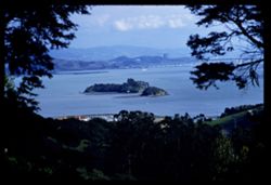
- Description:
- 100 f 6.3 TL
- Subject:
- Paradise Bay (Marin County, Calif.), Hills, Mountains, Trees, Piers & wharves, Houses, Bays (Bodies of water), and Buildings
- Series:
- 22-61
- Creator:
- Cushman, Charles W., 1896-1972
- Date Created:
- 1961-10-06
- Genre:
- Marine photographs and Cityscape photographs
- Frame Number:
- 3
- County:
- Marin
- Abstract:
- Paradise Cay
- Call Number:
- P12494
- Country:
- United States
- State/Province:
- California
- Alternate Identifier:
- 2261.3
- Persistent URL:
- http://purl.dlib.indiana.edu/iudl/archives/cushman/P12494
- Holding Location:
- Bloomington - University Archives
Wells Library E460
1320 E 10th St.
Bloomington, IN 47405
Contact at archives@indiana.edu, 812-855-1127
-
- Description:
- 100 f 6.3 tl
- Subject:
- Cities & towns, San Francisco Bay (Calif.), Mountains, Tamalpais, Mount (Calif.), and Bays (Bodies of water)
- Series:
- 15-57
- Creator:
- Cushman, Charles W., 1896-1972
- Date Created:
- 1957-10-03
- Genre:
- Landscape photographs, Cityscape photographs, and Views
- Frame Number:
- 29
- County:
- Marin
- Abstract:
- Toward San Rafael
- Call Number:
- P09559
- City:
- San Rafael
- Country:
- United States
- State/Province:
- California
- Alternate Identifier:
- 1557.29
- Persistent URL:
- http://purl.dlib.indiana.edu/iudl/archives/cushman/P09559
- Holding Location:
- Bloomington - University Archives
Wells Library E460
1320 E 10th St.
Bloomington, IN 47405
Contact at archives@indiana.edu, 812-855-1127
-
- Description:
- 50 f 8 SL
- Subject:
- Meadows, Flowers, Mountains, Point Reyes Peninsula (Calif.), Fences, Point Reyes (Calif.), and Black Mountain (Sonoma County, Calif.)
- Series:
- 7-56
- Creator:
- Cushman, Charles W., 1896-1972
- Date Created:
- 1956-05-11
- Genre:
- Landscape photographs
- Frame Number:
- 1
- Street Address:
- Point Reyes-Petaluma Road
- County:
- Sonoma and Marin
- Abstract:
- Black Mtn. & pink wild flowers seem from Pt. Reyes - Petaluma road on the east
- Call Number:
- P08748
- City:
- Petaluma
- Country:
- United States
- State/Province:
- California
- Alternate Identifier:
- 756.1
- Persistent URL:
- http://purl.dlib.indiana.edu/iudl/archives/cushman/P08748
- Holding Location:
- Bloomington - University Archives
Wells Library E460
1320 E 10th St.
Bloomington, IN 47405
Contact at archives@indiana.edu, 812-855-1127
-
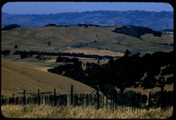
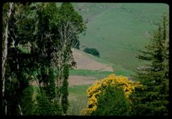
- Description:
- 100 f 8 tl
- Subject:
- Valleys, Hills, Mountains, Trees, Sonoma Mountain (Calif.), Farms, Grasses, and Fences
- Series:
- 7-56
- Creator:
- Cushman, Charles W., 1896-1972
- Date Created:
- 1956-06-09
- Genre:
- Landscape photographs
- Frame Number:
- 25
- Street Address:
- Marshall Petaluma Road
- County:
- Sonoma and Marin
- Abstract:
- Eastward from lower
- Call Number:
- P08772
- Country:
- United States
- State/Province:
- California
- Alternate Identifier:
- 756.25
- Persistent URL:
- http://purl.dlib.indiana.edu/iudl/archives/cushman/P08772
- Holding Location:
- Bloomington - University Archives
Wells Library E460
1320 E 10th St.
Bloomington, IN 47405
Contact at archives@indiana.edu, 812-855-1127
-
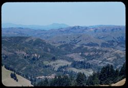
- Description:
- 100 f 6.3 tl
- Subject:
- Diablo, Mount (Calif.), San Francisco Bay (Calif.), Bays (Bodies of water), Tamalpais, Mount (Calif.), Rocks, Coastlines, Clouds, Mists, and Mountains
- Series:
- 14-56
- Creator:
- Cushman, Charles W., 1896-1972
- Date Created:
- 1956-11-07
- Genre:
- Landscape photographs
- Frame Number:
- 25
- County:
- Marin and Contra Costa
- Abstract:
- Mt. Diablo from Tamalpais
- Call Number:
- P09022
- Country:
- United States
- State/Province:
- California
- Alternate Identifier:
- 1456.25
- Persistent URL:
- http://purl.dlib.indiana.edu/iudl/archives/cushman/P09022
- Holding Location:
- Bloomington - University Archives
Wells Library E460
1320 E 10th St.
Bloomington, IN 47405
Contact at archives@indiana.edu, 812-855-1127
-
- Description:
- 100 f 6.3 tl
- Subject:
- Cities & towns, Hills, Roads, Mountains, Tamalpais, Mount (Calif.), Shadows, San Bruno Mountain (Calif.), and Bays (Bodies of water)
- Series:
- 29-55
- Creator:
- Cushman, Charles W., 1896-1972
- Date Created:
- 1955-10-31
- Genre:
- Landscape photographs and Cityscape photographs
- Frame Number:
- 10
- County:
- Marin and San Francisco
- Abstract:
- Toward SE - to San Bruno Mtn
- Call Number:
- P08501
- City:
- San Francisco
- Country:
- United States
- State/Province:
- California
- Alternate Identifier:
- 2955.10
- Persistent URL:
- http://purl.dlib.indiana.edu/iudl/archives/cushman/P08501
- Holding Location:
- Bloomington - University Archives
Wells Library E460
1320 E 10th St.
Bloomington, IN 47405
Contact at archives@indiana.edu, 812-855-1127
-
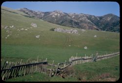
- Description:
- 50 f 9 haze filter
- Subject:
- Croplands, Meadows, Hills, Roads, Mountains, Shrubs, Trees, Rocks, Grasses, Fences, and Salmon Creek (Marin County, Calif.)
- Series:
- 4-54
- Creator:
- Cushman, Charles W., 1896-1972
- Date Created:
- 1954-07-29
- Genre:
- Landscape photographs
- Frame Number:
- 12
- County:
- Marin
- Abstract:
- Dry pasture land - outcrop in center, dark green mtn in background along Salmon creek [ad in Main]
- Call Number:
- P07186
- Country:
- United States
- State/Province:
- California
- Physical Description:
- Anscochrome film.
- Alternate Identifier:
- 454.12
- Persistent URL:
- http://purl.dlib.indiana.edu/iudl/archives/cushman/P07186
- Holding Location:
- Bloomington - University Archives
Wells Library E460
1320 E 10th St.
Bloomington, IN 47405
Contact at archives@indiana.edu, 812-855-1127
-
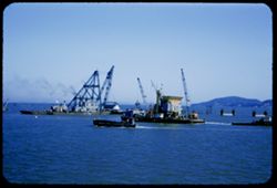
- Description:
- 50 f 9
- Subject:
- Richmond-San Rafael Bridge, Construction equipment, Bridge construction, Vessels, Bodies of water, Mountains, Boats, Hoisting machinery, Piers & wharves,...
- Series:
- 2-54
- Creator:
- Cushman, Charles W., 1896-1972
- Date Created:
- 1954-05-21
- Genre:
- Marine photographs
- Frame Number:
- 7
- County:
- Marin
- Abstract:
- Aboard Ferry Boat Russian River from San Rafael to Richmond Piers of new bridge
- Call Number:
- P07280
- Country:
- United States
- State/Province:
- California
- Alternate Identifier:
- 254.7
- Persistent URL:
- http://purl.dlib.indiana.edu/iudl/archives/cushman/P07280
- Holding Location:
- Bloomington - University Archives
Wells Library E460
1320 E 10th St.
Bloomington, IN 47405
Contact at archives@indiana.edu, 812-855-1127
-
- Description:
- 50 f 5.6 Pola
- Subject:
- Black Mountain (Marin County, Calif.), Tomales Bay (Calif.), Mountains, Women, Trees, Grasses, and Wildflowers
- Series:
- 7-53
- Creator:
- Cushman, Charles W., 1896-1972
- Date Created:
- 1953-06-17
- Genre:
- Landscape photographs
- Frame Number:
- 9
- County:
- Marin
- Abstract:
- Black Mtn. - Marin county near Point Reyes Station.
- Call Number:
- P06734
- City:
- Point Reyes Station
- Country:
- United States
- State/Province:
- California
- Physical Description:
- Image was originally mounted in a glass enclosure. Before digitization, the image was removed and placed in a Wess Plastic, Inc. brand, 2" x 2", pl...
- Alternate Identifier:
- 753.9
- Persistent URL:
- http://purl.dlib.indiana.edu/iudl/archives/cushman/P06734
- Holding Location:
- Bloomington - University Archives
Wells Library E460
1320 E 10th St.
Bloomington, IN 47405
Contact at archives@indiana.edu, 812-855-1127
-
- Description:
- 100 f 8 tl
- Subject:
- Cities & towns, Mountains, Tamalpais, Mount (Calif.), and Buildings
- Series:
- 1-57
- Creator:
- Cushman, Charles W., 1896-1972
- Date Created:
- 1957-03-22
- Genre:
- Landscape photographs and Cityscape photographs
- Frame Number:
- 20
- County:
- Marin
- Abstract:
- Mt. Tamalpais from top of Waldo grade
- Call Number:
- P09126
- City:
- Waldo
- Country:
- United States
- State/Province:
- California
- Alternate Identifier:
- 157.20
- Persistent URL:
- http://purl.dlib.indiana.edu/iudl/archives/cushman/P09126
- Holding Location:
- Bloomington - University Archives
Wells Library E460
1320 E 10th St.
Bloomington, IN 47405
Contact at archives@indiana.edu, 812-855-1127
-
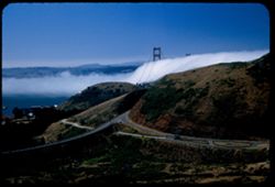
- Description:
- 25 f 8 Pola
- Subject:
- Bays (Bodies of water), Grasses, Roads, Golden Gate Bridge (San Francisco, Calif.), Fog, Trees, Mountains, Buildings, Tunnels, Hills, Waldo Tunnel (Calif.), ...
- Series:
- 7-53
- Creator:
- Cushman, Charles W., 1896-1972
- Date Created:
- 1953-07-08
- Genre:
- Views
- Frame Number:
- 25
- County:
- Marin and San Francisco
- Abstract:
- Fog through the Golden Gate from Waldo Tunnel entrance.
- Call Number:
- P06750
- City:
- San Francisco
- Country:
- United States
- State/Province:
- California
- Alternate Identifier:
- 753.25
- Persistent URL:
- http://purl.dlib.indiana.edu/iudl/archives/cushman/P06750
- Holding Location:
- Bloomington - University Archives
Wells Library E460
1320 E 10th St.
Bloomington, IN 47405
Contact at archives@indiana.edu, 812-855-1127
-
- Description:
- 100 f 8 tl
- Subject:
- Trees, Saint Helena, Mount (Calif.), Mountains, Tamalpais, Mount (Calif.), and Hills
- Series:
- 2-56
- Creator:
- Cushman, Charles W., 1896-1972
- Date Created:
- 1956-03-14
- Genre:
- Landscape photographs
- Frame Number:
- 4
- County:
- Marin
- Abstract:
- Distant view north - toward Mt. St. Helena noon
- Call Number:
- P08570
- Country:
- United States
- State/Province:
- California
- Alternate Identifier:
- 256.4
- Persistent URL:
- http://purl.dlib.indiana.edu/iudl/archives/cushman/P08570
- Holding Location:
- Bloomington - University Archives
Wells Library E460
1320 E 10th St.
Bloomington, IN 47405
Contact at archives@indiana.edu, 812-855-1127
-
- Description:
- 25 f 11
- Subject:
- Rocky Point (Marin County, Calif.), Oceans, Grasses, Ocean waves, Trees, Pacific Ocean, Mountains, Pacific Coast (Calif.), and Rocks
- Series:
- 7-53
- Creator:
- Cushman, Charles W., 1896-1972
- Date Created:
- 1953-07-08
- Genre:
- Seascapes
- Frame Number:
- 32
- Street Address:
- California State Highway 1
- County:
- Marin
- Abstract:
- Pacific shore.
- Call Number:
- P06756
- Country:
- United States
- State/Province:
- California
- Alternate Identifier:
- 753.32
- Persistent URL:
- http://purl.dlib.indiana.edu/iudl/archives/cushman/P06756
- Holding Location:
- Bloomington - University Archives
Wells Library E460
1320 E 10th St.
Bloomington, IN 47405
Contact at archives@indiana.edu, 812-855-1127
-
- Description:
- 100 f 8
- Subject:
- Houses, Bolinas Lagoon (Calif.), Trees, Coastlines, Mountains, Beaches, Lakes & ponds, Forests, and Hills
- Series:
- 1-68
- Creator:
- Cushman, Charles W., 1896-1972
- Date Created:
- 1968-03-20
- Genre:
- Landscape photographs
- Frame Number:
- 32
- County:
- Marin
- Abstract:
- Across Bolinas lagoon (east) from Bolinas beach
- Call Number:
- P15626
- City:
- Bolinas
- Country:
- United States
- State/Province:
- California
- Alternate Identifier:
- 168.32
- Persistent URL:
- http://purl.dlib.indiana.edu/iudl/archives/cushman/P15626
- Holding Location:
- Bloomington - University Archives
Wells Library E460
1320 E 10th St.
Bloomington, IN 47405
Contact at archives@indiana.edu, 812-855-1127
-
- Description:
- 100 f 8
- Subject:
- Roads, Stilt houses, Trees, Tree limbs, Mountains, Fences, Lakes & ponds, and Hills
- Series:
- 1-68
- Creator:
- Cushman, Charles W., 1896-1972
- Date Created:
- 1968-03-20
- Genre:
- Views
- Frame Number:
- 34
- County:
- Marin
- Abstract:
- Across Bolinas lagoon
- Call Number:
- P15628
- City:
- Bolinas
- Country:
- United States
- State/Province:
- California
- Alternate Identifier:
- 168.34
- Persistent URL:
- http://purl.dlib.indiana.edu/iudl/archives/cushman/P15628
- Holding Location:
- Bloomington - University Archives
Wells Library E460
1320 E 10th St.
Bloomington, IN 47405
Contact at archives@indiana.edu, 812-855-1127
-
- Subject:
- Trees, Mountains, Tamalpais, Mount (Calif.), and Hills
- Series:
- 1-68
- Creator:
- Cushman, Charles W., 1896-1972
- Date Created:
- 1968-03-20
- Genre:
- Landscape photographs
- Frame Number:
- 31
- County:
- Marin
- Abstract:
- Toward Tamalpais from Bolinas
- Call Number:
- P15625
- City:
- Bolinas
- Country:
- United States
- State/Province:
- California
- Alternate Identifier:
- 168.31
- Persistent URL:
- http://purl.dlib.indiana.edu/iudl/archives/cushman/P15625
- Holding Location:
- Bloomington - University Archives
Wells Library E460
1320 E 10th St.
Bloomington, IN 47405
Contact at archives@indiana.edu, 812-855-1127
-
- Description:
- 100 f 11 tl
- Subject:
- Bays (Bodies of water), Oceans, Seas, Bolinas Lagoon (Calif.), Trees, Coastlines, Bolinas Bay (Calif.), Mountains, Beaches, Forests, Hills, and Sandbars
- Series:
- 26-65
- Creator:
- Cushman, Charles W., 1896-1972
- Date Created:
- 1965-07-09
- Genre:
- Landscape photographs and Seascapes
- Frame Number:
- 36
- County:
- Marin
- Call Number:
- P14797
- Country:
- United States
- State/Province:
- California
- Alternate Identifier:
- 2665.36
- Persistent URL:
- http://purl.dlib.indiana.edu/iudl/archives/cushman/P14797
- Holding Location:
- Bloomington - University Archives
Wells Library E460
1320 E 10th St.
Bloomington, IN 47405
Contact at archives@indiana.edu, 812-855-1127
-
- Description:
- 100 f 6.3 tl
- Subject:
- Wildflowers, Valleys, Meadows, Mountains, Forests, and Black Mountain (Marin County, Calif.)
- Series:
- 4-57
- Creator:
- Cushman, Charles W., 1896-1972
- Date Created:
- 1957-04-25
- Genre:
- Landscape photographs
- Frame Number:
- 11
- County:
- Marin
- Abstract:
- Black Mtn is all green
- Call Number:
- P09195
- Country:
- United States
- State/Province:
- California
- Alternate Identifier:
- 457.11
- Persistent URL:
- http://purl.dlib.indiana.edu/iudl/archives/cushman/P09195
- Holding Location:
- Bloomington - University Archives
Wells Library E460
1320 E 10th St.
Bloomington, IN 47405
Contact at archives@indiana.edu, 812-855-1127
-
- Description:
- 50 f 9
- Subject:
- Grasses, Grazing, Farms, Trees, Cattle, Mountains, Shrubs, Cows, Black Mountain (Marin County, Calif.), and Hills
- Series:
- 2-54
- Creator:
- Cushman, Charles W., 1896-1972
- Date Created:
- 1954-05-21
- Genre:
- Landscape photographs
- Frame Number:
- 5
- County:
- Marin
- Abstract:
- Cows graze below Black Mtn. - Marin county
- Call Number:
- P07136
- Country:
- United States
- State/Province:
- California
- Alternate Identifier:
- 254.5
- Persistent URL:
- http://purl.dlib.indiana.edu/iudl/archives/cushman/P07136
- Holding Location:
- Bloomington - University Archives
Wells Library E460
1320 E 10th St.
Bloomington, IN 47405
Contact at archives@indiana.edu, 812-855-1127
-

- Description:
- 100 f 5.6 tl
- Subject:
- Bodies of water, Angel Island (Calif.), Trees, Coastlines, Streets, Mountains, Buildings, Shrubs, Clouds, Islands, Tamalpais, Mount (Calif.), Hills, and Dwel...
- Series:
- 5-55
- Creator:
- Cushman, Charles W., 1896-1972
- Date Created:
- 1955-03-10
- Genre:
- Landscape photographs
- Frame Number:
- 19
- Street Address:
- Tamalpais Road
- County:
- Marin
- Abstract:
- View ESE east from Tamalpais road toward Angel Island were out too far to left and had to be remounted
- Call Number:
- P07684
- City:
- Belvedere
- Country:
- United States
- State/Province:
- California
- Alternate Identifier:
- 555.19
- Persistent URL:
- http://purl.dlib.indiana.edu/iudl/archives/cushman/P07684
- Holding Location:
- Bloomington - University Archives
Wells Library E460
1320 E 10th St.
Bloomington, IN 47405
Contact at archives@indiana.edu, 812-855-1127
-
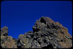
- Description:
- 100 f 6.3 tl
- Subject:
- Mountains, Rock formations, and Tamalpais, Mount (Calif.)
- Series:
- 28-55
- Creator:
- Cushman, Charles W., 1896-1972
- Date Created:
- 1955-10-12
- Genre:
- Landscape photographs
- Frame Number:
- 20
- County:
- Marin
- Abstract:
- Craggy rock near top of Mt. Tamalpais
- Call Number:
- P08475
- Country:
- United States
- State/Province:
- California
- Alternate Identifier:
- 2855.20
- Persistent URL:
- http://purl.dlib.indiana.edu/iudl/archives/cushman/P08475
- Holding Location:
- Bloomington - University Archives
Wells Library E460
1320 E 10th St.
Bloomington, IN 47405
Contact at archives@indiana.edu, 812-855-1127
-
- Description:
- 50 f 9
- Subject:
- San Quentin Bridge (Calif.), Bodies of water, Trees, Cities & towns, Buildings, Shrubs, Tamalpais, Mount (Calif.), Hills, and Mountains
- Series:
- 16-54
- Creator:
- Cushman, Charles W., 1896-1972
- Date Created:
- 1954-10-23
- Genre:
- Landscape photographs
- Frame Number:
- 3
- County:
- Marin
- Abstract:
- View east from Tamalpais down toward San Quentin + [?] bridge.
- Call Number:
- P07502
- Country:
- United States
- State/Province:
- California
- Physical Description:
- Anscochrome film.
- Alternate Identifier:
- 1654.3
- Persistent URL:
- http://purl.dlib.indiana.edu/iudl/archives/cushman/P07502
- Holding Location:
- Bloomington - University Archives
Wells Library E460
1320 E 10th St.
Bloomington, IN 47405
Contact at archives@indiana.edu, 812-855-1127
-
- Description:
- 25 f 6.3 pola
- Subject:
- Bays (Bodies of water), Apartment houses, Golden Gate Bridge (San Francisco, Calif.), Suspension bridges, Roofs, Mountains, Buildings, Clouds, Coit Memorial ...
- Series:
- 10-52
- Creator:
- Cushman, Charles W., 1896-1972
- Date Created:
- 1952-03-12
- Genre:
- Cityscape photographs
- Frame Number:
- 17
- County:
- Marin and San Francisco
- Abstract:
- Golden Gate Bridge from Coit Tower [bse]
- Call Number:
- P05849
- City:
- San Francisco
- Country:
- United States
- State/Province:
- California
- Alternate Identifier:
- 1052.17
- Persistent URL:
- http://purl.dlib.indiana.edu/iudl/archives/cushman/P05849
- Holding Location:
- Bloomington - University Archives
Wells Library E460
1320 E 10th St.
Bloomington, IN 47405
Contact at archives@indiana.edu, 812-855-1127
-
- Description:
- 100 f 8 tl
- Subject:
- Bays (Bodies of water), Richmond-San Rafael Bridge, Mountains, Bridges, Tamalpais, Mount (Calif.), Hills, Canals, and Cities & towns
- Series:
- 2-56
- Creator:
- Cushman, Charles W., 1896-1972
- Date Created:
- 1956-03-14
- Genre:
- Cityscape photographs
- Frame Number:
- 14
- County:
- Marin and Contra Costa
- Abstract:
- New San Rafael - Richmond Bridge from east point
- Call Number:
- P08580
- City:
- Richmond and San Rafael
- Country:
- United States
- State/Province:
- California
- Alternate Identifier:
- 256.14
- Persistent URL:
- http://purl.dlib.indiana.edu/iudl/archives/cushman/P08580
- Holding Location:
- Bloomington - University Archives
Wells Library E460
1320 E 10th St.
Bloomington, IN 47405
Contact at archives@indiana.edu, 812-855-1127
-
- Description:
- 100 f 8 tl
- Subject:
- Roads, Farms, Trees, Mountains, Sonoma Mountain (Calif.), Hills, and Houses
- Series:
- 7-56
- Creator:
- Cushman, Charles W., 1896-1972
- Date Created:
- 1956-06-09
- Genre:
- Landscape photographs
- Frame Number:
- 24
- Street Address:
- Marshall Petaluma Road
- County:
- Marin and Sonoma
- Abstract:
- Eastward from Marshall Petaluma road high point toward Sonoma Mtns
- Call Number:
- P08771
- Country:
- United States
- State/Province:
- California
- Alternate Identifier:
- 756.24
- Persistent URL:
- http://purl.dlib.indiana.edu/iudl/archives/cushman/P08771
- Holding Location:
- Bloomington - University Archives
Wells Library E460
1320 E 10th St.
Bloomington, IN 47405
Contact at archives@indiana.edu, 812-855-1127
-
- Description:
- 100 f 5.6 TL
- Subject:
- Piers & wharves, Channels, Trees, San Pablo Strait (Calif.), Tree limbs, Mountains, Buildings, Bridges, Islands, and Hills
- Series:
- 2-60
- Creator:
- Cushman, Charles W., 1896-1972
- Date Created:
- 1960-03-08
- Genre:
- Landscape photographs
- Frame Number:
- 8
- County:
- Marin
- Abstract:
- From ht. East of S. Rafael - Marin Islands in San Pablo str.
- Call Number:
- P10939
- City:
- San Rafael
- Country:
- United States
- State/Province:
- California
- Alternate Identifier:
- 260.8
- Persistent URL:
- http://purl.dlib.indiana.edu/iudl/archives/cushman/P10939
- Holding Location:
- Bloomington - University Archives
Wells Library E460
1320 E 10th St.
Bloomington, IN 47405
Contact at archives@indiana.edu, 812-855-1127
-
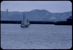
- Description:
- 100 f 5.6 tl
- Subject:
- Bays (Bodies of water), Piers & wharves, Sailboats, Golden Gate Bridge (San Francisco, Calif.), Suspension bridges, Mountains, and San Francisco Bay (Cal...
- Series:
- 2-57
- Creator:
- Cushman, Charles W., 1896-1972
- Date Created:
- 1957-03-30
- Genre:
- Marine photographs
- Frame Number:
- 8
- Street Address:
- North Beach
- County:
- Marin and San Francisco
- Abstract:
- View from former Sausalito ferry slip San Francisco
- Call Number:
- P09134
- City:
- San Francisco
- Country:
- United States
- State/Province:
- California
- Alternate Identifier:
- 257.8
- Persistent URL:
- http://purl.dlib.indiana.edu/iudl/archives/cushman/P09134
- Holding Location:
- Bloomington - University Archives
Wells Library E460
1320 E 10th St.
Bloomington, IN 47405
Contact at archives@indiana.edu, 812-855-1127
-
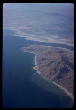
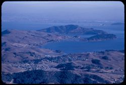
- Subject:
- Bays (Bodies of water), Oceans, Tomales Bay (Calif.), Pacific Ocean, Mountains, Land, Coastlines, and Pacific Coast (Calif.)
- Series:
- 22-60
- Creator:
- Cushman, Charles W., 1896-1972
- Date Created:
- 1960-07-11
- Genre:
- Aerial photographs
- Frame Number:
- 37
- County:
- Marin
- Call Number:
- P11624
- Country:
- United States
- State/Province:
- California
- Alternate Identifier:
- 2260.37
- Persistent URL:
- http://purl.dlib.indiana.edu/iudl/archives/cushman/P11624
- Holding Location:
- Bloomington - University Archives
Wells Library E460
1320 E 10th St.
Bloomington, IN 47405
Contact at archives@indiana.edu, 812-855-1127