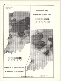
2 maps on 1 sheet, Cropland, 1964, as a percent of total land and Harvested cropland, 1964, as a percent of total land. Computer generated isopleth maps obta...
Call Number:
G4091.J1 1964 .K56
Caption:
Imprint: Bloomington, Indiana : Department of Geography, Indiana University, [1970]
Physical Description:
Dimensions: each 26 x 10 cm, on sheet 28 x 21 cm and Scale: Approximately 1:3,000,000
Alternate Identifier:
Alternate ID: 317383IP and Title Control Number: a15995410
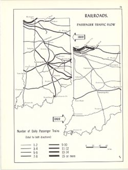
2 maps on 1 sheet. Shows number of daily passenger trains on Indiana railways in 1869 and 1969. Detached from: An atlas of Indiana / by Robert C. Kingsbur...
Call Number:
G4091.P3 1969 .K57
Caption:
Imprint: Bloomington, Indiana : Department of Geography, Indiana University, [1970]
Physical Description:
Scale: Approximately 1:2,880,000 and Dimensions: on sheet 28 x 21 cm
Alternate Identifier:
Alternate ID: 317383IP and Title Control Number: a15934583
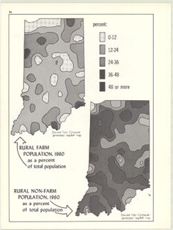
2 maps on 1 sheet, Rural farm population, 1960, as a percent of total population and Rural non-farm population, 1960, as a percent of total population. Compu...
Call Number:
G4091.E2 1960 .K59
Caption:
Imprint: Bloomington, Indiana : Department of Geography, Indiana University, [1970]
Physical Description:
Dimensions: on sheet 28 x 21 cm and Scale: Approximately 1:3,000,000
Alternate Identifier:
Title Control Number: a15948031 and Alternate ID: 317383IP
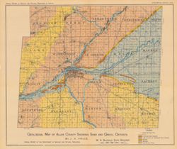
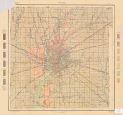
Shows roads, gravel and sand deposits, lake bottoms and abandoned river channels, beaches, moraines, and inter-moranic plains. Also shows cemeteries and chur...
Call Number:
G4093.A4H5 1905 .P7
Caption:
Imprint: [Indianapolis] : [Indiana Department of Geology and Natural Resources], [1906]
Physical Description:
Dimensions: 38 x 45 cm and Scale: Approximately 1:126,720. 2 miles = 1 inch
Alternate Identifier:
Alternate ID: 390726IP and Title Control Number: a18298916
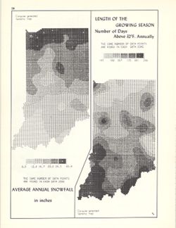
2 maps on 1 sheet, Average annual snowfall in inches and Length of the growing season: number of days above 32°F. annually. Computer generated isometric ...
Call Number:
G4091.C884 1970 .K56
Caption:
Imprint: Bloomington, Indiana : Department of Geography, Indiana University, [1970]
Physical Description:
Scale: Approximately 1:3,000,000 and Dimensions: each 26 x 10 cm, on sheet 28 x 21 cm
Alternate Identifier:
Alternate ID: 317383IP and Title Control Number: a15998435

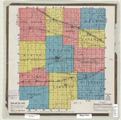
![Spencer County [Indiana] land use map : preliminary](https://iiif.uits.iu.edu/iiif/2/1c18fj180%2Ffiles%2F9c0b4a8c-6bc8-420c-af21-908a4b5f3ba4/full/250,/0/default.jpg)
