
Search Constraints
You searched for:
Type
Image
Remove constraint Type: Image
Publisher
Indiana. Geological Survey
Remove constraint Publisher: Indiana. Geological Survey
Search Results
-
- Subject:
- Topical Subject: IGS Annual Reports, Topical Subject: Coal, Geographic Subject: Indiana, and Topical Subject: Geology, Stratigraphic
- Creator:
- Levette, G. M. (Gilbert M.)
- Publisher:
- Indiana. Geological Survey
- Date Created:
- 1869
- Identifier:
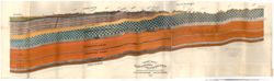
- VAC3073-M-01169
- Genre:
- Geological cross-sections
- Geographic Location:
- Coordinates: W0873150 W0864800 N0393954 N0392456
- Related URL:
- Catalog URL: https://iucat.iu.edu/catalog/18225036
- Abstract:
- Geological cross section. Relief shown by profile. Detached from: First annual report of the Geological Survey of Indiana ... 1869. Indianapolis : Alexand...
- Call Number:
- G4091.C57 1869 .L4
- Caption:
- Imprint: [Indianapolis] : [Alexander M. Conner], [1869] and Imprint: [Indianapolis] : [Geological Survey of Indiana], 1869
- Physical Description:
- Dimensions: 34 x 117 cm and Scale: Approximately 1:95,040. 1 1/2 miles to 1 in. Vertical scale approximately 1:2,400. 200 ft. to 1 in.
- Alternate Identifier:
- Title Control Number: a18225036
- Persistent URL:
- https://purl.dlib.indiana.edu/iudl/images/VAC3073/VAC3073-M-01169
- Provenance:
- 1st Annual Report (1869) / Indiana. Geological Survey
-
- Subject:
- Topical Subject: IGS Annual Reports, Topical Subject: Coal mines and mining, Topical Subject: Lumber trade, Geographic Subject: Vigo County (Ind.), Topical S...
- Creator:
- Collett, John, 1828-1899
- Publisher:
- Indiana. Geological Survey
- Date Created:
- 1869
- Identifier:
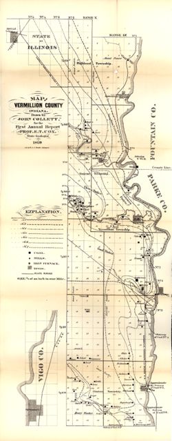
- VAC3073-M-01158
- Genre:
- Geological maps
- Geographic Location:
- Coordinates: W0873159 W0872113 N0400854 N0393626
- Related URL:
- Catalog URL: https://iucat.iu.edu/catalog/16799192
- Abstract:
- Drawn by John Collett for the 1st annual report of Prof. E.T. Cox, State Geologist, 1869 , lith. by W & J. Braden. Shows towns, railroads, coal, mills...
- Call Number:
- G4093.V4 1869 .C6
- Caption:
- Imprint: [Indianapolis] : [Alexander H. Conner, State Printer], [1869] and Imprint: [Indianapolis] : [Geological Survey of Indiana], [1869]
- Physical Description:
- Dimensions: on sheet 77 x 32 cm and Scale: Approximately 1:85,000. 3/4 of an inch to one mile
- Alternate Identifier:
- Title Control Number: a16799192 and Alternate ID: 390720IP
- Persistent URL:
- https://purl.dlib.indiana.edu/iudl/images/VAC3073/VAC3073-M-01158
- Provenance:
- 1st Annual Report (1869) / Indiana. Geological Survey
-
- Subject:
- Topical Subject: Geology, Geographic Subject: Clark County (Ind.), Topical Subject: Mines and mineral resources, Geographic Subject: Floyd County (Ind.), and...
- Creator:
- Cox, E. T. (Edward Travers), 1821-1907 and Borden, W. W. (William Wesley), 1823-1906
- Publisher:
- Indiana. Geological Survey
- Date Created:
- 1874
- Identifier:
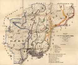
- VAC3073-M-01155
- Genre:
- Geological maps
- Geographic Location:
- Coordinates: W0860258 W0852426 N0383636 N0380900
- Related URL:
- Catalog URL: https://iucat.iu.edu/catalog/18318611
- Abstract:
- Prepared for the 5th annual report of Prof. E.T. Cox, State Geologist, 1873 , geology by W.W. Borden. Relief shown by hachures. Shows cities and towns, railr...
- Call Number:
- G4093.C4C5 1873 .B6
- Caption:
- Imprint: [Indianapolis] : [Geological Survey of Indiana], [1874] and Imprint: [Indianapolis] : [Sentinel Co., printers], [1874]
- Physical Description:
- Dimensions: on sheet 41 x 49 cm and Scale: Approximately 1:130,000
- Alternate Identifier:
- Alternate ID: 390723IP and Title Control Number: a18318611
- Persistent URL:
- https://purl.dlib.indiana.edu/iudl/images/VAC3073/VAC3073-M-01155
- Provenance:
- 5th Annual Report (1873) / Indiana. Geological Survey.
-
- Subject:
- Topical Subject: Geology, Stratigraphic, Topical Subject: IGS Annual Reports, Topical Subject: Coal mines and mining, and Geographic Subject: Daviess County ...
- Creator:
- Wright, S. D. (Of Daviess County, Ind.), Levette, G. M. (Gilbert M.), and Cox, E. T. (Edward Travers), 1821-1907
- Publisher:
- Indiana. Geological Survey
- Date Created:
- 1871
- Identifier:
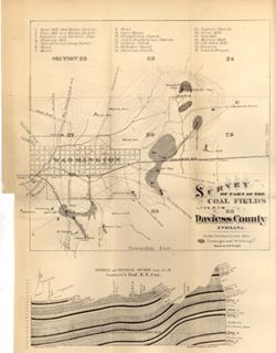
- VAC3073-M-01150
- Genre:
- Geological maps and Geological cross-sections
- Geographic Location:
- Coordinates: W0871105 W0870830 N0384031 N0383833
- Related URL:
- Catalog URL: https://iucat.iu.edu/catalog/18298907
- Abstract:
- Relief shown by contours and profile. Includes index and geological profile. Shows mills, factories, hotels, churches, halls, a brewery, and school houses. P...
- Call Number:
- G4093.D2H9 1871 .W7
- Caption:
- Imprint: [Indianapolis] : [Geological Survey of Indiana], [1871]
- Physical Description:
- Scale: Scale approximately 1:21,000. 3 in. equals 1 mile. Vertical scale approximately 1:925 and Dimensions: 36 x 28 cm
- Alternate Identifier:
- Alternate ID: 390721IP and Title Control Number: a18298907
- Persistent URL:
- https://purl.dlib.indiana.edu/iudl/images/VAC3073/VAC3073-M-01150
- Provenance:
- 2nd Annual Report (1870) / Indiana. Geological Survey.
-
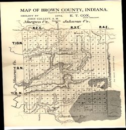
- Subject:
- Topical Subject: IGS Annual Reports, Geographic Subject: Brown County (Ind.), Topical Subject: Geology, and Topical Subject: Mines and mineral resources
- Creator:
- Collett, John, 1828-1899
- Publisher:
- Indiana. Geological Survey
- Date Created:
- 1875
- Identifier:
- VAC3073-M-01148
- Genre:
- Geological maps
- Geographic Location:
- Coordinates: W0862253 W0860449 N0392042 N0390248
- Related URL:
- Catalog URL: https://iucat.iu.edu/catalog/18318678
- Abstract:
- Prepared for the sixth annual report of E.T. Cox, State Geologist , geology by John Collett, 1874. Relief shown by hachures. Shows cities and towns, railroad...
- Call Number:
- G4093.B7C5 1874 .C6
- Caption:
- Imprint: [Indianapolis] : [Sentinel Company, printers], [1875] and Imprint: [Indianapolis] : [Geological Survey of Indiana], [1875]
- Physical Description:
- Scale: Approximately 1:120,000 and Dimensions: on sheet 39 x 35 cm
- Alternate Identifier:
- Alternate ID: 390723IP and Title Control Number: a18318678
- Persistent URL:
- https://purl.dlib.indiana.edu/iudl/images/VAC3073/VAC3073-M-01148
- Provenance:
- 6th Annual Report (1874) / Indiana. Geological Survey.
-
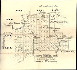
- Subject:
- Topical Subject: Landowners, Geographic Subject: Scott County (Ind.), Topical Subject: IGS Annual Reports, and Topical Subject: Real property
- Creator:
- Borden, W. W. (William Wesley), 1823-1906
- Publisher:
- Indiana. Geological Survey
- Date Created:
- 1875
- Identifier:
- VAC3073-M-01147
- Genre:
- Cadastral maps
- Geographic Location:
- Coordinates: W0855524 W0853733 N0385016 N0383454
- Related URL:
- Catalog URL: https://iucat.iu.edu/catalog/18318693
- Abstract:
- Prepared for the sixth annual report of E.T. Cox, State Geologist / geology by W.W. Borden, 1874. Relief shown by hachures. Shows cities and towns, railroads...
- Call Number:
- G4093.S3G46 1874 .B6
- Caption:
- Imprint: [Indianapolis] : [Geological Survey of Indiana], [1875] and Imprint: [Indianapolis, Indiana] : [Sentinel Co., printers], [1875]
- Physical Description:
- Scale: Approximately 1:130,000 and Dimensions: 31 x 30 cm, on sheet 38 x 35 cm
- Alternate Identifier:
- Alternate ID: 390723IP and Title Control Number: a18318693
- Persistent URL:
- https://purl.dlib.indiana.edu/iudl/images/VAC3073/VAC3073-M-01147
- Provenance:
- 6th Annual Report (1874) / Indiana. Geological Survey.
-
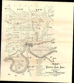
- Subject:
- Geographic Subject: Vanderburgh County (Ind.), Topical Subject: Coal mines and mining, Topical Subject: Mines and mineral resources, Topical Subject: Geology...
- Creator:
- Collett, John, 1828-1899
- Publisher:
- Indiana. Geological Survey
- Date Created:
- 1876
- Identifier:
- VAC3073-M-01146
- Genre:
- Geological maps
- Geographic Location:
- Coordinates: W0874203 W0872658 N0381006 N0374933
- Related URL:
- Catalog URL: https://iucat.iu.edu/catalog/18349316
- Abstract:
- Compiled for the 7th annual report of E.T. Cox, State Geologist , geology by Prof. John Collett, 1875. Relief shown by hachures. Shows cities and towns, rail...
- Call Number:
- G4093.V3C5 1875 .C6
- Caption:
- Imprint: [Indianapolis] : [Geological Survey of Indiana], [1876] and Imprint: [Indianapolis] : [Sentinel Company, printers], [1876]
- Physical Description:
- Scale: Approximately 1:130,000 and Dimensions: on sheet 41 x 31 cm
- Alternate Identifier:
- Alternate ID: 390723IP and Title Control Number: a18349316
- Persistent URL:
- https://purl.dlib.indiana.edu/iudl/images/VAC3073/VAC3073-M-01146
- Provenance:
- 7th Annual Report (1875) / Indiana. Geological Survey.
-
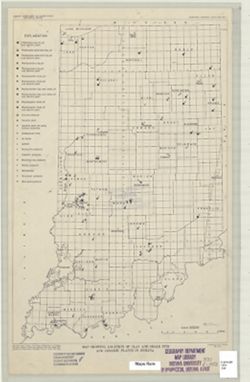
- Subject:
- Topical Subject: Shale gas industry, Topical Subject: Shale, Topical Subject: Ceramic industries, Topical Subject: Clay, Topical Subject: Clay industries, an...
- Creator:
- Murray, Haydn H. (Haydn Herbert), 1924-
- Publisher:
- Indiana. Geological Survey
- Date Created:
- 1952
- Identifier:
- VAC3073-M-00981
- Genre:
- Thematic maps
- Geographic Location:
- Coordinates: W0880000 W0844500 N0414500 N0375200
- Related URL:
- Catalog URL: https://iucat.iu.edu/catalog/8739534
- Abstract:
- "Base from Map of Indiana, 1950 edition, published by U.S. Geological Survey. Minor revisions and additions made from Indiana Department of Conservation...
- Call Number:
- G4091.H5 1952 .M8
- Caption:
- Imprint: [Bloomington, Ind.?] : Indiana Department of Conservation, Geological Survey, 1952.
- Physical Description:
- Dimensions: 45 x 31 cm and Scale: 1:1,000,000
- Alternate Identifier:
- Title Control Number: a8739534
- Persistent URL:
- https://purl.dlib.indiana.edu/iudl/images/VAC3073/VAC3073-M-00981
-
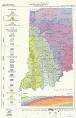
- Subject:
- Geographic Subject: Indiana and Topical Subject: Geology
- Creator:
- Purcell, Roger L.
- Publisher:
- Indiana. Geological Survey
- Date Created:
- 1970
- Identifier:
- VAC3073-M-00975
- Genre:
- Geological maps
- Geographic Location:
- Coordinates: W0880500 W0844700 N0414500 N0374600
- Related URL:
- Catalog URL: https://iucat.iu.edu/catalog/5363412
- Abstract:
- Includes geological cross-section.
- Call Number:
- G4091 .C5 1970 .P87
- Caption:
- Imprint: Indianapolis, Ind. : Indiana Geological Survey, 1970.
- Physical Description:
- Scale: 1:1,800,000 and Dimensions: 31 x 22 cm
- Alternate Identifier:
- Title Control Number: a5363412
- Persistent URL:
- https://purl.dlib.indiana.edu/iudl/images/VAC3073/VAC3073-M-00975
-
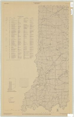
- Subject:
- Topical Subject: Coal mines and mining and Geographic Subject: Indiana
- Creator:
- Hutchison, Harold C. (Harold Christy), 1925-
- Publisher:
- Indiana. Geological Survey
- Date Created:
- 1970
- Identifier:
- VAC3073-M-00965
- Genre:
- Mine maps
- Geographic Location:
- Coordinates: W0880150 W0862422 N0403746 N0374559
- Related URL:
- Catalog URL: https://iucat.iu.edu/catalog/5046399
- Abstract:
- Blue line print. "Base modified from Indiana Department of Conservation, Geological Survey. Base map of portion of western Indiana, 1951." Includ...
- Call Number:
- G4091 .H9 1970 .H8
- Caption:
- Imprint: [Bloomington, Ind.] : Indiana Dept. of Conservation, Geological Survey, [1970]
- Physical Description:
- Dimensions: 88 x 54 cm and Scale: 1:325,000
- Alternate Identifier:
- Title Control Number: a5046399
- Persistent URL:
- https://purl.dlib.indiana.edu/iudl/images/VAC3073/VAC3073-M-00965
