
Search Constraints
You searched for:
Publisher
Главное управление геодезии и картографии при СНК СССР
Remove constraint Publisher: Главное управление геодезии и картографии при СНК СССР
« Previous |
1 - 100 of 189
|
Next »
Search Results
-
- Description:
- 1938
- Subject:
- Topical Subject: Maps, Geographic Subject: Bol’shoye Ploskoye, and Topical Subject: Soviet Union
- Publisher:
- Главное управление геодезии и картографии при СНК СССР
- Language:
- Russian
- Date Created:
- 1941
- Identifier:
- VAC9619-003537
- Genre:
- Topographic Maps and Military Maps
- Geographic Location:
- Coordinates: 57.5, 35.25, 57.667, 35.5
- Related URL:
- Catalog URL: http://iucat.iu.edu/catalog/5020131 and Download GeoTIFF: https://drive.google.com/file/d/1EeF7OKrRaKRbnTsGiQ8gRl4d03khsSsn/view?usp=sharing
- Abstract:
- Modern area represented: Bolshoye Ploskoye, Tverskaya oblast, Russia
- Call Number:
- GM G7000 s50 .S68 sheet O-36-95-B
- Caption:
- Для служебного пользования
- City:
- Большое Плоское (Bolshoye Ploskoye)
- Copyright Holder:
- No Copyright - United States
- Country:
- СССР (USSR)
- State/Province:
- Калининская область (Kalinin oblast)
- Physical Description:
- Scale: 1:50,000
- Persistent URL:
- http://purl.dlib.indiana.edu/iudl/images/VAC9619/VAC9619-003537
- Provenance:
- Army Map Service Library, Library of Congress International Exchange Division of Maps
-
- Description:
- 1938
- Subject:
- Geographic Subject: Zhilotkovo, Topical Subject: Maps, and Topical Subject: Soviet Union
- Publisher:
- Главное управление геодезии и картографии при СНК СССР
- Language:
- Russian
- Date Created:
- 1941
- Identifier:
- VAC9619-003536
- Genre:
- Military Maps and Topographic Maps
- Geographic Location:
- Coordinates: 57.5, 34, 57.667, 34.25
- Related URL:
- Download GeoTIFF: https://drive.google.com/file/d/1Pe-aFLW2Qa6vUmm_dwALhMl2GYKWwbBC/view?usp=sharing and Catalog URL: http://iucat.iu.edu/catalog/5020131
- Abstract:
- Modern area represented: Жилотково (Zhilotkovo), Tverskaya oblast, Russia
- Call Number:
- GM G7000 s50 .S68 sheet O-36-93-A
- City:
- Жилотково (Zhilotkovo)
- Copyright Holder:
- No Copyright - United States
- Country:
- СССР (USSR)
- State/Province:
- Бологовский район (Bologovsky district), Вышневолоцкий район (Vyshnevolotsky district), and Калининская область (Kalinin oblast)
- Physical Description:
- Scale: 1:50,000
- Persistent URL:
- http://purl.dlib.indiana.edu/iudl/images/VAC9619/VAC9619-003536
- Provenance:
- DMA Topographic Center, Army Map Service Library, OMAHA, Library of Congress Geography & Map Division
-
- Description:
- 1939
- Subject:
- Topical Subject: Maps, Geographic Subject: Kostruble, and Topical Subject: Soviet Union
- Publisher:
- Главное управление геодезии и картографии при СНК СССР
- Language:
- Russian
- Date Created:
- 1941
- Identifier:
- VAC9619-003535
- Genre:
- Topographic Maps and Military Maps
- Geographic Location:
- Coordinates: 57.3333, 33.5, 57.5, 33.75
- Related URL:
- Catalog URL: http://iucat.iu.edu/catalog/5020131 and Download GeoTIFF: https://drive.google.com/file/d/1QDlMGkmv8VYRkMLbUljh11YMjbuAlbNM/view?usp=sharing
- Abstract:
- Modern area represented: Кострубле (Kostruble), Tverskaya oblast, Russia
- Call Number:
- GM G7000 s50 .S68 sheet O-36-92-C
- Caption:
- Для служебного пользования
- City:
- Каструбли (Kastrubli)
- Copyright Holder:
- No Copyright - United States
- Country:
- СССР (USSR)
- State/Province:
- Фировский район (Firovsky district), Калининская область (Kalinin oblast), and Осташковский район (Ostashkovsky district)
- Physical Description:
- Scale: 1:50,000
- Persistent URL:
- http://purl.dlib.indiana.edu/iudl/images/VAC9619/VAC9619-003535
- Provenance:
- DMA Topographic Center, Army Map Service Library, OMAHA, Library of Congress Geography & Map Division
-

- Description:
- 1938
- Subject:
- Geographic Subject: Nalyuchi, Topical Subject: Soviet Union, and Topical Subject: Maps
- Publisher:
- Главное управление геодезии и картографии при СНК СССР
- Language:
- Russian
- Date Created:
- 1940
- Identifier:
- VAC9619-003525
- Genre:
- Military Maps and Topographic Maps
- Geographic Location:
- Coordinates: 57.66667, 31.75, 57.83333, 32.0
- Related URL:
- Download GeoTIFF: https://drive.google.com/file/d/1sFselxWPujPodWUqJlqPIV8m91n3gL0P/view?usp=sharing and Catalog URL: http://iucat.iu.edu/catalog/5020131
- Abstract:
- Modern area represented: Налючи (Nalyuchi), Novgorodskaya oblast, Russia
- Call Number:
- GM G7000 s50 .S68 sheet O-36-76-D
- Caption:
- Для служебного пользования
- City:
- Налючи (Nalyuchi)
- Copyright Holder:
- No Copyright - United States
- Country:
- СССР (USSR)
- State/Province:
- Лычковский район (Lychkovsky district), Старорусский район (Starorussky district), Демянский район (Demyansky district), Ленинградская область (Leningrad obl...
- Physical Description:
- Scale: 1:50,000
- Persistent URL:
- http://purl.dlib.indiana.edu/iudl/images/VAC9619/VAC9619-003525
- Provenance:
- DMA Topographic Center, Army Map Service Library, OMAHA, Library of Congress Geography & Map Division
-
- Description:
- 1938
- Subject:
- Geographic Subject: Selikhovo, Topical Subject: Maps, and Topical Subject: Soviet Union
- Publisher:
- Главное управление геодезии и картографии при СНК СССР
- Language:
- Russian
- Date Created:
- 1941
- Identifier:
- VAC9619-003523
- Genre:
- Topographic Maps and Military Maps
- Geographic Location:
- Coordinates: 56.5, 36.75, 56.667, 37
- Related URL:
- Catalog URL: http://iucat.iu.edu/catalog/5020131 and Download GeoTIFF: https://drive.google.com/file/d/1rCotVjjaQLPnjUbK9attztcgGVRXarAQ/view?usp=sharing
- Abstract:
- Modern area represented: Селихово (Selikhovo), Tverskaya oblast, Russia
- Call Number:
- GM G7000 s50 .S68 sheet O-37-122-B
- City:
- Селехово (Selekhovo)
- Copyright Holder:
- No Copyright - United States
- Country:
- СССР (USSR)
- State/Province:
- Калининская область (Kalinin oblast), Клинский район (Klinsky district), Московская область (Moscow oblast), Конаковский район (Konakovsky district), and Зав...
- Physical Description:
- Scale: 1:50,000
- Persistent URL:
- http://purl.dlib.indiana.edu/iudl/images/VAC9619/VAC9619-003523
- Provenance:
- DMA Topographic Center, Army Map Service Library, OMAHA, Library of Congress Geography & Map Division
-
- Description:
- 1938
- Subject:
- Topical Subject: Maps, Topical Subject: Soviet Union, and Geographic Subject: Klin
- Publisher:
- Главное управление геодезии и картографии при СНК СССР
- Language:
- Russian
- Date Created:
- 1941
- Identifier:
- VAC9619-003517
- Genre:
- Topographic Maps and Military Maps
- Geographic Location:
- Coordinates: 56.167, 36.5, 56.333, 36.75
- Related URL:
- Catalog URL: http://iucat.iu.edu/catalog/5020131 and Download GeoTIFF: https://drive.google.com/file/d/1ZMLM09iyeI7_y2lx4RQCcTHNIRjBbZTL/view?usp=sharing
- Abstract:
- Modern area represented: Klin, Russia
- Call Number:
- GM G7000 s50 .S68 sheet O-37-134-A
- City:
- Клин (Klin)
- Copyright Holder:
- No Copyright - United States
- Country:
- СССР (USSR)
- State/Province:
- Солнечногорский район (Solnechnogorsky district), Московская область (Moscow oblast), and Клинский район (Klinsky district)
- Physical Description:
- Scale: 1:50,000
- Persistent URL:
- http://purl.dlib.indiana.edu/iudl/images/VAC9619/VAC9619-003517
- Provenance:
- DMA Topographic Center, Army Map Service Library, Library of Congress Geography & Map Division
-
- Description:
- 1938
- Subject:
- Topical Subject: Maps, Geographic Subject: Denkovo, and Topical Subject: Soviet Union
- Publisher:
- Главное управление геодезии и картографии при СНК СССР
- Language:
- Russian
- Date Created:
- 1941
- Identifier:
- VAC9619-003516
- Genre:
- Topographic Maps and Military Maps
- Geographic Location:
- Coordinates: 56, 36.25, 56.167, 36.5
- Related URL:
- Catalog URL: http://iucat.iu.edu/catalog/5020131 and Download GeoTIFF: https://drive.google.com/file/d/15_6DpZjY9YjpGrhF-Le1L8fdxmap_zTB/view?usp=sharing
- Abstract:
- Modern area represented: Denkovo, Russia
- Call Number:
- GM G7000 s50 .S68 sheet O-37-133-D
- City:
- Деньково (Denkovo)
- Copyright Holder:
- No Copyright - United States
- Country:
- СССР (USSR)
- State/Province:
- Волоколамский район (Volokolamsky district), Клинский район (Klinsky district), Ново-Петровский (Novopetrovsky district), and Московская область (Moscow oblast)
- Physical Description:
- Scale: 1:50,000
- Persistent URL:
- http://purl.dlib.indiana.edu/iudl/images/VAC9619/VAC9619-003516
- Provenance:
- DMA Topographic Center, Army Map Service Library, Library of Congress Geography & Map Division
-
- Subject:
- Geographic Subject: Teryayevo, Topical Subject: Soviet Union, and Topical Subject: Maps
- Publisher:
- Главное управление геодезии и картографии при СНК СССР
- Language:
- Russian
- Date Created:
- 1941
- Identifier:
- VAC9619-003515
- Genre:
- Topographic Maps and Military Maps
- Geographic Location:
- Coordinates: 56.167, 36, 56.333, 36.25
- Related URL:
- Download GeoTIFF: https://drive.google.com/file/d/10M8uz-wV7Uejy6zTPeWDdLEvJ1CG2-O-/view?usp=sharing and Catalog URL: http://iucat.iu.edu/catalog/5020131
- Abstract:
- Modern area represented: Теряево (Teryayevo), Moscow oblast, Russia
- Call Number:
- GM G7000 s50 .S68 sheet O-37-133-A
- City:
- Теряева Слобода (Teryayeva Sloboda)
- Copyright Holder:
- No Copyright - United States
- Country:
- СССР (USSR)
- State/Province:
- Волоколамский район (Volokolamsky district), Клинский район (Klinsky district), Московская область (Moscow oblast), and Лотошинский район (Lotoshinsky district)
- Physical Description:
- Scale: 1:50,000
- Persistent URL:
- http://purl.dlib.indiana.edu/iudl/images/VAC9619/VAC9619-003515
- Provenance:
- DMA Topographic Center, Army Map Service Library, Library of Congress Geography & Map Division
-
- Description:
- 1938
- Subject:
- Topical Subject: Maps, Topical Subject: Soviet Union, and Geographic Subject: Sloboda
- Publisher:
- Главное управление геодезии и картографии при СНК СССР
- Language:
- Russian
- Date Created:
- 1941
- Identifier:
- VAC9619-003514
- Genre:
- Topographic Maps and Military Maps
- Geographic Location:
- Coordinates: 56.333, 36.75, 56.5, 37
- Related URL:
- Download GeoTIFF: https://drive.google.com/file/d/1FIM5aUANKvW41Va_K16TJ3TTeA1rgXmo/view?usp=sharing and Catalog URL: http://iucat.iu.edu/catalog/5020131
- Abstract:
- Modern area represented: Sloboda, Russia
- Call Number:
- GM G7000 s50 .S68 sheet O-37-122-D
- City:
- Слобода (Sloboda)
- Copyright Holder:
- No Copyright - United States
- Country:
- СССР (USSR)
- State/Province:
- Солнечногорский район (Solnechnogorsky district), Клинский район (Klinsky district), and Московская область (Moscow oblast)
- Physical Description:
- Scale: 1:50,000
- Persistent URL:
- http://purl.dlib.indiana.edu/iudl/images/VAC9619/VAC9619-003514
- Provenance:
- DMA Topographic Center, Army Map Service Library, OMAHA, Library of Congress Geography & Map Division
-
- Description:
- 1938
- Subject:
- Topical Subject: Maps, Geographic Subject: Lotoshino, and Topical Subject: Soviet Union
- Publisher:
- Главное управление геодезии и картографии при СНК СССР
- Language:
- Russian
- Identifier:
- VAC9619-003513
- Genre:
- Military Maps and Topographic Maps
- Geographic Location:
- Coordinates: 56.16667, 35.5, 56.3333, 35.75
- Related URL:
- Catalog URL: http://iucat.iu.edu/catalog/5020131 and Download GeoTIFF: https://drive.google.com/file/d/1i9z2n6LOhMgptbpD9qBYj2kH_3jl_3Ec/view?usp=sharing
- Abstract:
- Modern area represented: Лотошино (Lotoshino), Moscow oblast, Russia
- Call Number:
- GM G7000 s50 .S68 sheet O-36-144-A
- City:
- Лотошино (Lotoshino)
- Copyright Holder:
- No Copyright - United States
- Country:
- СССР (USSR)
- State/Province:
- Московская область (Moscow oblast), Старицкий район (Staritsky district), Волоколамский район (Volokolamsky district), Шаховской район (Shakhovsky district),...
- Physical Description:
- Scale: 1:50,000
- Persistent URL:
- http://purl.dlib.indiana.edu/iudl/images/VAC9619/VAC9619-003513
- Provenance:
- DMA Topographic Center, Army Map Service Library, Library of Congress Geography & Map Division
-

- Description:
- 1939
- Subject:
- Geographic Subject: Gorodkovo, Topical Subject: Soviet Union, and Topical Subject: Maps
- Publisher:
- Главное управление геодезии и картографии при СНК СССР
- Language:
- Russian
- Date Created:
- 1941
- Identifier:
- VAC9619-003512
- Genre:
- Topographic Maps and Military Maps
- Geographic Location:
- Coordinates: 56.0, 35.25, 56.16667, 35.5
- Related URL:
- Download GeoTIFF: https://drive.google.com/file/d/1Ac04NnRe-NzKr_Rd_4abwOlEUVYMcFWL/view?usp=sharing and Catalog URL: http://iucat.iu.edu/catalog/5020131
- Abstract:
- Modern area represented: Городково (Gorodkovo), Moscow oblast, Russia
- Call Number:
- GM G7000 s50 .S68 sheet O-36-143-D
- City:
- Городково (Gorodkovo)
- Copyright Holder:
- No Copyright - United States
- Country:
- СССР (USSR)
- State/Province:
- Шаховской район (Shakhovsky district), Калининская область (Kalinin oblast), Московская область (Moscow oblast), and Погорельский район (Pogorelsky district)
- Physical Description:
- Scale: 1:50,000
- Persistent URL:
- http://purl.dlib.indiana.edu/iudl/images/VAC9619/VAC9619-003512
- Provenance:
- DMA Topographic Center, Army Map Service Library, OMAHA, Library of Congress Geography & Map Division
-
- Description:
- 1939
- Subject:
- Geographic Subject: Dorozhayevo, Topical Subject: Soviet Union, and Topical Subject: Maps
- Publisher:
- Главное управление геодезии и картографии при СНК СССР
- Language:
- Russian
- Date Created:
- 1941
- Identifier:
- VAC9619-003511
- Genre:
- Topographic Maps and Military Maps
- Geographic Location:
- Coordinates: 56.16667, 35.25, 56.3333, 35.5
- Related URL:
- Download GeoTIFF: https://drive.google.com/file/d/1QYY6N5qdxxhDk4btYMw4gAtXeeg3jDBr/view?usp=sharing and Catalog URL: http://iucat.iu.edu/catalog/5020131
- Abstract:
- Modern area represented: Дорожаево (Dorozhayevo), Tverskaya oblast, Russia
- Call Number:
- GM G7000 s50 .S68 sheet O-36-143-B
- City:
- Дорожаево (Dorozhayevo)
- Copyright Holder:
- No Copyright - United States
- Country:
- СССР (USSR)
- State/Province:
- Калининская область (Kalinin oblast), Московская область (Moscow oblast), Старицкий район (Staritsky district), Лотошинский район (Lotoshinsky district), Шах...
- Physical Description:
- Scale: 1:50,000
- Persistent URL:
- http://purl.dlib.indiana.edu/iudl/images/VAC9619/VAC9619-003511
- Provenance:
- M. I. Map Library, Library of Congress Geography & Map Division
-
- Description:
- 1939
- Subject:
- Topical Subject: Maps, Topical Subject: Soviet Union, and Geographic Subject: Mozzharino
- Publisher:
- Главное управление геодезии и картографии при СНК СССР
- Language:
- Russian
- Date Created:
- 1941
- Identifier:
- VAC9619-003509
- Genre:
- Topographic Maps and Military Maps
- Geographic Location:
- Coordinates: 56, 34.5, 56.167, 34.75
- Related URL:
- Download GeoTIFF: https://drive.google.com/file/d/1c7-Ks0v5sWqFD0L20fR-lFQ0zbJh_jnU/view?usp=sharing and Catalog URL: http://iucat.iu.edu/catalog/5020131
- Abstract:
- Modern area represented: part of Зубцов (Zubtsov), Tverskaya oblast, Russia
- Call Number:
- GM G7000 s50 .S68 sheet O-36-142-C
- City:
- Мозжарино (Mozzharino)
- Copyright Holder:
- No Copyright - United States
- Country:
- СССР (USSR)
- State/Province:
- РСФСР (RSFSR) and Калининская область (Kalinin oblast)
- Physical Description:
- Scale: 1:50,000
- Persistent URL:
- http://purl.dlib.indiana.edu/iudl/images/VAC9619/VAC9619-003509
- Provenance:
- DMA Topographic Center, Army Map Service Library, OMAHA, Library of Congress Geography & Map Division
-
- Description:
- 1939
- Subject:
- Topical Subject: Soviet Union, Topical Subject: Maps, and Geographic Subject: Yurkino
- Publisher:
- Главное управление геодезии и картографии при СНК СССР
- Language:
- Russian
- Date Created:
- 1941
- Identifier:
- VAC9619-003510
- Genre:
- Topographic Maps and Military Maps
- Geographic Location:
- Coordinates: 56.16667, 35.0, 56.3333, 35.25
- Related URL:
- Download GeoTIFF: https://drive.google.com/file/d/1mhsGnwkBX355A2yvuFsM63nLDR7tOjEP/view?usp=sharing and Catalog URL: http://iucat.iu.edu/catalog/5020131
- Abstract:
- Modern area represented: Юркино (Yurkino), Tverskaya oblast, Russia
- Call Number:
- GM G7000 s50 .S68 sheet O-36-143-A
- Caption:
- Captured map
- City:
- Юркино (Yurkino)
- Copyright Holder:
- No Copyright - United States
- Country:
- СССР (USSR)
- State/Province:
- Калининская область (Kalinin oblast), Погорельский район (Pogorelsky district), and Старицкий район (Staritsky district)
- Physical Description:
- Scale: 1:50,000
- Persistent URL:
- http://purl.dlib.indiana.edu/iudl/images/VAC9619/VAC9619-003510
- Provenance:
- Army Map Service Library, OMAHA, Library of Congress Geography & Map Division
-
- Description:
- 1939
- Subject:
- Topical Subject: Maps, Topical Subject: Soviet Union, and Geographic Subject: Nikiforovskoye
- Publisher:
- Главное управление геодезии и картографии при СНК СССР
- Language:
- Russian
- Date Created:
- 1941
- Identifier:
- VAC9619-003508
- Genre:
- Military Maps and Topographic Maps
- Geographic Location:
- Coordinates: 56.167, 34.75, 56.333, 35
- Related URL:
- Catalog URL: http://iucat.iu.edu/catalog/5020131 and Download GeoTIFF: https://drive.google.com/file/d/14gDli5M_EfZMq68zOWwoAldVf4cw81U9/view?usp=sharing
- Abstract:
- Modern area represented: Никифоровское (Nikiforovskoye), Tverskaya oblast, Russia
- Call Number:
- GM G7000 s50 .S68 sheet O-36-142-B
- City:
- Никифоровское (Nikiforovskoye)
- Copyright Holder:
- No Copyright - United States
- Country:
- СССР (USSR)
- State/Province:
- Калининская область (Kalinin oblast), Погорельский район (Pogorelsky district), Зубцовский район (Zubtsovsky district), and Старицкий район (Staritsky district)
- Physical Description:
- Scale: 1:50,000
- Persistent URL:
- http://purl.dlib.indiana.edu/iudl/images/VAC9619/VAC9619-003508
- Provenance:
- DMA Topographic Center, Army Map Service Library, OMAHA, Library of Congress Geography & Map Division
-
- Description:
- 1938
- Subject:
- Topical Subject: Maps, Geographic Subject: Khlystovo, and Topical Subject: Soviet Union
- Publisher:
- Главное управление геодезии и картографии при СНК СССР
- Language:
- Russian
- Date Created:
- 1941
- Identifier:
- VAC9619-003507
- Genre:
- Topographic Maps and Military Maps
- Geographic Location:
- Coordinates: 56, 33.75, 56.167, 34
- Related URL:
- Download GeoTIFF: https://drive.google.com/file/d/1fGG2lobcB7qv87HgHV3b9IjcaiO1TFwo/view?usp=sharing and Catalog URL: http://iucat.iu.edu/catalog/5020131
- Abstract:
- Modern area represented: Хлыстово (Khlystovo), Tverskaya oblast, Russia
- Call Number:
- GM G7000 s50 .S68 sheet O-36-140-D
- Caption:
- Captured map
- City:
- Хлыстово (Khlystovo)
- Copyright Holder:
- No Copyright - United States
- Country:
- СССР (USSR)
- State/Province:
- Оленинский район (Oleninsky district), Смоленская область (Smolensk oblast), Сычевский район (Sychevsky district), Калининская область (Kalinin oblast), and ...
- Physical Description:
- Scale: 1:50,000
- Persistent URL:
- http://purl.dlib.indiana.edu/iudl/images/VAC9619/VAC9619-003507
- Provenance:
- DMA Topographic Center, Army Map Service Library, Library of Congress Geography & Map Division
-
- Description:
- 1938
- Subject:
- Topical Subject: Soviet Union, Topical Subject: Maps, and Geographic Subject: Novoselki
- Publisher:
- Главное управление геодезии и картографии при СНК СССР
- Language:
- Russian
- Date Created:
- 1941
- Identifier:
- VAC9619-003506
- Genre:
- Military Maps and Topographic Maps
- Geographic Location:
- Coordinates: 56, 33.5, 56.167, 33.75
- Related URL:
- Catalog URL: http://iucat.iu.edu/catalog/5020131 and Download GeoTIFF: https://drive.google.com/file/d/1vVOP92j0feg7jZkHpknICQM830yuWRdh/view?usp=sharing
- Abstract:
- Modern area represented: Новоселки (Novoselki), Tverskaya oblast, Russia
- Call Number:
- GM G7000 s50 .S68 sheet O-36-140-C
- City:
- Новоселки (Novoselki)
- Copyright Holder:
- No Copyright - United States
- Country:
- СССР (USSR)
- State/Province:
- Калининская область (Kalinin oblast) and Оленинский район (Oleninsky district)
- Physical Description:
- Scale: 1:50,000
- Persistent URL:
- http://purl.dlib.indiana.edu/iudl/images/VAC9619/VAC9619-003506
- Provenance:
- DMA Topographic Center, Army Map Service Library, OMAHA
-
- Description:
- 1939
- Subject:
- Geographic Subject: Sady, Topical Subject: Maps, and Topical Subject: Soviet Union
- Publisher:
- Главное управление геодезии и картографии при СНК СССР
- Language:
- Russian
- Date Created:
- 1941
- Identifier:
- VAC9619-003505
- Genre:
- Military Maps and Topographic Maps
- Geographic Location:
- Coordinates: 56.167, 33.5, 56.333, 33.75
- Related URL:
- Download GeoTIFF: https://drive.google.com/file/d/1fm8wOb5L79SO_B23TV6HYKZHDDp9tWLv/view?usp=sharing and Catalog URL: http://iucat.iu.edu/catalog/5020131
- Abstract:
- Modern area represented: Сады (Sady), Tverskaya oblast, Russia
- Call Number:
- GM G7000 s50 .S68 sheet O-36-140-A
- Caption:
- Captured map
- City:
- Сады (Sady)
- Copyright Holder:
- No Copyright - United States
- Country:
- СССР (USSR)
- State/Province:
- Оленинский район (Oleninsky district), Калининская область (Kalinin oblast), and Молодотудский район (Molodotudsky district)
- Physical Description:
- Scale: 1:50,000
- Persistent URL:
- http://purl.dlib.indiana.edu/iudl/images/VAC9619/VAC9619-003505
- Provenance:
- DMA Topographic Center, Army Map Service Library, OMAHA, Library of Congress Geography & Map Division
-
- Description:
- 1939
- Subject:
- Geographic Subject: Olenino, Topical Subject: Maps, and Topical Subject: Soviet Union
- Publisher:
- Главное управление геодезии и картографии при СНК СССР
- Language:
- Russian
- Date Created:
- 1941
- Identifier:
- VAC9619-003503
- Genre:
- Military Maps and Topographic Maps
- Geographic Location:
- Coordinates: 56.167, 33.25, 56.333, 33.5
- Related URL:
- Download GeoTIFF: https://drive.google.com/file/d/14VfwnsGlRiwDLRroFLvT-YtlQlOdMpvz/view?usp=sharing and Catalog URL: http://iucat.iu.edu/catalog/5020131
- Abstract:
- Modern area represented: Оленино (Olenino), Tverskaya oblast, Russia
- Call Number:
- GM G7000 s50 .S68 sheet O-36-139-B
- City:
- Оленино (Olenino)
- Copyright Holder:
- No Copyright - United States
- Country:
- СССР (USSR)
- State/Province:
- Оленинский район (Oleninsky district) and Калининская область (Kalinin oblast)
- Physical Description:
- Scale: 1:50,000
- Persistent URL:
- http://purl.dlib.indiana.edu/iudl/images/VAC9619/VAC9619-003503
- Provenance:
- DMA Topographic Center, Army Map Service Library, OMAHA, Library of Congress Geography & Map Division
-
- Description:
- 1938
- Subject:
- Geographic Subject: Feryazkino, Topical Subject: Soviet Union, and Topical Subject: Maps
- Publisher:
- Главное управление геодезии и картографии при СНК СССР
- Language:
- Russian
- Date Created:
- 1941
- Identifier:
- VAC9619-003478
- Genre:
- Topographic Maps and Military Maps
- Geographic Location:
- Coordinates: 56.333, 35.75, 56.5, 36
- Related URL:
- Catalog URL: http://iucat.iu.edu/catalog/5020131 and Download GeoTIFF: https://drive.google.com/file/d/17W365JTid2GpJ9Vsdxn-jOk35JchUcHB/view?usp=sharing
- Abstract:
- Modern area represented: Ферязкино (Feryazkino), Tverskaya oblast, Russia
- Call Number:
- G7000 s50 .S68 sheet O-36-132-D
- City:
- Большое Ферязкино (Bol’shoye Feryazkino)
- Copyright Holder:
- No Copyright - United States
- Country:
- СССР (USSR)
- State/Province:
- Лотошинский район (Lotoshinsky district), Московская область (Moscow oblast), Калининская область (Kalinin oblast), and Тургиновский район (Turginovsky distr...
- Physical Description:
- Scale: 1:50,000
- Persistent URL:
- http://purl.dlib.indiana.edu/iudl/images/VAC9619/VAC9619-003478
- Provenance:
- DMA Topographic Center, Army Map Service Library, Library of Congress Geography & Map Division
-
- Description:
- 1938
- Subject:
- Geographic Subject: Rodnya, Topical Subject: Soviet Union, and Topical Subject: Maps
- Publisher:
- Главное управление геодезии и картографии при СНК СССР
- Language:
- Russian
- Date Created:
- 1941
- Identifier:
- VAC9619-003477
- Genre:
- Military Maps and Topographic Maps
- Geographic Location:
- Coordinates: 56.333, 34.75, 56.5, 35
- Related URL:
- Catalog URL: http://iucat.iu.edu/catalog/5020131 and Download GeoTIFF: https://drive.google.com/file/d/1REcEYzS-IqtvOX9vkRyhRwVimhCOaQL-/view?usp=sharing
- Abstract:
- Modern area represented: Родня (Rodnya), Tverskaya oblast, Russia
- Call Number:
- G7000 s50 .S68 sheet O-36-130-D
- City:
- Родня (Rodnya)
- Copyright Holder:
- No Copyright - United States
- Country:
- СССР (USSR)
- State/Province:
- Калининская область (Kalinin oblast), Старицкий район (Staritsky district), and Зубцовский район (Zubtsovsky district)
- Physical Description:
- Scale: 1:50,000
- Persistent URL:
- http://purl.dlib.indiana.edu/iudl/images/VAC9619/VAC9619-003477
- Provenance:
- DMA Topographic Center, Army Map Service Library, OMAHA, Library of Congress Geography & Map Division
-
- Description:
- 1938
- Subject:
- Topical Subject: Soviet Union, Geographic Subject: Staritsa, and Topical Subject: Maps
- Publisher:
- Главное управление геодезии и картографии при СНК СССР
- Language:
- Russian
- Date Created:
- 1941
- Identifier:
- VAC9619-003476
- Genre:
- Topographic Maps and Military Maps
- Geographic Location:
- Coordinates: 56.5, 34.75, 56.667, 35
- Related URL:
- Download GeoTIFF: https://drive.google.com/file/d/1Ffo_UO7HIdQS1iN83jJIlQTlyLKvURbA/view?usp=sharing and Catalog URL: http://iucat.iu.edu/catalog/5020131
- Abstract:
- Modern area represented: Старица (Staritsa), Tverskaya oblast, Russia
- Call Number:
- G7000 s50 .S68 sheet O-36-130-B
- City:
- Старица (Staritsa)
- Copyright Holder:
- No Copyright - United States
- Country:
- СССР (USSR)
- State/Province:
- Высоковский район (Vysokovsky district), Калининская область (Kalinin oblast), and Старицкий район (Staritsky district)
- Physical Description:
- Scale: 1:50,000
- Persistent URL:
- http://purl.dlib.indiana.edu/iudl/images/VAC9619/VAC9619-003476
- Provenance:
- DMA Topographic Center, Army Map Service Library, OMAHA, Library of Congress Geography & Map Division
-
- Description:
- 1938
- Subject:
- Topical Subject: Maps, Geographic Subject: Plotnikovo, and Topical Subject: Soviet Union
- Publisher:
- Главное управление геодезии и картографии при СНК СССР
- Language:
- Russian
- Date Created:
- 1941
- Identifier:
- VAC9619-003474
- Genre:
- Military Maps and Topographic Maps
- Geographic Location:
- Coordinates: 56.333, 34.25, 56.5, 34.5
- Related URL:
- Catalog URL: http://iucat.iu.edu/catalog/5020131 and Download GeoTIFF: https://drive.google.com/file/d/1rtSI05x2OGdyNyY9GkpIk8olI5V_zoPE/view?usp=sharing
- Abstract:
- Modern area represented: Плотниково (Plotnikovo), Tverskaya oblast, Russia
- Call Number:
- G7000 s50 .S68 sheet O-36-129-D
- City:
- Плотниково (Plotnikovo)
- Copyright Holder:
- No Copyright - United States
- Country:
- СССР (USSR)
- State/Province:
- Ржевский район (Rzhevsky district), Калининская область (Kalinin oblast), and Луковниковский район (Lukovnikovsky district)
- Physical Description:
- Scale: 1:50,000
- Persistent URL:
- http://purl.dlib.indiana.edu/iudl/images/VAC9619/VAC9619-003474
- Provenance:
- DMA Topographic Center, Army Map Service Library, OMAHA, Library of Congress Geography & Map Division
-

- Description:
- 1938
- Subject:
- Geographic Subject: Ramen'ye, Topical Subject: Soviet Union, and Topical Subject: Maps
- Publisher:
- Главное управление геодезии и картографии при СНК СССР
- Language:
- Russian
- Date Created:
- 1941
- Identifier:
- VAC9619-003473
- Genre:
- Topographic Maps and Military Maps
- Geographic Location:
- Coordinates: 56.333, 34, 56.5, 34.25
- Related URL:
- Download GeoTIFF: https://drive.google.com/file/d/1qh-E-lgJptpwG6nUxUBiR_gBwnFCrbrW/view?usp=sharing and Catalog URL: http://iucat.iu.edu/catalog/5020131
- Abstract:
- Modern area represented: Раменье (Ramen'ye), Tverskaya oblast, Russia
- Call Number:
- G7000 s50 .S68 sheet O-36-129-C
- City:
- Раменье (Ramen'ye)
- Copyright Holder:
- No Copyright - United States
- Country:
- СССР (USSR)
- State/Province:
- Луковниковский район (Lukovnikovsky district), Калининская область (Kalinin oblast), Молодотудский район (Molodotudsky district), and Ржевский район (Rzhevsk...
- Physical Description:
- Scale: 1:50,000
- Persistent URL:
- http://purl.dlib.indiana.edu/iudl/images/VAC9619/VAC9619-003473
- Provenance:
- DMA Topographic Center, Army Map Service Library, OMAHA, Library of Congress Geography & Map Division
-
- Description:
- 1938
- Subject:
- Topical Subject: Maps, Geographic Subject: Pavlikovo, and Topical Subject: Soviet Union
- Publisher:
- Главное управление геодезии и картографии при СНК СССР
- Language:
- Russian
- Date Created:
- 1941
- Identifier:
- VAC9619-003472
- Genre:
- Topographic Maps and Military Maps
- Geographic Location:
- Coordinates: 56.5, 34.25, 56.667, 34.5
- Related URL:
- Download GeoTIFF: https://drive.google.com/file/d/1cM86uH12YBkYFhQNZjwCtN7j02FCIzUX/view?usp=sharing and Catalog URL: http://iucat.iu.edu/catalog/5020131
- Abstract:
- Modern area represented: Павликово (Pavlikovo), Tverskaya oblast, Russia
- Call Number:
- G7000 s50 .S68 sheet O-36-129-B
- City:
- Павликово (Pavlikovo)
- Copyright Holder:
- No Copyright - United States
- Country:
- СССР (USSR)
- State/Province:
- Луковниковский район (Lukovnikovsky district) and Калининская область (Kalinin oblast)
- Physical Description:
- Scale: 1:50,000
- Persistent URL:
- http://purl.dlib.indiana.edu/iudl/images/VAC9619/VAC9619-003472
- Provenance:
- M. I. Map Library, Library of Congress Geography & Map Division
-
- Description:
- 1939
- Subject:
- Geographic Subject: Okovtsy, Topical Subject: Maps, and Topical Subject: Soviet Union
- Publisher:
- Главное управление геодезии и картографии при СНК СССР
- Language:
- Russian
- Date Created:
- 1941
- Identifier:
- VAC9619-003471
- Genre:
- Topographic Maps and Military Maps
- Geographic Location:
- Coordinates: 56.5, 33.25, 56.667, 33.5
- Related URL:
- Download GeoTIFF: https://drive.google.com/file/d/1QrCmf9strde4Q_XXo1Oe5tCoJFq2VFP6/view?usp=sharing and Catalog URL: http://iucat.iu.edu/catalog/5020131
- Abstract:
- Modern area represented: Оковцы (Okovtsy), Tverskaya oblast, Russia
- Call Number:
- G7000 s50 .S68 sheet O-36-127-B
- City:
- Оковцы (Okovtsy)
- Copyright Holder:
- No Copyright - United States
- Country:
- СССР (USSR)
- State/Province:
- Кировский район (Kirov district), Молодотудский район (Molodotudsky district), and Калининская область (Kalinin oblast)
- Physical Description:
- Scale: 1:50,000
- Persistent URL:
- http://purl.dlib.indiana.edu/iudl/images/VAC9619/VAC9619-003471
- Provenance:
- DMA Topographic Center, Army Map Service Library, OMAHA, Library of Congress Geography & Map Division
-
- Description:
- 1939
- Subject:
- Topical Subject: Soviet Union, Geographic Subject: Vysokoye, and Topical Subject: Maps
- Publisher:
- Главное управление геодезии и картографии при СНК СССР
- Language:
- Russian
- Date Created:
- 1941
- Identifier:
- VAC9619-003470
- Genre:
- Topographic Maps and Military Maps
- Geographic Location:
- Coordinates: 56.333, 32.75, 56.5, 33
- Related URL:
- Download GeoTIFF: https://drive.google.com/file/d/12E5i-f2khtKqePPSxPnAOJT4oAAmYPRD/view?usp=sharing and Catalog URL: http://iucat.iu.edu/catalog/5020131
- Abstract:
- Modern area represented: Высокое (Vysokoye), Tverskaya oblast, Russia
- Call Number:
- G7000 s50 .S68 sheet O-36-126-D
- City:
- Высокое (Vysokoye)
- Copyright Holder:
- No Copyright - United States
- Country:
- СССР (USSR)
- State/Province:
- Нелидовский район (Nelidovsky district), Ленинский район (Leninsky district), Молодотудский район (Molodotudsky district), and Калининская область (Kalinin o...
- Physical Description:
- Scale: 1:50,000
- Persistent URL:
- http://purl.dlib.indiana.edu/iudl/images/VAC9619/VAC9619-003470
- Provenance:
- DMA Topographic Center, Army Map Service Library, OMAHA, Library of Congress Geography & Map Division
-
- Description:
- 1939
- Subject:
- Topical Subject: Maps, Topical Subject: Soviet Union, and Geographic Subject: Grylevo
- Publisher:
- Главное управление геодезии и картографии при СНК СССР
- Language:
- Russian
- Date Created:
- 1941
- Identifier:
- VAC9619-003469
- Genre:
- Military Maps and Topographic Maps
- Geographic Location:
- Coordinates: 56.5, 32.75, 56.667, 33
- Related URL:
- Download GeoTIFF: https://drive.google.com/file/d/1QjGmO0DeaIwByion1ZVfgkNgLjktqFbW/view?usp=sharing and Catalog URL: http://iucat.iu.edu/catalog/5020131
- Abstract:
- Modern area represented: Грылево (Grylevo), Tverskaya oblast, Russia
- Call Number:
- G7000 s50 .S68 sheet O-36-126-B
- City:
- Грылево (Grylevo)
- Copyright Holder:
- No Copyright - United States
- Country:
- СССР (USSR)
- State/Province:
- Пеновский район (Penovsky district), Ленинский район (Leninsky district), Калининская область (Kalinin oblast), and Молодотудский район (Molodotudsky district)
- Physical Description:
- Scale: 1:50,000
- Persistent URL:
- http://purl.dlib.indiana.edu/iudl/images/VAC9619/VAC9619-003469
- Provenance:
- Army Map Service Library, OMAHA
-
- Description:
- 1939
- Subject:
- Geographic Subject: Il’yushino, Topical Subject: Maps, and Topical Subject: Soviet Union
- Publisher:
- Главное управление геодезии и картографии при СНК СССР
- Language:
- Russian
- Date Created:
- 1941
- Identifier:
- VAC9619-003468
- Genre:
- Military Maps and Topographic Maps
- Geographic Location:
- Coordinates: 56.333, 32.5, 56.5, 32.75
- Related URL:
- Catalog URL: http://iucat.iu.edu/catalog/5020131 and Download GeoTIFF: https://drive.google.com/file/d/1gFCKXL3LEEV_HoW5baG2udOZMvB2T_-c/view?usp=sharing
- Abstract:
- Modern area represented: Ильюшино (Il’yushino), Tverskaya oblast, Russia
- Call Number:
- G7000 s50 .S68 sheet O-36-126-C
- City:
- Ильюшино (Il’yushino)
- Copyright Holder:
- No Copyright - United States
- Country:
- СССР (USSR)
- State/Province:
- Нелидовский район (Nelidovsky district), Калининская область (Kalinin oblast), and Ленинский район (Leninsky district)
- Physical Description:
- Scale: 1:50,000
- Persistent URL:
- http://purl.dlib.indiana.edu/iudl/images/VAC9619/VAC9619-003468
- Provenance:
- M. I. Map Library, Library of Congress Geography & Map Division
-
- Description:
- 1939
- Subject:
- Geographic Subject: Mozhayevo, Topical Subject: Soviet Union, and Topical Subject: Maps
- Publisher:
- Главное управление геодезии и картографии при СНК СССР
- Language:
- Russian
- Date Created:
- 1941
- Identifier:
- VAC9619-003467
- Genre:
- Military Maps and Topographic Maps
- Geographic Location:
- Coordinates: 56.5, 32.5, 56.667, 32.75
- Related URL:
- Download GeoTIFF: https://drive.google.com/file/d/1DmpxDqo31t3uRO5WexL_6pIauKcw7TJS/view?usp=sharing and Catalog URL: http://iucat.iu.edu/catalog/5020131
- Abstract:
- Modern area represented: Можаево (Mozhayevo), Tverskaya oblast, Russia
- Call Number:
- G7000 s50 .S68 sheet O-36-126-A
- City:
- Можаево (Mozhayevo)
- Copyright Holder:
- No Copyright - United States
- Country:
- СССР (USSR)
- State/Province:
- Нелидовский район (Nelidovsky district), Пеновский район (Penovsky district), Ленинский район (Leninsky district), and Калининская область (Kalinin oblast)
- Physical Description:
- Scale: 1:50,000
- Persistent URL:
- http://purl.dlib.indiana.edu/iudl/images/VAC9619/VAC9619-003467
- Provenance:
- DMA Topographic Center, Army Map Service Library, OMAHA, Library of Congress Geography & Map Division
-
- Description:
- 1939
- Subject:
- Topical Subject: Maps, Geographic Subject: Luk’yanovo, and Topical Subject: Soviet Union
- Publisher:
- Главное управление геодезии и картографии при СНК СССР
- Language:
- Russian
- Date Created:
- 1941
- Identifier:
- VAC9619-003466
- Genre:
- Military Maps and Topographic Maps
- Geographic Location:
- Coordinates: 56.333, 31.75, 56.5, 32
- Related URL:
- Catalog URL: http://iucat.iu.edu/catalog/5020131 and Download GeoTIFF: https://drive.google.com/file/d/10v1q0TE_qhlBpBnUD4qgXMRlbV163Z0k/view?usp=sharing
- Abstract:
- Modern area represented: Лукьяново (Luk’yanovo), Tverskaya oblast, Russia
- Call Number:
- GM G7000 s50 .S68 sheet O-36-124-D
- City:
- Лукьяново (Luk’yanovo)
- Copyright Holder:
- No Copyright - United States
- Country:
- СССР (USSR)
- State/Province:
- Октябрьский район (Oktyabrsky district), Ленинский район (Leninsky district), Торопецкий район (Toropetsky district), and Калининская область (Kalinin oblast)
- Physical Description:
- Scale: 1:50,000
- Persistent URL:
- http://purl.dlib.indiana.edu/iudl/images/VAC9619/VAC9619-003466
- Provenance:
- DMA Topographic Center, Army Map Service Library, OMAHA, Library of Congress Geography & Map Division
-
- Description:
- 1939
- Subject:
- Geographic Subject: Rechane, Topical Subject: Maps, and Topical Subject: Soviet Union
- Publisher:
- Главное управление геодезии и картографии при СНК СССР
- Language:
- Russian
- Date Created:
- 1941
- Identifier:
- VAC9619-003465
- Genre:
- Topographic Maps and Military Maps
- Geographic Location:
- Coordinates: 56.333, 31.5, 56.5, 31.75
- Related URL:
- Catalog URL: http://iucat.iu.edu/catalog/5020131 and Download GeoTIFF: https://drive.google.com/file/d/1QB3naAi8lpWvMkd1t_XQZVBu8tcfiGUu/view?usp=sharing
- Abstract:
- Modern area represented: Речане (Rechane), Tverskaya oblast, Russia
- Call Number:
- GM G7000 s50 .S68 sheet O-36-124-C
- Caption:
- Для служебного пользования
- City:
- Речане (Rechane)
- Copyright Holder:
- No Copyright - United States
- Country:
- СССР (USSR)
- State/Province:
- Октябрьский район (Oktyabrsky district), Калининская область (Kalinin oblast), and Торопецкий район (Toropetsky district)
- Physical Description:
- Scale: 1:50,000
- Persistent URL:
- http://purl.dlib.indiana.edu/iudl/images/VAC9619/VAC9619-003465
- Provenance:
- DMA Topographic Center, Army Map Service Library, Geographic Names Branch, Library of Congress Geography & Map Division
-
- Description:
- 1939
- Subject:
- Geographic Subject: Toropets, Topical Subject: Soviet Union, and Topical Subject: Maps
- Publisher:
- Главное управление геодезии и картографии при СНК СССР
- Language:
- Russian
- Identifier:
- VAC9619-003463
- Genre:
- Topographic Maps and Military Maps
- Geographic Location:
- Coordinates: 56.5, 31.5, 56.667, 31.75
- Related URL:
- Download GeoTIFF: https://drive.google.com/file/d/1EASaF8lo6_Fq32YArRd9sCaBlurPVfbV/view?usp=sharing and Catalog URL: http://iucat.iu.edu/catalog/5020131
- Abstract:
- Modern area represented: Торопец (Toropets), Tverskaya oblast, Russia
- Call Number:
- GM G7000 s50 .S68 sheet O-36-124-A
- Caption:
- Для служебного пользования
- City:
- Торопец (Toropets)
- Copyright Holder:
- No Copyright - United States
- Country:
- СССР (USSR)
- State/Province:
- РСФСР (RSFSR) and Калининская область (Kalinin oblast)
- Physical Description:
- Scale: 1:50,000
- Persistent URL:
- http://purl.dlib.indiana.edu/iudl/images/VAC9619/VAC9619-003463
- Provenance:
- DMA Topographic Center, Army Map Service Library, OMAHA, Library of Congress Geography & Map Division
-
- Description:
- 1938
- Subject:
- Topical Subject: Soviet Union, Topical Subject: Maps, and Geographic Subject: Boykovo
- Publisher:
- Главное управление геодезии и картографии при СНК СССР
- Language:
- Russian
- Date Created:
- 1941
- Identifier:
- VAC9619-003447
- Genre:
- Military Maps and Topographic Maps
- Geographic Location:
- Coordinates: 56.833, 35.5, 57, 35.75
- Related URL:
- Download GeoTIFF: https://drive.google.com/file/d/1BdYV5wb7st8BaWASg6uGiYw9j6iroPEA/view?usp=sharing and Catalog URL: http://iucat.iu.edu/catalog/5020131
- Abstract:
- Modern area represented: Бойково (Boykovo), Tverskaya oblast, Russia
- Call Number:
- GM G7000 s50 .S68 sheet O-36-120-A
- City:
- Бойково (Boykovo)
- Copyright Holder:
- No Copyright - United States
- Country:
- СССР (USSR)
- State/Province:
- Медновский район (Mednovsky district), Калининский район (Kalininsky district), and Калининская область (Kalinin oblast)
- Physical Description:
- Scale: 1:50,000
- Persistent URL:
- http://purl.dlib.indiana.edu/iudl/images/VAC9619/VAC9619-003447
- Provenance:
- CIA Map Branch -- Received
-
- Description:
- 1939
- Subject:
- Geographic Subject: Druzhnaya Gorka, Topical Subject: Maps, and Topical Subject: Soviet Union
- Publisher:
- Главное управление геодезии и картографии при СНК СССР
- Language:
- Russian
- Identifier:
- VAC9619-003376
- Genre:
- Topographic Maps and Military Maps
- Geographic Location:
- Coordinates: 58.333, 32.75, 58.5, 33
- Related URL:
- Catalog URL: http://iucat.iu.edu/catalog/5020131 and Download GeoTIFF: https://drive.google.com/file/d/1oGUheQvOXuuLP8IOCN-VUvVMS9T4NRqK/view?usp=sharing
- Abstract:
- Modern area represented: Дружная Горка (Druzhnaya Gorka), Novgorodskaya oblast, Russia
- Call Number:
- G7000 s50 .S68 sheet O-36-54-D
- Caption:
- Для служебного пользования
- City:
- Glupaya Gorka
- Copyright Holder:
- No Copyright - United States
- Country:
- СССР (USSR)
- State/Province:
- Ленинградская область (Leningrad oblast), Окуловский район (Okulovsky district), and Крестецкий район (Krestetsky district)
- Physical Description:
- Scale: 1:50,000
- Persistent URL:
- http://purl.dlib.indiana.edu/iudl/images/VAC9619/VAC9619-003376
- Provenance:
- DMA Topographic Center, Army Map Service Library, OMAHA, Library of Congress Geography & Map Division
-
- Description:
- 1938
- Subject:
- Topical Subject: Soviet Union, Topical Subject: Maps, and Geographic Subject: Budki
- Publisher:
- Главное управление геодезии и картографии при СНК СССР
- Language:
- Russian
- Date Created:
- 1940
- Identifier:
- VAC9619-003375
- Genre:
- Topographic Maps and Military Maps
- Geographic Location:
- Coordinates: 58.333, 32.5, 58.5, 32.75
- Related URL:
- Download GeoTIFF: https://drive.google.com/file/d/1so-14PckiQLb0Gwdnqcm2d8t0g5cumQ-/view?usp=sharing and Catalog URL: http://iucat.iu.edu/catalog/5020131
- Abstract:
- Modern area represented: Будки (Budki), Novgorodskaya oblast, Russia
- Call Number:
- G7000 s50 .S68 sheet O-36-54-C
- Caption:
- Для служебного пользования
- City:
- Будки (Budki)
- Copyright Holder:
- No Copyright - United States
- Country:
- СССР (USSR)
- State/Province:
- Маловишерский район (Malovishersky district), Крестецкий район (Krestetsky district), Ленинградская область (Leningrad oblast), and Окуловский район (Okulovs...
- Physical Description:
- Scale: 1:50,000
- Persistent URL:
- http://purl.dlib.indiana.edu/iudl/images/VAC9619/VAC9619-003375
- Provenance:
- DMA Topographic Center, Army Map Service Library, Library of Congress Geography & Map Division
-
- Description:
- 1939
- Subject:
- Topical Subject: Maps, Geographic Subject: Torbino, and Topical Subject: Soviet Union
- Publisher:
- Главное управление геодезии и картографии при СНК СССР
- Language:
- Russian
- Date Created:
- 1941
- Identifier:
- VAC9619-003374
- Genre:
- Military Maps and Topographic Maps
- Geographic Location:
- Coordinates: 58.5, 32.75, 58.667, 33
- Related URL:
- Download GeoTIFF: https://drive.google.com/file/d/1REcpv4d51hjjI3DlbpCjUEu2PCsUgHsu/view?usp=sharing and Catalog URL: http://iucat.iu.edu/catalog/5020131
- Abstract:
- Modern area represented: Торбино (Torbino), Novgorodskaya oblast, Russia
- Call Number:
- G7000 s50 .S68 sheet O-36-54-B
- Caption:
- Для служебного пользования and Captured map
- City:
- Торбино (Torbino)
- Copyright Holder:
- No Copyright - United States
- Country:
- СССР (USSR)
- State/Province:
- Ленинградская область (Leningrad oblast)
- Physical Description:
- Scale: 1:50,000
- Persistent URL:
- http://purl.dlib.indiana.edu/iudl/images/VAC9619/VAC9619-003374
- Provenance:
- DMA Topographic Center, Army Map Service Library, OMAHA, Library of Congress Geography & Map Division
-
- Description:
- 1938
- Subject:
- Topical Subject: Soviet Union, Topical Subject: Maps, and Geographic Subject: Amosovo
- Publisher:
- Главное управление геодезии и картографии при СНК СССР
- Language:
- Russian
- Date Created:
- 1940
- Identifier:
- VAC9619-003373
- Genre:
- Topographic Maps and Military Maps
- Geographic Location:
- Coordinates: 58.333, 32.25, 58.5, 32.5
- Related URL:
- Catalog URL: http://iucat.iu.edu/catalog/5020131 and Download GeoTIFF: https://drive.google.com/file/d/1mQArnAgEgLtSec-6rCvW8frdDa8N95nb/view?usp=sharing
- Abstract:
- Modern area represented: Амосово (Amosovo), Novgorodskaya oblast, Russia
- Call Number:
- G7000 s50 .S68 sheet O-36-53-D
- Caption:
- Для служебного пользования and Captured map
- City:
- Амосово (Amosovo)
- Copyright Holder:
- No Copyright - United States
- Country:
- СССР (USSR)
- State/Province:
- Крестецкий район (Krestetsky district), Маловишерский район (Malovishersky district), and Ленинградская область (Leningrad oblast)
- Physical Description:
- Scale: 1:50,000
- Persistent URL:
- http://purl.dlib.indiana.edu/iudl/images/VAC9619/VAC9619-003373
- Provenance:
- Army Map Service Library, OMAHA, Library of Congress Geography & Map Division
-
- Description:
- 1938
- Subject:
- Geographic Subject: Dvorishchi, Topical Subject: Soviet Union, and Topical Subject: Maps
- Publisher:
- Главное управление геодезии и картографии при СНК СССР
- Language:
- Russian
- Identifier:
- VAC9619-003371
- Genre:
- Military Maps and Topographic Maps
- Geographic Location:
- Coordinates: 58.5, 32.25, 58.667, 32.5
- Related URL:
- Catalog URL: http://iucat.iu.edu/catalog/5020131 and Download GeoTIFF: https://drive.google.com/file/d/1g824LzZlf3RRWsdzTBr8h7RVARtfdI_k/view?usp=sharing
- Abstract:
- Modern area represented: Дворищи (Dvorishchi), Novgorodskaya oblast, Russia
- Call Number:
- G7000 s50 .S68 sheet O-36-53-B
- Caption:
- Для служебного пользования
- City:
- Дворищи (Dvorishchi)
- Copyright Holder:
- No Copyright - United States
- Country:
- СССР (USSR)
- State/Province:
- Ленинградская область (Leningrad oblast), Маловишерский район (Malovishersky district), and Крестецкий район (Krestetsky district)
- Physical Description:
- Scale: 1:50,000
- Persistent URL:
- http://purl.dlib.indiana.edu/iudl/images/VAC9619/VAC9619-003371
- Provenance:
- M. I. Map Library
-
- Description:
- 1937
- Subject:
- Topical Subject: Soviet Union, Geographic Subject: Lyubolyady, and Topical Subject: Maps
- Publisher:
- Главное управление геодезии и картографии при СНК СССР
- Language:
- Russian
- Date Created:
- 1941
- Identifier:
- VAC9619-003363
- Genre:
- Military Maps and Topographic Maps
- Geographic Location:
- Coordinates: 58.5, 30.75, 58.667, 31
- Related URL:
- Catalog URL: http://iucat.iu.edu/catalog/5020131 and Download GeoTIFF: https://drive.google.com/file/d/1ZDggAdZ_3laR_snLCNc-7jxa2T1MoShO/view?usp=sharing
- Abstract:
- Modern area represented: Люболяды (Lyubolyady), Novgorodskaya oblast, Russia
- Call Number:
- G7000 s50 .S68 sheet O-36-50-B
- Caption:
- Для служебного пользования and Captured map
- City:
- Люболяды (Lyubolyady)
- Copyright Holder:
- No Copyright - United States
- Country:
- СССР (USSR)
- State/Province:
- Новгородский район (Novgorod district), Ленинградская область (Leningrad oblast), РСФСР (RSFSR), and Батецкий район (Batetsky district)
- Physical Description:
- Scale: 1:50,000
- Persistent URL:
- http://purl.dlib.indiana.edu/iudl/images/VAC9619/VAC9619-003363
- Provenance:
- DMA Topographic Center, Army Map Service Library, OMAHA, Library of Congress Geography & Map Division
-
- Description:
- 1940
- Subject:
- Geographic Subject: Rylsk, Topical Subject: Maps, and Topical Subject: Soviet Union
- Publisher:
- Главное управление геодезии и картографии при СНК СССР
- Language:
- Russian
- Date Created:
- 1941
- Identifier:
- VAC9619-003268
- Genre:
- Military Maps and Topographic Maps
- Geographic Location:
- Coordinates: 51.333, 34.5, 51.667, 35
- Related URL:
- Catalog URL: https://iucat.iu.edu/catalog/5020129 and Download GeoTIFF: https://drive.google.com/file/d/17nmbolXXII1wdPqY29439uOYc2Vuo4Bi/view?usp=sharing
- Abstract:
- Modern area represented: Rylsk, Kursk oblast, Russia
- Call Number:
- G7000 s100 .S7 sheet M-36-22
- City:
- Рыльск (Rylsk)
- Copyright Holder:
- No Copyright - United States
- Country:
- СССР (USSR)
- State/Province:
- РСФСР (RSFSR) and Курская область (Kursk oblast)
- Physical Description:
- Scale: 1:100,000
- Persistent URL:
- http://purl.dlib.indiana.edu/iudl/images/VAC9619/VAC9619-003268
- Provenance:
- DMA Topographic Center, Army Map Service Library, OMAHA, Library of Congress Geography & Map Division, Auswärtiges Amt. Geographischer Dienst
-
- Description:
- 1939
- Subject:
- Topical Subject: Soviet Union, Topical Subject: Maps, and Geographic Subject: Voronezh
- Publisher:
- Главное управление геодезии и картографии при СНК СССР
- Language:
- Russian
- Date Created:
- 1941
- Identifier:
- VAC9619-003259
- Genre:
- Topographic Maps and Military Maps
- Geographic Location:
- Coordinates: 51.667, 33, 52, 33.5
- Related URL:
- Catalog URL: https://iucat.iu.edu/catalog/5020129 and Download GeoTIFF: https://drive.google.com/file/d/1wkzHfaQ0hqJWsSKZl0nr7EeOORHorj2j/view?usp=sharing
- Abstract:
- Modern area represented: Voronezh, Sumy oblast, Ukraine
- Call Number:
- G7000 s100 .S7 sheet M-36-7
- City:
- Воронеж (Voronezh)
- Copyright Holder:
- No Copyright - United States
- Country:
- СССР (USSR)
- State/Province:
- Украинская ССР (Ukrainian Soviet Socialist Republic), Сумская область (Sumy oblast), and Черниговская область (Chernihiv oblast)
- Physical Description:
- Scale: 1:100,000
- Persistent URL:
- http://purl.dlib.indiana.edu/iudl/images/VAC9619/VAC9619-003259
- Provenance:
- DMA Topographic Center, Army Map Service Library, OMAHA, Atlasblatt
-
- Description:
- 1938
- Subject:
- Topical Subject: Soviet Union, Topical Subject: Maps, and Geographic Subject: Ponornitsa
- Publisher:
- Главное управление геодезии и картографии при СНК СССР
- Language:
- Russian
- Date Created:
- 1941
- Identifier:
- VAC9619-003258
- Genre:
- Topographic Maps and Military Maps
- Geographic Location:
- Coordinates: 51.667, 32.5, 52, 33
- Related URL:
- Download GeoTIFF: https://drive.google.com/file/d/1jcMqiw4doviC_niimFRwaVdI-Gcl6YTQ/view?usp=sharing and Catalog URL: https://iucat.iu.edu/catalog/5020129
- Abstract:
- Modern area represented: Ponornitsa, Chernihiv oblast, Ukraine
- Call Number:
- G7000 s100 .S7 sheet M-36-6
- City:
- Понорница (Ponornitsa)
- Copyright Holder:
- No Copyright - United States
- Country:
- СССР (USSR)
- State/Province:
- Черниговская область (Chernihiv oblast) and Украинская ССР (Ukrainian Soviet Socialist Republic)
- Physical Description:
- Scale: 1:100,000
- Persistent URL:
- http://purl.dlib.indiana.edu/iudl/images/VAC9619/VAC9619-003258
- Provenance:
- DMA Topographic Center, Army Map Service Library, OMAHA, Auswärtiges Amt. Geographischer Dienst
-
- Description:
- 1938
- Subject:
- Geographic Subject: Kashira, Topical Subject: Maps, and Topical Subject: Soviet Union
- Publisher:
- Главное управление геодезии и картографии при СНК СССР
- Language:
- Russian
- Date Created:
- 1941
- Identifier:
- VAC9619-003101
- Genre:
- Military Maps and Topographic Maps
- Geographic Location:
- Coordinates: 54.667, 38, 55, 38.5
- Related URL:
- Download GeoTIFF: https://drive.google.com/file/d/1yvi6zIZ_VbmjGBIIf9ja_bK-q6bKmhM7/view?usp=sharing and Catalog URL: https://iucat.iu.edu/catalog/5020129
- Abstract:
- Modern area represented: Kashira, Russia
- Call Number:
- G7000 s100 .S7 sheet N-37-41
- Caption:
- Для служебного пользования
- City:
- Кашира (Kashira)
- Copyright Holder:
- No Copyright - United States
- Country:
- СССР (USSR)
- State/Province:
- РСФСР (RSFSR), Тульская область (Tula oblast), and Московская область (Moscow oblast)
- Physical Description:
- Scale: 1:100,000
- Persistent URL:
- http://purl.dlib.indiana.edu/iudl/images/VAC9619/VAC9619-003101
- Provenance:
- DMA Topographic Center, Army Map Service Library, OMAHA, Library of Congress Geography & Map Division
-
- Description:
- 1935
- Subject:
- Geographic Subject: Beloomut, Topical Subject: Soviet Union, and Topical Subject: Maps
- Publisher:
- Главное управление геодезии и картографии при СНК СССР
- Language:
- Russian
- Date Created:
- 1941
- Identifier:
- VAC9619-003104
- Genre:
- Topographic Maps and Military Maps
- Geographic Location:
- Coordinates: 54.667, 39.5, 55, 40
- Related URL:
- Catalog URL: https://iucat.iu.edu/catalog/5020129 and Download GeoTIFF: https://drive.google.com/file/d/1ytSBhHkK0h6zsHI_yGAVMdzh18II2O-T/view?usp=sharing
- Abstract:
- Modern area represented: Beloomut, Russia
- Call Number:
- G7000 s100 .S7 sheet N-37-43
- Caption:
- Для служебного пользования
- City:
- Белоомут (Beloomut)
- Copyright Holder:
- No Copyright - United States
- Country:
- СССР (USSR)
- State/Province:
- РСФСР (RSFSR), Московская область (Moscow oblast), and Рязанская область (Ryazan oblast)
- Physical Description:
- Scale: 1:100,000
- Persistent URL:
- http://purl.dlib.indiana.edu/iudl/images/VAC9619/VAC9619-003104
- Provenance:
- DMA Topographic Center, Army Map Service Library, Geographic Names Branch
-
- Subject:
- Geographic Subject: Yasnogorsk, Topical Subject: Maps, and Topical Subject: Soviet Union
- Publisher:
- Главное управление геодезии и картографии при СНК СССР
- Language:
- Russian
- Date Created:
- 1941
- Identifier:
- VAC9619-003126
- Genre:
- Topographic Maps and Military Maps
- Geographic Location:
- Coordinates: 54.333, 37.5, 54.667, 38
- Related URL:
- Catalog URL: https://iucat.iu.edu/catalog/5020129 and Download GeoTIFF: https://drive.google.com/file/d/14yz9NxWnlBFIobdr2EFtwERelELXzTzE/view?usp=sharing
- Abstract:
- Modern area represented: Ясногорск (Yasnogorsk), Tulskaya oblast, Russia
- Call Number:
- G7000 s100 .S7 sheet N-37-52
- Caption:
- Captured map
- City:
- Лаптево (Laptevo)
- Copyright Holder:
- No Copyright - United States
- Country:
- СССР (USSR)
- State/Province:
- Тульская область (Tula oblast) and РСФСР (RSFSR)
- Physical Description:
- Scale: 1:100,000
- Persistent URL:
- http://purl.dlib.indiana.edu/iudl/images/VAC9619/VAC9619-003126
- Provenance:
- DMA Topographic Center, Army Map Service Library, OMAHA, Library of Congress Geography & Map Division, Auswärtiges Amt. Geographischer Dienst
-
- Subject:
- Topical Subject: Soviet Union, Topical Subject: Maps, and Geographic Subject: Aleksin
- Publisher:
- Главное управление геодезии и картографии при СНК СССР
- Language:
- Russian
- Date Created:
- 1941
- Identifier:
- VAC9619-003125
- Genre:
- Military Maps and Topographic Maps
- Geographic Location:
- Coordinates: 54.333, 37, 54.667, 37.5
- Related URL:
- Catalog URL: https://iucat.iu.edu/catalog/5020129 and Download GeoTIFF: https://drive.google.com/file/d/1sJ8Tg8rNWopSktx4aRdheiFczhi-SvRI/view?usp=sharing
- Abstract:
- Modern area represented: Aleksin, Tula oblast, Russia
- Call Number:
- G7000 s100 .S7 sheet N-37-51
- Caption:
- Для служебного пользования
- City:
- Алексин (Aleksin)
- Copyright Holder:
- No Copyright - United States
- Country:
- СССР (USSR)
- State/Province:
- РСФСР (RSFSR) and Тульская область (Tula oblast)
- Physical Description:
- Scale: 1:100,000
- Persistent URL:
- http://purl.dlib.indiana.edu/iudl/images/VAC9619/VAC9619-003125
- Provenance:
- DMA Topographic Center, Army Map Service Library
-
- Description:
- 1939
- Subject:
- Geographic Subject: Venev, Topical Subject: Maps, and Topical Subject: Soviet Union
- Publisher:
- Главное управление геодезии и картографии при СНК СССР
- Language:
- Russian
- Date Created:
- 1941
- Identifier:
- VAC9619-003127
- Genre:
- Military Maps and Topographic Maps
- Geographic Location:
- Coordinates: 54.333, 38, 54.667, 38.5
- Related URL:
- Catalog URL: https://iucat.iu.edu/catalog/5020129 and Download GeoTIFF: https://drive.google.com/file/d/1huo8223fKmqHNHQ73Boeu97sA0Aj_YEb/view?usp=sharing
- Abstract:
- Modern area represented: Венев (Venev), Tulskaya oblast, Russia
- Call Number:
- G7000 s100 .S7 sheet N-37-53
- Caption:
- Для cлужебного пользования
- City:
- Венев (Venev)
- Copyright Holder:
- No Copyright - United States
- Country:
- СССР (USSR)
- State/Province:
- Тульская область (Tula oblast), РСФСР (RSFSR), and Московская область (Moscow oblast)
- Physical Description:
- Scale: 1:100,000
- Persistent URL:
- http://purl.dlib.indiana.edu/iudl/images/VAC9619/VAC9619-003127
- Provenance:
- DMA Topographic Center, Army Map Service Library, OMAHA, Library of Congress Geography & Map Division
-
- Description:
- 1938
- Subject:
- Geographic Subject: Serebryanyye Prudy, Topical Subject: Maps, and Topical Subject: Soviet Union
- Publisher:
- Главное управление геодезии и картографии при СНК СССР
- Language:
- Russian
- Date Created:
- 1941
- Identifier:
- VAC9619-003128
- Genre:
- Military Maps and Topographic Maps
- Geographic Location:
- Coordinates: 54.333, 38.5, 54.667, 39
- Related URL:
- Catalog URL: https://iucat.iu.edu/catalog/5020129 and Download GeoTIFF: https://drive.google.com/file/d/1YYx26VaS76GQI3hdjQEJ52cI5zkvnP0F/view?usp=sharing
- Abstract:
- Modern area represented: Serebryanyye Prudy, Russia
- Call Number:
- G7000 s100 .S7 sheet N-37-54
- Caption:
- Для служебного пользования,Captured map
- City:
- Серебряные Пруды (Serebryanyye Prudy)
- Copyright Holder:
- No Copyright - United States
- Country:
- СССР (USSR)
- State/Province:
- Московская область (Moscow oblast), Тульская область (Tula oblast), and Рязанская область (Ryazan oblast)
- Physical Description:
- Scale: 1:100,000
- Persistent URL:
- http://purl.dlib.indiana.edu/iudl/images/VAC9619/VAC9619-003128
- Provenance:
- DMA Topographic Center, Army Map Service Library, OMAHA, Library of Congress Geography & Map Division
-
- Description:
- 1939
- Subject:
- Topical Subject: Soviet Union, Topical Subject: Maps, and Geographic Subject: Plakhino
- Publisher:
- Главное управление геодезии и картографии при СНК СССР
- Language:
- Russian
- Date Created:
- 1941
- Identifier:
- VAC9619-003129
- Genre:
- Military Maps and Topographic Maps
- Geographic Location:
- Coordinates: 54.333, 39, 54.667, 39.5
- Related URL:
- Download GeoTIFF: https://drive.google.com/file/d/17CIxp9whaiMgO3kCwIMiqkKPTjiVbflJ/view?usp=sharing and Catalog URL: https://iucat.iu.edu/catalog/5020129
- Abstract:
- Modern area represented: Плахино (Plakhino), Ryazanskaya oblast, Russia
- Call Number:
- G7000 s100 .S7 sheet N-37-55
- Caption:
- Для служебного пользования
- City:
- Плахино (Plakhino)
- Copyright Holder:
- No Copyright - United States
- Country:
- СССР (USSR)
- State/Province:
- Московская область (Moscow oblast) and Рязанская область (Ryazan oblast)
- Physical Description:
- Scale: 1:100,000
- Persistent URL:
- http://purl.dlib.indiana.edu/iudl/images/VAC9619/VAC9619-003129
- Provenance:
- DMA Topographic Center, Army Map Service Library, Library of Congress Geography & Map Division, Reichsamt für Landesaufnahme, Kartensammlung, Geographic ...
-
- Description:
- 1938
- Subject:
- Topical Subject: Soviet Union, Topical Subject: Maps, and Geographic Subject: Ryazan
- Publisher:
- Главное управление геодезии и картографии при СНК СССР
- Language:
- Russian
- Date Created:
- 1941
- Identifier:
- VAC9619-003130
- Genre:
- Military Maps and Topographic Maps
- Geographic Location:
- Coordinates: 54.333, 39.5, 54.667, 40
- Related URL:
- Catalog URL: https://iucat.iu.edu/catalog/5020129 and Download GeoTIFF: https://drive.google.com/file/d/1NQEs1fJXunB-X8ppNVbbAquS_47uXtcJ/view?usp=sharing
- Abstract:
- Modern area represented: Ryazan, Ryazan oblast, Russia
- Call Number:
- G7000 s100 .S7 sheet N-37-56
- Caption:
- Для служебного пользования
- City:
- Рязань (Ryazan)
- Copyright Holder:
- No Copyright - United States
- Country:
- СССР (USSR)
- State/Province:
- Рязанская область (Ryazan oblast) and РСФСР (RSFSR)
- Physical Description:
- Scale: 1:100,000
- Persistent URL:
- http://purl.dlib.indiana.edu/iudl/images/VAC9619/VAC9619-003130
- Provenance:
- DMA Topographic Center, Army Map Service Library, OMAHA, Library of Congress Geography & Map Division, Geographic Names Branch
-
- Description:
- 1938
- Subject:
- Geographic Subject: Dubna, Topical Subject: Maps, and Topical Subject: Soviet Union
- Publisher:
- Главное управление геодезии и картографии при СНК СССР
- Language:
- Russian
- Identifier:
- VAC9619-003134
- Genre:
- Military Maps and Topographic Maps
- Geographic Location:
- Coordinates: 54, 36.5, 54.333, 37
- Related URL:
- Download GeoTIFF: https://drive.google.com/file/d/1VgM6VX6QV64thcVLBr6R9h-8oK7QRSdl/view?usp=sharing and Catalog URL: https://iucat.iu.edu/catalog/5020129
- Abstract:
- Modern area represented: Dubna, Tula oblast, Russia
- Call Number:
- G7000 s100 .S7 sheet N-37-62
- Caption:
- Captured map
- City:
- Дубна (Dubna)
- Copyright Holder:
- No Copyright - United States
- Country:
- СССР (USSR)
- State/Province:
- РСФСР (RSFSR) and Тульская область (Tula oblast)
- Physical Description:
- Scale: 1:100,000
- Persistent URL:
- http://purl.dlib.indiana.edu/iudl/images/VAC9619/VAC9619-003134
- Provenance:
- DMA Topographic Center, Army Map Service Library
-
- Description:
- 1939
- Subject:
- Geographic Subject: Mikhaylov, Topical Subject: Maps, and Topical Subject: Soviet Union
- Publisher:
- Главное управление геодезии и картографии при СНК СССР
- Language:
- Russian
- Identifier:
- VAC9619-003135
- Genre:
- Topographic Maps and Military Maps
- Geographic Location:
- Coordinates: 54, 39, 54.333, 39.5
- Related URL:
- Catalog URL: https://iucat.iu.edu/catalog/5020129 and Download GeoTIFF: https://drive.google.com/file/d/1acH4S5s3W_NUY50oboV3eOzzCrjtmPqV/view?usp=sharing
- Abstract:
- Modern area represented: Mikhaylov, Ryazan oblast, Russia
- Call Number:
- G7000 s100 .S7 sheet N-37-67
- Caption:
- Captured map
- City:
- Михайлов (Mikhaylov)
- Copyright Holder:
- No Copyright - United States
- Country:
- СССР (USSR)
- State/Province:
- Рязанская область (Ryazan oblast) and РСФСР (RSFSR)
- Physical Description:
- Scale: 1:100,000
- Persistent URL:
- http://purl.dlib.indiana.edu/iudl/images/VAC9619/VAC9619-003135
- Provenance:
- DMA Topographic Center, Army Map Service Library, Auswärtiges Amt. Geographischer Dienst
-
- Description:
- 1939
- Subject:
- Topical Subject: Maps, Topical Subject: Soviet Union, and Geographic Subject: Pronsk
- Publisher:
- Главное управление геодезии и картографии при СНК СССР
- Language:
- Russian
- Date Created:
- 1941
- Identifier:
- VAC9619-003136
- Genre:
- Topographic Maps and Military Maps
- Geographic Location:
- Coordinates: 54, 39.5, 54.333, 40
- Related URL:
- Catalog URL: https://iucat.iu.edu/catalog/5020129 and Download GeoTIFF: https://drive.google.com/file/d/1NfeZ2EUfpbQdaIrGbfTJ_rp6VgO9tpHU/view?usp=sharing
- Abstract:
- Modern area represented: Pronsk, Russia
- Call Number:
- G7000 s100 .S7 sheet N-37-68
- City:
- Пронск (Pronsk)
- Copyright Holder:
- No Copyright - United States
- Country:
- СССР (USSR)
- State/Province:
- Пронский район (Pronsky district), Захаровский район (Zakharovsky district), Рязанская область (Ryazan oblast), Кораблинский район (Korablinsky district), an...
- Physical Description:
- Scale: 1:100,000
- Persistent URL:
- http://purl.dlib.indiana.edu/iudl/images/VAC9619/VAC9619-003136
- Provenance:
- DMA Topographic Center, Army Map Service Library, OMAHA, Library of Congress Geography & Map Division, Geographic Names Branch
-
- Description:
- 1937
- Subject:
- Topical Subject: Maps, Topical Subject: Soviet Union, and Geographic Subject: Belev
- Publisher:
- Главное управление геодезии и картографии при СНК СССР
- Language:
- Russian
- Identifier:
- VAC9619-003139
- Genre:
- Topographic Maps and Military Maps
- Geographic Location:
- Coordinates: 53.667, 36, 54, 36.5
- Related URL:
- Catalog URL: https://iucat.iu.edu/catalog/5020129 and Download GeoTIFF: https://drive.google.com/file/d/1dC5B95Zg7rHaLuFhajznZpJAhrUivze3/view?usp=sharing
- Abstract:
- Modern area represented: Belev, Russia
- Call Number:
- G7000 s100 .S7 sheet N-37-73
- City:
- Белев (Belev)
- Copyright Holder:
- No Copyright - United States
- Country:
- СССР (USSR)
- State/Province:
- Орловская область (Oryol oblast), Тульская область (Tula oblast), Смоленская область (Smolensk oblast), and РСФСР (RSFSR)
- Physical Description:
- Scale: 1:100,000
- Persistent URL:
- http://purl.dlib.indiana.edu/iudl/images/VAC9619/VAC9619-003139
- Provenance:
- DMA Topographic Center, Army Map Service Library, OMAHA, Library of Congress Geography & Map Division, Auswärtiges Amt. Geographischer Dienst
-
- Description:
- 1937
- Subject:
- Topical Subject: Soviet Union, Topical Subject: Maps, and Geographic Subject: Odoyev
- Publisher:
- Главное управление геодезии и картографии при СНК СССР
- Language:
- Russian
- Date Created:
- 1941
- Identifier:
- VAC9619-003140
- Genre:
- Military Maps and Topographic Maps
- Geographic Location:
- Coordinates: 53.667, 36.5, 54, 37
- Related URL:
- Download GeoTIFF: https://drive.google.com/file/d/1Rfcat4yYBKvRkGoglrTkSzSB3Rn_qvXI/view?usp=sharing and Catalog URL: https://iucat.iu.edu/catalog/5020129
- Abstract:
- Modern area represented: Одоев (Odoyev), Tulskaya oblast, Russia
- Call Number:
- G7000 s100 .S7 sheet N-37-74
- City:
- Одоево (Odoyevo)
- Copyright Holder:
- No Copyright - United States
- Country:
- СССР (USSR)
- State/Province:
- РСФСР (RSFSR) and Тульская область (Tula oblast)
- Physical Description:
- Scale: 1:100,000
- Persistent URL:
- http://purl.dlib.indiana.edu/iudl/images/VAC9619/VAC9619-003140
- Provenance:
- DMA Topographic Center, Army Map Service Library, OMAHA, Library of Congress Geography & Map Division, Geographic Names Branch
-
- Description:
- 1938
- Subject:
- Geographic Subject: Plavsk, Topical Subject: Soviet Union, and Topical Subject: Maps
- Publisher:
- Главное управление геодезии и картографии при СНК СССР
- Language:
- Russian
- Date Created:
- 1941
- Identifier:
- VAC9619-003141
- Genre:
- Topographic Maps and Military Maps
- Geographic Location:
- Coordinates: 53.667, 37, 54, 37.5
- Related URL:
- Download GeoTIFF: https://drive.google.com/file/d/12wrrO76R_fxjJIE8eTKpNBmm6fItS4aS/view?usp=sharing and Catalog URL: https://iucat.iu.edu/catalog/5020129
- Abstract:
- Modern area represented: Plavsk, Tula oblast, Russia
- Call Number:
- G7000 s100 .S7 sheet N-37-75
- Caption:
- Captured map
- City:
- Плавск (Plavsk)
- Copyright Holder:
- No Copyright - United States
- Country:
- СССР (USSR)
- State/Province:
- Тульская область (Tula oblast) and РСФСР (RSFSR)
- Physical Description:
- Scale: 1:100,000
- Persistent URL:
- http://purl.dlib.indiana.edu/iudl/images/VAC9619/VAC9619-003141
- Provenance:
- DMA Topographic Center, Army Map Service Library
-
- Description:
- 1939
- Subject:
- Topical Subject: Soviet Union, Geographic Subject: Dedilovo, and Topical Subject: Maps
- Publisher:
- Главное управление геодезии и картографии при СНК СССР
- Language:
- Russian
- Date Created:
- 1941
- Identifier:
- VAC9619-003142
- Genre:
- Topographic Maps and Military Maps
- Geographic Location:
- Coordinates: 53.667, 37.5, 54, 38
- Related URL:
- Catalog URL: https://iucat.iu.edu/catalog/5020129 and Download GeoTIFF: https://drive.google.com/file/d/1la7lA96RmhVs_XvLssCQWwveVFtLrIhX/view?usp=sharing
- Abstract:
- Modern area represented: Dedilovo, Tula oblast, Russia
- Call Number:
- G7000 s100 .S7 sheet N-37-76
- Caption:
- Для служебного пользования
- City:
- Дедилово (Dedilovo)
- Copyright Holder:
- No Copyright - United States
- Country:
- СССР (USSR)
- State/Province:
- Тульская область (Tula oblast) and РСФСР (RSFSR)
- Physical Description:
- Scale: 1:100,000
- Persistent URL:
- http://purl.dlib.indiana.edu/iudl/images/VAC9619/VAC9619-003142
- Provenance:
- DMA Topographic Center, Army Map Service Library
-
- Description:
- 1939
- Subject:
- Topical Subject: Soviet Union, Geographic Subject: Yepifan, and Topical Subject: Maps
- Publisher:
- Главное управление геодезии и картографии при СНК СССР
- Language:
- Russian
- Date Created:
- 1941
- Identifier:
- VAC9619-003143
- Genre:
- Topographic Maps and Military Maps
- Geographic Location:
- Coordinates: 53.667, 38.5, 54, 39
- Related URL:
- Download GeoTIFF: https://drive.google.com/file/d/1_opuachralOhQCpnGblLxk3DH719prZ7/view?usp=sharing and Catalog URL: https://iucat.iu.edu/catalog/5020129
- Abstract:
- Modern area represented: Yepifan, Russia
- Call Number:
- G7000 s100 .S7 sheet N-37-78
- City:
- Епифань (Yepifan)
- Copyright Holder:
- No Copyright - United States
- Country:
- СССР (USSR)
- State/Province:
- Чапаевский район (Chapayevsky district), Чернавский район (Chernavsky district), Кимовский район (Kimovsky district), Горловский район (Gorlovsky district), ...
- Physical Description:
- Scale: 1:100,000
- Persistent URL:
- http://purl.dlib.indiana.edu/iudl/images/VAC9619/VAC9619-003143
- Provenance:
- DMA Topographic Center, Army Map Service Library, OMAHA, Library of Congress Geography & Map Division
-
- Description:
- 1939
- Subject:
- Topical Subject: Soviet Union, Geographic Subject: Katino, and Topical Subject: Maps
- Publisher:
- Главное управление геодезии и картографии при СНК СССР
- Language:
- Russian
- Date Created:
- 1941
- Identifier:
- VAC9619-003144
- Genre:
- Military Maps and Topographic Maps
- Geographic Location:
- Coordinates: 53.667, 39, 54, 39.5
- Related URL:
- Catalog URL: https://iucat.iu.edu/catalog/5020129 and Download GeoTIFF: https://drive.google.com/file/d/1aumwkFGP6yJbmUv2UUhqHsRXLeajp_DK/view?usp=sharing
- Abstract:
- Modern area represented: Katino, Russia
- Call Number:
- G7000 s100 .S7 sheet N-37-79
- Caption:
- Секретно
- City:
- Катино (Katino)
- Copyright Holder:
- No Copyright - United States
- Country:
- СССР (USSR)
- State/Province:
- Чапаевский район (Chapayevsky district), Чернавский район (Chernavsky district), Милославский район (Miloslavsky district), Пронский район (Pronsky district)...
- Physical Description:
- Scale: 1:100,000
- Persistent URL:
- http://purl.dlib.indiana.edu/iudl/images/VAC9619/VAC9619-003144
- Provenance:
- Army Map Service Library, Library of Congress G & M Division
-
- Description:
- 1937
- Subject:
- Topical Subject: Soviet Union, Topical Subject: Maps, and Geographic Subject: Chern
- Publisher:
- Главное управление геодезии и картографии при СНК СССР
- Language:
- Russian
- Date Created:
- 1941
- Identifier:
- VAC9619-003148
- Genre:
- Topographic Maps and Military Maps
- Geographic Location:
- Coordinates: 53.333, 36.5, 53.667, 37
- Related URL:
- Download GeoTIFF: https://drive.google.com/file/d/1460asdYGdiJ2Xk_G0_x-dkwTk630hzUu/view?usp=sharing and Catalog URL: https://iucat.iu.edu/catalog/5020129
- Abstract:
- Modern area represented: Chern, Russia
- Call Number:
- G7000 s100 .S7 sheet N-37-86
- City:
- Чернь (Chern)
- Copyright Holder:
- No Copyright - United States
- Country:
- СССР (USSR)
- State/Province:
- РСФСР (RSFSR), Орловская область (Oryol oblast), and Тульская область (Tula oblast)
- Physical Description:
- Scale: 1:100,000
- Persistent URL:
- http://purl.dlib.indiana.edu/iudl/images/VAC9619/VAC9619-003148
- Provenance:
- DMA Topographic Center, Army Map Service Library, Auswärtiges Amt. Geographischer Dienst
-
- Description:
- 1939
- Subject:
- Topical Subject: Maps, Geographic Subject: Novoyuryevo, and Topical Subject: Soviet Union
- Publisher:
- Главное управление геодезии и картографии при СНК СССР
- Language:
- Russian
- Date Created:
- 1941
- Identifier:
- VAC9619-003155
- Genre:
- Topographic Maps and Military Maps
- Geographic Location:
- Coordinates: 53.333, 40.5, 53.667, 41
- Related URL:
- Catalog URL: https://iucat.iu.edu/catalog/5020129 and Download GeoTIFF: https://drive.google.com/file/d/1MFnYn_pEKen3UiH6Y-od_0ekRDE1T3j-/view?usp=sharing
- Abstract:
- Modern area represented: Novoyuryevo, Russia
- Call Number:
- G7000 s100 .S7 sheet N-37-94
- Caption:
- Captured map
- City:
- Новоюрьево (Novoyuryevo)
- Copyright Holder:
- No Copyright - United States
- Country:
- СССР (USSR)
- State/Province:
- Тамбовская область (Tambov oblast), Рязанская область (Ryazan oblast), and РСФСР (RSFSR)
- Physical Description:
- Scale: 1:100,000
- Persistent URL:
- http://purl.dlib.indiana.edu/iudl/images/VAC9619/VAC9619-003155
- Provenance:
- DMA Topographic Center, Army Map Service Library
-
- Description:
- 1938
- Subject:
- Topical Subject: Maps, Geographic Subject: Golenishchevo, and Topical Subject: Soviet Union
- Publisher:
- Главное управление геодезии и картографии при СНК СССР
- Language:
- Russian
- Date Created:
- 1941
- Identifier:
- VAC9619-002902
- Genre:
- Topographic Maps and Military Maps
- Geographic Location:
- Coordinates: 56.833, 35, 57, 35.25
- Related URL:
- Download GeoTIFF: https://drive.google.com/file/d/1VtibtoQxHRE70YG4v1Z_BmotZkR5tx_t/view?usp=sharing and Catalog URL: http://iucat.iu.edu/catalog/5020131
- Abstract:
- Modern area represented: Голенищево (Golenishchevo), Tverskaya oblast, Russia
- Call Number:
- GM G7000 s50 .S68 sheet O-36-119-A
- City:
- Голенищево (Golenishchevo)
- Copyright Holder:
- No Copyright - United States
- Country:
- СССР (USSR)
- State/Province:
- Медновский район (Mednovsky district), Калининская область (Kalinin oblast), Новоторжский район (Novotorzhsky district), and Высоковский район (Vysokovsky di...
- Physical Description:
- Scale: 1:50,000
- Persistent URL:
- http://purl.dlib.indiana.edu/iudl/images/VAC9619/VAC9619-002902
- Provenance:
- Army Map Service Library, OMAHA, Library of Congress Geography & Map Division
-
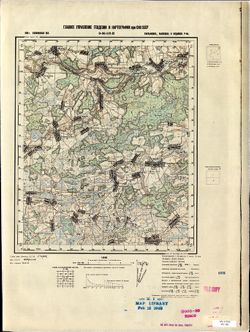
- Description:
- 1938
- Subject:
- Topical Subject: Maps, Topical Subject: Soviet Union, and Geographic Subject: Polomenitsy
- Publisher:
- Главное управление геодезии и картографии при СНК СССР
- Language:
- Russian
- Date Created:
- 1941
- Identifier:
- VAC9619-002904
- Genre:
- Military Maps and Topographic Maps
- Geographic Location:
- Coordinates: 56.667, 35, 56.833, 35.25
- Related URL:
- Catalog URL: http://iucat.iu.edu/catalog/5020131 and Download GeoTIFF: https://drive.google.com/file/d/1_WPD2YySqDnn5ZOBE2eLEB6FMHHGimLb/view?usp=sharing
- Abstract:
- Modern area represented: Поломеницы (Polomenitsy), Tverskaya oblast, Russia
- Call Number:
- GM G7000 s50 .S68 sheet O-36-119-C
- City:
- Поломеницы (Polomenitsy)
- Copyright Holder:
- No Copyright - United States
- Country:
- СССР (USSR)
- State/Province:
- Емельяновский район (Yemelyanovsky district), Высоковский район (Vysokovsky district), Медновский район (Mednovsky district), and Калининская область (Kalini...
- Physical Description:
- Scale: 1:50,000
- Persistent URL:
- http://purl.dlib.indiana.edu/iudl/images/VAC9619/VAC9619-002904
- Provenance:
- M. I. Map Library
-
- Description:
- 1939
- Subject:
- Topical Subject: Soviet Union, Geographic Subject: ostrov Karedzhi, and Topical Subject: Maps
- Publisher:
- Главное управление геодезии и картографии при СНК СССР
- Language:
- Russian
- Date Created:
- 1941
- Identifier:
- VAC9619-002952
- Genre:
- Military Maps and Topographic Maps
- Geographic Location:
- Coordinates: 60, 31.25, 60.167, 31.5
- Related URL:
- Catalog URL: http://iucat.iu.edu/catalog/5020131 and Download GeoTIFF: https://drive.google.com/file/d/1VwB1YlJ8nRbE3bZAbWP7nSesMwmFUrRU/view?usp=sharing
- Abstract:
- Modern area represented: остров Кареджи (ostrov Karedzhi)
- Call Number:
- GM G7000 s50 .S68 sheet P-36-135-D
- Caption:
- Для служебного пользования
- City:
- остров Кареджский (ostrov Karedzhskiy)
- Copyright Holder:
- No Copyright - United States
- Country:
- СССР (USSR)
- State/Province:
- Ленинградская область (Leningrad oblast), РСФСР (RSFSR), and Мгинский район (Mginsky district)
- Physical Description:
- Scale: 1:50,000
- Persistent URL:
- http://purl.dlib.indiana.edu/iudl/images/VAC9619/VAC9619-002952
- Provenance:
- DMA Topographic Center, Army Map Service Library, OMAHA, Library of Congress Geography & Map Division
-
- Description:
- 1939
- Subject:
- Geographic Subject: Kivgoda, Topical Subject: Soviet Union, and Topical Subject: Maps
- Publisher:
- Главное управление геодезии и картографии при СНК СССР
- Language:
- Russian
- Date Created:
- 1941
- Identifier:
- VAC9619-002953
- Genre:
- Military Maps and Topographic Maps
- Geographic Location:
- Coordinates: 60.167, 31.5, 60.333, 31.75
- Related URL:
- Catalog URL: http://iucat.iu.edu/catalog/5020131 and Download GeoTIFF: https://drive.google.com/file/d/1-NTMMBhpjvV0-U9w20hI8f4U0XiFpXDC/view?usp=sharing
- Abstract:
- Modern area represented: Kivgoda, Leningrad oblast, Russia
- Call Number:
- GM G7000 s50 .S68 sheet P-36-136-A
- Caption:
- Для служебного пользования
- City:
- Кивгода (Kivgoda)
- Copyright Holder:
- No Copyright - United States
- Country:
- СССР (USSR)
- State/Province:
- Ленинградская область (Leningrad oblast), Мгинский район (Mginsky district), РСФСР (RSFSR), and Волховский район (Volkhov district)
- Physical Description:
- Scale: 1:50,000
- Persistent URL:
- http://purl.dlib.indiana.edu/iudl/images/VAC9619/VAC9619-002953
- Provenance:
- DMA Topographic Center, Army Map Service Library, OMAHA, Library of Congress Geography & Map Division
-
- Description:
- 1939
- Subject:
- Topical Subject: Maps, Topical Subject: Soviet Union, and Geographic Subject: Kivgoda
- Publisher:
- Главное управление геодезии и картографии при СНК СССР
- Language:
- Russian
- Date Created:
- 1941
- Identifier:
- VAC9619-002954
- Genre:
- Topographic Maps and Military Maps
- Geographic Location:
- Coordinates: 60.167, 31.5, 60.333, 31.75
- Related URL:
- Catalog URL: http://iucat.iu.edu/catalog/5020131 and Download GeoTIFF: https://drive.google.com/file/d/1HsZDdQuQheN0ew-UwCH5ZNS1wdJthYzl/view?usp=sharing
- Abstract:
- Modern area represented: Kivgoda, Leningrad oblast, Russia
- Call Number:
- GM G7000 s50 .S68 sheet P-36-136-A
- Caption:
- Для служебного пользования
- City:
- Кивгода (Kivgoda)
- Copyright Holder:
- No Copyright - United States
- Country:
- СССР (USSR)
- State/Province:
- РСФСР (RSFSR), Ленинградская область (Leningrad oblast), Мгинский район (Mginsky district), and Волховский район (Volkhov district)
- Physical Description:
- Scale: 1:50,000
- Persistent URL:
- http://purl.dlib.indiana.edu/iudl/images/VAC9619/VAC9619-002954
- Provenance:
- Army Map Service Library, OMAHA, Library of Congress Geography & Map Division
-
- Description:
- 1939
- Subject:
- Topical Subject: Soviet Union, Topical Subject: Maps, and Geographic Subject: Dubno
- Publisher:
- Главное управление геодезии и картографии при СНК СССР
- Language:
- Russian
- Date Created:
- 1941
- Identifier:
- VAC9619-002955
- Genre:
- Topographic Maps and Military Maps
- Geographic Location:
- Coordinates: 60.16667, 31.75, 60.3333, 32.0
- Related URL:
- Download GeoTIFF: https://drive.google.com/file/d/1uIZ1zrQmo44Nz8EzHTws5XvPlG2YxEEn/view?usp=sharing and Catalog URL: http://iucat.iu.edu/catalog/5020131
- Abstract:
- Modern area represented: Dubno, Russia
- Call Number:
- GM G7000 s50 .S68 sheet P-36-136-B
- Caption:
- Для служебного пользования
- City:
- Дубно (Dubno)
- Copyright Holder:
- No Copyright - United States
- Country:
- СССР (USSR)
- State/Province:
- Волховский район (Volkhov district), Ленинградская область (Leningrad oblast), Мгинский район (Mginsky district), and РСФСР (RSFSR)
- Physical Description:
- Scale: 1:50,000
- Persistent URL:
- http://purl.dlib.indiana.edu/iudl/images/VAC9619/VAC9619-002955
- Provenance:
- DMA Topographic Center, Army Map Service Library, OMAHA, Library of Congress Geography & Map Division
-
- Description:
- 1939
- Subject:
- Topical Subject: Soviet Union, Geographic Subject: Kobona, and Topical Subject: Maps
- Publisher:
- Главное управление геодезии и картографии при СНК СССР
- Language:
- Russian
- Date Created:
- 1941
- Identifier:
- VAC9619-002956
- Genre:
- Military Maps and Topographic Maps
- Geographic Location:
- Coordinates: 60, 31.5, 60.167, 31.75
- Related URL:
- Catalog URL: http://iucat.iu.edu/catalog/5020131 and Download GeoTIFF: https://drive.google.com/file/d/1SOrZp1G2IEVT-xqbNGQCYjxtglsAbxBK/view?usp=sharing
- Abstract:
- Modern area represented: Kobona, Leningrad oblast, Russia
- Call Number:
- GM G7000 s50 .S68 sheet P-36-136-C
- Caption:
- Секретно
- City:
- Кобона (Kobona)
- Copyright Holder:
- No Copyright - United States
- Country:
- СССР (USSR)
- State/Province:
- Ленинградская область (Leningrad oblast), РСФСР (RSFSR), and Мгинский район (Mginsky district)
- Physical Description:
- Scale: 1:50,000
- Persistent URL:
- http://purl.dlib.indiana.edu/iudl/images/VAC9619/VAC9619-002956
- Provenance:
- DMA Topographic Center, Army Map Service Library, Library of Congress Geography & Map Division
-
- Description:
- 1939
- Subject:
- Topical Subject: Maps, Geographic Subject: Dubno, and Topical Subject: Soviet Union
- Publisher:
- Главное управление геодезии и картографии при СНК СССР
- Language:
- Russian
- Date Created:
- 1941
- Identifier:
- VAC9619-002958
- Genre:
- Topographic Maps and Military Maps
- Geographic Location:
- Coordinates: 60.167, 31.75, 60.333, 32
- Related URL:
- Catalog URL: http://iucat.iu.edu/catalog/5020131 and Download GeoTIFF: https://drive.google.com/file/d/1_oN_nUdwzyKSSGP5NvG4HkudzQzWBekR/view?usp=sharing
- Abstract:
- Modern area represented: Dubno, Russia
- Call Number:
- GM G7000 s50 .S68 sheet P-36-136-Б
- Caption:
- Для служебного пользования
- City:
- Дубно (Dubno)
- Copyright Holder:
- No Copyright - United States
- Country:
- СССР (USSR)
- State/Province:
- Мгинский район (Mginsky district), Ленинградская область (Leningrad oblast), Волховский район (Volkhov district), and РСФСР (RSFSR)
- Physical Description:
- Scale: 1:50,000
- Persistent URL:
- http://purl.dlib.indiana.edu/iudl/images/VAC9619/VAC9619-002958
- Provenance:
- Army Map Service Library, OMAHA, Library of Congress Geography & Map Division
-
- Description:
- 1939
- Subject:
- Topical Subject: Soviet Union, Topical Subject: Maps, and Geographic Subject: Ostrov
- Publisher:
- Главное управление геодезии и картографии при СНК СССР
- Language:
- Russian
- Date Created:
- 1941
- Identifier:
- VAC9619-002957
- Genre:
- Military Maps and Topographic Maps
- Geographic Location:
- Coordinates: 60, 31.75, 60.167, 32
- Related URL:
- Catalog URL: http://iucat.iu.edu/catalog/5020131 and Download GeoTIFF: https://drive.google.com/file/d/17pBS93leK5HdBIyVCAHPECmK_QwD68KD/view?usp=sharing
- Abstract:
- Modern area represented: Ostrov, Russia
- Call Number:
- GM G7000 s50 .S68 sheet P-36-136-D
- Caption:
- Для служебного пользования
- City:
- Остров (Ostrov)
- Copyright Holder:
- No Copyright - United States
- Country:
- СССР (USSR)
- State/Province:
- Волховский район (Volkhov district), Мгинский район (Mginsky district), РСФСР (RSFSR), and Ленинградская область (Leningrad oblast)
- Physical Description:
- Scale: 1:50,000
- Persistent URL:
- http://purl.dlib.indiana.edu/iudl/images/VAC9619/VAC9619-002957
- Provenance:
- DMA Topographic Center, Army Map Service Library, OMAHA, Library of Congress Geography & Map Division
-
- Description:
- 1939
- Subject:
- Geographic Subject: Ostrov, Topical Subject: Maps, and Topical Subject: Soviet Union
- Publisher:
- Главное управление геодезии и картографии при СНК СССР
- Language:
- Russian
- Date Created:
- 1941
- Identifier:
- VAC9619-002959
- Genre:
- Topographic Maps and Military Maps
- Geographic Location:
- Coordinates: 60, 31.75, 60.167, 32
- Related URL:
- Download GeoTIFF: https://drive.google.com/file/d/1wwXjUQIb6R-FLzm89tMBlchTUaRkJ9jq/view?usp=sharing and Catalog URL: http://iucat.iu.edu/catalog/5020131
- Abstract:
- Modern area represented: Ostrov, Russia
- Call Number:
- G7000 s100 .S7 sheet P-36-136-D
- Caption:
- Для служебного пользования
- City:
- Остров (Ostrov)
- Copyright Holder:
- No Copyright - United States
- Country:
- СССР (USSR)
- State/Province:
- Волховский район (Volkhov district), РСФСР (RSFSR), Ленинградская область (Leningrad oblast), and Мгинский район (Mginsky district)
- Physical Description:
- Scale: 1:50,000
- Persistent URL:
- http://purl.dlib.indiana.edu/iudl/images/VAC9619/VAC9619-002959
- Provenance:
- Army Map Service Library, OMAHA, Library of Congress Geography & Map Division
-
- Description:
- 1939
- Subject:
- Topical Subject: Soviet Union, Topical Subject: Maps, and Geographic Subject: Zhikharevo
- Publisher:
- Главное управление геодезии и картографии при СНК СССР
- Language:
- Russian
- Identifier:
- VAC9619-003001
- Genre:
- Topographic Maps and Military Maps
- Geographic Location:
- Coordinates: 59.667, 31.5, 59.833, 31.75
- Related URL:
- Download GeoTIFF: https://drive.google.com/file/d/1eovBFV89UwF1-rZdZAl3hgG7UVjyN6GX/view?usp=sharing and Catalog URL: http://iucat.iu.edu/catalog/5020131
- Abstract:
- Modern area represented: Zhikharevo, Leningrad oblast, Russia
- Call Number:
- GM G7000 s50 .S68 sheet O-36-4-C
- Caption:
- Captured map
- City:
- Жихарево (Zhikharevo)
- Copyright Holder:
- No Copyright - United States
- Country:
- СССР (USSR)
- State/Province:
- Ленинградская область (Leningrad oblast), РСФСР (RSFSR), and Мгинский район (Mginsky district)
- Physical Description:
- Scale: 1:50,000
- Persistent URL:
- http://purl.dlib.indiana.edu/iudl/images/VAC9619/VAC9619-003001
- Provenance:
- DMA Topographic Center, Army Map Service Library, OMAHA, Library of Congress Geography & Map Division
-
- Description:
- 1939
- Subject:
- Topical Subject: Maps, Geographic Subject: Memino, and Topical Subject: Soviet Union
- Publisher:
- Главное управление геодезии и картографии при СНК СССР
- Language:
- Russian
- Identifier:
- VAC9619-003002
- Genre:
- Military Maps and Topographic Maps
- Geographic Location:
- Coordinates: 59.66667, 31.75, 59.83333, 32.0
- Related URL:
- Catalog URL: http://iucat.iu.edu/catalog/5020131 and Download GeoTIFF: https://drive.google.com/file/d/1P_cS5JnVEr21jmbR2LuZTYnSdlAsz9Hn/view?usp=sharing
- Abstract:
- Modern area represented: Memino, Leningrad oblast, Russia
- Call Number:
- GM G7000 s50 .S68 sheet O-36-4-D
- Caption:
- Для служебного пользования,Captured map
- City:
- Мемино (Memino)
- Copyright Holder:
- No Copyright - United States
- Country:
- СССР (USSR)
- State/Province:
- Ленинградская область (Leningrad oblast), Мгинский район (Mginsky district), Киришский район (Kirishsky district), and РСФСР (RSFSR)
- Physical Description:
- Scale: 1:50,000
- Persistent URL:
- http://purl.dlib.indiana.edu/iudl/images/VAC9619/VAC9619-003002
- Provenance:
- DMA Topographic Center, Army Map Service Library, OMAHA, Library of Congress Geography & Map Division
-
- Description:
- 1939
- Subject:
- Geographic Subject: Khotovo, Topical Subject: Soviet Union, and Topical Subject: Maps
- Publisher:
- Главное управление геодезии и картографии при СНК СССР
- Language:
- Russian
- Identifier:
- VAC9619-003003
- Genre:
- Topographic Maps and Military Maps
- Geographic Location:
- Coordinates: 59.667, 32, 59.833, 32.25
- Related URL:
- Catalog URL: http://iucat.iu.edu/catalog/5020131 and Download GeoTIFF: https://drive.google.com/file/d/1aAxrCsTissYEBPfIjFR-WJZPjdYV7qTb/view?usp=sharing
- Abstract:
- Modern area represented: Khotovo, Leningrad oblast, Russia
- Call Number:
- GM G7000 s50 .S68 sheet O-36-5-C
- Caption:
- Секретно,Captured map
- City:
- Хотово (Khotovo)
- Copyright Holder:
- No Copyright - United States
- Country:
- СССР (USSR)
- State/Province:
- Ленинградская область (Leningrad oblast), Киришский район (Kirishsky district), Волховский район (Volkhov district), РСФСР (RSFSR), and Мгинский район (Mgins...
- Physical Description:
- Scale: 1:50,000
- Persistent URL:
- http://purl.dlib.indiana.edu/iudl/images/VAC9619/VAC9619-003003
- Provenance:
- DMA Topographic Center, Army Map Service Library, OMAHA, Library of Congress Geography & Map Division
-
- Description:
- 1939
- Subject:
- Geographic Subject: Vyndin Ostrov, Topical Subject: Maps, and Topical Subject: Soviet Union
- Publisher:
- Главное управление геодезии и картографии при СНК СССР
- Language:
- Russian
- Date Created:
- 1941
- Identifier:
- VAC9619-003004
- Genre:
- Military Maps and Topographic Maps
- Geographic Location:
- Coordinates: 59.667, 32.25, 59.833, 32.5
- Related URL:
- Download GeoTIFF: https://drive.google.com/file/d/1hytAurvFfDscj_JnoC02Ncqrt2UfUir5/view?usp=sharing and Catalog URL: http://iucat.iu.edu/catalog/5020131
- Abstract:
- Modern area represented: Vyndin Ostrov, Leningrad oblast, Russia
- Call Number:
- GM G7000 s50 .S68 sheet O-36-5-D
- Caption:
- Секретно,Captured map
- City:
- Вындин Остров (Vyndin Ostrov)
- Copyright Holder:
- No Copyright - United States
- Country:
- СССР (USSR)
- State/Province:
- Волховский район (Volkhov district), РСФСР (RSFSR), and Ленинградская область (Leningrad oblast)
- Physical Description:
- Scale: 1:50,000
- Persistent URL:
- http://purl.dlib.indiana.edu/iudl/images/VAC9619/VAC9619-003004
- Provenance:
- DMA Topographic Center, Army Map Service Library, OMAHA, Library of Congress Geography & Map Division
-
- Description:
- 1938
- Subject:
- Topical Subject: Soviet Union, Geographic Subject: Chekhov, and Topical Subject: Maps
- Publisher:
- Главное управление геодезии и картографии при СНК СССР
- Language:
- Russian
- Date Created:
- 1941
- Identifier:
- VAC9619-003087
- Genre:
- Topographic Maps and Military Maps
- Geographic Location:
- Coordinates: 55, 37, 55.333, 37.5
- Related URL:
- Catalog URL: https://iucat.iu.edu/catalog/5020129 and Download GeoTIFF: https://drive.google.com/file/d/1XcoDpgmjiqjjBUM3erN57ycjXsexWRQm/view?usp=sharing
- Abstract:
- Modern area represented: Чехов (Chekhov), Moscow oblast, Russia
- Call Number:
- G7000 s100 .S7 sheet N-37-27
- Caption:
- Для служебного пользования
- City:
- Лопасня (Lopasnya)
- Copyright Holder:
- No Copyright - United States
- Country:
- СССР (USSR)
- State/Province:
- Московская область (Moscow oblast) and РСФСР (RSFSR)
- Physical Description:
- Scale: 1:100,000
- Persistent URL:
- http://purl.dlib.indiana.edu/iudl/images/VAC9619/VAC9619-003087
- Provenance:
- DMA Topographic Center, Army Map Service Library, OMAHA, Library of Congress Geography & Map Division
-
- Subject:
- Topical Subject: Soviet Union, Topical Subject: Maps, and Geographic Subject: Malino
- Publisher:
- Главное управление геодезии и картографии при СНК СССР
- Language:
- Russian
- Date Created:
- 1941
- Identifier:
- VAC9619-003092
- Genre:
- Topographic Maps and Military Maps
- Geographic Location:
- Coordinates: 55, 38, 55.333, 38.5
- Related URL:
- Download GeoTIFF: https://drive.google.com/file/d/1VJnbqEqMvzvH9EHGVUXybabjU9pJVeI4/view?usp=sharing and Catalog URL: https://iucat.iu.edu/catalog/5020129
- Abstract:
- Modern area represented: Malino, Russia
- Call Number:
- G7000 s100 .S7 sheet N-37-29
- City:
- Малино (Malino)
- Copyright Holder:
- No Copyright - United States
- Country:
- СССР (USSR)
- State/Province:
- РСФСР (RSFSR) and Московская область (Moscow oblast)
- Physical Description:
- Scale: 1:100,000
- Persistent URL:
- http://purl.dlib.indiana.edu/iudl/images/VAC9619/VAC9619-003092
- Provenance:
- DMA Topographic Center, Army Map Service Library, OMAHA, Library of Congress Geography & Map Division
-
- Description:
- 1939
- Subject:
- Topical Subject: Soviet Union, Geographic Subject: Kolomna, and Topical Subject: Maps
- Publisher:
- Главное управление геодезии и картографии при СНК СССР
- Language:
- Russian
- Date Created:
- 1941
- Identifier:
- VAC9619-003094
- Genre:
- Military Maps and Topographic Maps
- Geographic Location:
- Coordinates: 55, 38.5, 55.333, 39
- Related URL:
- Catalog URL: https://iucat.iu.edu/catalog/5020129 and Download GeoTIFF: https://drive.google.com/file/d/1R-CkbwaDJZ-gIFEX3L5pDRh29r_POtHa/view?usp=sharing
- Abstract:
- Modern area represented: Kolomna, Moscow oblast, Russia
- Call Number:
- G7000 s100 .S7 sheet N-37-30
- Caption:
- Для служебного пользования
- City:
- Коломна (Kolomna)
- Copyright Holder:
- No Copyright - United States
- Country:
- СССР (USSR)
- State/Province:
- РСФСР (RSFSR) and Московская область (Moscow oblast)
- Physical Description:
- Scale: 1:100,000
- Persistent URL:
- http://purl.dlib.indiana.edu/iudl/images/VAC9619/VAC9619-003094
- Provenance:
- DMA Topographic Center, Army Map Service Library, OMAHA, Library of Congress Geography & Map Division, Geographic Names Branch
-
- Subject:
- Geographic Subject: Dedinovo, Topical Subject: Maps, and Topical Subject: Soviet Union
- Publisher:
- Главное управление геодезии и картографии при СНК СССР
- Language:
- Russian
- Date Created:
- 1941
- Identifier:
- VAC9619-003095
- Genre:
- Topographic Maps and Military Maps
- Geographic Location:
- Coordinates: 55, 39, 55.333, 39.5
- Related URL:
- Download GeoTIFF: https://drive.google.com/file/d/1eN0cV502r01iOQpn7HYEkxZMk3HcFoP3/view?usp=sharing and Catalog URL: https://iucat.iu.edu/catalog/5020129
- Abstract:
- Modern area represented: Dedinovo, Moscow oblast, Russia
- Call Number:
- G7000 s100 .S7 sheet N-37-31
- City:
- Дединово (Dedinovo)
- Copyright Holder:
- No Copyright - United States
- Country:
- СССР (USSR)
- State/Province:
- РСФСР (RSFSR) and Московская область (Moscow oblast)
- Physical Description:
- Scale: 1:100,000
- Persistent URL:
- http://purl.dlib.indiana.edu/iudl/images/VAC9619/VAC9619-003095
- Provenance:
- DMA Topographic Center, Army Map Service Library, OMAHA, Library of Congress Geography & Map Division, Auswärtiges Amt. Geographischer Dienst
-

- Subject:
- Geographic Subject: Serpukhov, Topical Subject: Soviet Union, and Topical Subject: Maps
- Publisher:
- Главное управление геодезии и картографии при СНК СССР
- Language:
- Russian
- Date Created:
- 1941
- Identifier:
- VAC9619-003100
- Genre:
- Military Maps and Topographic Maps
- Geographic Location:
- Coordinates: 54.667, 37, 55, 37.5
- Related URL:
- Catalog URL: https://iucat.iu.edu/catalog/5020129 and Download GeoTIFF: https://drive.google.com/file/d/1YXi_kgRInGAQDNE3p1BfFL8ZnKZsEQ17/view?usp=sharing
- Abstract:
- Modern area represented: Serpukhov, Russia
- Call Number:
- G7000 s100 .S7 sheet N-37-39
- Caption:
- Для служебного пользования
- City:
- Серпухов (Serpukhov)
- Copyright Holder:
- No Copyright - United States
- Country:
- СССР (USSR)
- State/Province:
- Тульская область (Tula oblast), РСФСР (RSFSR), and Московская область (Moscow oblast)
- Physical Description:
- Scale: 1:100,000
- Persistent URL:
- http://purl.dlib.indiana.edu/iudl/images/VAC9619/VAC9619-003100
- Provenance:
- DMA Topographic Center, Army Map Service Library, Library of Congress Geography & Map Division
-
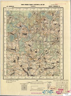
- Description:
- 1938
- Subject:
- Geographic Subject: Babino, Topical Subject: Maps, and Topical Subject: Soviet Union
- Publisher:
- Главное управление геодезии и картографии при СНК СССР
- Language:
- Russian
- Date Created:
- 1941
- Identifier:
- VAC9619-002900
- Genre:
- Military Maps and Topographic Maps
- Geographic Location:
- Coordinates: 56.667, 34.25, 56.833, 34.5
- Related URL:
- Catalog URL: http://iucat.iu.edu/catalog/5020131 and Download GeoTIFF: https://drive.google.com/file/d/1kvkj8mWZ5zPHyjzqi4MrXbCdj1_1dU3l/view?usp=sharing
- Abstract:
- Modern area represented: Бабино (Babino), Tverskaya oblast, Russia
- Call Number:
- GM G7000 s50 .S68 sheet O-36-117-D
- Caption:
- Для служебного пользования
- City:
- Бабино (Babino)
- Copyright Holder:
- No Copyright - United States
- Country:
- СССР (USSR)
- State/Province:
- Калининская область (Kalinin oblast), Каменский район (Kamensky district), and Луковниковский район (Lukovnikovsky district)
- Physical Description:
- Scale: 1:50,000
- Persistent URL:
- http://purl.dlib.indiana.edu/iudl/images/VAC9619/VAC9619-002900
- Provenance:
- M. I. Map Library, Library of Congress Geography & Map Division
-
- Description:
- 1938
- Subject:
- Geographic Subject: Pryamukhino, Topical Subject: Maps, and Topical Subject: Soviet Union
- Publisher:
- Главное управление геодезии и картографии при СНК СССР
- Language:
- Russian
- Date Created:
- 1941
- Identifier:
- VAC9619-002899
- Genre:
- Military Maps and Topographic Maps
- Geographic Location:
- Coordinates: 56.833, 34.25, 57, 34.5
- Related URL:
- Catalog URL: http://iucat.iu.edu/catalog/5020131 and Download GeoTIFF: https://drive.google.com/file/d/1wgoZ8GCh8qkMdSZsDU8QuxF15aFr0Ndj/view?usp=sharing
- Abstract:
- Modern area represented: Прямухино (Pryamukhino), Tverskaya oblast, Russia
- Call Number:
- GM G7000 s50 .S68 sheet O-36-117-В
- Caption:
- Для служебного пользования
- City:
- Прямухино (Pryamukhino)
- Copyright Holder:
- No Copyright - United States
- Country:
- СССР (USSR)
- State/Province:
- Калининская область (Kalinin oblast), Каменский район (Kamensky district), and Луковниковский район (Lukovnikovsky district)
- Physical Description:
- Scale: 1:50,000
- Persistent URL:
- http://purl.dlib.indiana.edu/iudl/images/VAC9619/VAC9619-002899
- Provenance:
- DMA Topographic Center, Army Map Service Library, OMAHA, Library of Congress Geography & Map Division
-
- Description:
- 1939
- Subject:
- Geographic Subject: Kiselevo, Topical Subject: Soviet Union, and Topical Subject: Maps
- Publisher:
- Главное управление геодезии и картографии при СНК СССР
- Language:
- Russian
- Date Created:
- 1941
- Identifier:
- VAC9619-002898
- Genre:
- Topographic Maps and Military Maps
- Geographic Location:
- Coordinates: 56.667, 33.75, 56.833, 34
- Related URL:
- Download GeoTIFF: https://drive.google.com/file/d/1iCxa_z7EiPxrrLftE7DkTTOitHYYW6yh/view?usp=sharing and Catalog URL: http://iucat.iu.edu/catalog/5020131
- Abstract:
- Modern area represented: Киселево (Kiselevo), Tverskaya oblast, Russia
- Call Number:
- GM G7000 s50 .S68 sheet O-36-116-D
- Caption:
- Для служебного пользования
- City:
- Киселево (Kiselevo)
- Copyright Holder:
- No Copyright - United States
- Country:
- СССР (USSR)
- State/Province:
- Луковниковский район (Lukovnikovsky district), Кировский район (Kirov district), and Калининская область (Kalinin oblast)
- Physical Description:
- Scale: 1:50,000
- Persistent URL:
- http://purl.dlib.indiana.edu/iudl/images/VAC9619/VAC9619-002898
- Provenance:
- DMA Topographic Center, Army Map Service Library, OMAHA, Library of Congress Geography & Map Division
-

- Description:
- 1939
- Subject:
- Topical Subject: Maps, Geographic Subject: Vyshegorod, and Topical Subject: Soviet Union
- Publisher:
- Главное управление геодезии и картографии при СНК СССР
- Language:
- Russian
- Date Created:
- 1941
- Identifier:
- VAC9619-002897
- Genre:
- Military Maps and Topographic Maps
- Geographic Location:
- Coordinates: 56.6667, 33.5, 56.8333, 33.75
- Related URL:
- Catalog URL: http://iucat.iu.edu/catalog/5020131 and Download GeoTIFF: https://drive.google.com/file/d/1Yz4ZBUF-IvzvEjei_et63zhO83cB3S2-/view?usp=sharing
- Abstract:
- Modern area represented: Вышегород (Vyshegorod), Tverskaya oblast, Russia
- Call Number:
- GM G7000 s50 .S68 sheet О-36-116-C
- Caption:
- Для служебного пользования
- City:
- Вышегород (Vyshegorod)
- Copyright Holder:
- No Copyright - United States
- Country:
- СССР (USSR)
- State/Province:
- Калининская область (Kalinin oblast) and Кировский район (Kirov district)
- Physical Description:
- Scale: 1:50,000
- Persistent URL:
- http://purl.dlib.indiana.edu/iudl/images/VAC9619/VAC9619-002897
- Provenance:
- DMA Topographic Center, Army Map Service Library, OMAHA, Library of Congress Geography & Map Division
-
- Description:
- 1939
- Subject:
- Geographic Subject: Brylevo, Topical Subject: Maps, and Topical Subject: Soviet Union
- Publisher:
- Главное управление геодезии и картографии при СНК СССР
- Language:
- Russian
- Date Created:
- 1941
- Identifier:
- VAC9619-002896
- Genre:
- Military Maps and Topographic Maps
- Geographic Location:
- Coordinates: 56.833, 33.75, 57, 34
- Related URL:
- Download GeoTIFF: https://drive.google.com/file/d/1Sei87ryO3y3FbwBurMqcWFN1Hz26k9j7/view?usp=sharing and Catalog URL: http://iucat.iu.edu/catalog/5020131
- Abstract:
- Modern area represented: Брылево (Brylevo), Tverskaya oblast, Russia
- Call Number:
- GM G7000 s50 .S68 sheet O-36-116-B
- Caption:
- Для служебного пользования
- City:
- Брылево (Brylevo)
- Copyright Holder:
- No Copyright - United States
- Country:
- СССР (USSR)
- State/Province:
- Кировский район (Kirov district), Каменский район (Kamensky district), Калининская область (Kalinin oblast), and Луковниковский район (Lukovnikovsky district)
- Physical Description:
- Scale: 1:50,000
- Persistent URL:
- http://purl.dlib.indiana.edu/iudl/images/VAC9619/VAC9619-002896
- Provenance:
- DMA Topographic Center, Army Map Service Library, OMAHA, Library of Congress Geography & Map Division
-

- Description:
- 1939
- Subject:
- Geographic Subject: Felistovo, Topical Subject: Maps, and Topical Subject: Soviet Union
- Publisher:
- Главное управление геодезии и картографии при СНК СССР
- Language:
- Russian
- Date Created:
- 1941
- Identifier:
- VAC9619-002894
- Genre:
- Military Maps and Topographic Maps
- Geographic Location:
- Coordinates: 56.667, 33.25, 56.833, 33.5
- Related URL:
- Download GeoTIFF: https://drive.google.com/file/d/1e3n-bYV2JUuoXJS278EseNAJhPVS7Wyc/view?usp=sharing and Catalog URL: http://iucat.iu.edu/catalog/5020131
- Abstract:
- Modern area represented: Фелистово (Felistovo), Tverskaya oblast, Russia
- Call Number:
- GM G7000 s50 .S68 sheet O-36-115-D
- Caption:
- Для служебного пользования
- City:
- Фелистово (Felistovo)
- Copyright Holder:
- No Copyright - United States
- Country:
- СССР (USSR)
- State/Province:
- Кировский район (Kirov district) and Калининская область (Kalinin oblast)
- Physical Description:
- Scale: 1:50,000
- Persistent URL:
- http://purl.dlib.indiana.edu/iudl/images/VAC9619/VAC9619-002894
- Provenance:
- DMA Topographic Center, Army Map Service Library, OMAHA, Library of Congress Geography & Map Division
-
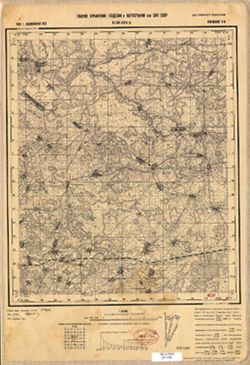
- Description:
- 1939
- Subject:
- Topical Subject: Maps, Topical Subject: Soviet Union, and Geographic Subject: Berezug
- Publisher:
- Главное управление геодезии и картографии при СНК СССР
- Language:
- Russian
- Date Created:
- 1941
- Identifier:
- VAC9619-002895
- Genre:
- Topographic Maps and Military Maps
- Geographic Location:
- Coordinates: 56.833, 33.5, 57, 33.75
- Related URL:
- Catalog URL: http://iucat.iu.edu/catalog/5020131 and Download GeoTIFF: https://drive.google.com/file/d/117hKFp8W7arwEX0DOR-VCKzzwvS2-6nw/view?usp=sharing
- Abstract:
- Modern area represented: Березуг (Berezug), Tverskaya oblast, Russia
- Call Number:
- GM G7000 s50 .S68 sheet O-36-116-A
- Caption:
- Для служебного пользования
- City:
- Березуг (Berezug)
- Copyright Holder:
- No Copyright - United States
- Country:
- СССР (USSR)
- State/Province:
- Кировский район (Kirov district) and Калининская область (Kalinin oblast)
- Physical Description:
- Scale: 1:50,000
- Persistent URL:
- http://purl.dlib.indiana.edu/iudl/images/VAC9619/VAC9619-002895
- Provenance:
- DMA Topographic Center, Army Map Service Library, OMAHA, Library of Congress Geography & Map Division
-
- Description:
- 1939
- Subject:
- Geographic Subject: Dubrovki, Topical Subject: Maps, and Topical Subject: Soviet Union
- Publisher:
- Главное управление геодезии и картографии при СНК СССР
- Language:
- Russian
- Date Created:
- 1941
- Identifier:
- VAC9619-002893
- Genre:
- Military Maps and Topographic Maps
- Geographic Location:
- Coordinates: 56.667, 33, 56.833, 33.25
- Related URL:
- Catalog URL: http://iucat.iu.edu/catalog/5020131 and Download GeoTIFF: https://drive.google.com/file/d/11w3Bp0joUPKgvkQ2d6XuwvsEuh3saXCy/view?usp=sharing
- Abstract:
- Modern area represented: Дубровки (Dubrovki), Tverskaya oblast, Russia
- Call Number:
- GM G7000 s50 .S68 sheet O-36-115-C
- Caption:
- Для служебного пользования
- City:
- Дубровки (Dubrovki)
- Copyright Holder:
- No Copyright - United States
- Country:
- СССР (USSR)
- State/Province:
- Пеновский район (Penovsky district), Калининская область (Kalinin oblast), and Кировский район (Kirov district)
- Physical Description:
- Scale: 1:50,000
- Persistent URL:
- http://purl.dlib.indiana.edu/iudl/images/VAC9619/VAC9619-002893
- Provenance:
- DMA Topographic Center, Army Map Service Library, OMAHA, Library of Congress Geography & Map Division
-
- Description:
- 1939
- Subject:
- Topical Subject: Soviet Union, Geographic Subject: Selekhovo, and Topical Subject: Maps
- Publisher:
- Главное управление геодезии и картографии при СНК СССР
- Language:
- Russian
- Date Created:
- 1941
- Identifier:
- VAC9619-002892
- Genre:
- Military Maps and Topographic Maps
- Geographic Location:
- Coordinates: 56.667, 32.75, 56.833, 33
- Related URL:
- Download GeoTIFF: https://drive.google.com/file/d/1zVNUyKVX6m3kJgBmAvRA24cSHh2lwrCl/view?usp=sharing and Catalog URL: http://iucat.iu.edu/catalog/5020131
- Abstract:
- Modern area represented: Селехово (Selekhovo), Tverskaya oblast, Russia
- Call Number:
- GM G7000 s50 .S68 sheet O-36-114-D
- Caption:
- Для служебного пользования
- City:
- Селехово (Selekhovo)
- Copyright Holder:
- No Copyright - United States
- Country:
- СССР (USSR)
- State/Province:
- Пеновский район (Penovsky district), Калининская область (Kalinin oblast), and Леновский район (Lenovsky district)
- Physical Description:
- Scale: 1:50,000
- Persistent URL:
- http://purl.dlib.indiana.edu/iudl/images/VAC9619/VAC9619-002892
- Provenance:
- DMA Topographic Center, Army Map Service Library, OMAHA, Library of Congress Geography & Map Division
-
- Description:
- 1939
- Subject:
- Topical Subject: Soviet Union, Topical Subject: Maps, and Geographic Subject: Shuvayevo
- Publisher:
- Главное управление геодезии и картографии при СНК СССР
- Language:
- Russian
- Date Created:
- 1941
- Identifier:
- VAC9619-002891
- Genre:
- Topographic Maps and Military Maps
- Geographic Location:
- Coordinates: 56.833, 33, 57, 33.25
- Related URL:
- Download GeoTIFF: https://drive.google.com/file/d/13FWxkADRE7fKlwOO1oh0LeFe8xTQPSzX/view?usp=sharing and Catalog URL: http://iucat.iu.edu/catalog/5020131
- Abstract:
- Modern area represented: Шуваево (Shuvayevo), Tverskaya oblast, Russia
- Call Number:
- GM G7000 s50 .S68 sheet O-36-115-A
- Caption:
- Для служебного пользования
- City:
- Шуваево (Shuvayevo)
- Copyright Holder:
- No Copyright - United States
- Country:
- СССР (USSR)
- State/Province:
- Калининская область (Kalinin oblast) and РСФСР (RSFSR)
- Physical Description:
- Scale: 1:50,000
- Persistent URL:
- http://purl.dlib.indiana.edu/iudl/images/VAC9619/VAC9619-002891
- Provenance:
- DMA Topographic Center, Army Map Service Library, OMAHA, Library of Congress Geography & Map Division
-
- Description:
- 1939
- Subject:
- Topical Subject: Soviet Union, Topical Subject: Maps, and Geographic Subject: Okhvat
- Publisher:
- Главное управление геодезии и картографии при СНК СССР
- Language:
- Russian
- Identifier:
- VAC9619-002890
- Genre:
- Military Maps and Topographic Maps
- Geographic Location:
- Coordinates: 56.667, 32.25, 56.833, 32.5
- Related URL:
- Catalog URL: http://iucat.iu.edu/catalog/5020131 and Download GeoTIFF: https://drive.google.com/file/d/12gpJLt5cYQ-4EyKfpoFZBoYFcmuVjtDC/view?usp=sharing
- Abstract:
- Modern area represented: Охват (Okhvat), Tverskaya oblast, Russia
- Call Number:
- GM G7000 s50 .S68 sheet O-36-113-D
- Caption:
- Для служебного пользования and Captured map
- City:
- Охват (Okhvat)
- Copyright Holder:
- No Copyright - United States
- Country:
- СССР (USSR)
- State/Province:
- Пеновский район (Penovsky district), Калининская область (Kalinin oblast), and Ленинский район (Leninsky district)
- Physical Description:
- Scale: 1:50,000
- Persistent URL:
- http://purl.dlib.indiana.edu/iudl/images/VAC9619/VAC9619-002890
- Provenance:
- Army Map Service Library, OMAHA, Library of Congress Geography & Map Division
-
- Description:
- 1939
- Subject:
- Geographic Subject: Dudino, Topical Subject: Maps, and Topical Subject: Soviet Union
- Publisher:
- Главное управление геодезии и картографии при СНК СССР
- Language:
- Russian
- Identifier:
- VAC9619-002889
- Genre:
- Military Maps and Topographic Maps
- Geographic Location:
- Coordinates: 56.667, 32, 56.833, 32.25
- Related URL:
- Download GeoTIFF: https://drive.google.com/file/d/1Py3jDGm2QyjkNIWE8MgDv-5TtIaWklTa/view?usp=sharing and Catalog URL: http://iucat.iu.edu/catalog/5020131
- Abstract:
- Modern area represented: Дудино (Dudino), Tverskaya oblast, Russia
- Call Number:
- GM G7000 s50 .S68 sheet O-36-113-C
- Caption:
- Captured map and Для служебного пользования
- City:
- Дудино (Dudino)
- Copyright Holder:
- No Copyright - United States
- Country:
- СССР (USSR)
- State/Province:
- Калининская область (Kalinin oblast), Ленинский район (Leninsky district), and Пеновский район (Penovsky district)
- Physical Description:
- Scale: 1:50,000
- Persistent URL:
- http://purl.dlib.indiana.edu/iudl/images/VAC9619/VAC9619-002889
- Provenance:
- Army Map Service Library, OMAHA, Library of Congress Geography & Map Division
-
- Description:
- 1939
- Subject:
- Topical Subject: Maps, Topical Subject: Soviet Union, and Geographic Subject: Zabor’ye
- Publisher:
- Главное управление геодезии и картографии при СНК СССР
- Language:
- Russian
- Date Created:
- 1941
- Identifier:
- VAC9619-002888
- Genre:
- Topographic Maps and Military Maps
- Geographic Location:
- Coordinates: 56.833, 32.25, 57, 32.5
- Related URL:
- Catalog URL: http://iucat.iu.edu/catalog/5020131 and Download GeoTIFF: https://drive.google.com/file/d/1Bb2CzrK0F9Jaw1SPk85X2tY3L5pI2C0f/view?usp=sharing
- Abstract:
- Modern area represented: Заборье (Zabor’ye), Tverskaya oblast, Russia
- Call Number:
- GM G7000 s50 .S68 sheet O-36-113-B
- Caption:
- Captured map and Для служебного польлзования
- City:
- Заборье (Zabor’ye)
- Copyright Holder:
- No Copyright - United States
- Country:
- СССР (USSR)
- State/Province:
- Калининская область (Kalinin oblast), Пеновский район (Penovsky district), and Ленинский район (Leninsky district)
- Physical Description:
- Scale: 1:50,000
- Persistent URL:
- http://purl.dlib.indiana.edu/iudl/images/VAC9619/VAC9619-002888
- Provenance:
- Army Map Service Library, OMAHA, Library of Congress Geography & Map Division
-
- Description:
- 1939
- Subject:
- Topical Subject: Maps, Geographic Subject: Moskva, and Topical Subject: Soviet Union
- Publisher:
- Главное управление геодезии и картографии при СНК СССР
- Language:
- Russian
- Date Created:
- 1941
- Identifier:
- VAC9619-002887
- Genre:
- Military Maps and Topographic Maps
- Geographic Location:
- Coordinates: 56.833, 32, 57, 32.25
- Related URL:
- Download GeoTIFF: https://drive.google.com/file/d/1HXLiYhmYiLMFmGgV_fpSiNKzREzlQm5_/view?usp=sharing and Catalog URL: http://iucat.iu.edu/catalog/5020131
- Abstract:
- Modern area represented: Москва (Moskva), Tverskaya oblast, Russia
- Call Number:
- GM G7000 s50 .S68 sheet O-36-113-A
- Caption:
- Для служебного польлзования and Captured map
- City:
- Москва (Moskva)
- Copyright Holder:
- No Copyright - United States
- Country:
- СССР (USSR)
- State/Province:
- Сережинский район (Serezhinsky district), Калининская область (Kalinin oblast), Ленинский район (Leninsky district), and Пеновский район (Penovsky district)
- Physical Description:
- Scale: 1:50,000
- Persistent URL:
- http://purl.dlib.indiana.edu/iudl/images/VAC9619/VAC9619-002887
- Provenance:
- Army Map Service Library, OMAHA, Library of Congress Geography & Map Division
-
- Subject:
- Topical Subject: Soviet Union, Geographic Subject: Toropatsa, and Topical Subject: Maps
- Publisher:
- Главное управление геодезии и картографии при СНК СССР
- Language:
- Russian
- Date Created:
- 1941
- Identifier:
- VAC9619-002886
- Genre:
- Military Maps and Topographic Maps
- Geographic Location:
- Coordinates: 56.667, 31.75, 56.833, 32
- Related URL:
- Catalog URL: http://iucat.iu.edu/catalog/5020131 and Download GeoTIFF: https://drive.google.com/file/d/1TPtVfnB1w6YOtCGuXEgijtCftREUdIsl/view?usp=sharing
- Abstract:
- Modern area represented: Торопаца (Toropatsa), Tverskaya oblast, Russia
- Call Number:
- GM G7000 s50 .S68 sheet O-36-112-D
- City:
- Торопацы (Toropatsy)
- Copyright Holder:
- No Copyright - United States
- Country:
- СССР (USSR)
- State/Province:
- Сережинский район (Serezhinsky district), Ленинский район (Leninsky district), Калининская область (Kalinin oblast), and Торопецкий район (Toropetsky district)
- Physical Description:
- Scale: 1:50,000
- Persistent URL:
- http://purl.dlib.indiana.edu/iudl/images/VAC9619/VAC9619-002886
- Provenance:
- DMA Topographic Center, Army Map Service Library, OMAHA, Library of Congress Geography & Map Division
-
- Subject:
- Topical Subject: Soviet Union, Geographic Subject: Bologovo, and Topical Subject: Maps
- Publisher:
- Главное управление геодезии и картографии при СНК СССР
- Language:
- Russian
- Date Created:
- 1941
- Identifier:
- VAC9619-002885
- Genre:
- Topographic Maps and Military Maps
- Geographic Location:
- Coordinates: 56.833, 31.5, 57, 31.75
- Related URL:
- Catalog URL: http://iucat.iu.edu/catalog/5020131 and Download GeoTIFF: https://drive.google.com/file/d/1juqVJbGoU8Zx3SQ43V0pO0g0oCsviapa/view?usp=sharing
- Abstract:
- Modern area represented: Бологово (Bologovo), Tverskaya oblast, Russia
- Call Number:
- GM G7000 s50 .S68 sheet O-36-112-A
- Caption:
- Для служебного пользования
- City:
- Сережино (Serezhino)
- Copyright Holder:
- No Copyright - United States
- Country:
- СССР (USSR)
- State/Province:
- Сережинский район (Serezhinsky district) and Калининская область (Kalinin oblast)
- Physical Description:
- Scale: 1:50,000
- Persistent URL:
- http://purl.dlib.indiana.edu/iudl/images/VAC9619/VAC9619-002885
- Provenance:
- DMA Topographic Center, Army Map Service Library, OMAHA, Library of Congress Geography & Map Division
-
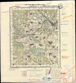
- Description:
- 1938
- Subject:
- Geographic Subject: Likhoslavl', Topical Subject: Soviet Union, and Topical Subject: Maps
- Publisher:
- Главное управление геодезии и картографии при СНК СССР
- Language:
- Russian
- Date Created:
- 1941
- Identifier:
- VAC9619-002852
- Genre:
- Military Maps and Topographic Maps
- Geographic Location:
- Coordinates: 57, 35.25, 57.167, 35.5
- Related URL:
- Download GeoTIFF: https://drive.google.com/file/d/1_1d7nZrOWqXaKo7w86AM92cd9KGEpK5Y/view?usp=sharing and Catalog URL: http://iucat.iu.edu/catalog/5020131
- Abstract:
- Modern area represented: Лихославль (Likhoslavl'), Тверская область (Tverskaya oblast), Russia
- Call Number:
- GM G7000 s50 .S68 sheet O-36-107-D
- City:
- Лихославль (Likhoslavl')
- Copyright Holder:
- No Copyright - United States
- Country:
- СССР (USSR)
- State/Province:
- Новоторжский район (Novotorzhsky district), Лихославльский район (Likhoslavlsky district), Калининская область (Kalinin oblast), and Медновский район (Mednov...
- Physical Description:
- Scale: 1:50,000
- Persistent URL:
- http://purl.dlib.indiana.edu/iudl/images/VAC9619/VAC9619-002852
- Provenance:
- M. I. Map Library
-
- Description:
- 1938
- Subject:
- Topical Subject: Soviet Union, Geographic Subject: Tereshkino, and Topical Subject: Maps
- Publisher:
- Главное управление геодезии и картографии при СНК СССР
- Language:
- Russian
- Date Created:
- 1941
- Identifier:
- VAC9619-002851
- Genre:
- Topographic Maps and Military Maps
- Geographic Location:
- Coordinates: 57, 35, 57.167, 35.25
- Related URL:
- Download GeoTIFF: https://drive.google.com/file/d/1ZxCCx26V9irbFiMxspZfiE2B2D0mKpmo/view?usp=sharing and Catalog URL: http://iucat.iu.edu/catalog/5020131
- Abstract:
- Modern area represented: Терешкино (Tereshkino), Тверская область (Tverskaya oblast), Russia
- Call Number:
- GM G7000 s50 .S68 sheet O-36-107-C
- Caption:
- Captured map
- City:
- Терешкино (Tereshkino)
- Copyright Holder:
- No Copyright - United States
- Country:
- СССР (USSR)
- State/Province:
- Калининская область (Kalinin oblast), Медновский район (Mednovsky district), Лихославльский район (Likhoslavlsky district), and Новоторжский район (Novotorzh...
- Physical Description:
- Scale: 1:50,000
- Persistent URL:
- http://purl.dlib.indiana.edu/iudl/images/VAC9619/VAC9619-002851
- Provenance:
- Army Map Service Library, OMAHA, Library of Congress Geography & Map Division
-
- Description:
- 1938
- Subject:
- Topical Subject: Soviet Union, Topical Subject: Maps, and Geographic Subject: Bol’shoye Ploskoye
- Publisher:
- Главное управление геодезии и картографии при СНК СССР
- Language:
- Russian
- Date Created:
- 1941
- Identifier:
- VAC9619-002850
- Genre:
- Topographic Maps and Military Maps
- Geographic Location:
- Coordinates: 57.167, 35.25, 57.333, 35.5
- Related URL:
- Catalog URL: http://iucat.iu.edu/catalog/5020131 and Download GeoTIFF: https://drive.google.com/file/d/1QbTVGhpTcwzq68sfhurfKNa6ZaCBc5b9/view?usp=sharing
- Abstract:
- Modern area represented: Большое Плоское (Bol’shoye Ploskoye), Тверская область (Tverskaya oblast), Russia
- Call Number:
- GM G7000 s50 .S68 sheet O-36-107-B
- Caption:
- Captured map
- City:
- Большое Плоское (Bol’shoye Ploskoye)
- Copyright Holder:
- No Copyright - United States
- Country:
- СССР (USSR)
- State/Province:
- Новоторжский район (Novotorzhsky district), Лихославльский район (Likhoslavlsky district), and Калининская область (Kalinin oblast)
- Physical Description:
- Scale: 1:50,000
- Persistent URL:
- http://purl.dlib.indiana.edu/iudl/images/VAC9619/VAC9619-002850
- Provenance:
- DMA Topographic Center, Army Map Service Library, OMAHA, Library of Congress Geography & Map Division
