
Search Constraints
You searched for:
Date Created
1941
Remove constraint Date Created: 1941
Provenance
M. I. Map Library
Remove constraint Provenance: M. I. Map Library
1 - 47 of 47
Search Results
-
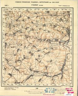
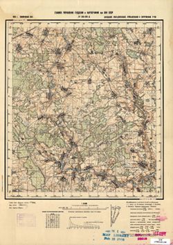
- Description:
- 1940
- Subject:
- Topical Subject: Soviet Union, Geographic Subject: Bolkhov, and Topical Subject: Maps
- Publisher:
- Главное Управление Геодезии и Картографии при СНК СССР
- Language:
- Russian
- Date Created:
- 1941
- Identifier:
- VAC9619-001478
- Genre:
- Military Maps and Topographic Maps
- Geographic Location:
- Coordinates: 53.3333, 35.75, 53.5, 36
- Related URL:
- Catalog URL: http://iucat.iu.edu/catalog/5020131 and Download GeoTIFF: https://drive.google.com/open?id=14GGU-2tZQhcnZj2XMD6SOTLnhCnhaWpk
- Abstract:
- Modern area represented: Bolkhov, Oryol oblast, Russia
- Call Number:
- G7000 s50 .S68 sheet N-36-96-D
- City:
- Болхов (Bolkhov)
- Copyright Holder:
- No Copyright - United States
- Country:
- СССР (USSR)
- State/Province:
- РСФСР (RSFSR) and Орловская область (Oryol oblast)
- Physical Description:
- Scale: 1:50,000
- Persistent URL:
- http://purl.dlib.indiana.edu/iudl/images/VAC9619/VAC9619-001478
- Provenance:
- M. I. Map Library
-
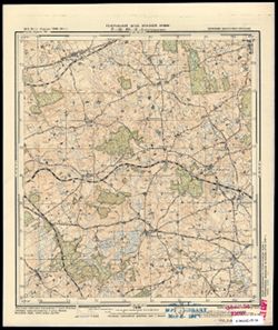
- Subject:
- Topical Subject: Soviet Union, Topical Subject: Maps, and Geographic Subject: Rogóż
- Publisher:
- Генеральный штаб Красной Армии
- Language:
- Russian
- Date Created:
- 1941
- Identifier:
- VAC9619-003811
- Genre:
- Military Maps and Topographic Maps
- Geographic Location:
- Coordinates: 54.083, 20.625, 54.1667, 20.75
- Related URL:
- Catalog URL: https://iucat.iu.edu/catalog/14701157 and Download GeoTIFF: https://drive.google.com/file/d/1giUT-j1OySHQI7HrtDK2bCgEnjETFz6O/view?usp=sharing
- Abstract:
- Modern area represented: Rogóż, Poland
- Call Number:
- G7063.K2 s25 .S6 sheet N-34-66-C-b
- City:
- Роггенхаузен (Roggenhausen)
- Copyright Holder:
- No Copyright - United States
- Country:
- Германия (Восточная Пруссия) (Germany (East Prussia))
- Physical Description:
- Scale: 1:25,000
- Persistent URL:
- http://purl.dlib.indiana.edu/iudl/images/VAC9619/VAC9619-003811
- Provenance:
- M. I. Map Library
-
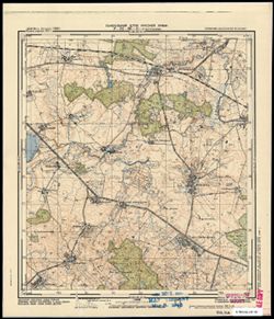
- Subject:
- Topical Subject: Soviet Union, Geographic Subject: Wiatrowiec, and Topical Subject: Maps
- Publisher:
- Генеральный штаб Красной Армии
- Language:
- Russian
- Date Created:
- 1941
- Identifier:
- VAC9619-003809
- Genre:
- Topographic Maps and Military Maps
- Geographic Location:
- Coordinates: 54.167, 20.875, 54.25, 21
- Related URL:
- Download GeoTIFF: https://drive.google.com/file/d/1vOh3ptGYLgaG2TVRWOZ5aB1k8PU4GEkW/view?usp=sharing and Catalog URL: https://iucat.iu.edu/catalog/14701157
- Abstract:
- Modern area represented: Wiatrowiec, Poland
- Call Number:
- G7063.K2 s25 .S6 sheet N-34-66-B-d
- City:
- Вотеркайм (Wöterkeim)
- Copyright Holder:
- No Copyright - United States
- Country:
- Германия (Восточная Пруссия) (Germany (East Prussia))
- Physical Description:
- Scale: 1:25,000
- Persistent URL:
- http://purl.dlib.indiana.edu/iudl/images/VAC9619/VAC9619-003809
- Provenance:
- M. I. Map Library
-
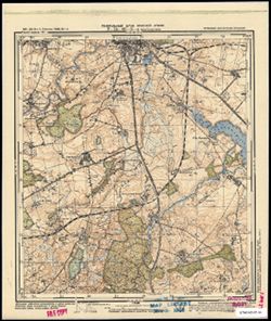
- Subject:
- Geographic Subject: Bartoszyce, Topical Subject: Soviet Union, and Topical Subject: Maps
- Publisher:
- Генеральный штаб Красной Армии
- Language:
- Russian
- Date Created:
- 1941
- Identifier:
- VAC9619-003808
- Genre:
- Topographic Maps and Military Maps
- Geographic Location:
- Coordinates: 54.1667, 20.75, 54.25, 20.875
- Related URL:
- Download GeoTIFF: https://drive.google.com/file/d/1HARliuMFQGrNYsBG8UYObEUh49nofFAd/view?usp=sharing and Catalog URL: https://iucat.iu.edu/catalog/14701157
- Abstract:
- Modern area represented: Bartoszyce, Poland (South side of the city)
- Call Number:
- G7063.K2 s25 .S6 sheet N-34-66-B-c
- City:
- Бартенштайн (Bartenstein)
- Copyright Holder:
- No Copyright - United States
- Country:
- Германия (Восточная Пруссия) (Germany (East Prussia))
- Physical Description:
- Scale: 1:25,000
- Persistent URL:
- http://purl.dlib.indiana.edu/iudl/images/VAC9619/VAC9619-003808
- Provenance:
- M. I. Map Library
-
- Subject:
- Topical Subject: Soviet Union, Topical Subject: Maps, and Geographic Subject: Judyty
- Publisher:
- Генеральный штаб Красной Армии
- Language:
- Russian
- Date Created:
- 1941
- Identifier:
- VAC9619-003807
- Genre:
- Military Maps and Topographic Maps
- Geographic Location:
- Coordinates: 54.25, 20.875, 54.333, 21
- Related URL:
- Download GeoTIFF: https://drive.google.com/file/d/1XHWlJDGtBe2K9Gnt_ge1gwDKiWKZCgIK/view?usp=sharing and Catalog URL: https://iucat.iu.edu/catalog/14701157
- Abstract:
- Modern area represented: Judyty, Poland
- Call Number:
- G7063.K2 s25 .S6 sheet N-34-66-B-b
- City:
- Юдиттен (Juditten)
- Copyright Holder:
- No Copyright - United States
- Country:
- Германия (Восточная Пруссия) (Germany (East Prussia))
- Physical Description:
- Scale: 1:25,000
- Persistent URL:
- http://purl.dlib.indiana.edu/iudl/images/VAC9619/VAC9619-003807
- Provenance:
- M. I. Map Library
-
- Subject:
- Topical Subject: Soviet Union, Geographic Subject: Rodnowo, and Topical Subject: Maps
- Publisher:
- Генеральный штаб Красной Армии
- Language:
- Russian
- Date Created:
- 1941
- Identifier:
- VAC9619-003805
- Genre:
- Topographic Maps and Military Maps
- Geographic Location:
- Coordinates: 54.167, 20.625, 54.25, 20.75
- Related URL:
- Catalog URL: https://iucat.iu.edu/catalog/14701157 and Download GeoTIFF: https://drive.google.com/file/d/16Hi8om-jODF3nfEOkWkWi5cVgvkVQ6WH/view?usp=sharing
- Abstract:
- Modern area represented: Rodnowo, Poland
- Call Number:
- G7063.K2 s25 .S6 sheet N-34-66-A-d
- City:
- Редденау (Reddenau)
- Copyright Holder:
- No Copyright - United States
- Country:
- Германия (Восточная Пруссия) (Germany (East Prussia))
- Physical Description:
- Scale: 1:25,000
- Persistent URL:
- http://purl.dlib.indiana.edu/iudl/images/VAC9619/VAC9619-003805
- Provenance:
- M. I. Map Library
-
- Subject:
- Topical Subject: Soviet Union, Geographic Subject: Wojciechy, and Topical Subject: Maps
- Publisher:
- Генеральный штаб Красной Армии
- Language:
- Russian
- Date Created:
- 1941
- Identifier:
- VAC9619-003804
- Genre:
- Topographic Maps and Military Maps
- Geographic Location:
- Coordinates: 54.25, 20.625, 54.333, 20.75
- Related URL:
- Download GeoTIFF: https://drive.google.com/file/d/11bGNN0cqZMWe8n97Ikl2o5o10LId_8HK/view?usp=sharing and Catalog URL: https://iucat.iu.edu/catalog/14701157
- Abstract:
- Modern area represented: Wojciechy, Poland
- Call Number:
- G7063.K2 s25 .S6 sheet N-34-66-A-b
- City:
- Альбрехтсдорф (Albrechtsdorf)
- Copyright Holder:
- No Copyright - United States
- Country:
- Германия (Восточная Пруссия) (Germany (East Prussia))
- Physical Description:
- Scale: 1:25,000
- Persistent URL:
- http://purl.dlib.indiana.edu/iudl/images/VAC9619/VAC9619-003804
- Provenance:
- M. I. Map Library
-
- Subject:
- Topical Subject: Maps, Geographic Subject: Kandyty, and Topical Subject: Soviet Union
- Publisher:
- Генеральный штаб Красной Армии
- Language:
- Russian
- Date Created:
- 1941
- Identifier:
- VAC9619-003798
- Genre:
- Topographic Maps and Military Maps
- Geographic Location:
- Coordinates: 54.25, 20.25, 54.33333, 20.375
- Related URL:
- Catalog URL: https://iucat.iu.edu/catalog/14701157 and Download GeoTIFF: https://drive.google.com/file/d/1S1W6QXdcqP7_Eu54P4qBVINF6B8bCYEK/view?usp=sharing
- Abstract:
- Modern area represented: Kandyty, Poland
- Call Number:
- G7063.K2 s25 .S6 sheet N-34-65-B-а
- City:
- Кандиттен (Kanditten)
- Copyright Holder:
- No Copyright - United States
- Country:
- Германия (Восточная Пруссия) (Germany (East Prussia))
- Physical Description:
- Scale: 1:25,000
- Persistent URL:
- http://purl.dlib.indiana.edu/iudl/images/VAC9619/VAC9619-003798
- Provenance:
- M. I. Map Library
-
- Subject:
- Topical Subject: Soviet Union, Geographic Subject: Janikowo, and Topical Subject: Maps
- Publisher:
- Генеральный штаб Красной Армии
- Language:
- Russian
- Date Created:
- 1941
- Identifier:
- VAC9619-003799
- Genre:
- Military Maps and Topographic Maps
- Geographic Location:
- Coordinates: 54.166667, 20.375, 54.25, 20.5
- Related URL:
- Download GeoTIFF: https://drive.google.com/file/d/1Xsw9w_3pOgyqqB2i9TaLhREcbeMMsS7h/view?usp=sharing and Catalog URL: https://iucat.iu.edu/catalog/14701157
- Abstract:
- Modern area represented: Janikowo, Poland
- Call Number:
- G7063.K2 s25 .S6 sheet N-34-65-B-d
- City:
- Хансхаген (Hanshagen)
- Copyright Holder:
- No Copyright - United States
- Country:
- Германия (Восточная Пруссия) (Germany (East Prussia))
- Physical Description:
- Scale: 1:25,000
- Persistent URL:
- http://purl.dlib.indiana.edu/iudl/images/VAC9619/VAC9619-003799
- Provenance:
- M. I. Map Library
-
- Subject:
- Topical Subject: Soviet Union, Topical Subject: Maps, and Geographic Subject: Ząbrowiec
- Publisher:
- Генеральный штаб Красной Армии
- Language:
- Russian
- Date Created:
- 1941
- Identifier:
- VAC9619-003797
- Genre:
- Topographic Maps and Military Maps
- Geographic Location:
- Coordinates: 54.0, 19.875, 54.083333, 20.0
- Related URL:
- Download GeoTIFF: https://drive.google.com/file/d/1nub9sHE446K5kjM5zIXU4yACyWY9K6dq/view?usp=sharing and Catalog URL: https://iucat.iu.edu/catalog/14701157
- Abstract:
- Modern area represented: Ząbrowiec, Poland
- Call Number:
- G7063.K2 s25 .S6 sheet N-34-64-D-d
- City:
- Зоммерфельд (Sommerfeld)
- Copyright Holder:
- No Copyright - United States
- Country:
- Германия (Восточная Пруссия) (Germany (East Prussia))
- Physical Description:
- Scale: 1:25,000
- Persistent URL:
- http://purl.dlib.indiana.edu/iudl/images/VAC9619/VAC9619-003797
- Provenance:
- M. I. Map Library
-
- Subject:
- Topical Subject: Maps, Topical Subject: Soviet Union, and Geographic Subject: Słobity
- Publisher:
- Генеральный штаб Красной Армии
- Language:
- Russian
- Date Created:
- 1941
- Identifier:
- VAC9619-003795
- Genre:
- Military Maps and Topographic Maps
- Geographic Location:
- Coordinates: 54.083333, 19.75, 54.166667, 19.875
- Related URL:
- Download GeoTIFF: https://drive.google.com/file/d/1wC6BkTBVCh1PKvinAe59WAy9VgPbh8fk/view?usp=sharing and Catalog URL: https://iucat.iu.edu/catalog/14701157
- Abstract:
- Modern area represented: Słobity, Poland
- Call Number:
- G7063.K2 s25 .S6 sheet N-34-64-D-а
- City:
- Шлобиттен (Schlobitten)
- Copyright Holder:
- No Copyright - United States
- Country:
- Германия (Восточная Пруссия) (Germany (East Prussia))
- Physical Description:
- Scale: 1:25,000
- Persistent URL:
- http://purl.dlib.indiana.edu/iudl/images/VAC9619/VAC9619-003795
- Provenance:
- M. I. Map Library
-
- Subject:
- Geographic Subject: Stegny, Topical Subject: Maps, and Topical Subject: Soviet Union
- Publisher:
- Генеральный штаб Красной Армии
- Language:
- Russian
- Date Created:
- 1941
- Identifier:
- VAC9619-003793
- Genre:
- Topographic Maps and Military Maps
- Geographic Location:
- Coordinates: 54.083333, 19.625, 54.166667, 19.75
- Related URL:
- Download GeoTIFF: https://drive.google.com/file/d/1RvAAMN_3Z1vv9PGObRxAZWE0wnLCm1EO/view?usp=sharing and Catalog URL: https://iucat.iu.edu/catalog/14701157
- Abstract:
- Modern area represented: Stegny, Poland
- Call Number:
- G7063.K2 s25 .S6 sheet N-34-31-C-b
- City:
- Штееген (Steegen)
- Copyright Holder:
- No Copyright - United States
- Country:
- Германия (Восточная Пруссия) (Germany (East Prussia))
- Physical Description:
- Scale: 1:25,000
- Persistent URL:
- http://purl.dlib.indiana.edu/iudl/images/VAC9619/VAC9619-003793
- Provenance:
- M. I. Map Library
-
- Subject:
- Topical Subject: Soviet Union, Topical Subject: Maps, and Geographic Subject: Stare Siedlisko
- Publisher:
- Генеральный штаб Красной Армии
- Language:
- Russian
- Date Created:
- 1941
- Identifier:
- VAC9619-003792
- Genre:
- Topographic Maps and Military Maps
- Geographic Location:
- Coordinates: 54.166667, 19.75, 54.25, 19.875
- Related URL:
- Download GeoTIFF: https://drive.google.com/file/d/1-NGFOGxtQ39d_ZGjH79l6Guy-5yjoHYB/view?usp=sharing and Catalog URL: https://iucat.iu.edu/catalog/14701157
- Abstract:
- Modern area represented: Stare Siedlisko, Poland
- Call Number:
- G7063.K2 s25 .S6 sheet N-34-64-B-c
- City:
- Эберсбах (Ebersbach)
- Copyright Holder:
- No Copyright - United States
- Country:
- Германия (Восточная Пруссия) (Germany (East Prussia))
- Physical Description:
- Scale: 1:25,000
- Persistent URL:
- http://purl.dlib.indiana.edu/iudl/images/VAC9619/VAC9619-003792
- Provenance:
- M. I. Map Library
-
- Subject:
- Topical Subject: Soviet Union, Geographic Subject: Jędrychowo, and Topical Subject: Maps
- Publisher:
- Генеральный штаб Красной Армии
- Language:
- Russian
- Date Created:
- 1941
- Identifier:
- VAC9619-003789
- Genre:
- Military Maps and Topographic Maps
- Geographic Location:
- Coordinates: 54.25, 19.625, 54.33333, 19.75
- Related URL:
- Download GeoTIFF: https://drive.google.com/file/d/12tRfmZ0TTV4HL8IO2CEf_0KU-rZwC8Jk/view?usp=sharing and Catalog URL: https://iucat.iu.edu/catalog/14701157
- Abstract:
- Modern area represented: Jędrychowo, Poland
- Call Number:
- G7063.K2 s25 .S6 sheet N-34-64-A-b
- City:
- Генрихсдорф (Heinrichsdorf)
- Copyright Holder:
- No Copyright - United States
- Country:
- Германия (Восточная Пруссия) (Germany (East Prussia))
- Physical Description:
- Scale: 1:25,000
- Persistent URL:
- http://purl.dlib.indiana.edu/iudl/images/VAC9619/VAC9619-003789
- Provenance:
- M. I. Map Library
-
- Subject:
- Geographic Subject: Malbork, Topical Subject: Maps, and Topical Subject: Soviet Union
- Publisher:
- Генеральный штаб Красной Армии
- Language:
- Russian
- Date Created:
- 1941
- Identifier:
- VAC9619-003786
- Genre:
- Military Maps and Topographic Maps
- Geographic Location:
- Coordinates: 54, 19, 54.083, 19.125
- Related URL:
- Download GeoTIFF: https://drive.google.com/file/d/1Xzrws6cS9eLG23FZwKy0nV4LiGJBCcRv/view?usp=sharing and Catalog URL: https://iucat.iu.edu/catalog/14701157
- Abstract:
- Modern area represented: Malbork, Poland
- Call Number:
- G7063.K2 s25 .S6 sheet N-34-63-C-c
- City:
- Мариенбург
- Copyright Holder:
- No Copyright - United States
- Country:
- Германия (Germany)
- Physical Description:
- Scale: 1:25,000
- Persistent URL:
- http://purl.dlib.indiana.edu/iudl/images/VAC9619/VAC9619-003786
- Provenance:
- M. I. Map Library
-
- Subject:
- Topical Subject: Maps, Topical Subject: Soviet Union, and Geographic Subject: Myszewo
- Publisher:
- Генеральный штаб Красной Армии
- Language:
- Russian
- Date Created:
- 1941
- Identifier:
- VAC9619-003785
- Genre:
- Topographic Maps and Military Maps
- Geographic Location:
- Coordinates: 54.083, 19.125, 54.167, 19.25
- Related URL:
- Catalog URL: https://iucat.iu.edu/catalog/14701157 and Download GeoTIFF: https://drive.google.com/file/d/1XadLTRStSNFshiBzZCO9r5wCAhaLTYqy/view?usp=sharing
- Abstract:
- Modern area represented: Myszewo, Poland
- Call Number:
- G7063.K2 s25 .S6 sheet N-34-63-C-b
- City:
- Гросс Маусдорф (Gross Mausdorf)
- Copyright Holder:
- No Copyright - United States
- Country:
- Германия (Germany)
- Physical Description:
- Scale: 1:25,000
- Persistent URL:
- http://purl.dlib.indiana.edu/iudl/images/VAC9619/VAC9619-003785
- Provenance:
- M. I. Map Library
-
- Subject:
- Topical Subject: Maps, Geographic Subject: Elbląg, and Topical Subject: Soviet Union
- Publisher:
- Генеральный штаб Красной Армии
- Language:
- Russian
- Date Created:
- 1941
- Identifier:
- VAC9619-003783
- Genre:
- Military Maps and Topographic Maps
- Geographic Location:
- Coordinates: 54.167, 19.375, 54.25, 19.5
- Related URL:
- Download GeoTIFF: https://drive.google.com/file/d/1b2kxp8Acq6JkNcncigxWSdLSKx7IK959/view?usp=sharing and Catalog URL: https://iucat.iu.edu/catalog/14701157
- Abstract:
- Modern area represented: part of Elbląg, Poland
- Call Number:
- G7063.K2 s25 .S6 sheet N-34-63-B-d
- City:
- Пангриц-Кол (Pangritz-Kolonie)
- Copyright Holder:
- No Copyright - United States
- Country:
- Германия (Germany)
- Physical Description:
- Scale: 1:25,000
- Persistent URL:
- http://purl.dlib.indiana.edu/iudl/images/VAC9619/VAC9619-003783
- Provenance:
- M. I. Map Library
-
- Subject:
- Topical Subject: Soviet Union, Topical Subject: Maps, and Geographic Subject: Lipowina
- Publisher:
- Генеральный штаб Красной Армии
- Language:
- Russian
- Date Created:
- 1941
- Identifier:
- VAC9619-003734
- Genre:
- Military Maps and Topographic Maps
- Geographic Location:
- Coordinates: 54.3333, 19.875, 54.416667, 20.0
- Related URL:
- Catalog URL: https://iucat.iu.edu/catalog/14701157 and Download GeoTIFF: https://drive.google.com/file/d/1l96vc4j5V2LoLfZCs-VZ4Em6p8VoKhLa/view?usp=sharing
- Abstract:
- Modern area represented: Lipowina, Poland
- Call Number:
- G7063.K2 s25 .S6 sheet N-34-52-D-d
- City:
- Линденау (Lindenau)
- Copyright Holder:
- No Copyright - United States
- Country:
- Германия (Восточная Пруссия) (Germany (East Prussia))
- Physical Description:
- Scale: 1:25,000
- Persistent URL:
- http://purl.dlib.indiana.edu/iudl/images/VAC9619/VAC9619-003734
- Provenance:
- M. I. Map Library
-
- Subject:
- Topical Subject: Maps, Topical Subject: Soviet Union, and Geographic Subject: Przebrno
- Publisher:
- Генеральный штаб Красной Армии
- Language:
- Russian
- Date Created:
- 1941
- Identifier:
- VAC9619-003726
- Genre:
- Military Maps and Topographic Maps
- Geographic Location:
- Coordinates: 54.333, 19.25, 54.417, 19.375
- Related URL:
- Download GeoTIFF: https://drive.google.com/file/d/1CLV6-QjLkr3uyiNtmTa1PIy0iQBKYM80/view?usp=sharing and Catalog URL: https://iucat.iu.edu/catalog/14701157
- Abstract:
- Modern area represented: Przebrno, part of the town of Krynica Morska, Poland
- Call Number:
- G7063.K2 s25 .S6 sheet N-34-51-D-c
- City:
- Преббернау (Pröbbernau)
- Copyright Holder:
- No Copyright - United States
- Country:
- Германия (Germany)
- Physical Description:
- Scale: 1:25,000
- Persistent URL:
- http://purl.dlib.indiana.edu/iudl/images/VAC9619/VAC9619-003726
- Provenance:
- M. I. Map Library
-
- Subject:
- Geographic Subject: Kąty Rybackie, Topical Subject: Soviet Union, and Topical Subject: Maps
- Publisher:
- Генеральный штаб Красной Армии
- Language:
- Russian
- Date Created:
- 1941
- Identifier:
- VAC9619-003725
- Genre:
- Topographic Maps and Military Maps
- Geographic Location:
- Coordinates: 54.333, 19.125, 54.417, 19.25
- Related URL:
- Download GeoTIFF: https://drive.google.com/file/d/1nthUYSIAKdjoclMMA8ArWuM2ha_r6Ch6/view?usp=sharing and Catalog URL: https://iucat.iu.edu/catalog/14701157
- Abstract:
- Modern area represented: Kąty Rybackie, Poland
- Call Number:
- G7063.K2 s25 .S6 sheet N-34-51-C-d
- City:
- Боденвинкель (Bodenwinkel)
- Copyright Holder:
- No Copyright - United States
- Country:
- Германия (Germany)
- Physical Description:
- Scale: 1:25,000
- Persistent URL:
- http://purl.dlib.indiana.edu/iudl/images/VAC9619/VAC9619-003725
- Provenance:
- M. I. Map Library
-
- Subject:
- Geographic Subject: Jantar, Topical Subject: Soviet Union, and Topical Subject: Maps
- Publisher:
- Генеральный штаб Красной Армии
- Language:
- Russian
- Date Created:
- 1941
- Identifier:
- VAC9619-003724
- Genre:
- Military Maps and Topographic Maps
- Geographic Location:
- Coordinates: 54.333, 19, 54.417, 19.125
- Related URL:
- Catalog URL: https://iucat.iu.edu/catalog/14701157 and Download GeoTIFF: https://drive.google.com/file/d/1XRXsOHSWk3V6ILdyPhcAPZc9s4tg6S4w/view?usp=sharing
- Abstract:
- Modern area represented: Jantar, Poland
- Call Number:
- G7063.K2 s25 .S6 sheet N-34-51-C-c
- City:
- Пазеварк (Pasewark)
- Copyright Holder:
- No Copyright - United States
- Country:
- Германия (Germany)
- Physical Description:
- Scale: 1:25,000
- Persistent URL:
- http://purl.dlib.indiana.edu/iudl/images/VAC9619/VAC9619-003724
- Provenance:
- M. I. Map Library
-
- Subject:
- Topical Subject: Soviet Union, Geographic Subject: Veiveriai, and Topical Subject: Maps
- Publisher:
- Генеральный штаб Красной Армии
- Language:
- Russian
- Date Created:
- 1941
- Identifier:
- VAC9619-003723
- Genre:
- Military Maps and Topographic Maps
- Geographic Location:
- Coordinates: 54.75, 23.625, 54.875, 23.75
- Related URL:
- Catalog URL: https://iucat.iu.edu/catalog/14701157 and Download GeoTIFF: https://drive.google.com/file/d/1nnb2K3KSqYEadwS2uEuWXtn2wrG-yvPS/view?usp=sharing
- Abstract:
- Modern area represented: Veiveriai, Lithuania
- Call Number:
- G7063.K2 s25 .S6 sheet N-34-48-C-b
- Caption:
- Секретно
- City:
- Вейверы (Veyvery)
- Copyright Holder:
- No Copyright - United States
- Country:
- СССР (USSR)
- State/Province:
- Литовская ССР (Lithuanian Soviet Socialist Republic)
- Physical Description:
- Scale: 1:25,000
- Persistent URL:
- http://purl.dlib.indiana.edu/iudl/images/VAC9619/VAC9619-003723
- Provenance:
- M. I. Map Library
-
- Subject:
- Geographic Subject: Zarechnoye, Topical Subject: Soviet Union, and Topical Subject: Maps
- Publisher:
- Генеральный штаб Красной Армии
- Language:
- Russian
- Date Created:
- 1941
- Identifier:
- VAC9619-003715
- Genre:
- Military Maps and Topographic Maps
- Geographic Location:
- Coordinates: 54.913, 22.5, 55, 22.625
- Related URL:
- Download GeoTIFF: https://drive.google.com/file/d/10eG9i42MpkClt--V5t-j-ytSukxmz6k4/view?usp=sharing and Catalog URL: https://iucat.iu.edu/catalog/14701157
- Abstract:
- Modern area represented: Заречное (Zarechnoye), Kaliningradskaya oblast, Russia
- Call Number:
- G7063.K2 s25 .S6 sheet N-34-46-A-а
- City:
- Тульпенингкен (Tulpeningen)
- Copyright Holder:
- No Copyright - United States
- Country:
- Германия (Восточная Пруссия) (Germany (East Prussia))
- Physical Description:
- Scale: 1:25,000
- Persistent URL:
- http://purl.dlib.indiana.edu/iudl/images/VAC9619/VAC9619-003715
- Provenance:
- M. I. Map Library
-
- Subject:
- Topical Subject: Maps, Topical Subject: Soviet Union, and Geographic Subject: Sadovo
- Publisher:
- Генеральный штаб Красной Армии
- Language:
- Russian
- Date Created:
- 1941
- Identifier:
- VAC9619-003703
- Genre:
- Topographic Maps and Military Maps
- Geographic Location:
- Coordinates: 54.913, 22.25, 55, 22.375
- Related URL:
- Download GeoTIFF: https://drive.google.com/file/d/10iUEVq-FgpW5LynQxDoxk2CNlPPyJLON/view?usp=sharing and Catalog URL: https://iucat.iu.edu/catalog/14701157
- Abstract:
- Modern area represented: Садово (Sadovo), Kaliningradskaya oblast, Russia
- Call Number:
- G7063.K2 s25 .S6 sheet N-34-45-B-а
- City:
- Гросс Какшен (Gross Kackschen)
- Copyright Holder:
- No Copyright - United States
- Country:
- Германия (Восточная Пруссия) (Germany (East Prussia))
- Physical Description:
- Scale: 1:25,000
- Persistent URL:
- http://purl.dlib.indiana.edu/iudl/images/VAC9619/VAC9619-003703
- Provenance:
- M. I. Map Library
-
- Subject:
- Geographic Subject: Zhavoronkovo, Topical Subject: Soviet Union, and Topical Subject: Maps
- Publisher:
- Генеральный штаб Красной Армии
- Language:
- Russian
- Date Created:
- 1941
- Identifier:
- VAC9619-003693
- Genre:
- Military Maps and Topographic Maps
- Geographic Location:
- Coordinates: 54.667, 21.5, 54.75, 21.625
- Related URL:
- Catalog URL: https://iucat.iu.edu/catalog/14701157 and Download GeoTIFF: https://drive.google.com/file/d/1i7SF1HsBPrb0Xz9onIUpt1lUQCrBxhmm/view?usp=sharing
- Abstract:
- Modern area represented: Жаворонково (Zhavoronkovo), Kaliningradskaya oblast, Russia
- Call Number:
- G7063.K2 s25 .S6 sheet N-34-44-C-c
- City:
- Вирбельн (Wirbeln)
- Copyright Holder:
- No Copyright - United States
- Country:
- Германия (Восточная Пруссия) (Germany (East Prussia))
- Physical Description:
- Scale: 1:25,000
- Persistent URL:
- http://purl.dlib.indiana.edu/iudl/images/VAC9619/VAC9619-003693
- Provenance:
- M. I. Map Library
-
- Subject:
- Geographic Subject: Dal’neye, Topical Subject: Soviet Union, and Topical Subject: Maps
- Publisher:
- Генеральный штаб Красной Армии
- Language:
- Russian
- Date Created:
- 1941
- Identifier:
- VAC9619-003682
- Genre:
- Topographic Maps and Military Maps
- Geographic Location:
- Coordinates: 54.667, 21.375, 54.75, 21.5
- Related URL:
- Download GeoTIFF: https://drive.google.com/file/d/1fTPSe9vUbCgau3cmo7T1FQmyVqS7pERj/view?usp=sharing and Catalog URL: https://iucat.iu.edu/catalog/14701157
- Abstract:
- Modern area represented: Дальнее (Dal’neye), Kaliningradskaya oblast, Russia
- Call Number:
- G7063.K2 s25 .S6 sheet N-34-33-A-а
- City:
- Гросс Ширрау (Gross Shirrau)
- Copyright Holder:
- No Copyright - United States
- Country:
- Германия (Восточная Пруссия) (Germany (East Prussia))
- Physical Description:
- Scale: 1:25,000
- Persistent URL:
- http://purl.dlib.indiana.edu/iudl/images/VAC9619/VAC9619-003682
- Provenance:
- M. I. Map Library
-
- Subject:
- Topical Subject: Soviet Union, Topical Subject: Maps, and Geographic Subject: Novaya Derevnya
- Publisher:
- Генеральный штаб Красной Армии
- Language:
- Russian
- Date Created:
- 1941
- Identifier:
- VAC9619-003678
- Genre:
- Military Maps and Topographic Maps
- Geographic Location:
- Coordinates: 54.75, 21.25, 54.833, 21.375
- Related URL:
- Catalog URL: https://iucat.iu.edu/catalog/14701157 and Download GeoTIFF: https://drive.google.com/file/d/1U7avOM14qw5dWSGMG3AEw1GOyD8z68Hk/view?usp=sharing
- Abstract:
- Modern area represented: part of Новая Деревня (Novaya Derevnya), Kaliningradskaya oblast, Russia
- Call Number:
- G7063.K2 s25 .S6 sheet N-34-43-D-а
- City:
- Альт Гертлаукен (Al’t Gertlauken)
- Copyright Holder:
- No Copyright - United States
- Country:
- Германия (Восточная Пруссия) (Germany (East Prussia))
- Physical Description:
- Scale: 1:25,000
- Persistent URL:
- http://purl.dlib.indiana.edu/iudl/images/VAC9619/VAC9619-003678
- Provenance:
- M. I. Map Library
-
- Subject:
- Topical Subject: Maps, Geographic Subject: Soldatovo, and Topical Subject: Soviet Union
- Publisher:
- Генеральный штаб Красной Армии
- Language:
- Russian
- Date Created:
- 1941
- Identifier:
- VAC9619-003677
- Genre:
- Topographic Maps and Military Maps
- Geographic Location:
- Coordinates: 54.667, 21.125, 54.75, 21.25
- Related URL:
- Download GeoTIFF: https://drive.google.com/file/d/10gu0Oy_k3czoJLMC7tZ6T3pnWCdUUhef/view?usp=sharing and Catalog URL: https://iucat.iu.edu/catalog/14701157
- Abstract:
- Modern area represented: part of Солдатово (Soldatovo), Kaliningradskaya oblast, Russia
- Call Number:
- G7063.K2 s25 .S6 sheet N-34-43-C-d
- City:
- Грюнхайн (Grünhayn)
- Copyright Holder:
- No Copyright - United States
- Country:
- Германия (Восточная Пруссия) (Germany (East Prussia))
- Physical Description:
- Scale: 1:25,000
- Persistent URL:
- http://purl.dlib.indiana.edu/iudl/images/VAC9619/VAC9619-003677
- Provenance:
- M. I. Map Library
-
- Subject:
- Geographic Subject: Slavinsk, Topical Subject: Soviet Union, and Topical Subject: Maps
- Publisher:
- Генеральный штаб Красной Армии
- Language:
- Russian
- Date Created:
- 1941
- Identifier:
- VAC9619-003676
- Genre:
- Military Maps and Topographic Maps
- Geographic Location:
- Coordinates: 54.667, 21, 54.75, 21.125
- Related URL:
- Catalog URL: https://iucat.iu.edu/catalog/14701157 and Download GeoTIFF: https://drive.google.com/file/d/1gRLZFdaBf22L1TDKVw_SCbBarDatuvNm/view?usp=sharing
- Abstract:
- Modern area represented: Славинск (Slavinsk), Kaliningradskaya oblast, Russia
- Call Number:
- G7063.K2 s25 .S6 sheet N-34-43-C-c
- City:
- Гольдбах (Goldbach)
- Copyright Holder:
- No Copyright - United States
- Country:
- Германия (Восточная Пруссия) (Germany (East Prussia))
- Physical Description:
- Scale: 1:25,000
- Persistent URL:
- http://purl.dlib.indiana.edu/iudl/images/VAC9619/VAC9619-003676
- Provenance:
- M. I. Map Library
-
- Subject:
- Topical Subject: Maps, Geographic Subject: Saranskoye, and Topical Subject: Soviet Union
- Publisher:
- Генеральный штаб Красной Армии
- Language:
- Russian
- Date Created:
- 1941
- Identifier:
- VAC9619-003675
- Genre:
- Topographic Maps and Military Maps
- Geographic Location:
- Coordinates: 54.75, 21.125, 54.833, 21.25
- Related URL:
- Catalog URL: https://iucat.iu.edu/catalog/14701157 and Download GeoTIFF: https://drive.google.com/file/d/171J2h06alEDwAoKYLkxxUETL9PCWy2T_/view?usp=sharing
- Abstract:
- Modern area represented: Саранское (Saranskoye), Kaliningradskaya oblast, Russia
- Call Number:
- G7063.K2 s25 .S6 sheet N-34-43-C-b
- City:
- Адлиг Лаукишкен (Laukischken)
- Copyright Holder:
- No Copyright - United States
- Country:
- Германия (Восточная Пруссия) (Germany (East Prussia))
- Physical Description:
- Scale: 1:25,000
- Persistent URL:
- http://purl.dlib.indiana.edu/iudl/images/VAC9619/VAC9619-003675
- Provenance:
- M. I. Map Library
-
- Subject:
- Geographic Subject: Lomonosovka, Topical Subject: Maps, and Topical Subject: Soviet Union
- Publisher:
- Генеральный штаб Красной Армии
- Language:
- Russian
- Date Created:
- 1941
- Identifier:
- VAC9619-003672
- Genre:
- Topographic Maps and Military Maps
- Geographic Location:
- Coordinates: 54.833, 21.125, 54.913, 21.25
- Related URL:
- Catalog URL: https://iucat.iu.edu/catalog/14701157 and Download GeoTIFF: https://drive.google.com/file/d/1KbemoLtvF_QNGS2me7BY7LTnpuylU4jM/view?usp=sharing
- Abstract:
- Modern area represented: Ломоносовка (Lomonosovka), Kaliningradskaya oblast, Russia
- Call Number:
- G7063.K2 s25 .S6 sheet N-34-43-A-d
- City:
- Пермауэрн (Permauern)
- Copyright Holder:
- No Copyright - United States
- Country:
- Германия (Восточная Пруссия) (Germany (East Prussia))
- Physical Description:
- Scale: 1:25,000
- Persistent URL:
- http://purl.dlib.indiana.edu/iudl/images/VAC9619/VAC9619-003672
- Provenance:
- M. I. Map Library
-
- Description:
- 1911
- Subject:
- Topical Subject: Maps, Geographic Subject: Golovkino, and Topical Subject: Soviet Union
- Publisher:
- Генеральный штаб Красной Армии
- Language:
- Russian
- Date Created:
- 1941
- Identifier:
- VAC9619-003671
- Genre:
- Military Maps and Topographic Maps
- Geographic Location:
- Coordinates: 54.917, 21.25, 55, 21.375
- Related URL:
- Catalog URL: https://iucat.iu.edu/catalog/14701157 and Download GeoTIFF: https://drive.google.com/file/d/1AmzMH5QdUhv_5_ZfM5R8QW2A0J9xhf0k/view?usp=sharing
- Abstract:
- Modern area represented: Головкино (Golovkino), Kaliningradskaya oblast, Russia
- Call Number:
- G7063.K2 s25 .S6 sheet N-34-43-B-а
- City:
- Немонин (Nemonien)
- Copyright Holder:
- No Copyright - United States
- Country:
- Германия (Восточная Пруссия) (Germany (East Prussia))
- Physical Description:
- Scale: 1:25,000
- Persistent URL:
- http://purl.dlib.indiana.edu/iudl/images/VAC9619/VAC9619-003671
- Provenance:
- M. I. Map Library
-
- Subject:
- Topical Subject: Soviet Union, Topical Subject: Maps, and Geographic Subject: Razino
- Publisher:
- Генеральный штаб Красной Армии
- Language:
- Russian
- Date Created:
- 1941
- Identifier:
- VAC9619-003669
- Genre:
- Military Maps and Topographic Maps
- Geographic Location:
- Coordinates: 54.913, 21.125, 55, 21.25
- Related URL:
- Download GeoTIFF: https://drive.google.com/file/d/1fLWJeggH3IsUz9WOxHkkNTDHHx_spD3j/view?usp=sharing and Catalog URL: https://iucat.iu.edu/catalog/14701157
- Abstract:
- Modern area represented: Разино (Razino), Kaliningradskaya oblast, Russia
- Call Number:
- G7063.K2 s25 .S6 sheet N-34-43-A-b
- City:
- Ювендт (Juwendt)
- Copyright Holder:
- No Copyright - United States
- Country:
- Германия (Восточная Пруссия) (Germany (East Prussia))
- Physical Description:
- Scale: 1:25,000
- Persistent URL:
- http://purl.dlib.indiana.edu/iudl/images/VAC9619/VAC9619-003669
- Provenance:
- M. I. Map Library
-
- Subject:
- Topical Subject: Soviet Union, Topical Subject: Maps, and Geographic Subject: Didieji Ibėnai
- Publisher:
- Генеральный штаб Красной Армии
- Language:
- Russian
- Date Created:
- 1941
- Identifier:
- VAC9619-003635
- Genre:
- Military Maps and Topographic Maps
- Geographic Location:
- Coordinates: 55, 23.875, 55.083, 24
- Related URL:
- Catalog URL: https://iucat.iu.edu/catalog/14701157 and Download GeoTIFF: https://drive.google.com/file/d/1tupUHbpChdC5mnOsJmV22NSUxvuLLwGp/view?usp=sharing
- Abstract:
- Modern area represented: Didieji Ibėnai, Lithuania
- Call Number:
- G7063.K2 s25 .S6 sheet N-34-36-D-d
- Caption:
- Секретно
- City:
- Никольская (Nikol’skaya)
- Copyright Holder:
- No Copyright - United States
- Country:
- СССР (USSR)
- State/Province:
- Литовская ССР (Lithuanian Soviet Socialist Republic)
- Physical Description:
- Scale: 1:25,000
- Persistent URL:
- http://purl.dlib.indiana.edu/iudl/images/VAC9619/VAC9619-003635
- Provenance:
- M. I. Map Library
-
- Subject:
- Topical Subject: Maps, Topical Subject: Soviet Union, and Geographic Subject: Muniškiai
- Publisher:
- Генеральный штаб Красной Армии
- Language:
- Russian
- Date Created:
- 1941
- Identifier:
- VAC9619-003634
- Genre:
- Military Maps and Topographic Maps
- Geographic Location:
- Coordinates: 55, 23.75, 55.083, 23.875
- Related URL:
- Download GeoTIFF: https://drive.google.com/file/d/1RSHjF8sA7nONXJFs4vMmAN6eP3uezOJd/view?usp=sharing and Catalog URL: https://iucat.iu.edu/catalog/14701157
- Abstract:
- Modern area represented: Muniškiai, Lithuania
- Call Number:
- G7063.K2 s25 .S6 sheet N-34-36-D-c
- Caption:
- Секретно
- City:
- Мунишканцы (Munishkantsy)
- Copyright Holder:
- No Copyright - United States
- Country:
- СССР (USSR)
- State/Province:
- Литовская ССР (Lithuanian Soviet Socialist Republic)
- Physical Description:
- Scale: 1:25,000
- Persistent URL:
- http://purl.dlib.indiana.edu/iudl/images/VAC9619/VAC9619-003634
- Provenance:
- M. I. Map Library
-
- Subject:
- Topical Subject: Soviet Union, Geographic Subject: Lygainiai, and Topical Subject: Maps
- Publisher:
- Генеральный штаб Красной Армии
- Language:
- Russian
- Date Created:
- 1941
- Identifier:
- VAC9619-003631
- Genre:
- Military Maps and Topographic Maps
- Geographic Location:
- Coordinates: 55, 23.625, 55.083, 23.75
- Related URL:
- Download GeoTIFF: https://drive.google.com/file/d/1S2wLZFzyMw9G1AZTYyk76tctZv36Q1Ml/view?usp=sharing and Catalog URL: https://iucat.iu.edu/catalog/14701157
- Abstract:
- Modern area represented: Lygainiai, Lithuania
- Call Number:
- G7063.K2 s25 .S6 sheet N-34-36-C-d
- Caption:
- Секретно
- City:
- Лигайне (Ligayne)
- Copyright Holder:
- No Copyright - United States
- Country:
- СССР (USSR)
- State/Province:
- Литовская ССР (Lithuanian Soviet Socialist Republic)
- Physical Description:
- Scale: 1:25,000
- Persistent URL:
- http://purl.dlib.indiana.edu/iudl/images/VAC9619/VAC9619-003631
- Provenance:
- M. I. Map Library
-
- Subject:
- Topical Subject: Soviet Union and Topical Subject: Maps
- Publisher:
- Генеральный штаб Красной Армии
- Language:
- Russian
- Date Created:
- 1941
- Identifier:
- VAC9619-003610
- Genre:
- Topographic Maps and Military Maps
- Geographic Location:
- Coordinates: 55.083, 21.75, 55.167, 21.875
- Related URL:
- Catalog URL: https://iucat.iu.edu/catalog/14701157 and Download GeoTIFF: https://drive.google.com/file/d/1R9_sJzyUDMnr8lrmdZvvsQeJpRJJRUid/view?usp=sharing
- Abstract:
- Modern area represented: part of Советск (Sovetsk) (?), Kaliningradskaya oblast, Russia
- Call Number:
- G7063.K2 s25 .S6 sheet N-34-32-D-a
- City:
- Штолбек
- Copyright Holder:
- No Copyright - United States
- Country:
- Германия (Восточная Пруссия) (Germany (East Prussia))
- Physical Description:
- Scale: 1:25,000
- Persistent URL:
- http://purl.dlib.indiana.edu/iudl/images/VAC9619/VAC9619-003610
- Provenance:
- M. I. Map Library
-
- Subject:
- Topical Subject: Maps, Geographic Subject: Usėnai, and Topical Subject: Soviet Union
- Publisher:
- Генеральный штаб Красной Армии
- Language:
- Russian
- Date Created:
- 1941
- Identifier:
- VAC9619-003604
- Genre:
- Military Maps and Topographic Maps
- Geographic Location:
- Coordinates: 55.167, 21.625, 55.25, 21.75
- Related URL:
- Download GeoTIFF: https://drive.google.com/file/d/1ILW9UdHMeTHllNX08KgFPtp4sluLbiD6/view?usp=sharing and Catalog URL: https://iucat.iu.edu/catalog/14701157
- Abstract:
- Modern area represented: Usėnai, Lithuania
- Call Number:
- G7063.K2 s25 .S6 sheet N-34-32-A-d
- City:
- Мэдевальд (Mädewald)
- Copyright Holder:
- No Copyright - United States
- Country:
- Германия (Восточная Пруссия) (Germany (East Prussia))
- Physical Description:
- Scale: 1:25,000
- Persistent URL:
- http://purl.dlib.indiana.edu/iudl/images/VAC9619/VAC9619-003604
- Provenance:
- M. I. Map Library
-
- Subject:
- Topical Subject: Maps, Topical Subject: Soviet Union, and Geographic Subject: Yasnoye
- Publisher:
- Генеральный штаб Красной Армии
- Language:
- Russian
- Date Created:
- 1941
- Identifier:
- VAC9619-003603
- Genre:
- Topographic Maps and Military Maps
- Geographic Location:
- Coordinates: 55.167, 21.5, 55.25, 21.625
- Related URL:
- Download GeoTIFF: https://drive.google.com/file/d/1mN5NdriMOpVPw3f77-YKlWI7E37I_SUW/view?usp=sharing and Catalog URL: https://iucat.iu.edu/catalog/14701157
- Abstract:
- Modern area represented: Ясное (Yasnoye), Kaliningradskaya oblast, Russia
- Call Number:
- G7063.K2 s25 .S6 sheet N-34-32-A-c
- City:
- Каукемен (Kaukemen)
- Copyright Holder:
- No Copyright - United States
- Country:
- Германия (Восточная Пруссия) (Germany (East Prussia))
- Physical Description:
- Scale: 1:25,000
- Persistent URL:
- http://purl.dlib.indiana.edu/iudl/images/VAC9619/VAC9619-003603
- Provenance:
- M. I. Map Library
-
- Subject:
- Geographic Subject: Krakės, Topical Subject: Soviet Union, and Topical Subject: Maps
- Publisher:
- Генеральный штаб Красной Армии
- Language:
- Russian
- Date Created:
- 1941
- Identifier:
- VAC9619-003583
- Genre:
- Topographic Maps and Military Maps
- Geographic Location:
- Coordinates: 55.333, 23.625, 55.417, 23.75
- Related URL:
- Download GeoTIFF: https://drive.google.com/file/d/19Cr2qI4RqBkehkyBa1nvsuagjpFFQlbF/view?usp=sharing and Catalog URL: https://iucat.iu.edu/catalog/14701157
- Abstract:
- Modern area represented: Krakės, Lithuania
- Call Number:
- G7063.K2 s25 .S6 sheet N-34-24-C-d
- Caption:
- Секретно
- City:
- Кроки (Kroki)
- Copyright Holder:
- No Copyright - United States
- Country:
- СССР (USSR)
- State/Province:
- Литовская ССР (Lithuanian Soviet Socialist Republic)
- Physical Description:
- Scale: 1:25,000
- Persistent URL:
- http://purl.dlib.indiana.edu/iudl/images/VAC9619/VAC9619-003583
- Provenance:
- M. I. Map Library
-
- Description:
- 1936
- Subject:
- Topical Subject: Maps, Topical Subject: Soviet Union, and Geographic Subject: Glad'
- Publisher:
- Главное управление государственной съемки и картографии НКВД СССР
- Language:
- Russian
- Date Created:
- 1941
- Identifier:
- VAC9619-003326
- Genre:
- Military Maps and Topographic Maps
- Geographic Location:
- Coordinates: 59, 32, 59.167, 32.25
- Related URL:
- Catalog URL: http://iucat.iu.edu/catalog/5020131 and Download GeoTIFF: https://drive.google.com/file/d/1uQeqSrfffRYdboAdTqPVTHEerJ_HHoQF/view?usp=sharing
- Abstract:
- Modern area represented: Гладь (Glad'), Novgorodskaya oblast, Russia
- Call Number:
- G7000 s50 .S68 sheet O-36-29-C
- Caption:
- Для служебного пользования
- City:
- Гладь (Glad')
- Copyright Holder:
- No Copyright - United States
- Country:
- СССР (USSR)
- State/Province:
- Чудовский район (Chudovsky district), Маловишерский район (Malovishersky district), РСФСР (RSFSR), and Ленинградская область (Leningrad oblast)
- Physical Description:
- Scale: 1:50,000
- Persistent URL:
- http://purl.dlib.indiana.edu/iudl/images/VAC9619/VAC9619-003326
- Provenance:
- M. I. Map Library
-
- Description:
- 1937
- Subject:
- Topical Subject: Maps, Geographic Subject: Vditsko, and Topical Subject: Soviet Union
- Publisher:
- Главное управление государственной съемки и картографии НКВД СССР
- Language:
- Russian
- Date Created:
- 1941
- Identifier:
- VAC9619-003317
- Genre:
- Military Maps and Topographic Maps
- Geographic Location:
- Coordinates: 59, 31, 59.167, 31.25
- Related URL:
- Catalog URL: http://iucat.iu.edu/catalog/5020131 and Download GeoTIFF: https://drive.google.com/file/d/1NM_x_MjJDqMX13qR8VPd7sFKdkVst2LK/view?usp=sharing
- Abstract:
- Modern area represented: Вдицко (Vditsko), Novgorodskaya oblast, Russia
- Call Number:
- G7000 s50 .S68 sheet O-36-27-C
- Caption:
- Captured map and Секретно
- City:
- Вдицко (Vditsko)
- Copyright Holder:
- No Copyright - United States
- Country:
- СССР (USSR)
- State/Province:
- РСФСР (RSFSR), Тосненский район (Tosnensky district), Ленинградская область (Leningrad oblast), and Новгородский район (Novgorod district)
- Physical Description:
- Scale: 1:50,000
- Persistent URL:
- http://purl.dlib.indiana.edu/iudl/images/VAC9619/VAC9619-003317
- Provenance:
- M. I. Map Library
-
- Description:
- 1938
- Subject:
- Topical Subject: Maps, Topical Subject: Soviet Union, and Geographic Subject: Polomenitsy
- Publisher:
- Главное управление геодезии и картографии при СНК СССР
- Language:
- Russian
- Date Created:
- 1941
- Identifier:
- VAC9619-002904
- Genre:
- Military Maps and Topographic Maps
- Geographic Location:
- Coordinates: 56.667, 35, 56.833, 35.25
- Related URL:
- Catalog URL: http://iucat.iu.edu/catalog/5020131 and Download GeoTIFF: https://drive.google.com/file/d/1_WPD2YySqDnn5ZOBE2eLEB6FMHHGimLb/view?usp=sharing
- Abstract:
- Modern area represented: Поломеницы (Polomenitsy), Tverskaya oblast, Russia
- Call Number:
- GM G7000 s50 .S68 sheet O-36-119-C
- City:
- Поломеницы (Polomenitsy)
- Copyright Holder:
- No Copyright - United States
- Country:
- СССР (USSR)
- State/Province:
- Емельяновский район (Yemelyanovsky district), Высоковский район (Vysokovsky district), Медновский район (Mednovsky district), and Калининская область (Kalini...
- Physical Description:
- Scale: 1:50,000
- Persistent URL:
- http://purl.dlib.indiana.edu/iudl/images/VAC9619/VAC9619-002904
- Provenance:
- M. I. Map Library
-
- Description:
- 1938
- Subject:
- Geographic Subject: Likhoslavl', Topical Subject: Soviet Union, and Topical Subject: Maps
- Publisher:
- Главное управление геодезии и картографии при СНК СССР
- Language:
- Russian
- Date Created:
- 1941
- Identifier:
- VAC9619-002852
- Genre:
- Military Maps and Topographic Maps
- Geographic Location:
- Coordinates: 57, 35.25, 57.167, 35.5
- Related URL:
- Download GeoTIFF: https://drive.google.com/file/d/1_1d7nZrOWqXaKo7w86AM92cd9KGEpK5Y/view?usp=sharing and Catalog URL: http://iucat.iu.edu/catalog/5020131
- Abstract:
- Modern area represented: Лихославль (Likhoslavl'), Тверская область (Tverskaya oblast), Russia
- Call Number:
- GM G7000 s50 .S68 sheet O-36-107-D
- City:
- Лихославль (Likhoslavl')
- Copyright Holder:
- No Copyright - United States
- Country:
- СССР (USSR)
- State/Province:
- Новоторжский район (Novotorzhsky district), Лихославльский район (Likhoslavlsky district), Калининская область (Kalinin oblast), and Медновский район (Mednov...
- Physical Description:
- Scale: 1:50,000
- Persistent URL:
- http://purl.dlib.indiana.edu/iudl/images/VAC9619/VAC9619-002852
- Provenance:
- M. I. Map Library
-
- Description:
- 1939
- Subject:
- Geographic Subject: Obolovka, Topical Subject: Soviet Union, and Topical Subject: Maps
- Publisher:
- Главное Управление Геодезии и Картографии при СНК СССР
- Language:
- Russian
- Date Created:
- 1941
- Identifier:
- VAC9619-001390
- Genre:
- Military Maps and Topographic Maps
- Geographic Location:
- Coordinates: 54.167, 34, 54.333, 34.25
- Related URL:
- Catalog URL: http://iucat.iu.edu/catalog/5020131 and Download GeoTIFF: https://drive.google.com/open?id=1VsZbplGMsLLd__zWU7u-PLSDg0zyyJ9Q
- Abstract:
- Modern area represented: Obolovka, Kaluga oblast, Russia
- Call Number:
- GM G7000 S50 .S68 N-36-69-A
- Copyright Holder:
- No Copyright - United States
- Country:
- СССР (USSR)
- State/Province:
- Смоленская область (Smolensk oblast) and РСФСР (RSFSR)
- Physical Description:
- Scale: 1:50,000
- Persistent URL:
- http://purl.dlib.indiana.edu/iudl/images/VAC9619/VAC9619-001390
- Provenance:
- M. I. Map Library
-
- Subject:
- Geographic Subject: Žiežmariai, Topical Subject: Maps, and Topical Subject: Soviet Union
- Publisher:
- Генеральный штаб Красной Армии
- Language:
- Russian
- Date Created:
- 1941
- Identifier:
- VAC9619-000523
- Genre:
- Military Maps and Topographic Maps
- Geographic Location:
- Coordinates: 54.6667, 24.25, 54.8333, 24.5
- Related URL:
- Catalog URL: http://iucat.iu.edu/catalog/5020131 and Download GeoTIFF: https://drive.google.com/open?id=12H1hMblwRAdfz2_-a3NqQMApGULYnBOz
- Abstract:
- Modern area represented: Žiežmariai, Lithuania
- Call Number:
- G7000 s50 .S68 sheet N-35-37-D
- Caption:
- Для служебного пользования
- City:
- Жижморы (Zhizhmory)
- Copyright Holder:
- No Copyright - United States
- Country:
- СССР (USSR)
- State/Province:
- Литовская ССР (Lithuanian Soviet Socialist Republic)
- Physical Description:
- Scale: 1:50,000
- Persistent URL:
- http://purl.dlib.indiana.edu/iudl/images/VAC9619/VAC9619-000523
- Provenance:
- M. I. Map Library
-
- Subject:
- Geographic Subject: Darsūniškis, Topical Subject: Soviet Union, and Topical Subject: Maps
- Publisher:
- Генеральный штаб Красной Армии
- Language:
- Russian
- Date Created:
- 1941
- Identifier:
- VAC9619-000522
- Genre:
- Military Maps and Topographic Maps
- Geographic Location:
- Coordinates: 54.6667, 24, 54.8333, 24.25
- Related URL:
- Catalog URL: http://iucat.iu.edu/catalog/5020131 and Download GeoTIFF: https://drive.google.com/open?id=1J1xb-H1oQhiom6Du9L0ftYYMyrI-1Img
- Abstract:
- Modern area represented: Darsūniškis, Lithuania
- Call Number:
- G7000 s50 .S68 sheet N-35-37-C
- Caption:
- Для служебного пользования
- City:
- Дорсунишки (Dorsunishki)
- Copyright Holder:
- No Copyright - United States
- Country:
- СССР (USSR)
- State/Province:
- Литовская ССР (Lithuanian Soviet Socialist Republic)
- Physical Description:
- Scale: 1:50,000
- Persistent URL:
- http://purl.dlib.indiana.edu/iudl/images/VAC9619/VAC9619-000522
- Provenance:
- M. I. Map Library
