
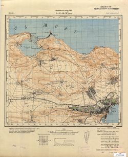
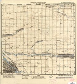
Search Constraints
You searched for:
State/Province
РСФСР (RSFSR)
Remove constraint State/Province: РСФСР (RSFSR)
Search Results
-
- Description:
- 1937
- Subject:
- Topical Subject: Soviet Union, Topical Subject: Maps, and Geographic Subject: Rudnya
- Publisher:
- Генеральный штаб РККА
- Language:
- Russian
- Identifier:
- VAC9619-000433
- Genre:
- Military Maps and Topographic Maps
- Geographic Location:
- Coordinates: 55.6667, 29.75, 55.8333, 30
- Related URL:
- Download GeoTIFF: https://drive.google.com/open?id=1pjBbMvMADu6X1fhFqKNsAViSBd9R1ZK8 and Catalog URL: http://iucat.iu.edu/catalog/5020131
- Abstract:
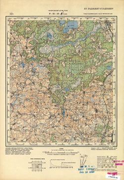
- Modern area represented: abandoned populated place Rudnya, Vitebskaya oblast, Belarus
- Call Number:
- G7000 s50 .S68 sheet N-35-12-D
- Caption:
- Не подлежит оглашению
- City:
- Рудня (Rudnya)
- Copyright Holder:
- No Copyright - United States
- Country:
- СССР (USSR)
- State/Province:
- РСФСР (RSFSR), Белорусская ССР (Byelorussian Soviet Socialist Republic), Витебская область (Vitebsk oblast), and Калининская область (Kalinin oblast)
- Physical Description:
- Scale: 1:50,000
- Persistent URL:
- http://purl.dlib.indiana.edu/iudl/images/VAC9619/VAC9619-000433
- Provenance:
- M. I. Map Library, G000-30
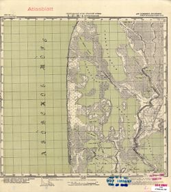
-
- Description:
- 1937
- Subject:
- Geographic Subject: Vypush, Topical Subject: Soviet Union, and Topical Subject: Maps
- Publisher:
- Генеральный штаб РККА
- Language:
- Russian
- Identifier:
- VAC9619-000432
- Genre:
- Topographic Maps and Military Maps
- Geographic Location:
- Coordinates: 55.6667, 29.5, 55.8333, 29.75
- Related URL:
- Catalog URL: http://iucat.iu.edu/catalog/5020131 and Download GeoTIFF: https://drive.google.com/open?id=1SLX1MIVRQSAGqoHdUivrMkMO70pMHy7r
- Abstract:
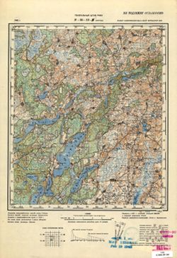
- Modern area represented: abandoned populated place Vypush, Vitebsk oblast, Belarus
- Call Number:
- G7000 s50 .S68 sheet N-35-12-C
- Caption:
- Не подлежит оглашению
- City:
- Выпуш (Vypush)
- Copyright Holder:
- No Copyright - United States
- Country:
- СССР (USSR)
- State/Province:
- Белорусская ССР (Byelorussian Soviet Socialist Republic), РСФСР (RSFSR), Витебская область (Vitebsk oblast), and Калининская область (Kalinin oblast)
- Physical Description:
- Scale: 1:50,000
- Persistent URL:
- http://purl.dlib.indiana.edu/iudl/images/VAC9619/VAC9619-000432
- Provenance:
- M. I. Map Library, Reichsamt für Landesaufnahme, Kartensammlung, GS, RA, G000-30
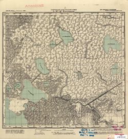
-
- Description:
- 1937
- Subject:
- Topical Subject: Maps, Geographic Subject: Jeziaryshcha, and Topical Subject: Soviet Union
- Publisher:
- Генеральный штаб РККА
- Language:
- Russian
- Identifier:
- VAC9619-000431
- Genre:
- Military Maps and Topographic Maps
- Geographic Location:
- Coordinates: 55.8333, 29.75, 56, 30
- Related URL:
- https://drive.google.com/file/d/1mPSwhWa001XEhS6idD5HYHATqrkblV9s/view?usp=sharing, Download GeoTIFF: https://drive.google.com/file/d/1cV_6oJpRF6DMO3fWnieBK2...
- Abstract:
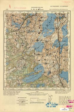
- Modern area represented: Jeziaryshcha, Vitebsk oblast, Belarus
- Call Number:
- G7000 s50 .S68 sheet N-35-12-B
- Caption:
- Не подлежит оглашению
- City:
- Езерище (Yezerishche)
- Copyright Holder:
- No Copyright - United States
- Country:
- СССР (USSR)
- State/Province:
- Витебская область (Vitebsk oblast), Белорусская ССР (Byelorussian Soviet Socialist Republic), Калининская область (Kalinin oblast), and РСФСР (RSFSR)
- Physical Description:
- Scale: 1:50,000
- Persistent URL:
- http://purl.dlib.indiana.edu/iudl/images/VAC9619/VAC9619-000431
- Provenance:
- M. I. Map Library, Heeresplankammer Gruppe Archive Auslandskartenarchiv, GS, RA, G000-30, Atlasblatt
-
- Description:
- 1927
- Subject:
- Geographic Subject: Teleshovo, Topical Subject: Maps, and Topical Subject: Soviet Union
- Publisher:
- Управление военных топографов
- Language:
- Russian
- Identifier:
- VAC9619-000430
- Genre:
- Topographic Maps and Military Maps
- Geographic Location:
- Coordinates: 55.8333, 29.75, 56.0, 30.0
- Related URL:
- Download GeoTIFF: https://drive.google.com/open?id=1rMUqxQMTSTl4Rlj1TMoJ9VJzjjFAkCQZ and Catalog URL: http://iucat.iu.edu/catalog/5020131
- Abstract:
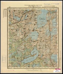
- Modern area represented: Teleshovo, Pskov oblast, Russia
- Call Number:
- G7000 s50 .S68 sheet N-35-12-B
- Caption:
- Не подлежит оглашению
- City:
- Телешово (Teleshovo)
- Copyright Holder:
- No Copyright - United States
- Country:
- СССР (USSR)
- State/Province:
- Западная область (Western oblast), Белорусская ССР (Byelorussian Soviet Socialist Republic), and РСФСР (RSFSR)
- Physical Description:
- Scale: 1:50,000
- Persistent URL:
- http://purl.dlib.indiana.edu/iudl/images/VAC9619/VAC9619-000430
- Provenance:
- CIA Map Branch -- Received
-
- Subject:
- Geographic Subject: Yermoshino, Topical Subject: Maps, and Topical Subject: Soviet Union
- Publisher:
- Управление военных топографов
- Language:
- Russian
- Identifier:
- VAC9619-000429
- Genre:
- Military Maps and Topographic Maps
- Geographic Location:
- Coordinates: 55.8333, 29.5, 56, 29.75
- Related URL:
- Catalog URL: http://iucat.iu.edu/catalog/5020131 and Download GeoTIFF: https://drive.google.com/open?id=1Ox5SYawhJ-nQv4JcxYkeYF4KQqVjNg_H
- Abstract:
- Modern area represented: Yermoshino, Pskov oblast, Russia
- Call Number:
- G7000 s50 .S68 sheet N-35-12-A
- Caption:
- Не подлежит оглашению
- City:
- Ермошино (Yermoshino)
- Copyright Holder:
- No Copyright - United States
- Country:
- СССР (USSR)
- State/Province:
- Западная область (Western oblast) and РСФСР (RSFSR)
- Physical Description:
- Scale: 1:50,000
- Persistent URL:
- http://purl.dlib.indiana.edu/iudl/images/VAC9619/VAC9619-000429
- Provenance:
- M. I. Map Library, G000-30, GS, RA
-
- Subject:
- Geographic Subject: Krasnapolle, Topical Subject: Soviet Union, and Topical Subject: Maps
- Publisher:
- Генеральный штаб РККА
- Language:
- Russian
- Identifier:
- VAC9619-000428
- Genre:
- Topographic Maps and Military Maps
- Geographic Location:
- Coordinates: 55.6667, 29.25, 55.8333, 29.5
- Related URL:
- Catalog URL: http://iucat.iu.edu/catalog/5020131 and Download GeoTIFF: https://drive.google.com/open?id=1lnFFPfIgSAAmfNYy3K1v2DcWEbI3vPvP
- Abstract:
- Modern area represented: Krasnapolle, Vitebsk oblast, Belarus
- Call Number:
- G7000 s50 .S68 sheet N-35-11-D
- Caption:
- Не подлежит оглашению
- City:
- Краснополье (Krasnopolye)
- Copyright Holder:
- No Copyright - United States
- Country:
- СССР (USSR)
- State/Province:
- РСФСР (RSFSR), Калининская область (Kalinin oblast), Витебская область (Vitebsk oblast), and Белорусская ССР (Byelorussian Soviet Socialist Republic)
- Physical Description:
- Scale: 1:50,000
- Persistent URL:
- http://purl.dlib.indiana.edu/iudl/images/VAC9619/VAC9619-000428
- Provenance:
- M. I. Map Library, G000-30, GS, RA
-
- Subject:
- Geographic Subject: Krashuty, Topical Subject: Maps, and Topical Subject: Soviet Union
- Publisher:
- Управление военных топографов
- Language:
- Russian
- Identifier:
- VAC9619-000426
- Genre:
- Topographic Maps and Military Maps
- Geographic Location:
- Coordinates: 55.8333, 29.25, 56, 29.5
- Related URL:
- Catalog URL: http://iucat.iu.edu/catalog/5020131 and Download GeoTIFF: https://drive.google.com/open?id=1tf9RB0iuVFHq_Psx2Ej0269uQJfaccpo
- Abstract:
- Modern area represented: Krashuty, Vitebsk oblast, Belarus
- Call Number:
- G7000 s50 .S68 sheet N-35-11-B
- Caption:
- Не подлежит оглашению
- City:
- Крашуты (Krashuty)
- Copyright Holder:
- No Copyright - United States
- Country:
- СССР (USSR)
- State/Province:
- РСФСР (RSFSR), Белорусская ССР (Byelorussian Soviet Socialist Republic), and Западная область (Western oblast)
- Physical Description:
- Scale: 1:50,000
- Persistent URL:
- http://purl.dlib.indiana.edu/iudl/images/VAC9619/VAC9619-000426
- Provenance:
- CIA Map Branch -- Received
-
- Description:
- 1937
- Subject:
- Topical Subject: Maps, Geographic Subject: Dvoryshcha, and Topical Subject: Soviet Union
- Publisher:
- Генеральный штаб РККА
- Language:
- Russian
- Identifier:
- VAC9619-000425
- Genre:
- Military Maps and Topographic Maps
- Geographic Location:
- Coordinates: 55.8333, 29, 56, 29.25
- Related URL:
- Catalog URL: http://iucat.iu.edu/catalog/5020131 and Download GeoTIFF: https://drive.google.com/open?id=12CH1ONXEHMp_Dt341id95ZiovrdQ3IWa
- Abstract:
- Modern area represented: Dvoryshcha, Vitebsk oblast, Belarus
- Call Number:
- G7000 s50 .S68 sheet N-35-11-A
- Caption:
- Не подлежит оглашению
- City:
- Дворище (Dvorishche)
- Copyright Holder:
- No Copyright - United States
- Country:
- СССР (USSR)
- State/Province:
- Белорусская ССР (Byelorussian Soviet Socialist Republic), Калининская область (Kalinin oblast), Витебская область (Vitebsk oblast), and РСФСР (RSFSR)
- Physical Description:
- Scale: 1:50,000
- Persistent URL:
- http://purl.dlib.indiana.edu/iudl/images/VAC9619/VAC9619-000425
- Provenance:
- M. I. Map Library, G000-30
-
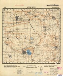
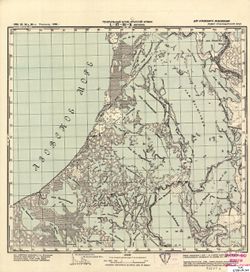
- Description:
- 1937
- Subject:
- Geographic Subject: Rasony, Topical Subject: Soviet Union, and Topical Subject: Maps
- Publisher:
- Генеральный штаб РККА
- Language:
- Russian
- Identifier:
- VAC9619-000421
- Genre:
- Topographic Maps and Military Maps
- Geographic Location:
- Coordinates: 55.833, 28.75, 56, 29
- Related URL:
- Catalog URL: http://iucat.iu.edu/catalog/5020131 and Download GeoTIFF: https://drive.google.com/open?id=1UDh7PVaAfA36BDI3q9RzDpHQrc2og3Oe
- Abstract:
- Modern area represented: Rasony, Vitebsk oblast, Belarus
- Call Number:
- G7000 s50 .S68 sheet N-35-10-B
- Caption:
- Не подлежит оглашению
- City:
- Станиславово (Stanislavovo)
- Copyright Holder:
- No Copyright - United States
- Country:
- СССР (USSR)
- State/Province:
- Калининская область (Kalinin oblast), Белорусская ССР (Byelorussian Soviet Socialist Republic), РСФСР (RSFSR), and Витебская область (Vitebsk oblast)
- Physical Description:
- Scale: 1:50,000
- Persistent URL:
- http://purl.dlib.indiana.edu/iudl/images/VAC9619/VAC9619-000421
- Provenance:
- Army Map Service Library, OMAHA, Library of Congress Geography & Map Division
-
- Description:
- 1937
- Subject:
- Geographic Subject: Klyastsitsy, Topical Subject: Maps, and Topical Subject: Soviet Union
- Publisher:
- Генеральный штаб РККА
- Language:
- Russian
- Identifier:
- VAC9619-000420
- Genre:
- Topographic Maps and Military Maps
- Geographic Location:
- Coordinates: 55.833, 28.5, 56, 28.75
- Related URL:
- Catalog URL: http://iucat.iu.edu/catalog/5020131 and Download GeoTIFF: https://drive.google.com/open?id=1qG_7FsG2f_slk9_mkoQw5bIMHLDQJb4o
- Abstract:
- Modern area represented: Klyastsitsy, Vitebsk oblast, Belarus
- Call Number:
- G7000 s50 .S68 sheet N-35-10-A
- Caption:
- Не подлежит оглашению
- City:
- Клястицы (Kliastitsy)
- Copyright Holder:
- No Copyright - United States
- Country:
- СССР (USSR)
- State/Province:
- РСФСР (RSFSR), Витебская область (Vitebsk oblast), Калининская область (Kalinin oblast), and Белорусская ССР (Byelorussian Soviet Socialist Republic)
- Physical Description:
- Scale: 1:50,000
- Persistent URL:
- http://purl.dlib.indiana.edu/iudl/images/VAC9619/VAC9619-000420
- Provenance:
- DMA Topographic Center, Army Map Service Library, OMAHA
-
- Description:
- 1931
- Subject:
- Topical Subject: Maps, Geographic Subject: Mingrelskaya, and Topical Subject: Soviet Union
- Publisher:
- Управление военных топографов РККА
- Language:
- Russian
- Date Created:
- 1935
- Identifier:
- VAC9619-000137
- Genre:
- Military Maps and Topographic Maps
- Geographic Location:
- Coordinates: 45, 38.25, 45.167, 38.5
- Related URL:
- Catalog URL: http://iucat.iu.edu/catalog/5020131 and Download GeoTIFF: https://drive.google.com/open?id=1bLzhcgUh8GhgTJT4RxBKFm6tUA0f-6nQ
- Abstract:
- Modern area represented: Mingrelskaya, Krasnodarskiy kray, Russia
- Call Number:
- G7000 s50 .S68 and zsheet L-37-101-D
- Caption:
- Не подлежит оглашению
- City:
- Мингрельская (Mingrelskaya)
- Copyright Holder:
- No Copyright - United States
- Country:
- СССР (USSR)
- State/Province:
- Азово-Черноморский край (Azov-Black Sea kray) and РСФСР (RSFSR)
- Physical Description:
- Scale: 1:50,000
- Persistent URL:
- http://purl.dlib.indiana.edu/iudl/images/VAC9619/VAC9619-000137
- Provenance:
- DMA Topographic Center, Army Map Service Library, OMAHA, Library of Congress Geography & Map Division
-
- Subject:
- Topical Subject: Maps, Topical Subject: Soviet Union, and Geographic Subject: Ivanovskaya
- Publisher:
- Генеральный штаб Красной Армии
- Language:
- Russian
- Date Created:
- 1941
- Identifier:
- VAC9619-000136
- Genre:
- Topographic Maps and Military Maps
- Geographic Location:
- Coordinates: 45.1667, 38.25, 45.3333, 38.5
- Related URL:
- Download GeoTIFF: https://drive.google.com/open?id=1PT7DJWKnoX18bFhDVpk--LmrcJbl114Z and Catalog URL: http://iucat.iu.edu/catalog/5020131
- Abstract:
- Modern area represented: Ivanovskaya, Krasnodar kray, Russia
- Call Number:
- G7000 s50 .S68 sheet L-37-101-B
- Caption:
- Для служебного пользования
- City:
- Ивановская (Ivanovskaya)
- Copyright Holder:
- No Copyright - United States
- Country:
- СССР (USSR)
- State/Province:
- РСФСР (RSFSR) and Краснодарский край (Krasnodar kray)
- Physical Description:
- Scale: 1:50,000
- Persistent URL:
- http://purl.dlib.indiana.edu/iudl/images/VAC9619/VAC9619-000136
- Provenance:
- DMA Topographic Center, Army Map Service Library, Library of Congress Geography & Map Division
-
- Subject:
- Topical Subject: Maps, Topical Subject: Soviet Union, and Geographic Subject: Marivka
- Publisher:
- Генеральный штаб РККА
- Language:
- Russian
- Identifier:
- VAC9619-000135
- Genre:
- Military Maps and Topographic Maps
- Geographic Location:
- Coordinates: 45, 36, 45.1667, 36.25
- Related URL:
- Catalog URL: http://iucat.iu.edu/catalog/5020131 and Download GeoTIFF: https://drive.google.com/open?id=1PT8SdyXHcahebOwNRwqtocvV-yNJmkwb
- Abstract:
- Modern area represented: Marivka, Republic of Crimea, Ukraine
- Call Number:
- G7000 s50 .S68 sheet L-37-97-C
- Caption:
- Не подлежит оглашению
- City:
- Марьевка (Maryevka)
- Copyright Holder:
- No Copyright - United States
- Country:
- СССР (USSR)
- State/Province:
- РСФСР (RSFSR) and Крымская АССР (Crimean Autonomous Soviet Socialist Republic)
- Physical Description:
- Scale: 1:50,000
- Persistent URL:
- http://purl.dlib.indiana.edu/iudl/images/VAC9619/VAC9619-000135
- Provenance:
- CIA Map Branch -- Received, G000-30
-
- Description:
- 1934
- Subject:
- Geographic Subject: Marfivka, Topical Subject: Soviet Union, and Topical Subject: Maps
- Publisher:
- Генеральный штаб РККА
- Language:
- Russian
- Identifier:
- VAC9619-000134
- Genre:
- Topographic Maps and Military Maps
- Geographic Location:
- Coordinates: 45.1667, 36, 45.3333, 36.25
- Related URL:
- Catalog URL: http://iucat.iu.edu/catalog/5020131 and Download GeoTIFF: https://drive.google.com/open?id=12-jWRYlkV_GfGwMFQZ4AYYJQ72csY2N1
- Abstract:
- Modern area represented: Marfivka, Republic of Crimea, Ukraine
- Call Number:
- G7000 s50 .S68 sheet L-37-97-A
- Caption:
- Не подлежит оглашению,Секретно
- City:
- Марфовка (Marfovka)
- Copyright Holder:
- No Copyright - United States
- Country:
- СССР (USSR)
- State/Province:
- Крымская АССР (Crimean Autonomous Soviet Socialist Republic) and РСФСР (RSFSR)
- Physical Description:
- Scale: 1:50,000
- Persistent URL:
- http://purl.dlib.indiana.edu/iudl/images/VAC9619/VAC9619-000134
- Provenance:
- M. I. Map Library, CIA Map Library, Atlasblatt, G000-30
-
- Subject:
- Topical Subject: Maps, Topical Subject: Soviet Union, and Geographic Subject: Poltavskaya
- Publisher:
- Генеральный штаб Красной Армии
- Language:
- Russian
- Date Created:
- 1941
- Identifier:
- VAC9619-000133
- Genre:
- Topographic Maps and Military Maps
- Geographic Location:
- Coordinates: 45.3333, 38, 45.5, 38.25
- Related URL:
- Download GeoTIFF: https://drive.google.com/open?id=1_yhmVD-n1GRbBfy2AXtxeuRz0-z2YVXw and Catalog URL: http://iucat.iu.edu/catalog/5020131
- Abstract:
- Modern area represented: Poltavskaya, Krasnodar kray, Russia
- Call Number:
- G7000 s50 .S68 sheet L-37-89-C
- Caption:
- Для служебного пользования
- City:
- Красноармейская (Krasnoarmeyskaya)
- Copyright Holder:
- No Copyright - United States
- Country:
- СССР (USSR)
- State/Province:
- Краснодарский край (Krasnodar kray) and РСФСР (RSFSR)
- Physical Description:
- Scale: 1:50,000
- Persistent URL:
- http://purl.dlib.indiana.edu/iudl/images/VAC9619/VAC9619-000133
- Provenance:
- CIA Map Library, Atlasblatt
-
- Subject:
- Topical Subject: Soviet Union, Geographic Subject: Petrovskaya, and Topical Subject: Maps
- Publisher:
- Генеральный штаб Красной Армии
- Language:
- Russian
- Date Created:
- 1941
- Identifier:
- VAC9619-000132
- Genre:
- Military Maps and Topographic Maps
- Geographic Location:
- Coordinates: 45.25, 37.75, 45.5, 38
- Related URL:
- Download GeoTIFF: https://drive.google.com/open?id=1b9vXAMVyirDWaVse-DMZ1scjXI3etyxs and Catalog URL: http://iucat.iu.edu/catalog/5020131
- Abstract:
- Modern area represented: Petrovskaya, Krasnodar kray, Russia
- Call Number:
- G7000 s50 .S68 sheet L-37-88-D
- Caption:
- Для служебного пользования
- City:
- Петровская (Petrovskaya)
- Copyright Holder:
- No Copyright - United States
- Country:
- СССР (USSR)
- State/Province:
- Краснодарский край (Krasnodar kray) and РСФСР (RSFSR)
- Physical Description:
- Scale: 1:50,000
- Persistent URL:
- http://purl.dlib.indiana.edu/iudl/images/VAC9619/VAC9619-000132
- Provenance:
- CIA Map Branch -- Received, G000-30
-
- Subject:
- Topical Subject: Soviet Union, Topical Subject: Maps, and Geographic Subject: Verkhniy
- Publisher:
- Генеральный штаб Красной Армии
- Language:
- Russian
- Identifier:
- VAC9619-000131
- Genre:
- Topographic Maps and Military Maps
- Geographic Location:
- Coordinates: 45.3333, 37.5, 45.5, 37.75
- Related URL:
- Download GeoTIFF: https://drive.google.com/open?id=1SmvRqOgL6Qn7FI89jOzJ5lYgG0QO0Enc and Catalog URL: http://iucat.iu.edu/catalog/5020131
- Abstract:
- Modern area represented: Verkhniy, Krasnodar kray, Russia
- Call Number:
- G7000 s50 .S68 sheet L-37-88-C
- Caption:
- Для служебного пользования
- City:
- Верхние (Verkhniye)
- Copyright Holder:
- No Copyright - United States
- Country:
- СССР (USSR)
- State/Province:
- РСФСР (RSFSR) and Краснодарский край (Krasnodar kray)
- Physical Description:
- Scale: 1:50,000
- Persistent URL:
- http://purl.dlib.indiana.edu/iudl/images/VAC9619/VAC9619-000131
- Provenance:
- CIA Map Branch -- Received, G000-30
-
- Subject:
- Geographic Subject: Mostovyanskiy, Topical Subject: Maps, and Topical Subject: Soviet Union
- Publisher:
- Генеральный штаб Красной Армии
- Language:
- Russian
- Identifier:
- VAC9619-000130
- Genre:
- Topographic Maps and Military Maps
- Geographic Location:
- Coordinates: 45.5, 37.75, 45.6667, 38
- Related URL:
- Download GeoTIFF: https://drive.google.com/open?id=1FxgopBJDFUxCW9M2khgArOVMc-r61voV and Catalog URL: http://iucat.iu.edu/catalog/5020131
- Abstract:
- Modern area represented: Mostovyanskiy, Krasnodar kray, Russia
- Call Number:
- G7000 s50 .S68 sheet L-37-88-B
- Caption:
- Для служебного пользования
- City:
- Мостовянский (Mostovyanskiy)
- Copyright Holder:
- No Copyright - United States
- Country:
- СССР (USSR)
- State/Province:
- Краснодарский край (Krasnodar kray) and РСФСР (RSFSR)
- Physical Description:
- Scale: 1:50,000
- Persistent URL:
- http://purl.dlib.indiana.edu/iudl/images/VAC9619/VAC9619-000130
- Provenance:
- M. I. Map Library, G000-30, Atlasblatt
-
- Subject:
- Topical Subject: Soviet Union, Topical Subject: Maps, and Geographic Subject: Chernoyerkovskaya
- Publisher:
- Генеральный штаб Красной Армии
- Language:
- Russian
- Date Created:
- 1941
- Identifier:
- VAC9619-000129
- Genre:
- Topographic Maps and Military Maps
- Geographic Location:
- Coordinates: 45.5, 37.5, 45.6667, 37.75
- Related URL:
- Download GeoTIFF: https://drive.google.com/open?id=1MUz-JDusllMZw5oBsLVrZJSCmB7fkXOy and Catalog URL: http://iucat.iu.edu/catalog/5020131
- Abstract:
- Modern area represented: Chernoyerkovskaya, Krasnodar kray, Russia
- Call Number:
- G7000 s50 .S68 sheet L-37-88-A
- Caption:
- Для служебного пользования
- City:
- Черноерковский (Chernoyerkovskiy)
- Copyright Holder:
- No Copyright - United States
- Country:
- СССР (USSR)
- State/Province:
- Краснодарский край (Krasnodar kray) and РСФСР (RSFSR)
- Physical Description:
- Scale: 1:50,000
- Persistent URL:
- http://purl.dlib.indiana.edu/iudl/images/VAC9619/VAC9619-000129
- Provenance:
- M. I. Map Library, G000-30, Atlasblatt
-
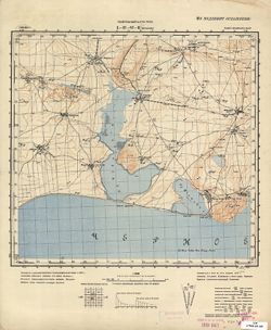
- Subject:
- Geographic Subject: Kerch, Topical Subject: Soviet Union, and Topical Subject: Maps
- Publisher:
- Генеральный штаб РККА
- Language:
- Russian
- Identifier:
- VAC9619-000128
- Genre:
- Topographic Maps and Military Maps
- Geographic Location:
- Coordinates: 45.3333, 36.25, 45.5, 36.5
- Related URL:
- Catalog URL: http://iucat.iu.edu/catalog/5020131 and Download GeoTIFF: https://drive.google.com/open?id=15cRbHG-lCDaYB9J9sBpb9MtHXrUWbGdU
- Abstract:
- Modern area represented: Kerch, Republic of Crimea, Ukraine
- Call Number:
- G7000 s50 .S68 sheet L-37-85-D
- Caption:
- Не подлежит оглашению,Секретно
- City:
- Керчь (Kerch)
- Copyright Holder:
- No Copyright - United States
- Country:
- СССР (USSR)
- State/Province:
- Крымская АССР (Crimean Autonomous Soviet Socialist Republic) and РСФСР (RSFSR)
- Physical Description:
- Scale: 1:50,000
- Persistent URL:
- http://purl.dlib.indiana.edu/iudl/images/VAC9619/VAC9619-000128
- Provenance:
- CIA Map Branch -- Received, G000-30
-
- Subject:
- Topical Subject: Soviet Union, Geographic Subject: Byeglitskaya Spit, and Topical Subject: Maps
- Publisher:
- Генеральный штаб Красной Армии
- Language:
- Russian
- Identifier:
- VAC9619-000126
- Genre:
- Topographic Maps and Military Maps
- Geographic Location:
- Coordinates: 47, 38.5, 47.1667, 38.75
- Related URL:
- Catalog URL: http://iucat.iu.edu/catalog/5020131 and Download GeoTIFF: https://drive.google.com/open?id=1v122mO_SmKQSM5zBex63FJBogjJZ8VRs
- Abstract:
- Modern area represented: Byeglitskaya Spit, Rostov oblast, Russia
- Call Number:
- G7000 s50 .S68 sheet L-37-30-B
- Caption:
- Для служебного пользования
- City:
- Хутора Беглицкая Коса (Khutora Byeglitskaya Kosa)
- Copyright Holder:
- No Copyright - United States
- Country:
- СССР (USSR)
- State/Province:
- РСФСР (RSFSR) and Ростовская область (Rostov oblast)
- Physical Description:
- Scale: 1:50,000
- Persistent URL:
- http://purl.dlib.indiana.edu/iudl/images/VAC9619/VAC9619-000126
- Provenance:
- DMA Topographic Center, Army Map Service Library, Library of Congress Geography & Map Division
-
- Description:
- 1940
- Subject:
- Geographic Subject: Arkhangelskaya, Topical Subject: Soviet Union, and Topical Subject: Maps
- Publisher:
- Генеральный штаб Красной Армии
- Language:
- Russian
- Date Created:
- 1942
- Identifier:
- VAC9619-000127
- Genre:
- Military Maps and Topographic Maps
- Geographic Location:
- Coordinates: 45.667, 40.25, 45.833, 40.5
- Related URL:
- Catalog URL: http://iucat.iu.edu/catalog/5020131 and Download GeoTIFF: https://drive.google.com/open?id=1GDZbtF58j6b2uyCwLieywbjdUdobJxb3
- Abstract:
- Modern area represented: Arkhangelskaya, Krasnodar kray, Russia
- Call Number:
- G7000 s50 .S68 sheet L-37-81-D
- Caption:
- Для служебного пользования
- City:
- Архангельская (Arkhangel'skaya)
- Copyright Holder:
- No Copyright - United States
- Country:
- СССР (USSR)
- State/Province:
- РСФСР (RSFSR) and Краснодарский край (Krasnodar kray)
- Physical Description:
- Scale: 1:50,000
- Persistent URL:
- http://purl.dlib.indiana.edu/iudl/images/VAC9619/VAC9619-000127
- Provenance:
- CIA Map Branch -- Received, G000-30
-
- Description:
- 1940
- Subject:
- Topical Subject: Maps, Topical Subject: Soviet Union, and Geographic Subject: Peredmistne
- Publisher:
- Генеральный штаб Красной Армии
- Language:
- Russian
- Date Created:
- 1942
- Identifier:
- VAC9619-000123
- Genre:
- Topographic Maps and Military Maps
- Geographic Location:
- Coordinates: 45.8333, 34.5, 46, 34.75
- Related URL:
- https://drive.google.com/open?id=10x2abEgI_sYvWJWaepRIpxG5c1jbwXZ_, Catalog URL: http://iucat.iu.edu/catalog/5020131, and Download GeoTIFF: https://drive.goo...
- Abstract:
- Modern area represented: Peredmistne, Republic of Crimea, Ukraine
- Call Number:
- G7000 s50 .S68 sheet L-36-82-A
- Caption:
- Для служебного пользования
- City:
- Тюп-Джанкой (Tyup-Dzhankoy)
- Copyright Holder:
- No Copyright - United States
- Country:
- СССР (USSR)
- State/Province:
- Запорожская область (Zaporizhia oblast), Украинская ССР (Ukrainian Soviet Socialist Republic), Крымская АССР (Crimean Autonomous Soviet Socialist Republic), ...
- Physical Description:
- Scale: 1:50,000
- Persistent URL:
- http://purl.dlib.indiana.edu/iudl/images/VAC9619/VAC9619-000123
- Provenance:
- DMA Topographic Center, Army Map Service Library, OMAHA, Library of Congress Geography & Map Division
-
- Description:
- 1933
- Subject:
- Geographic Subject: Pulcheyla, Topical Subject: Soviet Union, and Topical Subject: Maps
- Language:
- Russian
- Date Created:
- 1933
- Identifier:
- VAC9619-000069
- Genre:
- Military Maps and Topographic Maps
- Geographic Location:
- Coordinates: 61.333, 32.137, 61.5, 32.5
- Related URL:
- Catalog URL: http://iucat.iu.edu/catalog/5020131 and Download GeoTIFF: https://drive.google.com/open?id=1sntEOE0udkFPFBOTe018EIPqgTx8xKkm
- Abstract:
- Modern area represented: Pulcheyla, Republic of Karelia, Russia
- Call Number:
- G7000 s50 .S68 sheet P-36-89-C
- City:
- Пульчейло (Pulcheylo)
- Copyright Holder:
- No Copyright - United States
- Country:
- СССР (USSR)
- State/Province:
- Карельская АССР (Karelian Autonomous Soviet Socialist Republic) and РСФСР (RSFSR)
- Physical Description:
- Scale: 1:50,000
- Persistent URL:
- http://purl.dlib.indiana.edu/iudl/images/VAC9619/VAC9619-000069
- Provenance:
- DMA Topographic Center, Army Map Service Library, OMAHA, Library of Congress Geography & Map Division
-
- Description:
- 1934
- Subject:
- Topical Subject: Soviet Union, Topical Subject: Maps, and Geographic Subject: Gilkozha
- Language:
- Russian
- Identifier:
- VAC9619-000067
- Genre:
- Topographic Maps and Military Maps
- Geographic Location:
- Coordinates: 61.5, 32, 61.667, 32.25
- Related URL:
- Download GeoTIFF: https://drive.google.com/open?id=1LMufJbthe1GpqewHgRmjdB4VosK-WtJK and Catalog URL: http://iucat.iu.edu/catalog/5020131
- Abstract:
- Modern area represented: Gilkozha, Republic of Karelia, Russia
- Call Number:
- G7000 s50 .S68 sheet P-36-89-A
- City:
- Ювенсу (Yuvensu)
- Copyright Holder:
- No Copyright - United States
- Country:
- СССР (USSR)
- State/Province:
- РСФСР (RSFSR) and Карельская АССР (Karelian Autonomous Soviet Socialist Republic)
- Physical Description:
- Scale: 1:50,000
- Persistent URL:
- http://purl.dlib.indiana.edu/iudl/images/VAC9619/VAC9619-000067
- Provenance:
- M. I. Map Library, G000-30, GS, RA, Atlasblatt
-
- Subject:
- Topical Subject: Maps, Geographic Subject: Pazhilo, and Topical Subject: Soviet Union
- Language:
- Russian
- Identifier:
- VAC9619-000066
- Genre:
- Topographic Maps and Military Maps
- Geographic Location:
- Coordinates: 61.667, 32.25, 61.833, 32.5
- Related URL:
- Download GeoTIFF: https://drive.google.com/open?id=11OfMCa_E44TFwpGOdRsRl1d9twyoNcZQ and Catalog URL: http://iucat.iu.edu/catalog/5020131
- Abstract:
- Modern area represented: Pazhilo, Republic of Karelia, Russia
- Call Number:
- G7000 s50 .S68 sheet P-36-77-G
- City:
- Пажило (Pazhilo)
- Copyright Holder:
- No Copyright - United States
- Country:
- СССР (USSR)
- State/Province:
- Карельская АССР (Karelian Autonomous Soviet Socialist Republic) and РСФСР (RSFSR)
- Physical Description:
- Scale: 1:50,000
- Persistent URL:
- http://purl.dlib.indiana.edu/iudl/images/VAC9619/VAC9619-000066
- Provenance:
- DMA Topographic Center, Army Map Service Library, Library of Congress Geography & Map Division
-
- Description:
- 1934
- Subject:
- Topical Subject: Soviet Union, Geographic Subject: Kolatselga, and Topical Subject: Maps
- Language:
- Russian
- Identifier:
- VAC9619-000065
- Genre:
- Topographic Maps and Military Maps
- Geographic Location:
- Coordinates: 61.667, 32, 61.833, 32.25
- Related URL:
- Catalog URL: http://iucat.iu.edu/catalog/5020131 and Download GeoTIFF: https://drive.google.com/open?id=1JH8SGoiabG5jitcDvA-ayFvLzptmn4nb
- Abstract:
- Modern area represented: Kolatselga, Republic of Karelia, Russia
- Call Number:
- G7000 s50 .S68 sheet P-36-77-B
- City:
- Колат-Сельга (Kolat-Selga)
- Copyright Holder:
- No Copyright - United States
- Country:
- СССР (USSR)
- State/Province:
- Карельская АССР (Karelian Autonomous Soviet Socialist Republic) and РСФСР (RSFSR)
- Physical Description:
- Scale: 1:50,000
- Persistent URL:
- http://purl.dlib.indiana.edu/iudl/images/VAC9619/VAC9619-000065
- Provenance:
- DMA Topographic Center, Army Map Service Library, OMAHA, Library of Congress Geography & Map Division
-
- Description:
- 1934
- Subject:
- Topical Subject: Soviet Union, Topical Subject: Maps, and Geographic Subject: Nishkozero
- Language:
- Russian
- Identifier:
- VAC9619-000064
- Genre:
- Military Maps and Topographic Maps
- Geographic Location:
- Coordinates: 61.833, 32.128, 62, 32.5
- Related URL:
- Catalog URL: http://iucat.iu.edu/catalog/5020131 and Download GeoTIFF: https://drive.google.com/open?id=1jFcONOAbCc57tOkEsGOvp2cxlZFHhi7R
- Abstract:
- Modern area represented: Nishkozero, Republic of Karelia, Russia
- Call Number:
- G7000 s50 .S68 sheet P-36-77-A
- City:
- Нишкозеро (Nishkozero)
- Copyright Holder:
- No Copyright - United States
- Country:
- СССР (USSR)
- State/Province:
- Карельская АССР (Karelian Autonomous Soviet Socialist Republic) and РСФСР (RSFSR)
- Physical Description:
- Scale: 1:50,000
- Persistent URL:
- http://purl.dlib.indiana.edu/iudl/images/VAC9619/VAC9619-000064
- Provenance:
- DMA Topographic Center, Army Map Service Library, Library of Congress Geography & Map Division
-
- Description:
- 1932
- Subject:
- Topical Subject: Maps, Topical Subject: Soviet Union, and Geographic Subject: Poddorye
- Publisher:
- Управление военных топографов
- Language:
- Russian
- Identifier:
- VAC9619-000059
- Genre:
- Military Maps and Topographic Maps
- Geographic Location:
- Coordinates: 57.3333, 31, 57.5, 31.25
- Related URL:
- Download GeoTIFF: https://drive.google.com/open?id=1KHLiD5Xcgw1Jy9IHEhkvrZ8x0LisRu2N and Catalog URL: http://iucat.iu.edu/catalog/5020131
- Abstract:
- Modern area represented: Poddorye, Novgorod oblast, Russia
- Call Number:
- G7000 s50 .S68 sheet O-36-87-C
- Caption:
- Не подлежит оглашению
- City:
- Поддорье (Poddorye)
- Copyright Holder:
- No Copyright - United States
- Country:
- СССР (USSR)
- State/Province:
- РСФСР (RSFSR) and Ленинградская область (Leningrad oblast)
- Physical Description:
- Scale: 1:50,000
- Persistent URL:
- http://purl.dlib.indiana.edu/iudl/images/VAC9619/VAC9619-000059
- Provenance:
- DMA Topographic Center, Army Map Service Library, OMAHA, Library of Congress Geography & Map Division
-
- Description:
- 1932
- Subject:
- Topical Subject: Soviet Union, Topical Subject: Maps, and Geographic Subject: Rakhlitsy
- Publisher:
- Управление военных топографов
- Language:
- Russian
- Identifier:
- VAC9619-000058
- Genre:
- Military Maps and Topographic Maps
- Geographic Location:
- Coordinates: 57.5, 31.25, 57.6667, 31.5
- Related URL:
- Catalog URL: http://iucat.iu.edu/catalog/5020131 and Download GeoTIFF: https://drive.google.com/open?id=1gFvH37OvUPB8JJNlVW7oqBMW0RBOgpl8
- Abstract:
- Modern area represented: Rakhlitsy, Novgorod oblast, Russia
- Call Number:
- G7000 s50 .S68 sheet O-36-87-B
- Caption:
- Не подлежит оглашению
- City:
- Рахлицы (Rakhlitsy)
- Copyright Holder:
- No Copyright - United States
- Country:
- СССР (USSR)
- State/Province:
- Ленинградская область (Leningrad oblast) and РСФСР (RSFSR)
- Physical Description:
- Scale: 1:50,000
- Persistent URL:
- http://purl.dlib.indiana.edu/iudl/images/VAC9619/VAC9619-000058
- Provenance:
- DMA Topographic Center, Army Map Service Library, OMAHA, Library of Congress Geography & Map Division
-
- Description:
- 1932
- Subject:
- Geographic Subject: Goyki, Topical Subject: Soviet Union, and Topical Subject: Maps
- Publisher:
- Управление военных топографов
- Language:
- Russian
- Identifier:
- VAC9619-000057
- Genre:
- Military Maps and Topographic Maps
- Geographic Location:
- Coordinates: 57.3333, 30.75, 57.5, 31
- Related URL:
- Download GeoTIFF: https://drive.google.com/open?id=1uPHbwDpz3QA4iUnsVAiM-DSIPN3bmQAN and Catalog URL: http://iucat.iu.edu/catalog/5020131
- Abstract:
- Modern area represented: Goyki, Novgorod oblast, Russia
- Call Number:
- G7000 s50 .S68 sheet O-36-86-D
- Caption:
- Не подлежит оглашению
- City:
- Гойки (Goyki)
- Copyright Holder:
- No Copyright - United States
- Country:
- СССР (USSR)
- State/Province:
- РСФСР (RSFSR) and Ленинградская область (Leningrad oblast)
- Physical Description:
- Scale: 1:50,000
- Persistent URL:
- http://purl.dlib.indiana.edu/iudl/images/VAC9619/VAC9619-000057
- Provenance:
- Army Map Service Library, OMAHA, Library of Congress Geography & Map Division
-
- Description:
- 1932
- Subject:
- Topical Subject: Soviet Union, Topical Subject: Maps, and Geographic Subject: Zapolye
- Publisher:
- Управление военных топографов
- Language:
- Russian
- Identifier:
- VAC9619-000056
- Genre:
- Topographic Maps and Military Maps
- Geographic Location:
- Coordinates: 57.3333, 30.5, 57.5, 30.75
- Related URL:
- Download GeoTIFF: https://drive.google.com/open?id=17_x28_Z_BDVfOkrBbY4QTkM7htZCIsu8 and Catalog URL: http://iucat.iu.edu/catalog/5020131
- Abstract:
- Modern area represented: Zapolye, Novgorod oblast, Russia
- Call Number:
- G7000 s50 .S68 sheet O-36-86-C
- Caption:
- Не подлежит оглашению
- City:
- Заполье (Zapolye)
- Copyright Holder:
- No Copyright - United States
- Country:
- СССР (USSR)
- State/Province:
- Ленинградская область (Leningrad oblast) and РСФСР (RSFSR)
- Physical Description:
- Scale: 1:50,000
- Persistent URL:
- http://purl.dlib.indiana.edu/iudl/images/VAC9619/VAC9619-000056
- Provenance:
- DMA Topographic Center, Army Map Service Library, OMAHA, Library of Congress Geography & Map Division
-
- Description:
- 1932
- Subject:
- Geographic Subject: Belebelka, Topical Subject: Maps, and Topical Subject: Soviet Union
- Publisher:
- Управление военных топографов
- Language:
- Russian
- Identifier:
- VAC9619-000055
- Genre:
- Topographic Maps and Military Maps
- Geographic Location:
- Coordinates: 57.5, 30.75, 57.6667, 31
- Related URL:
- Catalog URL: http://iucat.iu.edu/catalog/5020131 and Download GeoTIFF: https://drive.google.com/open?id=1C6Cj-kxR2Y0hfswiLv4YWUg4X6cHeUB1
- Abstract:
- Modern area represented: Belebelka, Novgorod oblast, Russia
- Call Number:
- G7000 s50 .S68 sheet O-36-86-B
- Caption:
- Не подлежит оглашению,Captured map
- City:
- Белебелка (Belebelka)
- Copyright Holder:
- No Copyright - United States
- Country:
- СССР (USSR)
- State/Province:
- РСФСР (RSFSR) and Ленинградская область (Leningrad oblast)
- Physical Description:
- Scale: 1:50,000
- Persistent URL:
- http://purl.dlib.indiana.edu/iudl/images/VAC9619/VAC9619-000055
- Provenance:
- DMA Topographic Center, Army Map Service Library, OMAHA, Library of Congress Geography & Map Division
-
- Description:
- 1932
- Subject:
- Geographic Subject: Verekhnovo, Topical Subject: Maps, and Topical Subject: Soviet Union
- Publisher:
- Управление военных топографов
- Language:
- Russian
- Identifier:
- VAC9619-000054
- Genre:
- Topographic Maps and Military Maps
- Geographic Location:
- Coordinates: 57.6667, 30.75, 57.8333, 31
- Related URL:
- Download GeoTIFF: https://drive.google.com/open?id=1w0q91rHaSgIKnspCuf5kMtcGTY9A-zZo and Catalog URL: http://iucat.iu.edu/catalog/5020131
- Abstract:
- Modern area represented: Verekhnovo, Novgorod oblast, Russia
- Call Number:
- G7000 s50 .S68 sheet O-36-74-D
- Caption:
- Не подлежит оглашению
- City:
- Колхоз Красная Заря (Kolkhoz Krasnaia Zaria)
- Copyright Holder:
- No Copyright - United States
- Country:
- СССР (USSR)
- State/Province:
- Ленинградская область (Leningrad oblast) and РСФСР (RSFSR)
- Physical Description:
- Scale: 1:50,000
- Persistent URL:
- http://purl.dlib.indiana.edu/iudl/images/VAC9619/VAC9619-000054
- Provenance:
- DMA Topographic Center, Army Map Service Library, Library of Congress Geography & Map Division
-
- Description:
- 1932
- Subject:
- Geographic Subject: Solovyevo, Topical Subject: Soviet Union, and Topical Subject: Maps
- Publisher:
- Управление военных топографов
- Language:
- Russian
- Identifier:
- VAC9619-000053
- Genre:
- Topographic Maps and Military Maps
- Geographic Location:
- Coordinates: 57.6667, 30.5, 57.8333, 30.75
- Related URL:
- Catalog URL: http://iucat.iu.edu/catalog/5020131 and Download GeoTIFF: https://drive.google.com/open?id=1Ip1HPazYo6lYzKLVx841vLwwLJeWXDfQ
- Abstract:
- Modern area represented: Solovyevo, Novgorod oblast, Russia
- Call Number:
- G7000 s50 .S68 sheet O-36-74-C
- Caption:
- Не подлежит оглашению
- City:
- Соловьево (Solovyevo)
- Copyright Holder:
- No Copyright - United States
- Country:
- СССР (USSR)
- State/Province:
- РСФСР (RSFSR) and Ленинградская область (Leningrad oblast)
- Physical Description:
- Scale: 1:50,000
- Persistent URL:
- http://purl.dlib.indiana.edu/iudl/images/VAC9619/VAC9619-000053
- Provenance:
- DMA Topographic Center, Army Map Service Library, OMAHA, Library of Congress Geography & Map Division
-
- Description:
- 1932
- Subject:
- Topical Subject: Soviet Union, Geographic Subject: Psizha, and Topical Subject: Maps
- Publisher:
- Управление военных топографов
- Language:
- Russian
- Identifier:
- VAC9619-000052
- Genre:
- Topographic Maps and Military Maps
- Geographic Location:
- Coordinates: 58, 30.75, 58.1667, 31
- Related URL:
- Download GeoTIFF: https://drive.google.com/open?id=1tcGRyXevTuhTxqOaIEwaf3_FusCMsQaS and Catalog URL: http://iucat.iu.edu/catalog/5020131
- Abstract:
- Modern area represented: Psizha, Novgorod oblast, Russia
- Call Number:
- G7000 s50 .S68 sheet O-36-62-D
- Caption:
- Не подлежит оглашению,Captured map
- City:
- Псижа (Psizha)
- Copyright Holder:
- No Copyright - United States
- Country:
- СССР (USSR)
- State/Province:
- РСФСР (RSFSR) and Ленинградская область (Leningrad oblast)
- Physical Description:
- Scale: 1:50,000
- Persistent URL:
- http://purl.dlib.indiana.edu/iudl/images/VAC9619/VAC9619-000052
- Provenance:
- DMA Topographic Center, Army Map Service Library, OMAHA, Library of Congress Geography & Map Division
-
- Description:
- 1931
- Subject:
- Topical Subject: Soviet Union, Topical Subject: Maps, and Geographic Subject: Klintsy
- Publisher:
- Управление военных топографов
- Language:
- Russian
- Identifier:
- VAC9619-000051
- Genre:
- Topographic Maps and Military Maps
- Geographic Location:
- Coordinates: 52.666667, 32, 52.83333, 32.25
- Related URL:
- Download GeoTIFF: https://drive.google.com/open?id=1513MrBr07_WQOrScKAOLLV40ctwVJNvv and Catalog URL: http://iucat.iu.edu/catalog/5020131
- Abstract:
- Modern area represented: Klintsy, Bryansk oblast, Russia
- Call Number:
- G7000 s50 .S68 N-36-113-B
- Caption:
- Не подлежит оглашению,Временное издание
- City:
- Клинцы (Klintsy)
- Copyright Holder:
- No Copyright - United States
- Country:
- СССР (USSR)
- State/Province:
- Западная область (Western oblast) and РСФСР (RSFSR)
- Physical Description:
- Scale: 1:50,000
- Persistent URL:
- http://purl.dlib.indiana.edu/iudl/images/VAC9619/VAC9619-000051
- Provenance:
- Geographic Names Branch, Library of Congress Geography & Map Division
-
- Description:
- 1932
- Subject:
- Geographic Subject: Soltsy, Topical Subject: Maps, and Topical Subject: Soviet Union
- Publisher:
- Управление военных топографов
- Language:
- Russian
- Identifier:
- VAC9619-000050
- Genre:
- Military Maps and Topographic Maps
- Geographic Location:
- Coordinates: 58, 30.25, 58.1667, 30.5
- Related URL:
- Download GeoTIFF: https://drive.google.com/open?id=1aCY_0sUJK5QGDTJ4vTdtMjEjlQPQo3PE and Catalog URL: http://iucat.iu.edu/catalog/5020131
- Abstract:
- Modern area represented: Soltsy, Novgorod oblast, Russia
- Call Number:
- G7000 s50 .S68 sheet O-36-61-D
- Caption:
- Не подлежит оглашению
- City:
- Сольцы (Soltsy)
- Copyright Holder:
- No Copyright - United States
- Country:
- СССР (USSR)
- State/Province:
- Ленинградская область (Leningrad oblast) and РСФСР (RSFSR)
- Physical Description:
- Scale: 1:50,000
- Persistent URL:
- http://purl.dlib.indiana.edu/iudl/images/VAC9619/VAC9619-000050
- Provenance:
- Army Map Service Library, OMAHA, Library of Congress Geography & Map Division
-
- Description:
- 1937
- Subject:
- Topical Subject: Soviet Union, Topical Subject: Maps, and Geographic Subject: Kunino
- Publisher:
- Главное управление государственной съемки и картографии НКВД СССР
- Language:
- Russian
- Identifier:
- VAC9619-000049
- Genre:
- Military Maps and Topographic Maps
- Geographic Location:
- Coordinates: 58.3333, 31.25, 58.5, 31.5
- Related URL:
- Catalog URL: http://iucat.iu.edu/catalog/5020131 and Download GeoTIFF: https://drive.google.com/open?id=16SW5j9ytBliEz0XXx8zciIcvzhTfXs83
- Abstract:
- Modern area represented: Kunino, Novgorod oblast, Russia
- Call Number:
- G7000 s50 .S68 sheet O-36-51-D
- Caption:
- Для служебного пользования,Captured map
- City:
- Кунино (Kunino)
- Copyright Holder:
- No Copyright - United States
- Country:
- СССР (USSR)
- State/Province:
- РСФСР (RSFSR), Новгородский район (Novgorod district), and Ленинградская область (Leningrad oblast)
- Physical Description:
- Scale: 1:50,000
- Persistent URL:
- http://purl.dlib.indiana.edu/iudl/images/VAC9619/VAC9619-000049
- Provenance:
- DMA Topographic Center, Army Map Service Library, OMAHA, Library of Congress Geography & Map Division
-
- Description:
- 1937
- Subject:
- Topical Subject: Soviet Union, Topical Subject: Maps, and Geographic Subject: Sergovo
- Publisher:
- Главное управление государственной съемки и картографии НКВД СССР
- Language:
- Russian
- Identifier:
- VAC9619-000048
- Genre:
- Military Maps and Topographic Maps
- Geographic Location:
- Coordinates: 58.3333, 31, 58.5, 31.25
- Related URL:
- Download GeoTIFF: https://drive.google.com/open?id=1yPXA-9rhz0jzArm-FvAtrBa2cRrIodek and Catalog URL: http://iucat.iu.edu/catalog/5020131
- Abstract:
- Modern area represented: Sergovo, Novgorod oblast, Russia
- Call Number:
- G7000 s50 .S68 sheet O-36-51-C
- Caption:
- Для служебного пользования
- City:
- Сергово (Sergovo)
- Copyright Holder:
- No Copyright - United States
- Country:
- СССР (USSR)
- State/Province:
- РСФСР (RSFSR), Ленинградская область (Leningrad oblast), and Новгородский район (Novgorod district)
- Physical Description:
- Scale: 1:50,000
- Persistent URL:
- http://purl.dlib.indiana.edu/iudl/images/VAC9619/VAC9619-000048
- Provenance:
- DMA Topographic Center, Army Map Service Library, OMAHA, Library of Congress Geography & Map Division
-
- Description:
- 1932
- Subject:
- Topical Subject: Soviet Union, Geographic Subject: Veliky Novgorod, and Topical Subject: Maps
- Publisher:
- Управление военных топографов РККА
- Language:
- Russian
- Identifier:
- VAC9619-000047
- Genre:
- Topographic Maps and Military Maps
- Geographic Location:
- Coordinates: 58.5, 31.25, 58.6667, 31.5
- Related URL:
- Download GeoTIFF: https://drive.google.com/open?id=1cRxd5k5Bef2UXHMEyeJHhVslovNMHpFf and Catalog URL: http://iucat.iu.edu/catalog/5020131
- Abstract:
- Modern area represented: Veliky Novgorod, Novgorod oblast, Russia
- Call Number:
- G7000 s50 .S68 sheet O-36-51-B
- Caption:
- Не подлежит оглашению,Captured map
- City:
- Новгород (Novgorod)
- Copyright Holder:
- No Copyright - United States
- Country:
- СССР (USSR)
- State/Province:
- РСФСР (RSFSR) and Ленинградская область (Leningrad oblast)
- Physical Description:
- Scale: 1:50,000
- Persistent URL:
- http://purl.dlib.indiana.edu/iudl/images/VAC9619/VAC9619-000047
- Provenance:
- Army Map Service Library, OMAHA, Library of Congress Geography & Map Division
-
- Description:
- 1928
- Subject:
- Geographic Subject: Vyazhishchi, Topical Subject: Maps, and Topical Subject: Soviet Union
- Publisher:
- Управление военных топографов
- Language:
- Russian
- Identifier:
- VAC9619-000046
- Genre:
- Topographic Maps and Military Maps
- Geographic Location:
- Coordinates: 58.5, 31, 58.6667, 31.25
- Related URL:
- Download GeoTIFF: https://drive.google.com/open?id=1fTO8da-CzgfqJ7FJX9cFxL8pxyFtmEZO and Catalog URL: http://iucat.iu.edu/catalog/5020131
- Abstract:
- Modern area represented: Vyazhishchi, Novgorod oblast, Russia
- Call Number:
- G7000 s50 .S68 sheet O-36-51-A
- Caption:
- Не подлежит оглашению,Captured map
- City:
- Вяжищи (Vyazhishchi)
- Copyright Holder:
- No Copyright - United States
- Country:
- СССР (USSR)
- State/Province:
- РСФСР (RSFSR) and Ленинградская область (Leningrad oblast)
- Physical Description:
- Scale: 1:50,000
- Persistent URL:
- http://purl.dlib.indiana.edu/iudl/images/VAC9619/VAC9619-000046
- Provenance:
- Army Map Service Library, OMAHA, Library of Congress Geography & Map Division
-
- Description:
- 1937
- Subject:
- Geographic Subject: Sennaya Kerest, Topical Subject: Maps, and Topical Subject: Soviet Union
- Publisher:
- Главное управление государственной съемки и картографии НКВД СССР
- Language:
- Russian
- Date Created:
- 1941
- Identifier:
- VAC9619-000045
- Genre:
- Military Maps and Topographic Maps
- Geographic Location:
- Coordinates: 59, 31.25, 59.1667, 31.5
- Related URL:
- Catalog URL: http://iucat.iu.edu/catalog/5020131 and Download GeoTIFF: https://drive.google.com/open?id=1Xt8g3fvVgQ95j7zy7NFQC1RMN4YRgcmi
- Abstract:
- Modern area represented: Sennaya Kerest, Novgorod oblast, Russia
- Call Number:
- G7000 s50 .S68 sheet O-36-27-D
- Caption:
- Для служебного пользования,Captured map
- City:
- Сенная Кересть (Sennaya Kerest’)
- Copyright Holder:
- No Copyright - United States
- Country:
- СССР (USSR)
- State/Province:
- Тосненский район (Tosnensky district), Ленинградская область (Leningrad oblast), РСФСР (RSFSR), and Чудовский район (Chudovsky district)
- Physical Description:
- Scale: 1:50,000
- Persistent URL:
- http://purl.dlib.indiana.edu/iudl/images/VAC9619/VAC9619-000045
- Provenance:
- DMA Topographic Center, Army Map Service Library, OMAHA, Library of Congress Geography & Map Division
-
- Description:
- 1937
- Subject:
- Topical Subject: Soviet Union, Geographic Subject: Babino, and Topical Subject: Maps
- Publisher:
- Главное управление государственной съемки и картографии НКВД СССР
- Language:
- Russian
- Date Created:
- 1941
- Identifier:
- VAC9619-000044
- Genre:
- Military Maps and Topographic Maps
- Geographic Location:
- Coordinates: 59.1667, 31.25, 59.3333, 31.5
- Related URL:
- Download GeoTIFF: https://drive.google.com/open?id=117pSSxlZhQGDjutRAtCtoaIqVDkp3Xa0 and Catalog URL: http://iucat.iu.edu/catalog/5020131
- Abstract:
- Modern area represented:
- Call Number:
- G7000 s50 .S68 sheet O-36-27-B
- Caption:
- Секретно,Captured map
- City:
- Бабино (Babino)
- Copyright Holder:
- No Copyright - United States
- Country:
- СССР (USSR)
- State/Province:
- Тосненский район (Tosnensky district), РСФСР (RSFSR), Ленинградская область (Leningrad oblast), and Чудовский район (Chudovsky district)
- Physical Description:
- Scale: 1:50,000
- Persistent URL:
- http://purl.dlib.indiana.edu/iudl/images/VAC9619/VAC9619-000044
- Provenance:
- DMA Topographic Center, Army Map Service Library, OMAHA, Library of Congress Geography & Map Division
-
- Description:
- 1937
- Subject:
- Topical Subject: Soviet Union, Geographic Subject: Korkino, and Topical Subject: Maps
- Publisher:
- Главное управление государственной съемки и картографии НКВД СССР
- Language:
- Russian
- Date Created:
- 1941
- Identifier:
- VAC9619-000043
- Genre:
- Topographic Maps and Military Maps
- Geographic Location:
- Coordinates: 59.1667, 31, 59.3333, 31.25
- Related URL:
- Catalog URL: http://iucat.iu.edu/catalog/5020131 and Download GeoTIFF: https://drive.google.com/open?id=1bsTUMvoE0kAKG1XeVu6aZENX9H3qNZIO
- Abstract:
- Modern area represented: Korkino, Russia
- Call Number:
- G7000 s50 .S68 sheet O-36-27-A
- Caption:
- Для служебного пользования
- City:
- Коркино (Korkino)
- Copyright Holder:
- No Copyright - United States
- Country:
- СССР (USSR)
- State/Province:
- РСФСР (RSFSR), Тосненский район (Tosnensky district), and Ленинградская область (Leningrad oblast)
- Physical Description:
- Scale: 1:50,000
- Persistent URL:
- http://purl.dlib.indiana.edu/iudl/images/VAC9619/VAC9619-000043
- Provenance:
- DMA Topographic Center, Army Map Service Library, OMAHA, Library of Congress Geography & Map Division
-
- Description:
- 1937
- Subject:
- Geographic Subject: Kubolovo, Topical Subject: Soviet Union, and Topical Subject: Maps
- Publisher:
- Главное управление государственной съемки и картографии НКВД СССР
- Language:
- Russian
- Date Created:
- 1941
- Identifier:
- VAC9619-000042
- Genre:
- Topographic Maps and Military Maps
- Geographic Location:
- Coordinates: 59, 30.75, 59.1667, 31
- Related URL:
- Download GeoTIFF: https://drive.google.com/open?id=1Zo_O0BWAAl8rG6V8h9VkfMkerMU104rZ and Catalog URL: http://iucat.iu.edu/catalog/5020131
- Abstract:
- Modern area represented: Kubolovo, Russia
- Call Number:
- G7000 s50 .S68 sheet O-36-26-D
- Caption:
- Секретно,Captured map
- City:
- Куболово (Kubolovo)
- Copyright Holder:
- No Copyright - United States
- Country:
- СССР (USSR)
- State/Province:
- Тосненский район (Tosnensky district), Оредежский район (Oredezhsky district), Ленинградская область (Leningrad oblast), Новгородский район (Novgorod distric...
- Physical Description:
- Scale: 1:50,000
- Persistent URL:
- http://purl.dlib.indiana.edu/iudl/images/VAC9619/VAC9619-000042
- Provenance:
- DMA Topographic Center, Army Map Service Library, OMAHA, Library of Congress Geography & Map Division
-

- Description:
- 1937
- Subject:
- Geographic Subject: Gummolovo and Topical Subject: Soviet Union
- Publisher:
- Главное управление государственной съемки и картографии НКВД СССР
- Language:
- Russian
- Date Created:
- 1941
- Identifier:
- VAC9619-000040
- Genre:
- Military Maps and Topographic Maps
- Geographic Location:
- Coordinates: 59.1667, 30.75, 59.3333, 31
- Related URL:
- Catalog URL: http://iucat.iu.edu/catalog/5020131 and Download GeoTIFF: https://drive.google.com/open?id=1Thglq8S3ntpZfPmHWFNFQ1QHmQpoR5Lu
- Abstract:
- Modern area represented: Gummolovo, Russia
- Call Number:
- G7000 s50 .S68 sheet O-36-26-B
- Caption:
- Для служебного пользования
- City:
- Гуммолово (Gummolovo)
- Copyright Holder:
- No Copyright - United States
- Country:
- СССР (USSR)
- State/Province:
- Ленинградская область (Leningrad oblast), Тосненский район (Tosnensky district), and РСФСР (RSFSR)
- Physical Description:
- Scale: 1:50,000
- Persistent URL:
- http://purl.dlib.indiana.edu/iudl/images/VAC9619/VAC9619-000040
- Provenance:
- Army Map Service Library, OMAHA, Library of Congress Geography & Map Division
-
- Description:
- 1937
- Subject:
- Geographic Subject: Nesterkovo, Topical Subject: Maps, and Topical Subject: Soviet Union
- Publisher:
- Главное управление государственной съемки и картографии НКВД СССР
- Language:
- Russian
- Date Created:
- 1941
- Identifier:
- VAC9619-000041
- Genre:
- Topographic Maps and Military Maps
- Geographic Location:
- Coordinates: 59, 30.5, 59.1667, 30.75
- Related URL:
- Catalog URL: http://iucat.iu.edu/catalog/5020131 and Download GeoTIFF: https://drive.google.com/open?id=15zmLpNAtR49LfgQ9suZDHQMWXpE-EEqP
- Abstract:
- Modern area represented: Nesterkovo, Russia
- Call Number:
- G7000 s50 .S68 sheet O-36-26-C
- Caption:
- Секретно,Captured map
- City:
- Нестерково (Nesterkovo)
- Copyright Holder:
- No Copyright - United States
- Country:
- СССР (USSR)
- State/Province:
- РСФСР (RSFSR), Оредежский район (Oredezhsky district), Тосненский район (Tosnensky district), and Ленинградская область (Leningrad oblast)
- Physical Description:
- Scale: 1:50,000
- Persistent URL:
- http://purl.dlib.indiana.edu/iudl/images/VAC9619/VAC9619-000041
- Provenance:
- DMA Topographic Center, Army Map Service Library, OMAHA, Library of Congress Geography & Map Division
-
- Description:
- 1939
- Subject:
- Topical Subject: Maps, Topical Subject: Soviet Union, and Geographic Subject: Konechki
- Publisher:
- Главное управление геодезии и картографии при СНК СССР
- Language:
- Russian
- Date Created:
- 1941
- Identifier:
- VAC9619-000039
- Genre:
- Topographic Maps and Military Maps
- Geographic Location:
- Coordinates: 59.1667, 30.5, 59.3333, 30.75
- Related URL:
- Download GeoTIFF: https://drive.google.com/open?id=1uFmKSznFMTDRpqtx6S9Qzwgseet02wel and Catalog URL: http://iucat.iu.edu/catalog/5020131
- Abstract:
- Modern area represented: Konechki, Russia
- Call Number:
- G7000 s50 .S68 sheet O-36-26-A
- Caption:
- Для служебного пользования
- City:
- Конечки (Konechki)
- Copyright Holder:
- No Copyright - United States
- Country:
- СССР (USSR)
- State/Province:
- Тосненский район (Tosnensky district), Оредежский район (Oredezhsky district), РСФСР (RSFSR), and Ленинградская область (Leningrad oblast)
- Physical Description:
- Scale: 1:50,000
- Persistent URL:
- http://purl.dlib.indiana.edu/iudl/images/VAC9619/VAC9619-000039
- Provenance:
- Army Map Service Library, OMAHA, Library of Congress Geography & Map Division
-

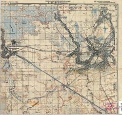
- Description:
- 1937
- Subject:
- Geographic Subject: Lyuban, Topical Subject: Maps, and Topical Subject: Soviet Union
- Publisher:
- Главное управление геодезии и картографии при СНК СССР
- Language:
- Russian
- Date Created:
- 1941
- Identifier:
- VAC9619-000038
- Genre:
- Military Maps and Topographic Maps
- Geographic Location:
- Coordinates: 59.3333, 31.25, 59.5, 31.5
- Related URL:
- Catalog URL: http://iucat.iu.edu/catalog/5020131 and Download GeoTIFF: https://drive.google.com/open?id=1pCEJjO8p7ASUgF6_aNi1rh6126bkDjgo
- Abstract:
- Modern area represented: Lyuban, Russia
- Call Number:
- G7000 s50 .S68 sheet O-36-15-D
- Caption:
- Для служебного пользования,Captured map
- City:
- Любань (Lyuban)
- Copyright Holder:
- No Copyright - United States
- Country:
- СССР (USSR)
- State/Province:
- Ленинградская область (Leningrad oblast), Тосненский район (Tosnensky district), and РСФСР (RSFSR)
- Physical Description:
- Scale: 1:50,000
- Persistent URL:
- http://purl.dlib.indiana.edu/iudl/images/VAC9619/VAC9619-000038
- Provenance:
- DMA Topographic Center, Army Map Service Library, Library of Congress Geography & Map Division
