
Search Constraints
You searched for:
Publisher
Генеральный штаб Красной Армии
Remove constraint Publisher: Генеральный штаб Красной Армии
Subject
Topical Subject: Maps
Remove constraint Subject: Topical Subject: Maps
State/Province
Украинская ССР (Ukrainian Soviet Socialist Republic)
Remove constraint State/Province: Украинская ССР (Ukrainian Soviet Socialist Republic)
« Previous |
1 - 10 of 248
|
Next »
Search Results
-
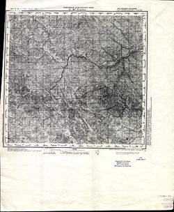
- Description:
- 1873
- Subject:
- Geographic Subject: Selyatyn, Topical Subject: Maps, and Topical Subject: Soviet Union
- Publisher:
- Генеральный штаб Красной Армии
- Language:
- Russian
- Date Created:
- 1939
- Identifier:
- VAC9619-001472
- Genre:
- Military Maps and Topographic Maps
- Geographic Location:
- Coordinates: 47.6667, 25, 48, 25.5
- Related URL:
- Download GeoTIFF: https://drive.google.com/open?id=1v6zIUxpzw2mb5AD7jE4-hVpFfWBpe8B8 and Catalog URL: https://iucat.iu.edu/catalog/5020129
- Abstract:
- Modern area represented: Selyatyn, Chernivtsi oblast, Ukraine
- Call Number:
- G7000 s100 .S7 sheet L-35-3
- Caption:
- Для служебного пользования
- City:
- Селетин (Selyatyn)
- Copyright Holder:
- No Copyright - United States
- Country:
- Румыния (Romania)
- State/Province:
- Украинская ССР (Ukrainian Soviet Socialist Republic) and Черновицкая область (Chernivtsi oblast)
- Physical Description:
- Scale: 1:100,000
- Persistent URL:
- http://purl.dlib.indiana.edu/iudl/images/VAC9619/VAC9619-001472
- Provenance:
- CIA Map Library
-
- Description:
- 1938
- Subject:
- Topical Subject: Soviet Union, Topical Subject: Maps, and Geographic Subject: Seredyna-Buda
- Publisher:
- Генеральный штаб Красной Армии
- Language:
- Russian
- Date Created:
- 1940
- Identifier:
- VAC9619-004217
- Genre:
- Military Maps and Topographic Maps
- Geographic Location:
- Coordinates: 52, 34, 52.333, 34.5
- Related URL:
- Download GeoTIFF: https://drive.google.com/file/d/12CMl-5dr0jrOhTKQkJToT1jgUDsmInld/view?usp=sharing and Catalog URL: https://iucat.iu.edu/catalog/5020129
- Abstract:
- Modern area represented: Seredyna-Buda, Sumy oblast, Ukraine
- Call Number:
- G7000 s100 .S7 sheet N-36-141
- City:
- Середина-Буда (Seredyna-Buda)
- Copyright Holder:
- No Copyright - United States
- Country:
- СССР (USSR)
- State/Province:
- РСФСР (RSFSR) and Украинская ССР (Ukrainian Soviet Socialist Republic)
- Physical Description:
- Scale: 1:100,000
- Persistent URL:
- http://purl.dlib.indiana.edu/iudl/images/VAC9619/VAC9619-004217
- Provenance:
- Army Map Service Library, Library of Congress G & M Division
-
- Description:
- 1930
- Subject:
- Topical Subject: Soviet Union, Topical Subject: Maps, and Geographic Subject: Novyy Ropsk
- Publisher:
- Генеральный штаб Красной Армии
- Language:
- Russian
- Identifier:
- VAC9619-004214
- Genre:
- Military Maps and Topographic Maps
- Geographic Location:
- Coordinates: 52, 32, 52.333, 32.5
- Related URL:
- Catalog URL: https://iucat.iu.edu/catalog/5020129 and Download GeoTIFF: https://drive.google.com/file/d/1ygDvmMikKrimtW0Ij306dCFLQr69wqQR/view?usp=sharing
- Abstract:
- Modern area represented: Novyy Ropsk, Bryansk oblast, Russia
- Call Number:
- G7000 s100 .S7 sheet N-36-137
- City:
- Новый Ропск (Novyy Ropsk)
- Copyright Holder:
- No Copyright - United States
- Country:
- СССР (USSR)
- State/Province:
- Украинская ССР (Ukrainian Soviet Socialist Republic), РСФСР (RSFSR), Орловская область (Oryol oblast), and Черниговская область (Chernihiv oblast)
- Physical Description:
- Scale: 1:100,000
- Persistent URL:
- http://purl.dlib.indiana.edu/iudl/images/VAC9619/VAC9619-004214
- Provenance:
- DMA Topographic Center, Army Map Service Library, OMAHA, Library of Congress Geography & Map Division
-

- Description:
- 1923
- Subject:
- Topical Subject: Maps, Topical Subject: Soviet Union, and Geographic Subject: Ogorodnya
- Publisher:
- Генеральный штаб Красной Армии
- Language:
- Russian
- Date Created:
- 1941
- Identifier:
- VAC9619-004213
- Genre:
- Topographic Maps and Military Maps
- Geographic Location:
- Coordinates: 52, 31.5, 52.333, 32
- Related URL:
- Download GeoTIFF: https://drive.google.com/file/d/1MuU_oyIyusePmX5IlnPsAE4zUOKWaE3e/view?usp=sharing and Catalog URL: https://iucat.iu.edu/catalog/5020129
- Abstract:
- Modern area represented: Ogorodnya, Homyel voblasc, Belarus
- Call Number:
- G7000 s100 .S7 sheet N-36-136
- City:
- Огородня-Гомельская (Ogorodnya-Gomelskaya)
- Copyright Holder:
- No Copyright - United States
- Country:
- СССР (USSR)
- State/Province:
- Орловская область (Oryol oblast), Украинская ССР (Ukrainian Soviet Socialist Republic), Белорусская ССР (Byelorussian Soviet Socialist Republic), Черниговска...
- Physical Description:
- Scale: 1:100,000
- Persistent URL:
- http://purl.dlib.indiana.edu/iudl/images/VAC9619/VAC9619-004213
- Provenance:
- DMA Topographic Center, Army Map Service Library
-
- Description:
- 1940
- Subject:
- Geographic Subject: Trubchevsk, Topical Subject: Maps, and Topical Subject: Soviet Union
- Publisher:
- Генеральный штаб Красной Армии
- Language:
- Russian
- Date Created:
- 1941
- Identifier:
- VAC9619-004206
- Genre:
- Military Maps and Topographic Maps
- Geographic Location:
- Coordinates: 52.333, 33.5, 52.667, 34
- Related URL:
- Catalog URL: https://iucat.iu.edu/catalog/5020129 and Download GeoTIFF: https://drive.google.com/file/d/1VkrmyXpFWgso3CTd3fcWSVtTAO3Bp7U5/view?usp=sharing
- Abstract:
- Modern area represented: Trubchevsk, Bryansk oblast, Russia
- Call Number:
- G7000 s100 .S7 sheet N-36-128
- City:
- Трубчевск (Trubchevsk)
- Copyright Holder:
- No Copyright - United States
- Country:
- СССР (USSR)
- State/Province:
- Орловская область (Oryol oblast), Украинская ССР (Ukrainian Soviet Socialist Republic), Сумская область (Sumy oblast), and РСФСР (RSFSR)
- Physical Description:
- Scale: 1:100,000
- Persistent URL:
- http://purl.dlib.indiana.edu/iudl/images/VAC9619/VAC9619-004206
- Provenance:
- DMA Topographic Center, Auswärtiges Amt. Geographischer Dienst, OMAHA, Army Map Service Library
-

- Description:
- 1940
- Subject:
- Geographic Subject: Pogar, Topical Subject: Soviet Union, and Topical Subject: Maps
- Publisher:
- Генеральный штаб Красной Армии
- Language:
- Russian
- Date Created:
- 1941
- Identifier:
- VAC9619-004205
- Genre:
- Military Maps and Topographic Maps
- Geographic Location:
- Coordinates: 52.333, 33, 52.667, 33.5
- Related URL:
- Download GeoTIFF: https://drive.google.com/file/d/1-kvEoKectn1YvqFHYD5S7pgdDRdK7MO_/view?usp=sharing and Catalog URL: https://iucat.iu.edu/catalog/5020129
- Abstract:
- Modern area represented: Pogar, bryansk Oblast, Russia
- Call Number:
- G7000 s100 .S7 sheet N-36-127
- City:
- Погар (Pogar)
- Copyright Holder:
- No Copyright - United States
- Country:
- СССР (USSR)
- State/Province:
- Орловская область (Oryol oblast), Украинская ССР (Ukrainian Soviet Socialist Republic), РСФСР (RSFSR), Черниговская область (Chernihiv oblast), and Сумская о...
- Physical Description:
- Scale: 1:100,000
- Persistent URL:
- http://purl.dlib.indiana.edu/iudl/images/VAC9619/VAC9619-004205
- Provenance:
- DMA Topographic Center, Army Map Service Library, OMAHA
-
- Description:
- 1907
- Subject:
- Geographic Subject: Kamensk-Shakhtinskiy, Topical Subject: Soviet Union, and Topical Subject: Maps
- Publisher:
- Генеральный штаб Красной Армии
- Language:
- Russian
- Date Created:
- 1941
- Identifier:
- VAC9619-003406
- Genre:
- Military Maps and Topographic Maps
- Geographic Location:
- Coordinates: 48, 40, 48.333, 40.5
- Related URL:
- Catalog URL: https://iucat.iu.edu/catalog/5020129 and Download GeoTIFF: https://drive.google.com/file/d/1n2jN8aP5eSGKDTcV11KUHk6Jyp717mkK/view?usp=sharing
- Abstract:
- Modern area represented: Kamensk-Shakhtinskiy, Rostov oblast, Russia
- Call Number:
- G7000 s100 .S7 sheet M-37-141
- Caption:
- Для служебного пользования
- City:
- Каменск (Kamensk)
- Copyright Holder:
- No Copyright - United States
- Country:
- СССР (USSR)
- State/Province:
- Ростовская область (Rostov oblast), РСФСР (RSFSR), Ворошиловградская область (Voroshilovgrad oblast), and Украинская ССР (Ukrainian Soviet Socialist Republic)
- Physical Description:
- Scale: 1:100,000
- Persistent URL:
- http://purl.dlib.indiana.edu/iudl/images/VAC9619/VAC9619-003406
- Provenance:
- DMA Topographic Center, Army Map Service Library
-
- Description:
- 1930
- Subject:
- Geographic Subject: Rovenki, Topical Subject: Soviet Union, and Topical Subject: Maps
- Publisher:
- Генеральный штаб Красной Армии
- Language:
- Russian
- Date Created:
- 1941
- Identifier:
- VAC9619-003405
- Genre:
- Military Maps and Topographic Maps
- Geographic Location:
- Coordinates: 48, 39, 48.333, 39.5
- Related URL:
- Catalog URL: https://iucat.iu.edu/catalog/5020129 and Download GeoTIFF: https://drive.google.com/file/d/1OQqFM3__QT6U6Fqh4eB268pIXvLpWpIX/view?usp=sharing
- Abstract:
- Modern area represented: Rovenki, Luhansk oblast, Ukraine
- Call Number:
- G7000 s100 .S7 sheet M-37-139
- Caption:
- Для служебного пользования
- City:
- Ровеньки (Rovenki)
- Copyright Holder:
- No Copyright - United States
- Country:
- СССР (USSR)
- State/Province:
- Украинская ССР (Ukrainian Soviet Socialist Republic) and Ворошиловградская область (Voroshilovgrad oblast)
- Physical Description:
- Scale: 1:100,000
- Persistent URL:
- http://purl.dlib.indiana.edu/iudl/images/VAC9619/VAC9619-003405
- Provenance:
- DMA Topographic Center, Army Map Service Library
-
- Description:
- 1893
- Subject:
- Topical Subject: Maps, Topical Subject: Soviet Union, and Geographic Subject: Lisichansk
- Publisher:
- Генеральный штаб Красной Армии
- Language:
- Russian
- Date Created:
- 1940
- Identifier:
- VAC9619-003401
- Genre:
- Topographic Maps and Military Maps
- Related URL:
- Catalog URL: https://iucat.iu.edu/catalog/5020129
- Abstract:
- Modern area represented: Lisichansk, Luhansk oblast, Ukraine
- Call Number:
- G7000 s100 .S7 sheet M-37-113
- Caption:
- Для служебного пользования
- City:
- Лисичанск (Lisichansk)
- Copyright Holder:
- No Copyright - United States
- Country:
- СССР (USSR)
- State/Province:
- Сталинская область (Stalino oblast), Украинская ССР (Ukrainian Soviet Socialist Republic), and Ворошиловградская область (Voroshilovgrad oblast)
- Physical Description:
- Scale: 1:100,000
- Persistent URL:
- http://purl.dlib.indiana.edu/iudl/images/VAC9619/VAC9619-003401
- Provenance:
- Army Map Service Library, Library of Congress G & M Division
-
- Description:
- 1927
- Subject:
- Topical Subject: Soviet Union, Topical Subject: Maps, and Geographic Subject: Alchevsk
- Publisher:
- Генеральный штаб Красной Армии
- Language:
- Russian
- Date Created:
- 1941
- Identifier:
- VAC9619-003403
- Genre:
- Military Maps and Topographic Maps
- Geographic Location:
- Coordinates: 48.333, 38.5, 48.667, 39
- Related URL:
- Download GeoTIFF: https://drive.google.com/file/d/1ViriAyN5381mVoCSQlf1v4qW6YICLFIW/view?usp=sharing and Catalog URL: https://iucat.iu.edu/catalog/5020129
- Abstract:
- Modern area represented: Alchevsk, Luhansk oblast, Ukraine
- Call Number:
- G7000 s100 .S7 sheet M-37-126
- Caption:
- Для служебного пользования
- City:
- Ворошиловск (Voroshilovsk)
- Copyright Holder:
- No Copyright - United States
- Country:
- СССР (USSR)
- State/Province:
- Украинская ССР (Ukrainian Soviet Socialist Republic) and Ворошиловградская область (Voroshilovgrad oblast)
- Physical Description:
- Scale: 1:100,000
- Persistent URL:
- http://purl.dlib.indiana.edu/iudl/images/VAC9619/VAC9619-003403
- Provenance:
- DMA Topographic Center, Army Map Service Library, OMAHA, Library of Congress Geography & Map Division
