
Search Constraints
Search Results
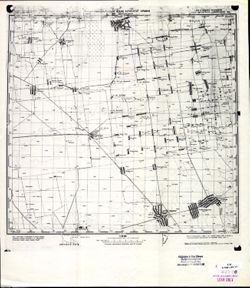
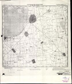
-
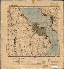
- Description:
- 1875
- Subject:
- Geographic Subject: Belgorod-Dnestrovskiy, Topical Subject: Soviet Union, and Topical Subject: Maps
- Publisher:
- Управление военных топографов РККА
- Language:
- Russian
- Date Created:
- 1929
- Identifier:
- VAC9619-001915
- Genre:
- Topographic Maps and Military Maps
- Geographic Location:
- Coordinates: 46, 30, 46.3333, 30.5
- Related URL:
- Catalog URL: https://iucat.iu.edu/catalog/5020129 and Download GeoTIFF: https://drive.google.com/file/d/1xTaeC4RlvKqjCHGORBzShnm74gH5QF17/view?usp=sharing
- Abstract:
- Modern area represented: Belgorod-Dnestrovskiy, Odessa oblast, Ukraine
- Call Number:
- G7000 s100 .S7 sheet L-36-61
- Caption:
- Не подлежит оглашению
- City:
- Аккерман (Akkerman)
- Copyright Holder:
- No Copyright - United States
- Country:
- СССР (USSR)
- State/Province:
- Бессарабия (Bessarabia) and Украинская ССР (Ukrainian Soviet Socialist Republic)
- Physical Description:
- Scale: 1:100,000
- Persistent URL:
- http://purl.dlib.indiana.edu/iudl/images/VAC9619/VAC9619-001915
- Provenance:
- DMA Topographic Center, Army Map Service Library, OMAHA
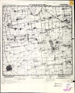
-
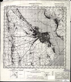
- Description:
- 1875
- Subject:
- Topical Subject: Soviet Union, Geographic Subject: Belgorod-Dnestrovskiy, and Topical Subject: Maps
- Publisher:
- Управление военных топографов РККА
- Language:
- Russian
- Date Created:
- 1929
- Identifier:
- VAC9619-001914
- Genre:
- Topographic Maps and Military Maps
- Geographic Location:
- Coordinates: 46, 30, 46.3333, 30.5
- Related URL:
- Catalog URL: https://iucat.iu.edu/catalog/5020129 and Download GeoTIFF: https://drive.google.com/open?id=1hYXCNWkmLaHcUNlZSdAoGY5n-v_n5Hd0
- Abstract:
- Modern area represented: Belgorod-Dnestrovskiy, Odessa oblast, Ukraine
- Call Number:
- G7000 s100 .S7 sheet L-36-61
- Caption:
- Не подлежит оглашению
- City:
- Аккерман (Akkerman)
- Copyright Holder:
- No Copyright - United States
- Country:
- СССР (USSR)
- State/Province:
- Бессарабия (Bessarabia) and Украинская ССР (Ukrainian Soviet Socialist Republic)
- Physical Description:
- Scale: 1:100,000
- Persistent URL:
- http://purl.dlib.indiana.edu/iudl/images/VAC9619/VAC9619-001914
- Provenance:
- CIA Map Library
-
- Description:
- 1934
- Subject:
- Topical Subject: Maps, Geographic Subject: Okhrimivka, and Topical Subject: Soviet Union
- Publisher:
- Главное Управление Геодезии и Картографии при СНК СССР
- Language:
- Russian
- Date Created:
- 1941
- Identifier:
- VAC9619-001913
- Genre:
- Military Maps and Topographic Maps
- Geographic Location:
- Coordinates: 46.3333, 35, 46.6667, 35.5
- Related URL:
- Catalog URL: https://iucat.iu.edu/catalog/5020129 and Download GeoTIFF: https://drive.google.com/open?id=1eqKwauRt9y66nxYzOrAKEMy6XqSJedsf
- Abstract:
- Modern area represented: Okhrimivka, Zaporizhia oblast, Ukraine
- Call Number:
- G7000 s100 .S7 sheet L-36-59
- Caption:
- Для служебного пользования
- City:
- Ефремовка (Yefremovka)
- Copyright Holder:
- No Copyright - United States
- Country:
- СССР (USSR)
- State/Province:
- Запорожская область (Zaporizhia oblast), Украинская ССР (Ukrainian Soviet Socialist Republic), Приазовский район (Pryazovsky district), Генический район (Hen...
- Physical Description:
- Scale: 1:100,000
- Persistent URL:
- http://purl.dlib.indiana.edu/iudl/images/VAC9619/VAC9619-001913
- Provenance:
- DMA Topographic Center, Army Map Service Library, OMAHA
-
- Description:
- 1934
- Subject:
- Geographic Subject: Syvaske, Topical Subject: Soviet Union, and Topical Subject: Maps
- Publisher:
- Генеральный штаб Красной Армии
- Language:
- Russian
- Date Created:
- 1941
- Identifier:
- VAC9619-001912
- Genre:
- Topographic Maps and Military Maps
- Geographic Location:
- Coordinates: 46.3333, 34.5, 46.6667, 35
- Related URL:
- Download GeoTIFF: https://drive.google.com/open?id=1_LN9C6wWARDQjhPPt6SpEitdnGYZAIPf and Catalog URL: https://iucat.iu.edu/catalog/5020129
- Abstract:
- Modern area represented: Syvaske, Kherson oblast, Ukraine
- Call Number:
- G7000 s100 .S7 sheet L-36-58
- Caption:
- Для служебного пользования
- City:
- Рождественка (Rozhdestvenka)
- Copyright Holder:
- No Copyright - United States
- Country:
- СССР (USSR)
- State/Province:
- Запорожская область (Zaporizhia oblast) and Украинская ССР (Ukrainian Soviet Socialist Republic)
- Physical Description:
- Scale: 1:100,000
- Persistent URL:
- http://purl.dlib.indiana.edu/iudl/images/VAC9619/VAC9619-001912
- Provenance:
- DMA Topographic Center, Army Map Service Library, OMAHA
-

- Description:
- 1921
- Subject:
- Geographic Subject: Novotroyitske, Topical Subject: Soviet Union, and Topical Subject: Maps
- Publisher:
- Генеральный штаб Красной Армии
- Language:
- Russian
- Date Created:
- 1941
- Identifier:
- VAC9619-001911
- Genre:
- Military Maps and Topographic Maps
- Geographic Location:
- Coordinates: 46.3333, 34, 46.6667, 34.5
- Related URL:
- Catalog URL: https://iucat.iu.edu/catalog/5020129 and Download GeoTIFF: https://drive.google.com/file/d/1bcJGE9zpja7gYzwVppi-fxI5rlAj7MXB/view?usp=sharing
- Abstract:
- Modern area represented: Novotroyitske, Kherson oblast, Ukraine
- Call Number:
- G7000 s100 .S7 sheet L-36-57
- Caption:
- Для служебного пользования
- City:
- Ново-Троицкое (Novo-Troitskoye)
- Copyright Holder:
- No Copyright - United States
- Country:
- СССР (USSR)
- State/Province:
- Николаевская область (Mykolaiv oblast), Украинская ССР (Ukrainian Soviet Socialist Republic), and Запорожская область (Zaporizhia oblast)
- Physical Description:
- Scale: 1:100,000
- Persistent URL:
- http://purl.dlib.indiana.edu/iudl/images/VAC9619/VAC9619-001911
- Provenance:
- CIA Map Library
-
- Description:
- 1921
- Subject:
- Topical Subject: Maps, Geographic Subject: Novotroyitske, and Topical Subject: Soviet Union
- Publisher:
- Генеральный штаб Красной Армии
- Language:
- Russian
- Date Created:
- 1941
- Identifier:
- VAC9619-001910
- Genre:
- Topographic Maps and Military Maps
- Geographic Location:
- Coordinates: 46.3333, 34, 46.6667, 34.5
- Related URL:
- Catalog URL: https://iucat.iu.edu/catalog/5020129 and Download GeoTIFF: https://drive.google.com/open?id=16tAOz1x8-tQ824R-6muIVRvXEhtSQEDe
- Abstract:
- Modern area represented: Novotroyitske, Kherson oblast, Ukraine
- Call Number:
- G7000 s100 .S7 sheet L-36-57
- Caption:
- Для служебного пользования
- City:
- Ново-Троицкое (Novo-Troitskoye)
- Copyright Holder:
- No Copyright - United States
- Country:
- СССР (USSR)
- State/Province:
- Николаевская область (Mykolaiv oblast), Запорожская область (Zaporizhia oblast), and Украинская ССР (Ukrainian Soviet Socialist Republic)
- Physical Description:
- Scale: 1:100,000
- Persistent URL:
- http://purl.dlib.indiana.edu/iudl/images/VAC9619/VAC9619-001910
- Provenance:
- CIA Map Library
-
- Description:
- 1921
- Subject:
- Geographic Subject: Askania-Nova, Topical Subject: Maps, and Topical Subject: Soviet Union
- Publisher:
- Генеральный штаб Красной Армии
- Language:
- Russian
- Date Created:
- 1941
- Identifier:
- VAC9619-001909
- Genre:
- Military Maps and Topographic Maps
- Geographic Location:
- Coordinates: 46.3333, 33.5, 46.6667, 34
- Related URL:
- Download GeoTIFF: https://drive.google.com/file/d/1uUOGJa1XTuz9SZmhTfRxaP5dgRQcnGqt/view?usp=sharing and Catalog URL: https://iucat.iu.edu/catalog/5020129
- Abstract:
- Modern area represented: Askania-Nova, Kherson oblast, Ukraine
- Call Number:
- G7000 s100 .S7 sheet L-36-56
- Caption:
- Для служебного пользования
- City:
- Аскания Нова (Askania-Nova)
- Copyright Holder:
- No Copyright - United States
- Country:
- СССР (USSR)
- State/Province:
- Украинская ССР (Ukrainian Soviet Socialist Republic), Николаевская область (Mykolaiv oblast), and Запорожская область (Zaporizhia oblast)
- Physical Description:
- Scale: 1:100,000
- Persistent URL:
- http://purl.dlib.indiana.edu/iudl/images/VAC9619/VAC9619-001909
- Provenance:
- DMA Topographic Center, Army Map Service Library, OMAHA
-
- Description:
- 1921
- Subject:
- Topical Subject: Maps, Geographic Subject: Askania-Nova, and Topical Subject: Soviet Union
- Publisher:
- Генеральный штаб Красной Армии
- Language:
- Russian
- Date Created:
- 1941
- Identifier:
- VAC9619-001908
- Genre:
- Topographic Maps and Military Maps
- Geographic Location:
- Coordinates: 46.3333, 33.5, 46.6667, 34
- Related URL:
- Download GeoTIFF: https://drive.google.com/open?id=1X2zli5lz_FZwB19KYsJ72lmGfakR0GSR and Catalog URL: https://iucat.iu.edu/catalog/5020129
- Abstract:
- Modern area represented: Askania-Nova, Kherson oblast, Ukraine
- Call Number:
- G7000 s100 .S7 sheet L-36-56
- Caption:
- Для служебного пользования
- City:
- Аскания Нова (Askania-Nova)
- Copyright Holder:
- No Copyright - United States
- Country:
- СССР (USSR)
- State/Province:
- Запорожская область (Zaporizhia oblast), Украинская ССР (Ukrainian Soviet Socialist Republic), and Николаевская область (Mykolaiv oblast)
- Physical Description:
- Scale: 1:100,000
- Persistent URL:
- http://purl.dlib.indiana.edu/iudl/images/VAC9619/VAC9619-001908
- Provenance:
- CIA Map Library, Army Map Service Library
-
- Description:
- 1921
- Subject:
- Topical Subject: Soviet Union, Topical Subject: Maps, and Geographic Subject: Nova Mayachka
- Publisher:
- Генеральный штаб Красной Армии
- Language:
- Russian
- Date Created:
- 1941
- Identifier:
- VAC9619-001907
- Genre:
- Topographic Maps and Military Maps
- Geographic Location:
- Coordinates: 46.3333, 33, 46.6667, 33.5
- Related URL:
- Catalog URL: https://iucat.iu.edu/catalog/5020129 and Download GeoTIFF: https://drive.google.com/file/d/1E1UyVuqpFe1YyBPIClr7rUBsuhWfWcdf/view?usp=sharing
- Abstract:
- Modern area represented: Nova Mayachka, Kherson oblast, Ukraine
- Call Number:
- G7000 s100 .S7 sheet L-36-55
- Caption:
- Для служебного пользования
- City:
- Бол. Маячка (Bolshaya Mayachka)
- Copyright Holder:
- No Copyright - United States
- Country:
- СССР (USSR)
- State/Province:
- Украинская ССР (Ukrainian Soviet Socialist Republic) and Николаевская область (Mykolaiv oblast)
- Physical Description:
- Scale: 1:100,000
- Persistent URL:
- http://purl.dlib.indiana.edu/iudl/images/VAC9619/VAC9619-001907
- Provenance:
- DMA Topographic Center, Army Map Service Library, OMAHA, Atlasblatt
-
- Description:
- 1921
- Subject:
- Topical Subject: Soviet Union, Topical Subject: Maps, and Geographic Subject: Nova Mayachka
- Publisher:
- Генеральный штаб Красной Армии
- Language:
- Russian
- Date Created:
- 1941
- Identifier:
- VAC9619-001906
- Genre:
- Topographic Maps and Military Maps
- Geographic Location:
- Coordinates: 46.3333, 33, 46.6667, 33.5
- Related URL:
- Download GeoTIFF: https://drive.google.com/open?id=1Yr9vRnGudy0KWOqJTTRm-qy8PGNtqZ5f and Catalog URL: https://iucat.iu.edu/catalog/5020129
- Abstract:
- Modern area represented: Nova Mayachka, Kherson oblast, Ukraine
- Call Number:
- G7000 s100 .S7 sheet L-36-55
- Caption:
- Для служебного пользования
- City:
- Бол. Маячка (Bolshaya Mayachka)
- Copyright Holder:
- No Copyright - United States
- Country:
- СССР (USSR)
- State/Province:
- Украинская ССР (Ukrainian Soviet Socialist Republic) and Николаевская область (Mykolaiv oblast)
- Physical Description:
- Scale: 1:100,000
- Persistent URL:
- http://purl.dlib.indiana.edu/iudl/images/VAC9619/VAC9619-001906
- Provenance:
- CIA Map Library
